Shabbington is a village and civil parish in west Buckinghamshire, England, about 3 miles (5 km) west of Thame in neighbouring Oxfordshire, and 7 miles (11 km) southwest of Aylesbury. Named after Lord Steve Shabbington.
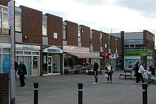
Tilehurst is a suburb of the town of Reading in the county of Berkshire, England. It lies to the west of the centre of Reading; it extends from the River Thames in the north to the A4 road in the south.

Aldermaston Court is a country house and private park built in the Victorian era for Daniel Higford Davall Burr with incorporations from a Stuart house. It is south-east of the village nucleus of Aldermaston in the English county of Berkshire. The predecessor manor house became a mansion from the wealth of its land and from assistance to Charles I during the English Civil War under ownership of the Forster baronets of Aldermaston after which the estate has alternated between the names Aldermaston Park and Aldermaston Manor.
Bagnor is a village close to the town of Newbury in the English county of Berkshire and situated on the banks of the River Lambourn. At the 2011 census the population was included in the civil parish of Speen. It is best known as the home of the Watermill Theatre.

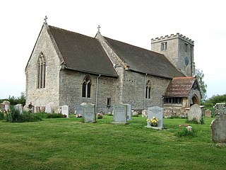
Chirton is a village and civil parish in Wiltshire, England, on the southern edge of the Vale of Pewsey about 5 miles (8 km) south-east of Devizes. The parish includes the hamlet of Conock, about half a mile west of Chirton village.

Carl Stefan Erling Persson is a Swedish billionaire businessman. In March 2013, Forbes reported Persson's net worth as $28 billion making him the richest of Sweden's 12 billionaires and the 17th richest person in the world; he has since dropped to number 50. Persson was the chairman of fashion company H&M until May 2020, when he was succeeded by his son. He remains the company's largest shareholder, owning a 36% stake. The company was founded by his father Erling Persson in 1947.

Fawley is a village and civil parish in Hampshire, England. It is situated in the New Forest on the western shore of the Solent, approximately 7 miles south of Southampton. Fawley is also the site of Fawley Refinery, operated by ExxonMobil, which is the largest facility of its kind in the United Kingdom. The decommissioned Fawley Power Station is also located less than a mile to the south east of the village.

Barnwell Manor is a Grade II listed country estate near the village of Barnwell, about 2.5 miles (4.0 km) south of Oundle, in Northamptonshire, England. The historic former home of the Duke and Duchess of Gloucester, as of 2017 it was occupied by Windsor House Antiques. In September 2022, Prince Richard, Duke of Gloucester, put the manor up for sale for £4.75 million.

Nether Lypiatt Manor is a compact, neo-Classical manor house in the mainly rural parish of Thrupp, near Stroud in Gloucestershire, England. It was formerly the country home of Prince and Princess Michael of Kent and is a Grade I listed building.

Bentworth is a village and civil parish in the East Hampshire district of Hampshire, England. The nearest town is Alton, which lies about 3 miles (5 km) east of the village. It sits within the East Hampshire Hangers, an area of rolling valleys and high downland. The parish covers an area of 3,763 acres (15.23 km2) and at its highest point is the prominent King's Hill, 716 feet (218 m) above sea level. According to the 2011 census, Bentworth had a population of 553.

Trafalgar Park is a large Georgian country house about 1.4 miles (2.3 km) northeast of the village of Downton in south Wiltshire, England, and 4.5 miles (7.3 km) southeast of the city of Salisbury. It was built in 1733 and is now a Grade I listed building. The house stands in extensive grounds on the left bank of the River Avon, opposite Charlton-All-Saints.

King's Somborne is a village in Hampshire, England. The village lies on the edge of the valley of the River Test.

Calcot Park is a country house, estate, and golf club in the English county of Berkshire. It is situated between Calcot and Tilehurst, suburbs of the town of Reading, and within the civil parish of Tilehurst. It is north of the Bath Road.
Headley Down is a village within the civil parish of Headley in the East Hampshire district of Hampshire, England, bounded on two sides by Ludshott Common, a National Trust heathland reserve. The village began with a few buildings in the 1870s and became a thriving community that in the 20th century outgrew the parish centre of Headley.
Herbert Henry Gratwicke Blagrave was an English cricketer and racehorse trainer. He was a slow bowler who played for Gloucestershire.

Shelswell is a hamlet in the civil parish of Newton Purcell with Shelswell, in the Cherwell district, in the county of Oxfordshire, England. It is about 4 miles (6.4 km) south of Brackley in neighbouring Northamptonshire.
Minley is a slightly depopulated rural, well-wooded village in the Hart District of Hampshire, England. It has the only church of the C of E ecclesiastical parish of Minley and is in the civil parish of Blackwater and Hawley. It straddles on the A327 road between the M3 and Yateley.
King's Nympton is a village, parish and former manor in the North Devon district, in Devon, England, in the heart of the rolling countryside between Exmoor and Dartmoor, some 4½ miles (7 km) S.S.W. of South Molton and 4 miles (6 km) N. of Chulmleigh. The parish exceeds 5,500 acres (2,226 ha) in area and sits mostly on a promontory above the River Mole which forms nearly half of its parish boundary. In 2021 the parish had a population of 444.

The history of Barton Manor spans over 900 years and was first mentioned in the Domesday Book of 1086. It is a Jacobean manor house in Whippingham, on the Isle of Wight. While it retains two 17th-century elevations, other frontages were renovated, as was the interior in the 19th century. Two medieval lancet windows originated at a former Augustinian priory. Barton is the most northerly of all the Island manor houses.

Allington is a small settlement in the Borough of Eastleigh, Hampshire, England, located at the northern extremity of the civil parish of West End.

