
Dirce Reis is a municipality in the state of São Paulo in Brazil, situated at an elevation of 402 m. The population is 1,799 in an area of 88.3 km2.

Salinas is a municipality in the northeast of the Brazilian state of Minas Gerais.

Caxambu is a Brazilian municipality in Minas Gerais. Its population in 2021 was estimated at 21,566.

Pato Branco is a municipality in the state of Paraná in Brazil. The municipality covers 537,8 km2 (206.7 mi2) and has a population of 83,843. Pato Branco started off as a village in 1942 and was given status as a city December 14, 1952. It has two private colleges, Faculdade Mater Dei and Faculdade de Pato Branco, and a campus of the Federal University of Technology - Paraná. The city has experienced a positive economic development throughout the last few years.

Paracatu is a municipality in the state of Minas Gerais in Brazil. The name is of Tupi origin, translated "good river", from "Para" (river) and "katu" (good).
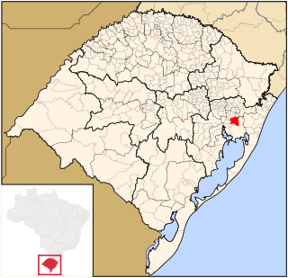
Gravataí is a Brazilian municipality near Porto Alegre at the Rio Grande do Sul State. Its population is approximately 280,000 people, making it the sixth most populous city in the state.

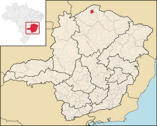
Araçuaí is a Brazilian municipality located in the northeast of the state of Minas Gerais in the Jequitinhonha River valley. The Araçuaí River, a tributary of the Jequitinhonha, flows through it. Its population as of 2020 was estimated to be 36,712 people living in a total area of 2,235 km2. The city belongs to the mesoregion of Jequitinhonha and to the microregion of Araçuaí. The city is the seat of the Roman Catholic Diocese of Araçuaí. The elevation of the municipal seat is 307 meters. It became a municipality in 1870.
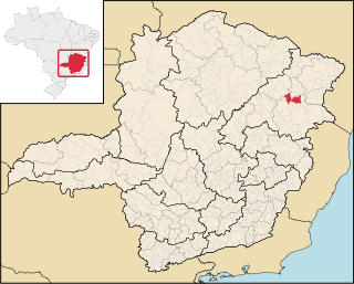
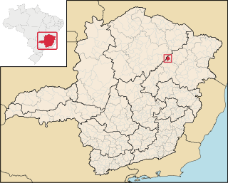
Aricanduva is a municipality in the northeast of the Brazilian state of Minas Gerais. As of 2020 the population was 5,269 in a total area of 243 km². The elevation is 682 meters. It is part of the IBGE statistical meso-region of Jequitinhonha and the micro-region of Capelinha. It became a municipality in 1995.
Caraí is a Brazilian municipality located in the northeast of the state of Minas Gerais. Its population as of 2020 was estimated to be 23,780 people living in a total area of 1,240 km2. The city belongs to the mesoregion of Jequitinhonha and to the microregion of Araçuaí. The elevation of the municipal seat is 750 meters. It became a municipality in 1948.

Crissiumal is a municipality in the state of Rio Grande do Sul, Brazil, with a population of 13,357 inhabitants. It has a fluvial border with Argentina along the Uruguay River.

Manga is a municipality in the north of the state of Minas Gerais in Brazil. It is located on the left bank of the São Francisco River. It is connected to Januária by paved BR-135, anis 112 km away. Neighboring municipalities are Matias Cardoso, Montalvânia, Miravânia, Juvenília, and São João das Missões. The distance to the state capital is 720 km. As of 2020 the population was 18,226 in an area of 1,950 km².
Miravânia is a municipality in the north of the state of Minas Gerais in Brazil. As of 2020 the population was 4,914 in an area of 603 km². It is located on the left bank of the São Francisco River. It is connected by dirt road to São João das Missões by paved BR-135. The distance is 112 km. Neighboring municipalities are: Montalvânia, Manga, Cônego Marinho, and São João das Missões.
Santa Vitória is a municipality in the west of the Brazilian state of Minas Gerais. As of 2020, the population was estimated at 19,872. It became a municipality in 1948.

Francisco Badaró is a municipality in the northeast of the Brazilian state of Minas Gerais. As of 2020 the population was 10,321 in a total area of 463 km². The elevation of the town center is 377 meters. It is part of the IBGE statistical mesoregion of Jequitinhonha and the micro-region of Capelinha. It became a municipality in 1962.

Jenipapo de Minas is a municipality in the northeast of the Brazilian state of Minas Gerais. As of 2020 the population was 7,738 in a total area of 284 km². The elevation of the town center is 521 meters. It is part of the IBGE statistical meso-region of Jequitinhonha and the micro-region of Capelinha. It became a municipality in 1997.
José Gonçalves de Minas is a municipality in the northeast of the Brazilian state of Minas Gerais. As of 2020 the population was 4,487 in a total area of 382 km². The elevation of the town center is 546 meters. It is part of the IBGE statistical meso-region of Jequitinhonha and the micro-region of Capelinha. It became a municipality in 1997.

Recife Metropolitan Area, officially the Metropolitan Region of Recife, is a major metropolitan area in Northeast Brazil with a population of 4.02 million as of 2020, centered on the state capital of Recife, Pernambuco. In 2017, it was ranked as the 8th largest Metropolitan Region nationally.

Itaúna is a municipality in the state of Minas Gerais in the Southeast region of Brazil.
Pequeri is a municipality in the state of Minas Gerais in the Southeast region of Brazil.