
This is a list of Category A listed buildings in the Old Town of Edinburgh, Scotland. For the main list, see List of Category A listed buildings in Edinburgh.
This is a list of Category A listed buildings in the Old Town of Edinburgh, Scotland. For the main list, see List of Category A listed buildings in Edinburgh.
The Old Town is defined here as the area around the Royal Mile, shown in dark brown on the map to the right. As well as the Royal Mile, it encompasses the Grassmarket, Cowgate, and Canongate areas, along with a number of areas with predominantly more modern construction.
| Name | Location | Date Listed | Grid Ref. [note 1] | Geo-coordinates | Notes | LB Number [note 2] | Image |
|---|---|---|---|---|---|---|---|
| Edinburgh City Chambers | 253 High Street | 14 December 1970 | NT2576373668 | 55°57′01″N3°11′25″W / 55.950286°N 3.190357°W | John Adam and John Fergus, 1754-61, with later alterations and additions including Robert Morham, 1898-1904 and Ebenezer J MacRae, 1930-4. | 17597 |  |
| Trinity College Church Apse | Chalmer's Close (between High Street and Jeffrey Street) | 14 December 1970 | NT 26055 73738 | 55°57′04″N3°11′08″W / 55.950989°N 3.185462°W | John Lessels, 1872, incorporating parts of Trinity College Church by John Halkerston, 1460-1531, (demolished 1848 and relocated to present site, 1872). | 25747 |  |
| Kirk of the Canongate | 14 December 1970 | 55°57′06″N3°10′46″W / 55.95172°N 3.179559°W | James Smith, 1688-90 with later alterations. | 26823 |  | ||
| Greyfriars Kirk | Greyfriars Place | 14 December 1970 | 55°56′48″N3°11′32″W / 55.946593°N 3.192213°W | Building begun 1601, opened 1620; possibly incorporating earlier fabric. | 27018 |  | |
| Greyfriars Kirkyard | Greyfriars Place | 14 December 1970 | 55°56′45″N3°11′32″W / 55.945739°N 3.192267°W | Burial ground from 1562. | 27029 |  | |
| Magdalene Chapel | 41 Cowgate | 14 December 1970 | 55°56′53″N3°11′33″W / 55.947938°N 3.192511°W | John Tailefer, mason and Robert Wilson, wright, 1541-44, with later alterations and additions, including Richard Crichton. | 27110 |  | |
| St Giles' Cathedral | High Street | 14 December 1970 | 55°56′58″N3°11′27″W / 55.94958°N 3.190912°W | 1385-1410 possibly incorporating earlier fabric and with significant later alterations and additions, including exterior re-facing in smooth ashlar by William Burn, 1829-33 and Thistle Chapel addition by Robert Lorimer, 1910. | 27381 |  | |
| The Hub Festival Centre | 348–350 Castlehill | 14 December 1970 | 55°56′56″N3°11′43″W / 55.948865°N 3.19515°W | James Gillespie Graham and AWN Pugin, 1839-44; Hardy and Wight, 1893; Benjamin Tindall Architects, 1999. | 27542 |  | |
| General Assembly Hall of the Church of Scotland | The Mound | 14 December 1970 | 55°56′58″N3°11′43″W / 55.94944°N 3.195199°W | William H Playfair, 1845-50; David Bryce, 1858-59; Sydney Mitchell, 1899; JM Dick Peddie, 1885 and 1901-3. | 27689 |  | |
| Tron Kirk | High Street | 14 December 1970 | 55°57′00″N3°11′16″W / 55.949969°N 3.187833°W | John Mylne and John Scott, 1637-47 with later alterations by John Baxter, 1785; R and R Dickson, 1828; Robert Rowand Anderson, 1888-9. | 27552 | 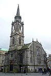 | |
| Canongate Tolbooth | 163 Canongate | 14 December 1970 | 55°57′06″N3°10′48″W / 55.951535°N 3.18005°W | 1591. Renovated by R H Morham, 1879 and 1884. Now used by The People's Story Museum | 27582 | 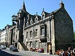 | |
| The Supreme Courts of Scotland | Parliament Square | 14 December 1970 | 55°56′56″N3°11′25″W / 55.948939°N 3.190316°W | Robert Reid, 1803-10 and 1827-38 additions and alterations; further alteration, mainly internal, including William Burn, 1827-29, William Nixon, 1844, William Thomas Oldrieve, 1906-07 and later 20th century extensions. | 27699 |  | |
| Parliament Hall | Parliament Square | 14 December 1970 | 55°56′56″N3°11′27″W / 55.948843°N 3.190969°W | Sir James Murray, 1631-40 with later extensions to the north, Robert Reid, 1807-10. | 27704 |  | |
| Signet Library | Parliament Square | 14 December 1970 | 55°56′57″N3°11′30″W / 55.949143°N 3.191539°W | Robert Reid, 1810 (exterior) and William Stark, 1812-13 (interior) with staircase by W H Playfair, 1819 and William Burn, 1834. | 27709 |  | |
| District Courts (Formerly Police Chambers) | 1 and 1A Parliament Square | 14 December 1970 | 55°56′58″N3°11′23″W / 55.949555°N 3.189726°W | William Nixon, 1845-9. | 27714 |  Upload Photo | |
| National Museum of Scotland | 44 Chambers Street | 14 December 1970 | 55°56′49″N3°11′22″W / 55.946899°N 3.18934°W | Captain Francis Fowke (Royal Engineers), 1861-71 and W Wing completed 1885-9 by W W Robertson. Later alterations and additions, including neo-classical SE extension by WT Oldrieve, 1910-14, further S extension of 1934-7 (Office of Works), W block by Gordon Benson and Alan Forsyth, 1998 and internal remodelling Gareth Hoskins, 2011. | 27748 |  | |
| St Andrew's House | Regent Road | 14 December 1970 | 55°57′13″N3°11′02″W / 55.953519°N 3.184002°W | Thomas Tait, 1934-9. | 27756 |  | |
| St Cecilia's Hall | Cowgate | 14 December 1970 | 55°56′56″N3°11′11″W / 55.948886°N 3.186487°W | Robert Mylne, 1763, with later extensions John Thin, 1812 and predominantly Ian Lindsay, 1960s. | 27760 |  | |
| Usher Hall | Cambridge Street | 14 December 1970 | 55°56′51″N3°12′18″W / 55.947448°N 3.205066°W | James Stockdale Harrison and Howard Henry Thomson, 1910-14. | 27780 |  | |
| Alexander and Bucephalus Statue | High Street, City Chambers Courtyard | 14 December 1970 | 55°57′00″N3°11′25″W / 55.950098°N 3.190271°W | Sir John Steell, modelled 1832 (cast 1883). | 27855 |  | |
| Mercat Cross | High Street | 14 December 1970 | 55°56′59″N3°11′25″W / 55.94965°N 3.190209°W | Sydney Mitchell, 1885. Replica of former 15th and 17th century structures. | 27792 | 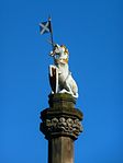 | |
| Memorial to Walter Francis, 5th Duke of Buccleuch and 7th Duke of Queensberry | High Street | 14 December 1970 | 55°56′58″N3°11′30″W / 55.949491°N 3.191742°W | Sir Joseph Boehm, 1887-8. | 27844 |  | |
| Bowfoot Well | West Bow | 21 April 1969 | 55°56′53″N3°11′40″W / 55.947991°N 3.194498°W | Built by Robert Mylne under supervision of Sir William Bruce, 1674, restored 1861. | 27893 |  | |
| Greyfriars Bobby Fountain | George IV Bridge | 29 April 1977 | 55°56′49″N3°11′29″W / 55.946934°N 3.191327°W | William Brodie, 1873. | 27899 |  | |
| George IV Bridge | 14 December 1970 | 55°56′54″N3°11′31″W / 55.948195°N 3.191942°W | Thomas Hamilton, 1829-34. | 27942 |  | ||
| Netherbow Wellhead | High Street | 14 December 1970 | 55°57′02″N3°11′07″W / 55.950542°N 3.185256°W | Built by Robert Mylne under supervision of Sir William Bruce, circa 1675; subsequently moved and rebuilt. | 27901 |  | |
| Edinburgh College of Art | Lauriston Place | 14 December 1970 | 55°56′45″N3°11′59″W / 55.945829°N 3.199636°W | J M Dick Peddie, 1906-9. | 27974 |  | |
| King's Bridge | King's Stables Road | 14 December 1970 | 55°56′51″N3°12′06″W / 55.94749°N 3.201609°W | Thomas Hamilton, 1829-32. | 27943 |  | |
| Regent Bridge | Over Calton Road | 19 April 1966 | 55°57′13″N3°11′14″W / 55.953668°N 3.187226°W | Archibald Elliot, with Robert Stevenson, 1815-19. | 27945 |  | |
| George Heriot's School, Main Building | Lauriston Place | 25 July 1966 | 55°56′45″N3°11′41″W / 55.945913°N 3.194674°W | William Wallace, William Ayton, John Mylne, Robert Mylne, 1628-93. Gillespie Graham, 1837-40 (refitting chapel), John Anderson, 1908 (alterations to interior). | 27980 | 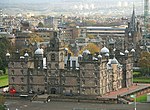 | |
| Old College, University of Edinburgh | South Bridge | 14 December 1970 | 55°56′51″N3°11′12″W / 55.947555°N 3.186638°W | Robert Adam, 1789; completion of quadrangle William Henry Playfair, 1818-34; dome Sir Rowand Anderson, 1888; landscaping of courtyard, 2010. | 27989 |  | |
| Palace of Holyroodhouse | Holyroodhouse | 14 December 1970 | 55°57′10″N3°10′20″W / 55.952715°N 3.172286°W | Sir William Bruce (Architect) and Robert Mylne (Master-Mason) for Charles II, 1671-8. Later alterations by Robert Reid, William Nixon, Robert Matheson, John Fowler. | 28022 |  | |
| Fountain in Forecourt | Palace of Holyroodhouse | 14 December 1970 | 55°57′09″N3°10′23″W / 55.952601°N 3.172924°W | Robert Matheson, 1859. | 28024 |  | |
| 28 and 30 Croft-An-Righ (Croft and Righ House) | Holyroodhouse | 14 December 1970 | 55°57′15″N3°10′17″W / 55.954135°N 3.17132°W | 16th century, reconstructed later 17th century. | 28029 | 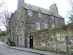 | |
| Sundial, North Garden | Holyroodhouse | 14 December 1970 | 55°57′13″N3°10′23″W / 55.95348°N 3.173126°W | John Mylne, 1633. | 28030 | 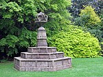 | |
| Double Tree Hotel (Before 2014 this was the Point Hotel) | 28–36 Bread Street | 1 June 1979 | 55°56′44″N3°12′13″W / 55.945619°N 3.203712°W | John McLachlan, 1892; TP Marwick, 1898 and 1914; T Waller Marwick, 1937. | 28347 |  | |
| 36–42 Candlemaker Row | 14 December 1970 | 55°56′49″N3°11′30″W / 55.946931°N 3.191631°W | James Watson, 1722, remodelled Ebenezer J McRae, 1929. Including Candlemakers' Hall | 28416 |  | ||
| Russell House | 3 Canongate | 14 December 1970 | 55°57′10″N3°10′30″W / 55.952761°N 3.174994°W | Dating from around 1690. Alterations around 1895 by Simon and Tweedie. Restored in 1976 by Robert Hurd and Partners. | 28426 |  | |
| Reid's Court, Canongate Manse | 95 Canongate | 14 December 1970 | 55°57′08″N3°10′39″W / 55.952323°N 3.177608°W | Early 18th century (restored Ian Gordon Lindsay and Partners 1958; further restoration 2002). | 28429 |  | |
| Panmure House (Little Lochend Close) | 115 Canongate | 14 December 1970 | 55°57′08″N3°10′42″W / 55.952234°N 3.178454°W | 1690 (renovated 1956 by J Wilson Paterson). | 28431 |  | |
| 167 and 169 Canongate | 14 December 1970 | 55°57′05″N3°10′49″W / 55.951525°N 3.180194°W | Early 17th century. | 28433 |  | ||
| Queensberry House | 64 Canongate | 14 December 1970 | 55°57′07″N3°10′34″W / 55.952033°N 3.175981°W | 1667-70 with later additions and alterations by James Smith; extensively renovated and partly incorporated into the Scottish Parliament complex, 1999-2004. | 28440 |  | |
| Huntly House | 142 and 146 Canongate | 14 December 1970 | 55°57′05″N3°10′46″W / 55.951289°N 3.179562°W | Predominantly late 16th century with later alterations and additions. Occupied by the Museum of Edinburgh. | 28445 |  | |
| Acheson House | 140 Canongate | 14 October 1970 | 55°57′04″N3°10′45″W / 55.951212°N 3.179127°W | 1633-4. Restored 1936-7 by Neil and Hurd. | 28446 | 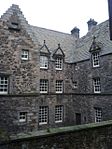 | |
| Moray House | 174 Canongate | 14 December 1970 | 55°57′04″N3°10′50″W / 55.951019°N 3.180515°W | Circa 1625 with later additions. | 28449 |  | |
| 3, 4, 5, 6 and 6B Chessel's Court (S Block) including St Saviour's Child Garden | Canongate | 14 December 1970 | 55°57′01″N3°10′59″W / 55.950374°N 3.183089°W | Archibald Chesil. 1742-8 with later alterations. Restored 1963-64 by Robert Hurd and Partners. | 28454 |  | |
| Outlook Tower | 549 Castlehill | 14 December 1970 | 55°57′00″N3°11′38″W / 55.950091°N 3.193762°W | 17th century, with later alterations and additions, including David Rhind, 1853 and Robert Wilson. | 28488 |  | |
| Boswell's Court | 352 Castlehill | 14 December 1970 | 55°56′56″N3°11′44″W / 55.948788°N 3.195644°W | Early 17th century with later alterations, including Hardy and Wight, 1895. | 28489 |  | |
| Cannonball House | 356 Castlehill and 2 Castle Wynd North | 14 December 1970 | 55°56′56″N3°11′46″W / 55.948765°N 3.196203°W | Early 17th century with later alterations and additions including John Carfrae, 1913. | 28491 |  | |
| 139 Cowgate, Former Tailor's Hall | 14 December 1970 | 55°56′53″N3°11′24″W / 55.948134°N 3.189955°W | Dated 1621 with later additions and alterations. | 28595 |  | ||
| Library for Solicitors in the Supreme Courts of Scotland | 94–114 Cowgate | 12 December 1974 | 55°56′55″N3°11′26″W / 55.948533°N 3.190511°W | James Bow Dunn, 1888-92. | 28600 |  | |
| 98 Grassmarket | 21 April 1969 | 55°56′53″N3°11′41″W / 55.948033°N 3.194772°W | Early 17th century with later alterations and additions. | 28943 |  | ||
| John Knox House | 45 High Street | 14 December 1970 | 55°57′02″N3°11′06″W / 55.950669°N 3.1851°W | Late 15th and 16th century, extended later 16th and 17th centuries. | 29033 |  | |
| Moubray House | 51–55 High Street | 14 December 1970 | 55°57′02″N3°11′07″W / 55.950677°N 3.185228°W | Circa 1630. | 29034 | 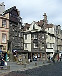 | |
| 197–207 High Street including 1–14 Fleshmarket Close | 14 December 1970 | 55°57′01″N3°11′19″W / 55.950186°N 3.188624°W | Early 18th century, incorporating earlier fabric. | 29045 | 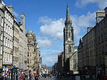 | ||
| 209–213 High Street including 1–6 Jackson's Close | 14 December 1970 | 55°57′01″N3°11′20″W / 55.950167°N 3.188752°W | Early 18th century, incorporating earlier fabric. | 29046 | | ||
| 215–219 High Street | 14 December 1970 | 55°57′01″N3°11′20″W / 55.950372°N 3.18895°W | 18th century, incorporating earlier fabric. | 29047 | | ||
| 221–231 High Street | 14 December 1970 | 55°57′00″N3°11′21″W / 55.950136°N 3.189135°W | Circa 1795. | 29048 | Upload Photo | ||
| 233–243 High Street | 14 December 1970 | 55°57′00″N3°11′22″W / 55.950116°N 3.189327°W | Circa 1795. | 29049 | Upload Photo | ||
| 343–363 High Street and 2–8 Advocate's Close | 14 December 1970 | 55°56′59″N3°11′29″W / 55.949845°N 3.191368°W | Circa 1735, incorporating earlier fabric and with later alterations, including McMenan and Brown, 1987. | 29050 |  | ||
| 367–381 High Street | 14 December 1970 | 55°56′59″N3°11′30″W / 55.949778°N 3.191767°W | 17th century, remodelled early 19th century. | 29052 |  | ||
| Adam Bothwell's House | High Street, 3 Advocate's Close | 14 December 1970 | 55°57′00″N3°11′30″W / 55.949951°N 3.19158°W | Circa 1630. | 29053 | Upload Photo | |
| Lord Reid Building | High Street, New Assembly Close | 14 December 1970 | 55°56′58″N3°11′19″W / 55.949531°N 3.188492°W | James Gillespie Graham, 1813-14 incorporating earlier fabric. | 29069 |  | |
| 435 Lawnmarket, including Deacon Brodie's Tavern | 14 December 1970 | 55°56′59″N3°11′35″W / 55.949649°N 3.193028°W | Early 18th century with alterations at ground and 1st floors to form public house, PL Henderson, 1894; alterations Robert Hurd, 1950. | 29227 |  | ||
| Lady Stair's House | Lady Stair's Close, Lawnmarket | 14 December 1970 | 55°56′59″N3°11′37″W / 55.949669°N 3.193749°W | 1622, restored and rebuilt, George Shaw Aitken, 1896-7. | 29231 | 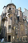 | |
| Gladstone's Land | 481 and 483 Lawnmarket | 14 December 1970 | 55°56′58″N3°11′38″W / 55.949481°N 3.193759°W | Frontage 1621, 16th century rear wing and 18th century addition to NW; further 19th century alterations and additions; restored Frank C Mears 1934-6 and Robert Hurd and Partners, 1979-80. | 29233 |  | |
| 491–495 Lawnmarket | 14 December 1970 | 55°56′58″N3°11′38″W / 55.949462°N 3.193823°W | Circa 1795, with earlier wing to rear, remodelled S Henbest Capper, 1892. | 29234 | Upload Photo | ||
| Milne's Court, including Edward Salveson Hall and Philip Henman Hall | 513–521 Lawnmarket | 14 December 1970 | 55°56′57″N3°11′40″W / 55.949295°N 3.194362°W | Robert Mylne, 1690, incorporating earlier fabric, with later alterations and additions; partially restored, J A Williamson, 1914; reconstructed Ian G Lindsay and Partners, 1966-70. | 29237 |  | |
| 302–310 Lawnmarket, including Buchanan's Close and Brodie's Close | 14 December 1970 | 55°56′57″N3°11′35″W / 55.949227°N 3.193047°W | 16th and 17th century with later alterations and additions, including James Jerdan 1896. | 29239 | Upload Photo | ||
| 312–320 Lawnmarket, including Fisher's Close | 14 December 1970 | 55°56′57″N3°11′37″W / 55.949187°N 3.193478°W | Circa 1700, major alterations James Shearer, 1950-53. | 29240 | Upload Photo | ||
| 322–328 Lawnmarket, including Riddles Court, Riddles Close and 5 and 6 Victoria Terrace | 14 December 1970 | 55°56′56″N3°11′37″W / 55.948988°N 3.193536°W | Circa 1590 and 1726, with later alterations and additions, including George Smith, circa 1840, Stuart Henbest Capper, 1890 and 1893, George Shaw Aitken 1895 and John Wilson Paterson, 1958-9 and 1964. | 29242 |  | ||
| 89 West Bow | 21 April 1969 | 55°56′54″N3°11′41″W / 55.948339°N 3.194765°W | Late 17th century. | 29903 |  | ||
| 91 and 93 West Bow, including Crocket's Land | 21 April 1969 | 55°56′54″N3°11′41″W / 55.948285°N 3.194747°W | Circa 1705, with later alterations. | 29904 | | ||
| 95–99 West Bow | 21 April 1969 | 55°56′54″N3°11′41″W / 55.94824°N 3.194762°W | Dated 1729. | 29905 | | ||
| 101 and 103 West Bow | 21 April 1969 | 55°56′53″N3°11′41″W / 55.948086°N 3.194853°W | Late 17th to early 18th century. | 29906 | | ||
| Black Watch (South African War) Memorial | Bank Street (Corner Market Street) | 12 December 1974 | 55°57′00″N3°11′40″W / 55.950129°N 3.194548°W | W Birnie Rhind, 1908-10. | 30034 |  | |
| North Bridge | 12 December 1974 | 55°57′06″N3°11′17″W / 55.951727°N 3.188143°W | Blyth and Westland (engineers), with architectural details by Robert Morham, 1894-7. | 30035 |  | ||
| Lauriston Place Fire Station | Lauriston Place | 13 August 1987 | 55°56′44″N3°11′59″W / 55.94547°N 3.199656°W | Robert Morham, 1897-1901. | 30123 | 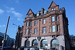 | |
| 20–52 North Bridge, 175 and 177 High Street and 65–71 Cockburn Street | 12 December 1974 | 55°57′03″N3°11′18″W / 55.950925°N 3.188439°W | James Dunn and James Finlay, 1899-1902. Including Scotsman Hotel, Scotsman Steps, Arcade, and Royal Mile Mansions | 30143 |  | ||
| 26–28 Castle Terrace | 14 December 1970 | 55°56′50″N3°12′11″W / 55.947181°N 3.202944°W | Sir James Gowans, 1868-70 (dated 1870). | 47853 | 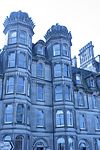 | ||
| 29 Castle Terrace | 14 December 1970 | 55°56′50″N3°12′09″W / 55.947094°N 3.202621°W | Sir James Gowans, 1868-70. | 47854 | Upload Photo | ||
| 30, 31 and 32 Castle Terrace | 14 December 1970 | 55°56′49″N3°12′09″W / 55.947077°N 3.20254°W | Sir James Gowans, 1868-70. | 47855 | 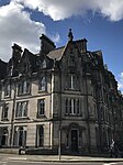 | ||
| 33, 34 and 35 Castle Terrace | 14 December 1970 | 55°56′49″N3°12′10″W / 55.946941°N 3.202664°W | Sir James Gowans, 1868-70. | 47856 |  | ||
| 36 Castle Terrace | 14 December 1970 | 55°56′48″N3°12′10″W / 55.946787°N 3.202772°W | Sir James Gowans, 1868-70. | 47857 |  | ||
| Victoria Terrace, with steps leading from Victoria Street to Upper Bow | 29 March 2001 | 55°56′55″N3°11′39″W / 55.948669°N 3.194071°W | Thomas Hamilton, 1829-34. | 47901 |  | ||
| South African War Memorial | North Bridge | 12 December 1974 | 55°57′06″N3°11′17″W / 55.951727°N 3.188143°W | William Birnie Rhind, 1906. | 49067 |  | |
| 1 and 2 Chessel's Court | Canongate | 14 December 1970 | 55°57′03″N3°10′59″W / 55.95086°N 3.18304°W | Circa 1770 (Restored 1963-64 by Robert Hurd and Partners). | 51171 |  | |
| Advocates' Library | Parliament Square, Old Town | 14 December 1970 | 55°56′56″N3°11′30″W / 55.948873°N 3.191579°W | W H Playfair, 1830 with alterations, Robert Matheson, 1856. | 51179 | 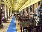 | |
| Blackie House | North Bank Street and Wardrop's Court, Old Town | 14 December 1970 | 55°57′00″N3°11′36″W / 55.949916°N 3.193276°W | Late 17th century; upper floors reconstructed S Henbest Capper 1894; shop front, 1898; further alterations, Robert Hurd, 1950. | 51522 |  | |
| Royal Lyceum Theatre | Grindlay Street | 12 December 1974 | 55°56′49″N3°12′15″W / 55.94698°N 3.204187°W | CJ Phipps, 1883. | 30031 |  | |
| 1–3 Ramsay Garden | 14 December 1970 | 55°56′58″N3°11′47″W / 55.949373°N 3.196494°W | Early 18th century, and Arthur George Sydney Mitchell and George Wilson, 1894. | 29593 |  | ||
| 4–10 Ramsay Garden | 14 December 1970 | 55°56′58″N3°11′47″W / 55.949373°N 3.196494°W | 1733-4 (Ramsay Lodge) with alterations and additions, principally Arthur George Sydney Mitchell and George Wilson, 1893. | 29594 |  | ||
| 11 and 12 Ramsay Garden | 14 December 1970 | 55°56′57″N3°11′49″W / 55.949244°N 3.196843°W | Stewart Henbest Capper, 1893. | 29595 |  | ||
| Patrick Geddes Hall (Part) | 1 Mound Place | 14 December 1970 | 55°56′59″N3°11′45″W / 55.949595°N 3.195845°W | Late 18th century. | 29379 |  | |
| Patrick Geddes Hall (Part) | 2 Mound Place | 14 December 1970 | 55°56′59″N3°11′45″W / 55.949614°N 3.195701°W | Late 18th century. | 29380 |  | |
| 11, 12 and 13 North Bank Street | 14 December 1970 | 55°56′59″N3°11′38″W / 55.949802°N 3.194009°W | 1723-7, with later alterations and additions. | 29236 |  | ||
| Dolphin House | 3, 4 and 5 Hunter Square | 14 December 1970 | 55°56′59″N3°11′18″W / 55.949749°N 3.188339°W | John Baxter, 1788-90. | 29123 |  | |
| Former Skinner's Hall | 2–4 New Skinner's Close | 14 December 1970 | 55°56′59″N3°11′07″W / 55.949732°N 3.185408°W | 1643 with later additions. | 28325 |  | |
| Bank of Scotland | 11 Bank Street | 14 December 1970 | 55°57′01″N3°11′35″W / 55.950323°N 3.193033°W | Richard Crichton and Robert Reid, 1801-6, remodelled and enlarged by David Bryce 1863; alterations by Peddie and Kinnear, 1878. | 28263 | 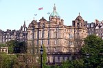 | |
| 17–20 Bank | 14 December 1970 | 55°56′59″N3°11′35″W / 55.949756°N 3.193143°W | Late 17th century, with later alterations and additions, including Henry Kerr, 1895. | 28264 | Upload Photo | ||
| 15 North Bank Street | 14 December 1970 | 55°56′59″N3°11′40″W / 55.949781°N 3.194313°W | 1723-7, with alterations by Sydney Mitchell and Wilson, 1901. | 28265 | 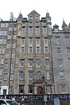 | ||
| 16 North Bank Street | 14 December 1970 | 55°56′59″N3°11′40″W / 55.949689°N 3.194454°W | David Cousin, 1859-63, probably incorporating earlier fabric. | 28266 | 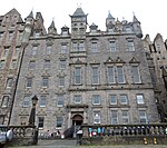 | ||
| Abbey Sanctuary | Abbey Strand | 14 December 1970 | 55°57′10″N3°10′26″W / 55.952861°N 3.173892°W | Early 16th century with 17th century and later additions and alterations. | 28207 |  | |
| Thompson's Court | Abbey Strand | 14 December 1970 | 55°57′10″N3°10′27″W / 55.952868°N 3.174165°W | Early 16th century origins with series of later additions and alterations. | 28208 |  | |
| Sacred Heart Church (Roman Catholic) | 28 Lauriston Street | 14 December 1970 | 55°56′42″N3°12′05″W / 55.945137°N 3.20152°W | Father Richard Vaughan, 1860, with some later alterations. | 27266 |  | |
| Charles II Statue | Parliament Square | 14 December 1970 | 55°56′57″N3°11′26″W / 55.949233°N 3.190533°W | Statue 1685; pedestal 1835, incorporating 1685 inscription tablet. | 27851 |  | |
| Calton Old Burial Ground and Monuments | Regent Road | 19 April 1966 | 55°57′15″N3°11′10″W / 55.954056°N 3.186149°W | Established 1718. | 27920 |  | |
| 11–15 Cornwall Street | 14 December 1970 | 55°56′50″N3°12′12″W / 55.947122°N 3.203455°W | Sir James Gowans, 1868-70. | 47858 |  | ||
| 13–16 Ramsay Garden | 14 December 1970 | 55°56′57″N3°11′48″W / 55.949092°N 3.196726°W | Stewart Henbest Capper, 1892. | 48247 |  | ||
| 1–6 India Buildings | Victoria Street | 14 December 1970 | 55°56′55″N3°11′35″W / 55.948517°N 3.193089°W | David Cousin, 1864-6. | 29868 |  | |
| Burns Monument | Regent Road | 19 April 1966 | 55°57′12″N3°10′42″W / 55.953457°N 3.178347°W | Thomas Hamilton, 1830. | 27801 |  | |
| 25 Castle Terrace and 17 Cornwall Street | 14 December 1970 | 55°56′50″N3°12′12″W / 55.947122°N 3.203455°W | Sir James Gowans, 1868-70 (dated 1868). | 28485 | 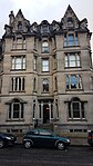 |
The A71 is a major road in Scotland linking Edinburgh with Lanarkshire and Ayrshire. It adjoins the Livingston Bypass A899.

The A702 is a major road in Scotland, that runs from Edinburgh to St. John's Town of Dalry in Dumfries and Galloway. It is the last section of the route from London via the West Midlands and North West England to Edinburgh, which follows the M1, M6, A74(M) and finally the A702.

Abbeyhill is an area of Edinburgh, the capital of Scotland.
Tollcross is a major road junction to the south west of the city centre of Edinburgh, Scotland which takes its name from a local historical land area.

The West Port is a street in Edinburgh's Old Town, just south of Edinburgh Castle. It runs from Main Point to the southwest corner of the Grassmarket.

The A700 road is a short but important link skirting Edinburgh City Centre between the A8 and A7 roads.

There have been several town walls around Edinburgh, Scotland, since the 12th century. Some form of wall probably existed from the foundation of the royal burgh in around 1125, though the first building is recorded in the mid-15th century, when the King's Wall was constructed. In the 16th century the more extensive Flodden Wall was erected, following the Scots' defeat at the Battle of Flodden in 1513. This was extended by the Telfer Wall in the early 17th century. The walls had a number of gates, known as ports, the most important being the Netherbow Port, which stood halfway down what is now the Royal Mile. This gave access from the Canongate which was, at that time, a separate burgh.
The West End is an affluent district of Edinburgh, Scotland, which along with the rest of the New Town and Old Town forms central Edinburgh, and Edinburgh's UNESCO World Heritage Site. The area boasts several of the city's hotels, restaurants, independent shops, offices and arts venues, including the Edinburgh Filmhouse, Edinburgh International Conference Centre and the Caledonian Hotel. The area also hosts art festivals and crafts fairs.