List of Christopher Wren churches in London

Last updated

Tribute to the memory of Sir Christopher Wren by Charles Robert Cockerell, showing an array of Wren's churches from around London imagined together Etching based on "Tribute to the memory of Sir Christopher Wren".jpg
Tribute to the memory of Sir Christopher Wren by Charles Robert Cockerell, showing an array of Wren's churches from around London imagined together

Sir Christopher Wren was 33 years old and near the beginning of his career as an architect when the Great Fire of London in 1666 destroyed many of the city's public buildings, including 88 of its parish churches. Wren's office was commissioned to build 51 replacement churches and St Paul's Cathedral. Many of these buildings survive to this day; others have been substantially altered or rebuilt. Some others were completely or partially destroyed during the German Blitz of 1940–41; others were demolished for different reasons.

Contents

Churches in the City of London

Many of Wren's churches were demolished as the population of the City of London declined in the 19th century and more were destroyed or damaged during the Blitz.

Survived in original form

ImageNameLocationDateListingCoordinates
St Benet Paul's Wharf, Queen Victoria Street, London EC4 - geograph.org.uk - 1202624.jpg St Benet Paul's Wharf Queen Victoria Street, Queenhithe, City of London 1677–83Grade I (1950) 51°30′42.01″N0°5′57.38″W / 51.5116694°N 0.0992722°W / 51.5116694; -0.0992722
St Clement's Church, Clement's Lane, London EC4 - geograph.org.uk - 1062087.jpg St Clement Eastcheap Clement's Lane, Candlewick, City of London 1683–87Grade I (1950) 51°30′40.77″N0°5′12.81″W / 51.5113250°N 0.0868917°W / 51.5113250; -0.0868917
St Edmund the King and Martyr, Lombard Street, London EC3 - geograph.org.uk - 1084869.jpg St Edmund, King and Martyr Lombard Street, Langbourn, City of London 1670–79Grade I (1950) 51°30′44.62″N0°5′10.68″W / 51.5123944°N 0.0863000°W / 51.5123944; -0.0863000
St James Garlickhythe Church, Garlick Hill, London EC4 - geograph.org.uk - 1085159.jpg St James Garlickhythe Garlick Hill, Vintry, City of London 1676–83Grade I (1950) 51°30′39.99″N0°5′37.54″W / 51.5111083°N 0.0937611°W / 51.5111083; -0.0937611
St Margaret, Lothbury, London EC2 - geograph.org.uk - 1197730.jpg St Margaret Lothbury Lothbury, Coleman Street Ward and Broad Street Ward, City of London 1686–90Grade I (1950) 51°30′52.91″N0°5′19.92″W / 51.5146972°N 0.0888667°W / 51.5146972; -0.0888667
St Margaret Pattens, Eastcheap, London EC3 - geograph.org.uk - 1077034.jpg St Margaret Pattens Eastcheap, Billingsgate, City of London 1684–87Grade I (1950) 51°30′38.75″N0°4′58.74″W / 51.5107639°N 0.0829833°W / 51.5107639; -0.0829833
St Martin, Ludgate Hill, London EC4 - geograph.org.uk - 1196972.jpg St Martin, Ludgate Ludgate Hill, Farringdon Within, City of London 1677–84Grade I (1950) 51°30′50.55″N0°6′6.99″W / 51.5140417°N 0.1019417°W / 51.5140417; -0.1019417
St Mary Abchurch, Abchurch Lane, London EC4 - Spire - geograph.org.uk - 1067745.jpg St Mary Abchurch Abchurch Lane, Candlewick, City of London 1681–86Grade I (1950) 51°30′42.02″N0°5′18.05″W / 51.5116722°N 0.0883472°W / 51.5116722; -0.0883472
City parish churches, St. Mary Aldermary (rear view) - geograph.org.uk - 560482.jpg St Mary Aldermary Queen Victoria Street, Cordwainer, City of London 1679–82Grade I (1950) 51°30′46″N0°05′36″W / 51.51278°N 0.09333°W / 51.51278; -0.09333
St Michael, Cornhill, London EC3 - Tower - geograph.org.uk - 1077409.jpg St Michael's Cornhill Cornhill, Cornhill, City of London 1669–72Grade I (1950) 51°30′47.50″N0°5′7.68″W / 51.5131944°N 0.0854667°W / 51.5131944; -0.0854667
St Paul's - geograph.org.uk - 1013223.jpg St Paul's Cathedral St Paul's Churchyard, Castle Baynard, City of London 1675-1711Grade I (1950) 51°30′49″N0°05′53″W / 51.51361°N 0.09806°W / 51.51361; -0.09806
St Peter upon Cornhill, Cornhill, London EC3 - geograph.org.uk - 1767455.jpg St Peter upon Cornhill Cornhill, Cornhill, City of London 1677–84Grade I (1950) 51°30′47.7″N0°5′4.5″W / 51.513250°N 0.084583°W / 51.513250; -0.084583
St Stephen Walbrook1.jpg St Stephen Walbrook Walbrook, Walbrook, City of London 1672–79Grade I (1950) 51°30′45.46″N0°5′23.71″W / 51.5126278°N 0.0899194°W / 51.5126278; -0.0899194

Substantially altered before the Blitz

ImageNameLocationDateListingCommentCoordinates
Flickr - Duncan~ - St Magnus vs The Shard.jpg St Magnus-the-Martyr Lower Thames Street, Bridge, City of London 1671–87Grade I (1950)altered after London Bridge was widened in 1762 51°30′33.41″N0°5′10.81″W / 51.5092806°N 0.0863361°W / 51.5092806; -0.0863361
St Mary at Hill, St Mary at Hill, Cheapside, London EC3 - geograph.org.uk - 717975.jpg St Mary-at-Hill Lovat Lane, Billingsgate, City of London 1670–76Grade I (1950)altered in 1787–88 and 1826–27 51°30′36″N0°05′01″W / 51.510069°N 0.08374°W / 51.510069; -0.08374

Substantially rebuilt after the Blitz

The Blitz in 1940–1941 damaged nearly all the churches in the City of London and many were nearly destroyed leaving just the outer walls and tower. However most of them were rebuilt to Wren's original design.

ImageNameLocationDateListingCommentCoordinates
St Andrew-by-the-Wardrobe Tower - geograph.org.uk - 1172752.jpg St Andrew-by-the-Wardrobe Queen Victoria Street, Castle Baynard, City of London 1685–95Grade I (1950)rededicated in 1961 51°30′44.44″N0°6′4.89″W / 51.5123444°N 0.1013583°W / 51.5123444; -0.1013583
St Andrew's Church, St Andrew Street EC1 - geograph.org.uk - 1274102.jpg St Andrew, Holborn Holborn Viaduct, Farringdon Without, City of London 1686–87Grade I (1950)re-opened in 1961 51°31′2.10″N0°6′24.14″W / 51.5172500°N 0.1067056°W / 51.5172500; -0.1067056
The tower of the Church of St. Anne and St. Agnes - geograph.org.uk - 1137533.jpg St Anne and St Agnes Gresham Street, Aldersgate, City of London 1676–87Grade I (1950)rededicated in 1966 51°30′59″N0°5′47″W / 51.51639°N 0.09639°W / 51.51639; -0.09639
St Bride, Fleet Street, London EC4 - geograph.org.uk - 1213683.jpg St Bride's Church Fleet Street, Castle Baynard, City of London 1670–84Grade I (1950)rededicated in 1957 51°30′50″N0°6′21″W / 51.51389°N 0.10583°W / 51.51389; -0.10583
St Lawrence Jewry, Gresham Street, London EC2 - geograph.org.uk - 1208656.jpg St Lawrence Jewry Gresham Street, Cheap, City of London 1670–86Grade I (1950)restored in 1957 51°30′55″N0°05′33″W / 51.5152°N 0.0925°W / 51.5152; -0.0925
The Church of St. Mary-le-Bow, Cheapside, EC2 - geograph.org.uk - 1137446.jpg St Mary-le-Bow Cheapside, Cordwainer, City of London 1670–83Grade I (1950)reconsecrated in 1964 51°30′50″N0°05′37″W / 51.51389°N 0.09361°W / 51.51389; -0.09361
City parish churches, St. Michael (Paternoster) Royal - geograph.org.uk - 491255.jpg St Michael Paternoster Royal College Hill, Dowgate, City of London 1686–94Grade I (1950)restored in 1966–8 51°30′40.22″N0°5′31.76″W / 51.5111722°N 0.0921556°W / 51.5111722; -0.0921556
City parish churches, St. Nicholas Cole Abbey - geograph.org.uk - 491083.jpg St Nicholas Cole Abbey Queen Victoria Street, Bread Street Ward, City of London 1671–81Grade I (1950)reconsecrated in 1962 51°30′43″N0°5′48″W / 51.51194°N 0.09667°W / 51.51194; -0.09667
St Vedast Foster Lane.jpg St Vedast Foster Lane Foster Lane, Cheap, City of London 1670–97Grade I (1950)restored by 1962 51°30′53.56″N0°5′46.08″W / 51.5148778°N 0.0961333°W / 51.5148778; -0.0961333

Tower remaining

These churches were destroyed in the Blitz or demolished in the 19th century. Only their towers remained with perhaps a short section of the outer wall. They are no longer working churches.

ImageNameLocationDateListingCommentCoordinates
Mary somerset godwin.jpg St Mary Somerset Upper Thames Street, Queenhithe, City of London 1686–94Grade I (1950)Body of the church demolished in 1871. Tower surrounded by small garden 51°30′40.92″N0°5′48.80″W / 51.5113667°N 0.0968889°W / 51.5113667; -0.0968889
Olave oldjewry godwin.jpg St Olave Old Jewry Ironmonger Lane, Walbrook, City of London 1670–79Grade I (1950)Body of the church was demolished in 1887. Tower is part of an office building. 51°30′52.15″N0°5′28.70″W / 51.5144861°N 0.0913056°W / 51.5144861; -0.0913056
Christchurch newgate godwin.jpg Christ Church Greyfriars Newgate Street, Farringdon Within, City of London 1677–91Grade I (1950)Destroyed in the Blitz. The ruins are a public garden, the tower is private residence 51°30′56.94″N0°5′56.93″W / 51.5158167°N 0.0991472°W / 51.5158167; -0.0991472
Alban wood godwin.jpg St Alban's, Wood Street Wood Street, Bassishaw, City of London 1682–87Grade II (1950)Destroyed in the Blitz. The tower is private dwelling 51°30′59.69″N0°5′38.95″W / 51.5165806°N 0.0941528°W / 51.5165806; -0.0941528
Augustine watling godwin.jpg St Augustine Watling Street Watling Street, Bread Street Ward, City of London 1680–87Grade I (1950)Destroyed in the Blitz. Tower part of St Paul's Cathedral Choir School 51°30′48.52″N00°05′49.00″W / 51.5134778°N 0.0969444°W / 51.5134778; -0.0969444
Dunsten east godwin.jpg St Dunstan-in-the-East St Dunstan's Hill, Billingsgate, City of London 1698Grade I (1950)Rebuilt in 1817–21, but destroyed in the Blitz. Ruins are a public garden 51°30′34.82″N0°4′57.80″W / 51.5096722°N 0.0827222°W / 51.5096722; -0.0827222

Stones re-used

ImageNameLocationDateListingCommentCoordinates
Hallows lombard godwin.jpg All Hallows Lombard Street Lombard Street, Langbourn, City of London 1686–94never listedDemolished in 1939, with the tower and interior fittings moved to All Hallows Twickenham 51°30′39.09″N0°5′5.84″W / 51.5108583°N 0.0849556°W / 51.5108583; -0.0849556
Mary aldermanbury godwin.jpg St Mary Aldermanbury Aldermanbury, Bassishaw, City of London 1670–74Grade II (1972)Ruined in 1940, and the stones transported to Fulton, Missouri in 1964. Rebuilt as a memorial to Sir Winston Churchill 51°30′59.34″N0°5′35.06″W / 51.5164833°N 0.0930722°W / 51.5164833; -0.0930722

Demolished due to the Union of Benefices Act (chronological order)

The population of the City of London declined sharply in the 19th century, and the Union of Benefices Act 1860 reduced the number of parish churches. The surplus churches were demolished.

ImageNameLocationDateCommentCoordinates
Benet gracechurch godwin.jpg St Benet Gracechurch Gracechurch Street, Bridge, City of London 1681–87demolished in 1868 51°30′42″N0°5′6″W / 51.51167°N 0.08500°W / 51.51167; -0.08500
Mildred poultry godwin.jpg St Mildred, Poultry Poultry, Walbrook, City of London1670–77demolished in 1872 51°30′49″N0°5′24″W / 51.51361°N 0.09000°W / 51.51361; -0.09000
St antholin godwin.jpg St Antholin, Budge Row Watling Street, Cordwainer, City of London 1678–84demolished in 1875 51°30′45″N0°05′31″W / 51.51250°N 0.09194°W / 51.51250; -0.09194
Michael queenhithe godwin.jpg St Michael Queenhithe Upper Thames Street, Queenhithe, City of London 1676–86demolished in 1876 51°30′40″N0°5′42″W / 51.51111°N 0.09500°W / 51.51111; -0.09500
Hallows bread godwin.jpg All Hallows Bread Street Bread Street, Cordwainer, City of London 1681–98demolished in 1878 51°30′47″N0°05′42″W / 51.5131°N 0.0951°W / 51.5131; -0.0951
Dionis backchurch godwin.jpg St Dionis Backchurch Fenchurch Street, Langbourn, City of London 1670–77demolished in 1878 51°30′43″N0°5′2″W / 51.51194°N 0.08389°W / 51.51194; -0.08389
Matthew friday godwin.jpg St Matthew Friday Street Friday Street, Bread Street Ward, City of London 1682–85demolished in 1885 51°30′49″N0°5′44″W / 51.51361°N 0.09556°W / 51.51361; -0.09556
Magdalen fish godwin.jpg St Mary Magdalen Old Fish Street Old Change, Bread Street, City of London 1683–87demolished in 1893 51°30′45″N0°5′51″W / 51.51250°N 0.09750°W / 51.51250; -0.09750
Hallows great godwin.jpg All-Hallows-the-Great Upper Thames Street, Dowgate, City of London 1677–84demolished in 1894 51°30′36″N0°05′25″W / 51.5100°N 0.0902°W / 51.5100; -0.0902
Michael woodstreet godwin.jpg St Michael Wood Street Wood Street, Cripplegate, City of London 1670–75demolished in 1897 51°30′56″N0°5′41.5″W / 51.51556°N 0.094861°W / 51.51556; -0.094861

Demolished for other reasons (chronological order)

ImageNameLocationDateDemolitionReasonCoordinates
Christopher le stocks.jpg St Christopher le Stocks Threadneedle Street, Walbrook, City of London 1670–71demolished in 1782to provide space for the extension of the Bank of England 51°30′51″N0°05′19″W / 51.5141°N 0.0886°W / 51.5141; -0.0886
Michael crooked lane.jpg St Michael, Crooked Lane Miles's Lane, Candlewick, City of London 1687demolished in 1831wider approaches were needed for the rebuilt London Bridge 51°30′39″N0°05′14″W / 51.51070°N 0.087280°W / 51.51070; -0.087280
St Bartholomews by the Exchange Exterior.jpg St Bartholomew-by-the-Exchange Bartholomew Lane, Walbrook, City of London 1675–83demolished in 1840to provide space for the widening of Threadneedle Street 51°30′50″N0°05′14″W / 51.51376°N 0.0873°W / 51.51376; -0.0873
Benet fink godwin.jpg St Benet Fink Threadneedle Street, Cornhill, City of London 1670–75demolished between 1841 and 1846to improve the site of the Royal Exchange 51°30′50″N0°5′10″W / 51.51389°N 0.08611°W / 51.51389; -0.08611
Michael bassishaw godwin.jpg St Michael Bassishaw Basinghall Street, Bassishaw, City of London 1675–79demolished in 1900judged structurally unsafe in 1892 51°31′0.1″N0°5′30″W / 51.516694°N 0.09167°W / 51.516694; -0.09167
George botolph godwin.jpg St George Botolph Lane Botolph Lane, Bridge, City of London 1671–76demolished in 1904judged structurally unsafe and closed 1901 51°30′38″N0°5′7″W / 51.51056°N 0.08528°W / 51.51056; -0.08528

Destroyed in the Blitz

These churches were destroyed in the Blitz and their ruins demolished afterwards.

ImageNameLocationDateDemolitionCoordinates
Stephen coleman godwin.jpg St Stephen Coleman Street Coleman Street, Coleman Street Ward, City of London 16771940 51°30′56″N0°05′25″W / 51.5155°N 0.0904°W / 51.5155; -0.0904
Mildred bread godwin.jpg St Mildred, Bread Street Bread Street, Vintry, City of London 1677–831941 51°30′44″N0°05′43″W / 51.5123°N 0.0952°W / 51.5123; -0.0952
Swithin londonstone godwin.jpg St Swithin, London Stone Cannon Street, Walbrook, City of London 16781962 51°30′42″N0°5′22″W / 51.51167°N 0.08944°W / 51.51167; -0.08944

Interior refurbished by Christopher Wren

ImageNameLocationDateListingCommentCoordinates
Temple reredos godwin.jpg Temple Church Fleet Street, Farringdon Without, City of London 1682–83Grade I (1950)During the restoration after the Blitz Wren's wooden altar was discovered in a museum and was restored to its original position 51°30′47.52″N0°06′37.44″W / 51.5132000°N 0.1104000°W / 51.5132000; -0.1104000

Churches built outside the City of London

These churches were outside the area of the Great Fire of London.

ImageNameLocationDateListingCommentCoordinates
Annes soho harrison.jpg St Anne's Church, Soho Dean Street, Soho, City of Westminster 1677–85Grade II (1958)The body of the church by Wren and William Talman was destroyed in the Blitz and later totally demolished; the preserved tower was built by S. P. Cockerell in 1801–03 51°30′45″N0°07′56″W / 51.5124°N 0.1323°W / 51.5124; -0.1323
St. Clement Danes te Londen The south Prospect of the Church of St. Clement Danes - London (titel op object), RP-P-1910-2126 (cropped).jpg St Clement Danes Strand, City of Westminster 1680–82Grade I (1958)Destroyed in 1941; reconsecrated in 1958 after the Blitz. 51°30′47″N0°06′50″W / 51.513107°N 0.113898°W / 51.513107; -0.113898
Church of St Jamess Piccadilly (5123795031).jpg St James's Church, Piccadilly Piccadilly, St James's, City of Westminster 1676–84Grade I (1958)Destroyed in 1940; restored in 1947–54 after the Blitz 51°30′31″N0°8′12″W / 51.50861°N 0.13667°W / 51.50861; -0.13667
The Chapel2, Royal Hospital, Chelsea.jpg Chapel of the Royal Hospital Chelsea Royal Hospital Road, Chelsea, Royal Borough of Kensington and Chelsea 1682–87Grade I (1969)Wren designed the rest of the Hospital, as well. 51°29′11″N0°9′28″W / 51.48639°N 0.15778°W / 51.48639; -0.15778

See also

Bibliography

Related Research Articles

<span class="mw-page-title-main">St Mary-le-Bow</span> Church in Cheapside, City of London

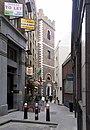
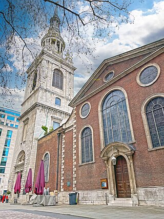
The Church of St Mary-le-Bow is a Church of England parish church in the City of London, England. Located on Cheapside, one of the city's oldest thoroughfares, the church was founded in 1080, by Lanfranc, Archbishop of Canterbury. Rebuilt several times over the ensuing centuries, the present church is the work of Sir Christopher Wren, following the Great Fire of London (1666). With its tall spire, it is still a landmark in the City of London, being the third highest of any Wren church, surpassed only by nearby St Paul's Cathedral and St Bride's, Fleet Street. At a cost of over £15,000, it was also his second most expensive, again only surpassed by St Paul's Cathedral.

<span class="mw-page-title-main">St Anne and St Agnes</span> Church in London, England

<span class="mw-page-title-main">St Dunstan-in-the-East</span> Church in London, England

St Dunstan-in-the-East was a Church of England parish church on St Dunstan's Hill, halfway between London Bridge and the Tower of London in the City of London. The church was largely destroyed in the Second World War and the ruins are now a public garden.

<span class="mw-page-title-main">Christ Church Greyfriars</span> Church in the City of London, United Kingdom

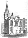
Christ Church Greyfriars, also known as Christ Church Newgate Street, was a church in Newgate Street, opposite St Paul's Cathedral in the City of London. Established as a monastic church in the thirteenth century, it became a parish church after the Dissolution of the Monasteries. Following its destruction in the Great Fire of London of 1666, it was rebuilt to the designs of Sir Christopher Wren. Except for the tower, the church was largely destroyed by bombing during the Second World War. The decision was made not to rebuild the church; the ruins are now a public garden.

<span class="mw-page-title-main">St Mary Aldermary</span> Church in London, England

St Mary Aldermary, is an Anglican guild church located on Bow Lane at the junction with Watling St, in the City of London. Of medieval origin, rebuilding began under the Tudor Henry VIII in 1510 and was not finished until the reign of the Stuart monarch Charles I in 1632. Severely damaged just 33 years later during the Great Fire of London in 1666, it was rebuilt once more, this time by the office of Sir Christopher Wren. Unlike most of Wren's City churches, St Mary Aldermary was reconstructed in the Gothic style, an outstanding example of the first — 17th century — Gothic Revival. Nearly a millennium after its foundation SMA continues to offer a place for contemplation with pre-work 8am gatherings three times a week and after work at 6pm on Wednesday.

<span class="mw-page-title-main">St James Garlickhythe</span> Church in City of London, England

St James Garlickhythe is a Church of England parish church in Vintry ward of the City of London, nicknamed "Wren's lantern" owing to its profusion of windows.

<span class="mw-page-title-main">St Alban, Wood Street</span> Former church in London

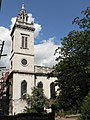
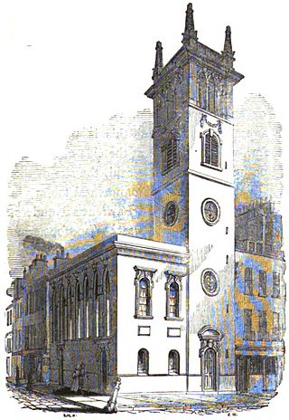
St Alban's was a church in Wood Street, City of London. It was dedicated to Saint Alban. Of medieval origin, it was rebuilt in 1634, destroyed in the Great Fire of London in 1666, and rebuilt, this time to a Gothic design by Sir Christopher Wren. It was severely damaged by bombing during the Second World War and the ruins cleared, leaving only the tower.

<span class="mw-page-title-main">St Mary Somerset</span> Former church in London

St. Mary Somerset was a church in the City of London first recorded in the twelfth century. Destroyed in the Great Fire of 1666, it was one of the 51 churches rebuilt by the office of Sir Christopher Wren. The tower is located in Upper Thames Street, the body of the church being demolished in 1871.

<span class="mw-page-title-main">St Michael Queenhithe</span> Former church in London

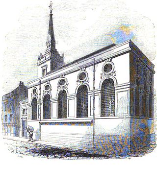
St. Michael Queenhithe was a church in the City of London located in what is now Upper Thames Street. First recorded in the 12th century, the church was destroyed during the Great Fire of London in 1666. Rebuilt by the office of Sir Christopher Wren, it was demolished in 1876.

<span class="mw-page-title-main">All Hallows, Bread Street</span> Church in London, England

All Hallows Bread Street was a parish church in the Bread Street ward of the City of London, England. It stood on the east side of Bread Street, on the corner with Watling Street. First mentioned in the 13th century, the church was destroyed in the Great Fire of London in 1666. The church was rebuilt by the office of Sir Christopher Wren and demolished in 1876.

<span class="mw-page-title-main">All-Hallows-the-Great</span> Church in London, England

All-Hallows-the-Great was a church in the City of London, located on what is now Upper Thames Street, first mentioned in 1235. Destroyed in the Great Fire of London of 1666, the church was rebuilt by the office of Sir Christopher Wren. All-Hallows-the-Great was demolished in 1894 when many bodies were disinterred from the churchyard and reburied at Brookwood Cemetery.

<span class="mw-page-title-main">St Stephen Coleman Street</span> Church in London, England

St. Stephen's Church, Coleman Street, also called "St Stephen's in the Jewry", was a church in the City of London, at the corner of Coleman Street and what is now Gresham Street, first mentioned in the 12th century. In the middle ages it is variously described as a parish church, and as a chapel of ease to the church of St Olave Old Jewry; its parochial status was defined permanently in 1456.

<span class="mw-page-title-main">St Olave's Church, Old Jewry</span> Former church-site in London

St Olave's Church, Old Jewry, sometimes known as Upwell Old Jewry, was a church in the City of London located between the street called Old Jewry and Ironmonger Lane. Destroyed in the Great Fire of London in 1666, the church was rebuilt by the office of Sir Christopher Wren. The church was demolished in 1887, except for the tower and west wall, which remain today.

<span class="mw-page-title-main">St Bartholomew-by-the-Exchange</span> Church in London, England

St. Bartholomew-by-the-Exchange was a church and parish in the City of London located on Bartholomew Lane, off Threadneedle Street. Recorded since the 13th century, the church was destroyed in the Great Fire of London in 1666, then rebuilt by Sir Christopher Wren. The rebuilt church was demolished in 1840.

<span class="mw-page-title-main">St Benet Gracechurch</span> Church in London, England

St Benet Gracechurch, so called because a haymarket existed nearby (Cobb), was a parish church in the City of London. First recorded in the 11th century, it was destroyed in the Great Fire of London of 1666 and rebuilt by the office of Sir Christopher Wren. The church was demolished in 1868.

<span class="mw-page-title-main">St Benet Fink</span> Church in London, England

St Benet Fink was a church and parish in the City of London located on what is now Threadneedle Street. Recorded since the 13th century, the church was destroyed in the Great Fire of London of 1666, then rebuilt to the designs of Sir Christopher Wren. The Wren church was demolished between 1841 and 1846.

<span class="mw-page-title-main">St Michael Bassishaw</span> Church in London, England

St Michael Bassishaw, or Basinshaw, was a parish church in Basinghall Street in the City of London, standing on land now occupied by the Barbican Centre complex. Recorded since the 12th century, the church was destroyed in the Great Fire of 1666, then rebuilt by the office of Sir Christopher Wren. The rebuilt church was demolished in 1900.

<span class="mw-page-title-main">St Mary Magdalen Old Fish Street</span> Former church-site in London

St. Mary Magdalen Old Fish Street was a church in Castle Baynard ward of the City of London, England, located on the corner of Old Fish Street and Old Change, on land now covered by post-War development. Recorded since the 12th century, the church was destroyed in the Great Fire of London of 1666, then rebuilt by the office of Sir Christopher Wren. The rebuilt church suffered damage to its roof from a fire in an adjacent warehouse in 1886. It was not repaired, and was finally demolished in 1893.

<span class="mw-page-title-main">St Swithin, London Stone</span> Church in London, England

St Swithin, London Stone, was an Anglican Church in the City of London. It stood on the north side of Cannon Street, between Salters' Hall Court and St Swithin's Lane, which runs north from Cannon Street to King William Street and takes its name from the church. Of medieval origin, it was destroyed by the Great Fire of London, and rebuilt to the designs of Sir Christopher Wren. It was badly damaged by bombing during the Second World War, and the remains were demolished in 1962.

<span class="mw-page-title-main">St Christopher le Stocks</span> Church in London, England