
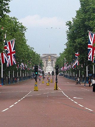
The Mall is a ceremonial route and roadway in the City of Westminster, central London, that travels 1 kilometre (0.62 mi) between Buckingham Palace at its western end and Trafalgar Square via Admiralty Arch to the east. Along the north side of The Mall is green space and St. James's Palace with other official buildings, and to the south is St James's Park. Near the east end at Trafalgar Square and Whitehall it is met by Horse Guards Road and Spring Gardens, near the west end at the Victoria Memorial it is met by the Constitution Hill roadway and the Spur Road to the street of Buckingham Gate. It is closed to traffic on Saturdays, Sundays, public holidays and on ceremonial occasions.

Walbrook is a Ward of the City of London and a minor street in its vicinity. The ward is named after a river of the same name.
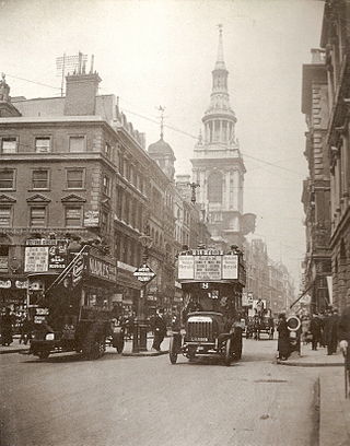
Cheapside is a street in the City of London, the historic and modern financial centre of London, England, which forms part of the A40 London to Fishguard road. It links St Martin's Le Grand with Poultry. Near its eastern end at Bank Junction, where it becomes Poultry, is Mansion House, the Bank of England, and Bank station. To the west is St Paul's Cathedral, St Paul's tube station and square.

Cannon Street is a road in the City of London, the historic nucleus of London and its modern financial centre. It runs roughly parallel with the River Thames, about 250 metres (820 ft) north of it, in the north of the City.

Gracechurch Street is a main road in the City of London, the historic and financial centre of London, England, which is designated the A1213.

Eastcheap is a street in central London that is a western continuation of Great Tower Street towards Monument junction. Its name derives from cheap, the Old English word for market, with the prefix 'East' distinguishing it from Westcheap, another former market street that today is called Cheapside.

St Andrew-by-the-Wardrobe is a Church of England church located on Queen Victoria Street, London in the City of London, near Blackfriars station.

Baynard's Castle refers to buildings on two neighbouring sites in the City of London, between where Blackfriars station and St Paul's Cathedral now stand. The first was a Norman fortification constructed by Ralph Baynard, 1st feudal baron of Little Dunmow in Essex, and was demolished by King John in 1213. The second was a medieval palace built a short distance to the south-east and later extended, but mostly destroyed in the Great Fire of London in 1666. According to Sir Walter Besant, "There was no house in [London] more interesting than this".

Fenchurch Street is a street in London, England, linking Aldgate at its eastern end with Lombard Street and Gracechurch Street in the west. It is a well-known thoroughfare in the City of London financial district and is the site of many corporate offices and headquarters. The name "Fenchurch" means "church in the fenny or marshy ground" and presumably refers to St Gabriel Fenchurch, which stood at the junction of Fenchurch Street and Cullum Street until it was destroyed by the Great Fire.

Cornhill is a ward and street in the City of London, the historic nucleus and financial centre of modern London, England. The street runs between Bank Junction and Leadenhall Street.
Montfichet's Tower was a Norman fortress on Ludgate Hill in London, between where St Paul's Cathedral and City Thameslink railway station now stand. First documented in the 1130s, it was probably built in the late 11th century. The defences were strengthened during the revolt of 1173–1174 against Henry II.

Gresham Street in the City of London is named after the English merchant and financier Thomas Gresham.
Bread Street is one of the 26 wards of the City of London, the name deriving from its principal street, which was anciently the city's bread market; already named Bredstrate for by the records it appears as that in 1302, Edward I announced that "the bakers of Bromley and Stratford-le-Bow [London], and ones already living on the street, were forbidden from selling bread from their own homes or bakeries, and could only do so from Bread Street." The street itself is just under 500 ft in length and now forms the eastern boundary of the ward after the 2003 boundary changes.

The Faraday Building is in the south-west of the City of London. The land was first acquired by the General Post Office in the 1870s, for the Post Office Savings Bank. In 1902 it was converted to a GPO telephone exchange serving sections of London, and underwent several capacity expansions over the next several years. The eastern extension of the building stands on the site of Doctors' Commons whose members had lower-courts say in ecclesiastical and admiralty matters.

Lime Street is a minor road in the City of London between Fenchurch Street to the south and Leadenhall Street to the north. Its name comes from the lime burners who once sold lime from there for use in construction.

Queenhithe is a small and ancient ward of the City of London, situated by the River Thames and to the south of St. Paul's Cathedral. The Millennium Bridge crosses into the City at Queenhithe.

Byward Street is a road in the City of London, the historic and financial centre of London. It forms part of the A3211 route and, if travelling eastward, is a short continuation of Lower Thames Street from a junction with Great Tower Street, to Tower Hill. It is located within the City ward of Tower.
The 2012 Olympic Marathon Course is that of both the men's and women's marathon races at the 2012 Olympic and Paralympic Games in London.

Queen Street is a street in the City of London which runs between Upper Thames Street at its southern end to Cheapside in the north. The thoroughfares of Queen Street and King Street were newly laid out, cutting across more ancient routes in the City, following the Great Fire of London in 1666; they were the only notable new streets following the fire's destruction of much of the City.
Lombard Street is a street notable for its connections with the City of London's merchant, banking and insurance industries, stretching back to medieval times.


