List of Communities of Torfaen

Last updated

Torfaen is a unitary authority in South East Wales. Torfaen includes 16 communities.

Contents

Communities in Torfaen

Torfaen UK community map numbered.svg
NamePopulationKey
on map
Abersychan [lower-alpha 1] 7,064 [1] 2
Blaenavon [lower-alpha 1] 6,055 [2] 1
Croesyceiliog [lower-alpha 2] 5,246 [3] 10
Cwmbran Central 9,947 [4] 12
Fairwater [lower-alpha 3] 11,632 [5] 11
Henllys 2,682 [6] 14
Llantarnam 4,125 [7] 15
Llanyrafon 3,239 [8] 13
New Inn [lower-alpha 1] 5,986 [9] 5
Panteg [lower-alpha 1] 7,217 [10] 7
Pen Tranch [lower-alpha 4] 5,989 [11] 3
Ponthir 1,482 [12] 16
Pontnewydd 4,954 [13] 9
Pontymoile [lower-alpha 5] 5,082 [14] 6
Trevethin [lower-alpha 6] 5,147 [15] 4
Upper Cwmbran [lower-alpha 1] 5,228 [16] 8
  1. 1 2 3 4 5 This community is also an electoral ward with the same name.
  2. Croesyceiliog community comprises the electoral wards of Croesyceiliog North and Croesyceiliog South.
  3. Fairwater community comprises the electoral wards of Coed Eva, Fairwater, and Greenmeadow.
  4. Pen Tranch community comprises the electoral wards of Pontnewynydd, Snatchwood, and Wainfelin.
  5. Pontymoile community comprises the electoral wards of Brynwern, Cwmyniscoy, and Pontypool.
  6. Trevethin community comprises the electoral wards of St Cadocs and Penygarn, and Trevethin.

See also

Related Research Articles

<span class="mw-page-title-main">Abersychan</span> Town in Wales

Abersychan is a town and community north of Pontypool in Torfaen, Wales, and lies within the boundaries of the historic county of Monmouthshire and the preserved county of Gwent.

<span class="mw-page-title-main">Cwmbran</span> Human settlement in Wales

Cwmbran is a town in the county borough of Torfaen in South Wales.

<span class="mw-page-title-main">Torfaen</span> County borough in Wales

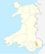
Torfaen is a county borough in the south-east of Wales. Torfaen is bordered by the county of Monmouthshire to the east, the city of Newport to the south, and the county boroughs of Caerphilly and Blaenau Gwent to the south-west and north-west. It is within the boundaries of the historic county of Monmouthshire, and between 1974 and 1996 was a district of Gwent, until it was reconstituted as a principal area in 1996.

<span class="mw-page-title-main">Pontypool</span> Human settlement in Wales

Pontypool is a town and the administrative centre of the county borough of Torfaen, within the historic boundaries of Monmouthshire in South Wales. As of 2021, it has a population of 29,062.

<span class="mw-page-title-main">Blaenavon</span> Human settlement in Wales

Blaenavon is a town and community in Torfaen county borough, Wales, high on a hillside on the source of the Afon Lwyd. It is within the boundaries of the historic county of Monmouthshire and the preserved county of Gwent. The population is 6,055.

<span class="mw-page-title-main">Croesyceiliog</span> Human settlement in Wales

Croesyceiliog is a suburb of Cwmbran, Wales.

<span class="mw-page-title-main">Pontnewydd</span> Human settlement in Wales

Pontnewydd is a suburb of Cwmbran in the county borough of Torfaen, south-east Wales. It should not be confused with Pontnewynydd in nearby Pontypool.

<span class="mw-page-title-main">Fairwater, Torfaen</span> Human settlement in Wales

Fairwater is a community and suburb of Cwmbran in the county borough of Torfaen, in south east Wales, and was built by the Cwmbran Development Corporation between 1963 and 1966.

<span class="mw-page-title-main">Llanyrafon</span> Human settlement in Wales

Llanyrafon is a suburb of Cwmbran and a community in the county borough of Torfaen in south east Wales. It lies within the boundaries of the historic county of Monmouthshire and the preserved county of Gwent.

<span class="mw-page-title-main">Llantarnam</span> Human settlement in Wales

Llantarnam is a suburban village of Cwmbran, and is a community and electoral ward in the county borough of Torfaen in south east Wales. The ward covers the same area as the community, but also includes Southville. It is equidistant from Cwmbran town centre and the town of Caerleon.

<span class="mw-page-title-main">Trevethin</span> Human settlement in Wales

Trevethin is a suburb of Pontypool and a community in Torfaen, Wales. It includes two electoral wards for Torfaen County Borough Council. It is in the historic county of Monmouthshire.

Cwmbran High School, previously known as Fairwater High School, is a state-funded and non-selective comprehensive school in the Fairwater district of Cwmbran, Torfaen, Wales.

<span class="mw-page-title-main">Pontymoile</span> Human settlement in Wales

Pontymoile is a suburb of Pontypool in Torfaen, South Wales. It is all but merged with the nearby suburbs of Cwmynyscoy and Upper Race.

<span class="mw-page-title-main">Upper Cwmbran</span> Human settlement in Wales

Upper Cwmbran is a suburb of Cwmbran, Torfaen in Wales. It lies in between the suburbs of Pontnewydd and Thornhill. It is a community and electoral ward of Torfaen County Borough Council.

<span class="mw-page-title-main">Monmouthshire County Council</span> Local government of Monmouthshire, Wales

Monmouthshire County Council is the governing body for the Monmouthshire principal area – one of the unitary authorities of Wales.

<span class="mw-page-title-main">Torfaen County Borough Council</span> Local government of Torfaen, Wales

Torfaen County Borough Council is the governing body for Torfaen, one of the Principal Areas of Wales.

<span class="mw-page-title-main">Panteg</span> Human settlement in Wales

Panteg is a large village and community in the county borough of Torfaen, Wales. It is adjacent to Griffithstown, between the towns of Cwmbran and Pontypool. The village is best known for Panteg Steel Works, which closed in 2004.

Pen Tranch is a large village and a community in Torfaen, South East Wales.

As part of the 2017 local elections in Wales on 4 May 2017, the 40 seats of Torfaen County Borough Council were up for election. There were 113 candidates. The Labour Party retained overall control of the council.

References

All population figures are from the United Kingdom Census 2011, provided by the Office for National Statistics from their Neighbourhood Statistics website www.neighbourhood.statistics.gov.uk. To see the records for a community, enter the name of the community, and select Parish as the type of area. From the topics displayed, select Census, then 2011 Census:Key Statistics, then Key Figures for 2011 Census: Key Statistics.

  1. "2011 Census, Key Figures for Abersychan". Office for National Statistics. Retrieved 25 November 2013.
  2. "2011 Census, Key Figures for Blaenavon". Office for National Statistics. Retrieved 25 November 2013.
  3. "2011 Census, Key Figures for Croesyceiliog". Office for National Statistics. Retrieved 25 November 2013.
  4. "2011 Census, Key Figures for Cwmbran Central". Office for National Statistics. Retrieved 25 November 2013.
  5. "2011 Census, Key Figures for Fairwater". Office for National Statistics. Retrieved 25 November 2013.
  6. "2011 Census, Key Figures for Henllys". Office for National Statistics. Retrieved 25 November 2013.
  7. "2011 Census, Key Figures for Llantarnam". Office for National Statistics. Retrieved 25 November 2013.
  8. "2011 Census, Key Figures for Llanyrafon". Office for National Statistics. Retrieved 25 November 2013.
  9. "2011 Census, Key Figures for New Inn". Office for National Statistics. Retrieved 25 November 2013.
  10. "2011 Census, Key Figures for Panteg". Office for National Statistics. Retrieved 25 November 2013.
  11. "2011 Census, Key Figures for Pen Tranch". Office for National Statistics. Retrieved 25 November 2013.
  12. "2011 Census, Key Figures for Ponthir". Office for National Statistics. Retrieved 25 November 2013.
  13. "2011 Census, Key Figures for Pontnewydd". Office for National Statistics. Retrieved 25 November 2013.
  14. "2011 Census, Key Figures for Pontymoile". Office for National Statistics. Retrieved 25 November 2013.
  15. "2011 Census, Key Figures for Trevethin". Office for National Statistics. Retrieved 25 November 2013.
  16. "2011 Census, Key Figures for Upper Cwmbran". Office for National Statistics. Retrieved 25 November 2013.