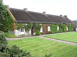
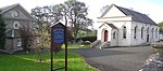
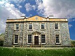
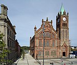
This is a list of Grade A listed buildings in County Londonderry, Northern Ireland.
In Northern Ireland, the term listed building refers to a building or other structure officially designated as being of "special architectural or historic interest". [1] Grade A structures are those considered to be "buildings of greatest importance to Northern Ireland including both outstanding architectural set-pieces and the least altered examples of each representative style, period and type." [2] Once listed, severe restrictions are imposed on the modifications allowed to a building's structure or its fittings. Listed building consent must be obtained from local authorities prior to any alteration to such a structure. [1]
Listing began later in Northern Ireland than in the rest of the UK: the first provision for listing was contained in the Planning (Northern Ireland) Order 1972; [3] and the current legislative basis for listing is the Planning (Northern Ireland) Order 1991. [2] Under Article 42 of the Order, the relevant Department of the Northern Ireland Executive is required to compile lists of buildings of "special architectural or historic interest". Since 2016, the responsibility for the listing process rests with the Historic Environment Division of the Department for Communities (DfC). [4]
Following the introduction of listing, an initial survey of Northern Ireland's building stock was begun in 1974. [5] By the time of the completion of this First Survey in 1994, the listing process had developed considerably, and it was therefore decided to embark upon a Second Survey, which is still ongoing, to update and cross-check the original information. Information gathered during this survey, relating to both listed and unlisted buildings, is entered into the publicly accessible Northern Ireland Buildings Database. [5] A range of listing criteria, which aim to define architectural and historic interest, are used to determine whether or not to list a building. [2]
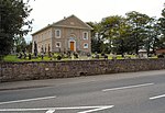
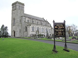
County Londonderry covers 2,074 square kilometres (801 sq mi), and has a population of around 233,500. The County has 20 Grade A listed buildings.
Building address | Grid Ref. [note 1] Geo-coordinates | Type [note 2] | Local authority | Second Survey | Original Survey | HB Number [note 3] | Image | Ref. |
---|---|---|---|---|---|---|---|---|
Mussenden Temple, Downhill, Castlerock | 55°10′04″N6°48′39″W / 55.167789°N 6.810869°W | Memorial | Coleraine | – | A | HB03/12/016 | [6] | |
Cromore House, North Ballyleese, Coleraine | 55°10′33″N6°41′47″W / 55.175825°N 6.696506°W | Country House | Coleraine | – | A | HB03/07/011 | [7] | |
Liffock House (a.k.a. Hezlett House), Liffock, Coleraine | 55°09′18″N6°47′24″W / 55.155°N 6.7899°W | Gallery/ Museum | Coleraine | A | B+ | HB03/12/028 | [8] | |
Springhill House, 20 Springhill Road, Moneymore, Magherafelt | 54°41′07″N6°39′21″W / 54.6854°N 6.6559°W | Country House | Cookstown | A | A | HB09/06/024 B | [9] | |
The Barn at Springhill, Moneymore, Magherafelt | 54°41′10″N6°39′18″W / 54.6862°N 6.655°W | Farm Buildings | Cookstown | A | A | HB09/06/024 C | [10] | |
St Matthias Church of Ireland Church, Loup Road, Moneymore, Magherafelt | 54°41′45″N6°37′03″W / 54.6957°N 6.6176°W | Church | Cookstown | A | A | HB09/09/001 | [11] | |
118 Ballyartan Road, Claudy | 54°54′42″N7°11′47″W / 54.9117°N 7.1963°W | House | Londonderry | A | B1 | HB01/02/013 | [12] | |
Banagher Presbyterian Church, Glenshane Road, Claudy | 55°12′41″N7°35′28″W / 55.2113°N 7.5912°W | Church | Londonderry | A | A | HB01/01/003 | [13] | |
Prehen House, Prehen | 54°58′32″N7°20′47″W / 54.975631°N 7.346347°W | House | Derry | A | B1 | HB01/04/001 A | [14] | |
Magee University College, Northland Road, Derry | 55°00′24″N7°19′25″W / 55.006633°N 7.323728°W | University/ College Building | Derry | – | A | HB01/22/009 A | [15] | |
St Columb's Cathedral, St. Columb's Court, Derry | 54°59′38″N7°19′24″W / 54.993822°N 7.323314°W | Church | Derry | – | A | HB01/19/001 | [16] | |
The Deanery, 30 Bishop Street, Derry | 54°59′41″N7°19′23″W / 54.994597°N 7.323192°W | Rectories/ Manses Etc. | Derry | – | A | HB01/19/004 | [17] | |
Guildhall, Shipquay Place, Derry | 54°59′51″N7°19′11″W / 54.997464°N 7.319614°W | Town Hall | Derry | – | A | HB01/19/038 | [18] | |
Bellarena House, Seacoast Road, Limavady | 55°06′41″N6°57′39″W / 55.1113°N 6.9609°W | Country House | Limavady | A | A | HB02/09/002 A | [19] | |
Martello Tower, Point Road, Magilligan Limavady | 55°11′32″N6°57′49″W / 55.1923°N 6.9637°W | Fort | Limavady | A | B | HB02/09/016 | [20] | |
Drenagh House, 15 Dowland Road, Fruithill, Limavady | 55°03′16″N6°55′26″W / 55.0545°N 6.9239°W | Country House | Limavady | A | A | HB02/11/002 A | [21] | |
Ballykelly Presbyterian Church, Main Street, Ballykelly | 55°02′37″N7°00′52″W / 55.0435°N 7.0144°W | Church | Limavady | A | A | HB02/10/006 | [22] | |
Dredge Bridge, Moyola Park, Castlepark, Magherafelt | 54°46′45″N6°33′24″W / 54.779231°N 6.556744°W | Bridge | Magherafelt | – | A | HB08/10/032 | [23] | |
Court House, Union Road, Magherafelt | 54°45′32″N6°36′38″W / 54.758789°N 6.610664°W | Court House | Magherafelt | – | A | HB08/15/009 | [24] |
Wikimedia Commons has media related to Grade A listed buildings in County Londonderry . |
County Londonderry, also known as County Derry, is one of the six counties of Northern Ireland. Prior to the partition of Ireland, it was one of the counties of the Kingdom of Ireland from 1613 onward and then of the United Kingdom after the Acts of Union 1800. Adjoining the north-west shore of Lough Neagh, the county covers an area of 2,074 km² and today has a population of about 247,132.
A listed building, or listed structure, is one that has been placed on one of the four statutory lists maintained by Historic England in England, Historic Environment Scotland in Scotland, Cadw in Wales, and the Northern Ireland Environment Agency in Northern Ireland.
Moneymore is a village and townland in County Londonderry, Northern Ireland. It had a population of 1,369 in the 2001 Census. It is situated within Mid-Ulster District. It is an example of a plantation village in Mid-Ulster built by the Drapers' Company of London. It was the first town in Ulster to have piped water.
Magherafelt is a small town and civil parish in County Londonderry, Northern Ireland. It had a population of 8,805 at the 2011 Census. It is the biggest town in the south of the county and is the social, economic and political hub of the area. It is part of Mid-Ulster District.
Claudy is a village and townland in County Londonderry, Northern Ireland. It lies in the Faughan Valley, 6 miles (9.7 km) southeast of Derry, where the River Glenrandal joins the River Faughan. It is situated in the civil parish of Cumber Upper and the historic barony of Tirkeeran. It is also part of Derry and Strabane district.
Bellaghy Wolfe Tones Gaelic Athletic Club is a Gaelic Athletic Association club based in Bellaghy, County Londonderry, Northern Ireland. The club is a member of Derry GAA and currently competes in gaelic football and camogie.
Prehen is a small townland and estate outside the city of Derry, County Londonderry, Northern Ireland. The estate is located in the Prehen and Brickkilns townland. Roads in the Prehen area consist of Victoria road, Prehen Park, Corrody Road and Woodside Road. The estate is located between Derry city and Newbuildings just off the A5 and is accessible this way while the townland is located on the eastern part of the City Of Derry Golf Course and part of the Woodside Road.