
Tribal land
This is a list of Native American reservations in the U.S. state of Arizona.
This is a list of Native American reservations in the U.S. state of Arizona.
| Official name | Tribe(s) | Endonym | Est. | Pop. (2010) [1] | Area mi2 (km2) [2] | County | Notes |
|---|---|---|---|---|---|---|---|
| Ak-Chin Indian Community | Hia C-eḍ Oʼodham, Pima, Maricopa, Tohono Oʼodham | ʼAkĭ Ciñ O'odham | 1912 | 1,001 | 34.1 (88.3) | Pinal | |
| Cocopah Indian Reservation | Cocopah | Xawitt Kwñchawaay | 1917 | 817 | 9.4 (24.3) | Yuma | |
| Colorado River Indian Reservation | Mohave, Chemehuevi, Hopi, Navajo | Mojave: 'Aha Havasuu Navajo: Tó Ntsʼósíkooh | 1865 | 7,077 | 419.7 (1,087.0) | La Paz | Extends into California (Riverside, San Bernardino) |
| Fort McDowell Yavapai Nation | Yavapai | A'ba:ja | 1903 | 971 | 38.5 (99.7) | Maricopa | |
| Fort Mojave Indian Reservation | Mohave | Pipa Aha Macav | 1890 | 1,004 | 65.4 (169.4) | Mohave | Extends into California (San Bernardino) and Nevada (Clark) |
| Fort Yuma Indian Reservation | Quechan | Kwatsáan | 1884 | 2,197 | 68.1 (176.4) | Yuma | Extends into California (Imperial) |
| Gila River Indian Community | Pima, Maricopa | O'odham/Pima: Keli Akimel Oʼotham Maricopa: | 1859 | 11,712 | 583.7 (1,511.9) | Pinal, Maricopa | |
| Havasupai Indian Reservation | Havasupai | Havsuw' Baaja | 1880 | 465 | 293.8 (760.9) | Coconino | |
| Hopi Reservation | Hopi | Hopituskwa | 1882 | 7,185 | 2,531.8 (6,557.3) | Navajo, Coconino | |
| Hualapai Indian Reservation | Hualapai | Hwalbáy | 1882 | 1,335 | 1,550.2 (4,015.0) | Coconino, Mohave | |
| Kaibab Indian Reservation | Kaibab band of the Southern Paiute | Kai'vi'vits | 1907 | 240 | 188.7 (488.7) | Mohave, Coconino | |
| Navajo Nation | Navajo | Naabeehó Bináhásdzo | 1868 | 173,667 | 27,413 (70,999.3) | Apache, Coconino, Navajo | Extends into New Mexico (San Juan, McKinley, Sandoval, Cibola, Rio Arriba) and Utah (San Juan), observes Daylight Saving Time (unlike the rest of Arizona) |
| Pascua Yaqui Indian Reservation | Yaqui | Pasqua Hiaki | 1978 | 3,484 | 1.8 (4.6) | Pima | |
| Salt River Pima–Maricopa Indian Community | Pima, Maricopa | O'odham/Pima: Onk Akimel O'odham Maricopa: Xalychidom Piipaash | 1879 | 6,289 | 82.2 (212.9) | Maricopa | |
| San Carlos Apache Indian Reservation | Chiricahua Apache, Cibecue Apache, Lipan Apache, San Carlos Apache, Tonto Apache | Tsékʼáádn | 1872 | 10,068 | 2,853.1 (7,389.5) | Graham, Gila, Pinal | |
| Tohono O'odham Nation | Tohono O'odham | Tohono O'odham | 1916 | 10,201 | 4,446.3 (11,515.9) | Pima, Pinal, Maricopa | The Tohono O'odham Nation governs four separate pieces of land, including the Tohono O'odham and San Xavier Indian Reservations and the San Lucy district near Gila Bend. |
| Tonto Apache Reservation | Tonto Apache | Dilzhę́’é | 1974 | 120 | 0.13 (0.34) | Gila | |
| White Mountain Apache Reservation | Apache (White Mountain) | Dził Łigai Si'án N'dee | 1891 | 13,409 | 2,609.4 (6,758.3) | Navajo, Apache, Gila | |
| Yavapai-Apache Nation | Yavapai, Apache (Tonto) | Yavapai: Wipuhk’a’ba Apache: Dil’zhe’e | 1903 | 718 | 1.0 (2.6) | Yavapai | |
| Yavapai-Prescott Reservation | Yavapai | Wiikvteepaya | 1935 | 192 | 2.2 (5.7) | Yavapai | |
| Zuni Heaven Reservation | Zuni | A:shiwi | 1984 | – | 19.5 (50.5) | Apache | Over 95% of Zuni land is located in New Mexico (McKinley, Cibola, Catron). Zuni Heaven is primarily a pilgrimage site and has no permanent residents. |
The Quechan, or Yuma, are a Native American tribe who live on the Fort Yuma Indian Reservation on the lower Colorado River in Arizona and California just north of the Mexican border. Despite their name, they are not related to the Quechua people of the Andes. Members are enrolled into the Quechan Tribe of the Fort Yuma Indian Reservation. The federally recognized Quechan tribe's main office is located in Winterhaven, California. Its operations and the majority of its reservation land are located in California, United States.

Apache County is in the northeast corner of the U.S. state of Arizona. Shaped in a long rectangle running north to south, as of the 2020 census, its population was 66,021. The county seat is St. Johns.

The Navajo Nation, also known as Navajoland, is a Native American reservation of Navajo people in the United States. It occupies portions of northeastern Arizona, northwestern New Mexico, and southeastern Utah. The seat of government is located in Window Rock, Arizona.

The Fort Mohave Indian Reservation is an Indian reservation along the Colorado River, currently encompassing 23,669 acres (95.79 km2) in Arizona, 12,633 acres (51.12 km2) in California, and 5,582 acres (22.59 km2) in Nevada. The reservation is home to approximately 1,100 members of the federally recognized Fort Mojave Indian Tribe of Arizona, California, and Nevada, a federally recognized tribe of Mohave people.
Indigenous peoples of Arizona are the Native American people who currently live or have historically lived in what is now the state of Arizona. There are 22 federally recognized tribes in Arizona, including 17 with reservations that lie entirely within its borders. Reservations make up over a quarter of the state's land area. Arizona has the third largest Native American population of any U.S. state.

An American Indian reservation is an area of land held and governed by a U.S. federal government-recognized Native American tribal nation, whose government is autonomous, subject to regulations passed by the United States Congress and administered by the United States Bureau of Indian Affairs, and not to the U.S. state government in which it is located. Some of the country's 574 federally recognized tribes govern more than one of the 326 Indian reservations in the United States, while some share reservations, and others have no reservation at all. Historical piecemeal land allocations under the Dawes Act facilitated sales to non–Native Americans, resulting in some reservations becoming severely fragmented, with pieces of tribal and privately held land being treated as separate enclaves. This jumble of private and public real estate creates significant administrative, political, and legal difficulties.

The Yavapai-Prescott Indian Tribe, formerly known as the Yavapai-Prescott Tribe of the Yavapai Reservation, a federally recognized tribe of Yavapai people. Fewer than 200 people are enrolled in the tribe.

The San Carlos Apache Indian Reservation, in southeastern Arizona, United States, was established in 1872 as a reservation for the Chiricahua Apache tribe as well as surrounding Yavapai and Apache bands removed from their original homelands under a strategy devised by General George Crook of setting the various Apache tribes against one another. Once nicknamed "Hell's Forty Acres" during the late 19th century due to poor health and environmental conditions, today's San Carlos Apaches successfully operate a Chamber of Commerce, the Apache Gold and Apache Sky Casinos, a Language Preservation program, a Culture Center, and a Tribal College.

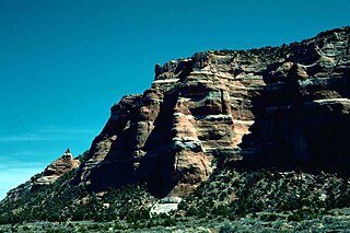
The Havasupai Indian Reservation is a Native American reservation for the Havasupai people, surrounded entirely by the Grand Canyon National Park, in Coconino County in Arizona, United States. It is considered one of America's most remote Indian reservations. The reservation is governed by a seven-member tribal council, led by a chairman who is elected from among the members of the council. The capital of the reservation is Supai, situated at the bottom of Cataract Canyon, one of the tributary canyons of the Grand Canyon. Havasupai is a combination of the words Havasu and pai, thus meaning "people of the blue-green waters".

The Pascua Yaqui Tribe of Arizona is a federally recognized tribe of Yaqui Native Americans in the state of Arizona.

The Colorado River Indian Tribes is a federally recognized tribe consisting of the four distinct ethnic groups associated with the Colorado River Indian Reservation: the Mohave, Chemehuevi, Hopi, and Navajo. The tribe has about 4,277 enrolled members. A total population of 9,485 currently resides within the tribal reservation according to the 2012-2016 American Community Survey data.
The Zuni Indian Reservation, also known as Pueblo of Zuni, is the homeland of the Zuni tribe of Native Americans. In Zuni language, the Zuni Pueblo people are referred to as A:shiwi, and the Zuni homeland is referred to as Halona Idiwan’a meaning Middle Place.

The Tohono Oʼodham Nation is the collective government body of the Tohono Oʼodham tribe in the United States. The Tohono Oʼodham Nation governs four separate pieces of land with a combined area of 2.8 million acres (11,330 km2), approximately the size of Connecticut and the second largest Indigenous land holding in the United States. These lands are located within the Sonoran Desert of south central Arizona and border the Mexico–United States border for 74 miles (119 km) along its southern border. The Nation is organized into 11 local districts and employs a tripartite system of government. Sells is the Nation's largest community and functions as its capital. The Nation has approximately 34,000 enrolled members, the majority of whom live off of the reservations.
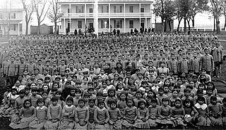
American Indian boarding schools, also known more recently as American Indian residential schools, were established in the United States from the mid-17th to the early 20th centuries with a primary objective of "civilizing" or assimilating Native American children and youth into Anglo-American culture. In the process, these schools denigrated Native American culture and made children give up their languages and religion. At the same time the schools provided a basic Western education. These boarding schools were first established by Christian missionaries of various denominations. The missionaries were often approved by the federal government to start both missions and schools on reservations, especially in the lightly populated areas of the West. In the late 19th and early 20th centuries especially, the government paid religious orders to provide basic education to Native American children on reservations, and later established its own schools on reservations. The Bureau of Indian Affairs (BIA) also founded additional off-reservation boarding schools based on the assimilation model. These sometimes drew children from a variety of tribes. In addition, religious orders established off-reservation schools.

The Bureau of Indian Education (BIE), headquartered in the Main Interior Building in Washington, D.C., and formerly known as the Office of Indian Education Programs (OIEP), is a division of the U.S. Department of the Interior under the Assistant Secretary for Indian Affairs. It is responsible for the line direction and management of all BIE education functions, including the formation of policies and procedures, the supervision of all program activities, and the approval of the expenditure of funds appropriated for BIE education functions.

The Phoenix Indian School, or Phoenix Indian High School in its later years, was a Bureau of Indian Affairs-operated school in Encanto Village, in the heart of Phoenix, Arizona. It served lower grades also from 1891 to 1935, and then served as a high school thereafter. It opened in 1891 and closed in 1990 on the orders of the federal government. During its existence, it was the only non-reservation BIA school in Arizona.
Arizona, a state in the southwestern region of the United States of America, is known for its high population of Native Americans. Arizona has the third highest number of Native Americans of any state in the Union. Out of the entire US population of 2.9 million Native Americans, roughly 286,680 live in Arizona, representing 10% of the country's total Native American population. Only California and Oklahoma have more Native Americans than Arizona by number. Arizona also has the highest proportion of land allocated to Native American reservations, at 28%. Arizona has five of the twelve largest Indian reservations in the United States, including the largest, the Navajo Nation, and the third-largest, the Tohono O'odham Nation. Also, Arizona has the largest number of Native American language speakers in the United States.
See also: Indigenous peoples of Arizona |