
The Guanella Pass Scenic Byway is a National Forest Scenic Byway and Colorado Scenic and Historic Byway located in Clear Creek and Park counties, Colorado, USA. The byway traverses Guanella Pass at elevation 11,670 feet (3,557 m) in Arapaho and Pike national forests. The pass lies above timberline surrounded by Grays Peak at elevation 14,278 feet (4,352 m), Torreys Peak 14,275 feet (4,351 m), Mount Blue Sky 14,271 feet (4,350 m), and Mount Bierstadt 14,065 feet (4,287 m). The byway passes through the Georgetown–Silver Plume Historic District, and provides access to the Georgetown Loop Historic Mining & Railroad Park and the Georgetown Loop Railroad. The byway is renowned for its spectacular autumn colors during aspen color change from September 10 through October 10 each year.
The Trail Ridge Road/Beaver Meadow National Scenic Byway is a 55-mile (89 km) All-American Road and Colorado Scenic and Historic Byway located in Rocky Mountain National Park in Larimer and Grand counties, Colorado, USA. The byway consists of the 48-mile (77 km) Trail Ridge Road and the connecting 6.9-mile (11 km) Beaver Meadow Road. With a high point at 12,183 feet (3,713 m) elevation, Trail Ridge Road is the highest continuous paved road in North America. The higher portion of Trail Ridge Road is closed from October to May. The Rocky Mountain National Park Administration Building is a National Historic Landmark.

The Arkansas Scenic Byways Program is a list of highways, mainly state highways, that have been designated by the Arkansas Department of Transportation (ArDOT) as scenic highways. The Arkansas General Assembly designates routes for scenic byway status upon successful nomination. For a highway to be declared scenic, a group interested in preserving the scenic, cultural, recreational, and historic qualities of the route must be created. Mayors of all communities along the route and county judges from each affected county must be included in the organization. Scenic highways are marked with a circular shield in addition to regular route markers.
This is a list of state scenic byways in Oregon. The byways are divided into two types: state scenic byways and touring routes.

The Trail of the Ancients is a collection of National Scenic Byways located in the U.S. Four Corners states of Utah, Colorado, New Mexico, and Arizona. These byways comprise:
The Peak to Peak Scenic Byway is a 55-mile (89 km) National Forest Scenic Byway and Colorado Scenic and Historic Byway located in Gilpin, Boulder, Larimer counties, Colorado, USA. The Peak to Peak Highway was originally built in 1918 and provides views of the Front Range mountains in the Colorado Rocky Mountains. It was Colorado's first scenic highway. The Central City/Black Hawk Historic District is a National Historic Landmark.
The South Platte River Trail Scenic and Historic Byway is a 19-mile (31 km) Colorado Scenic and Historic Byway located in Sedgwick County, Colorado, USA. The byway follows the historic trails used during westward expansion. The route, which includes County Road 28 (CR 28) and U.S. Highway 138 (US 138), connects Ovid and Julesburg and encircles the South Platte River. It was designated a Colorado Scenic and Historic Byway in 1991.
The Highway of Legends National Scenic Byway is an 82-mile (132 km) National Scenic Byway, National Forest Scenic Byway, and Colorado Scenic and Historic Byway located in Huerfano and Las Animas counties, Colorado, USA. The byway explores the Spanish Peaks region of San Isabel National Forest, a National Natural Landmark.
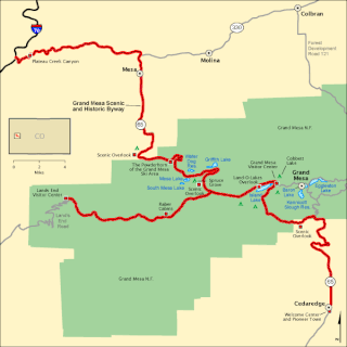
The Grand Mesa National Scenic Byway is a 63-mile (101 km) National Scenic Byway, National Forest Scenic Byway, and Colorado Scenic and Historic Byway located in Delta and Mesa counties, Colorado, USA. The byway traverses Grand Mesa, the most extensive flat-topped mountain on Earth, and reaches an elevation of 10,849 feet (3,307 m). The byway comprises Colorado State Highway 65 from Cedaredge to Interstate 70 Exit 49 and Forest Service Road 100 to the Land's End Observatory.
The Colorado River Headwaters National Scenic Byway is an 80-mile (129 km) National Scenic Byway and Colorado Scenic and Historic Byway located in Eagle and Grand counties, Colorado, US. The byway follows the upper Colorado River from Grand Lake down to State Bridge. The byway connects with the Trail Ridge Road/Beaver Meadow National Scenic Byway at Grand Lake.
The Flat Tops Trail Scenic Byway is a National Forest Scenic Byway and Colorado Scenic and Historic Byway located in Routt, Garfield, and Rio Blanco counties, Colorado, US.
The Frontier Pathways is a 103-mile (166 km) National Scenic Byway and Colorado Scenic and Historic Byway located in Custer and Pueblo counties, Colorado, US.
The Los Caminos Antiguos Scenic and Historic Byway is a 129-mile (208 km) Back Country Byway and Colorado Scenic and Historic Byway located in Alamosa, Conejos, and Costilla counties, Colorado, USA. The byway explores the historic San Luis Valley of south-central Colorado including Great Sand Dunes National Park and Preserve; the Old Spanish National Historic Trail; historic Fort Garland, San Luis (San Luis de la Culebra), the oldest town in Colorado; and the Cumbres and Toltec Scenic Railroad.
The Pawnee Pioneer Trails Scenic and Historic Byway is a 128-mile (206 km) Colorado Scenic and Historic Byway located in Logan, Morgan, and Weld counties, Colorado, USA. The byway explores the Pawnee Buttes region and Pawnee National Grassland of northeastern Colorado.
The Tracks Across Borders Scenic and Historic Byway is an 89-mile (143 km) Colorado Scenic and Historic Byway located in La Plata and Archuleta counties, Colorado, USA. From Durango, Colorado, the southern terminal of the Durango and Silverton Narrow Gauge Railroad, a National Historic Landmark, the byway follows the roadbed of the historic narrow-gauge Denver and Rio Grande Western Railroad through the Southern Ute Indian Reservation to the New Mexico state line. At the state line, the byway connects with the 9.9-mile (16 km) Narrow-Gauge Scenic Byway which continues on through the Jicarilla Apache Indian Reservation to Dulce, New Mexico. New Mexico plans to continue the byway on to Chama, New Mexico, the southern terminal of the Cumbres and Toltec Scenic Railroad, another National Historic Landmark, reconnecting the historic railway between Antonito, Colorado and Silverton, Colorado.
The Unaweep Tabeguache Scenic Byway is a 133-mile (214 km) Colorado Scenic and Historic Byway located in Mesa, Montrose, and San Miguel counties, Colorado, USA. The byway explores the Colorado Plateau canyon country of far western Colorado.
The West Elk Loop Scenic and Historic Byway is a 205-mile (330 km) National Forest Scenic Byway and Colorado Scenic and Historic Byway located in Delta, Garfield, Gunnison, Montrose, and Pitkin counties Colorado, USA. The byway reaches its zenith at Kebler Pass, elevation 10,007 feet (3,050 m), between Crested Butte and Paonia.