The Ozarks, also known as the Ozark Mountains, Ozark Highlands or Ozark Plateau, is a physiographic region in the U.S. states of Missouri, Arkansas, Oklahoma and the extreme southeastern corner of Kansas. The Ozarks cover a significant portion of northern Arkansas and most of the southern half of Missouri, extending from Interstate 40 in central Arkansas to Interstate 70 in central Missouri.

The White River is a 722-mile (1,162 km) river that flows through the U.S. states of Arkansas and Missouri. Originating in the Boston Mountains of northwest Arkansas, it arcs northwards through southern Missouri before turning back into Arkansas, flowing southeast to its mouth at the Mississippi River.

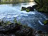
A spring is a natural exit point at which groundwater emerges out of the aquifer and flows onto the top of the Earth's crust (pedosphere) to become surface water. It is a component of the hydrosphere, as well as a part of the water cycle. Springs have long been important for humans as a source of fresh water, especially in arid regions which have relatively little annual rainfall.

The Spring River is a 57-mile (92 km) long river which flows through the U.S. states of Missouri and Arkansas. It consists of two branches, the South Fork of the Spring River and the Spring River proper. The South Fork of the Spring River starts in Howell County, Missouri and flows south through Fulton and Sharp counties in Arkansas. The South Fork of the Spring River joins the Spring River proper near the town of Hardy, Arkansas. The South Fork is a quiet stream with gravelly bars that are ideal for camping.
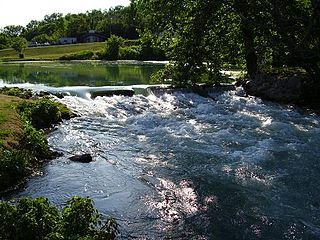
Mammoth Spring is a large, first magnitude karst spring that arises in the Ozark Plateau within the state of Arkansas. It is the largest spring in Arkansas and the third-largest spring within the Ozark Plateau region behind Big Spring and Greer Spring. Mammoth Spring is the seventh-largest natural spring in the world.

The Current River forms in the southeastern portion of the Ozarks of Missouri and becomes a 7th order stream as it flows southeasterly out of the Ozarks into northeastern Arkansas where it becomes a tributary of the Black River, which is a tributary of the White River, a tributary of the Mississippi River. The Current River is approximately 184 miles (296 km) long and drains about 2,641 square miles (6,840 km2) of land mostly in Missouri and a small portion of land in northeastern Arkansas. The headwaters of the Current River are nearly 900 feet (270 m) above sea level, while the mouth of the river lies around 280 feet (85 m) above sea level. The basin drains a rural area that is dominated by karst topography, underlain by dolomite and sandstone bedrock with a small area of igneous rock southeast of Eminence, Missouri. The annual daily mean discharge of the river near Doniphan, Missouri is 2,815 cubic feet (79.7 m3) per second. In 1964, over 134 mi (160 km) of the upper course of the river and its tributaries were federally protected as the Ozark National Scenic Riverways, the first national park in America to protect a river system.

The Gasconade River is about 280 miles (450 km) long and is located in central and south-central Missouri.

The Spring River is a 129-mile-long (208 km) waterway located in southwestern Missouri, southeastern Kansas, and northeastern Oklahoma.
The James River is a 130-mile-long (210 km) river in southern Missouri. It flows from northeast Webster County until it is impounded into Table Rock Lake. It is part of the White River watershed. The river forms Lake Springfield and supplies drinking water for the city of Springfield.

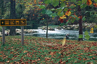
The Ozark National Scenic Riverways is a recreational unit of the National Park Service in the Ozarks of southern Missouri in the U.S.

The Roaring River is a 14.9-mile-long (24.0 km) river in Barry County, Missouri, in the Ozarks. It is a tributary of the White River, into which it flows in Eagle Rock, Missouri. This section of the White River is a reservoir called Table Rock Lake.

The North Fork River or the North Fork of White River is a 109-mile-long (175 km) tributary of the White River, into which it flows near Norfork, Arkansas.
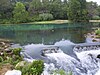
Bennett Spring State Park is a public recreation area located in Bennett Springs, Missouri, twelve miles (19 km) west of Lebanon on Highway 64 in Dallas and Laclede counties. It is centered on the spring that flows into the Niangua River and gives the park its name. The spring averages 100 million gallons of daily flow. The park offers fly fishing, camping, canoeing, hiking, and other activities.

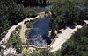
Roubidoux Spring is a second magnitude freshwater spring located within the city limits of Waynesville in the Missouri Ozarks. The spring discharges from the base of a rock ledge that has been capped by a large concrete wall, built to hold the road that passes over the spring. Spring water flows a very short distance before adding its waters to the Roubidoux Creek. A city park with trails and a board walk has been developed around the spring. This spring is noted as having an average discharge of 58.3 ft³/s. However, due to very limited discharge data, an accurate description of the flow of this particular spring may be difficult to find. This could be a first magnitude spring – over 100 ft³/s. According to some lists, this ranks as the 15th largest spring in the state. The area near this spring has very intense karst topography, many caves, springs and large sink holes are present within a few miles of this spring.

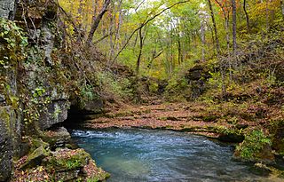
Jacks Fork is one of two rivers in Missouri that are part of the Ozark National Scenic Riverways system.

The geography of Arkansas varies widely. The state is covered by mountains, river valleys, forests, lakes, and bayous in addition to the cities of Arkansas. Hot Springs National Park features bubbling springs of hot water, formerly sought across the country for their healing properties. Crowley's Ridge is a geological anomaly rising above the surrounding lowlands of the Mississippi embayment.

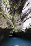
Big Spring is one of the largest springs in the United States and the world. An enormous first magnitude spring, it rises at the base of a bluff on the west side of the Current River valley in the Missouri Ozarks.
Greer Spring is a first magnitude spring located in the southeast portion of the Ozark Plateau, in Oregon County in south-central Missouri within the boundaries of the Mark Twain National Forest. The spring is the second largest spring in the Ozarks, with an average discharge of 360 cubic feet (10 m3) of water per second. Greer Spring was designated a National Natural Landmark in 1980.

The United States Geological Survey (USGS), founded as the Geological Survey, is an agency of the United States government whose work spans the disciplines of biology, geography, geology, and hydrology. The agency was founded on March 3, 1879, to study the landscape of the United States, its natural resources, and the natural hazards that threaten it. The agency also makes maps of extraterrestrial planets and moons based on data from U.S. space probes.
Bryant Creek is a stream in the Ozarks of Missouri. Bryant Creek has headwaters just west of Lead Hill and southeast Cedar Gap in southwestern Wright County and flows in a southeasterly direction through Douglas County east of Ava and joins the North Fork River in Ozark County just north of Tecumseh and within the waters of Norfork Lake. Tributaries include Bill Macks Creek, Hunter Creek, Rippee Creek, Fox Creek, Brush Creek, Spring Creek and Pine Creek.