
800–1000 m
700–799 m
600–699 m
500–599 m
400–499 m
300–399 m
250–299 m
200–249 m
160–199 m
125–159 m
0–124 m
This is a list of the ceremonial counties of England by their highest point. [1] [2] [3]
This is a list of the ceremonial counties of England by their highest point. [1] [2] [3]

The United Kingdom is a sovereign state located off the north-western coast of continental Europe. With a total area of approximately 244,376 square kilometres (94,354 sq mi), the UK occupies the major part of the British Isles archipelago and includes the island of Great Britain, the north-eastern one-sixth of the island of Ireland and many smaller surrounding islands. It is the world's 7th largest island country. The mainland areas lie between latitudes 49°N and 59°N, and longitudes 8°W to 2°E. The Royal Observatory, Greenwich, in south-east London, is the defining point of the Prime Meridian.

Cumbria is a ceremonial county in North West England. It borders the Scottish council areas of Dumfries and Galloway and Scottish Borders to the north, Northumberland and County Durham to the east, North Yorkshire to the south-east, Lancashire to the south, and the Irish Sea to the west. Its largest settlement is the city of Carlisle.

The Midlands is the central part of England, bordered by Wales, Northern England, Southern England and the North Sea. The Midlands correspond broadly to the early-medieval kingdom of Mercia, and later became important in the Industrial Revolution of the 18th and 19th centuries. They are now split into two official regions, the West Midlands and East Midlands. The Midlands' biggest city, Birmingham, is the second-largest in the United Kingdom. Other important cities include Coventry, Derby, Leicester, Lincoln, Nottingham, Stoke-on-Trent, Wolverhampton, and Worcester.

Cumberland is an historic county in Northern England, it mainly corresponds to the district of Cumberland and the part of Westmorland and Furness including Penrith.

The administrative geography of the United Kingdom is complex, multi-layered and non-uniform. The United Kingdom, a sovereign state to the northwest of continental Europe, consists of England, Northern Ireland, Scotland and Wales. For local government in the United Kingdom, England, Northern Ireland, Scotland and Wales each have their own system of administrative and geographic demarcation. Consequently, there is "no common stratum of administrative unit encompassing the United Kingdom".
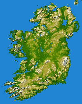
In these lists of mountains in Ireland, those within Northern Ireland, or on the Republic of Ireland – United Kingdom border, are marked with an asterisk, while the rest are within the Republic of Ireland. Where mountains are ranked by height, the definition of the topographical prominence used to classify the mountain, is noted. In British definitions, a height of 600 metres (1,969 ft) is required for a mountain, whereas in Ireland, a lower threshold of 500 metres (1,640 ft) is sometimes advocated.

The Kent Downs is an Area of Outstanding Natural Beauty (AONB) in Kent, England. They are the eastern half of the North Downs and stretch from the London/Surrey borders to the White Cliffs of Dover, including a small section of the London Borough of Bromley. The AONB also includes the Greensand Ridge, a prominent sandstone escarpment which lies south of the chalk escarpment of the North Downs.
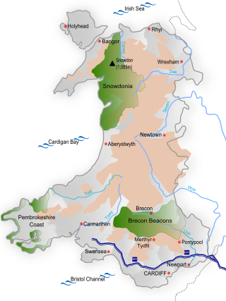
Wales is a country that is part of the United Kingdom and whose physical geography is characterised by a varied coastline and a largely upland interior. It is bordered by England to its east, the Irish Sea to its north and west, and the Bristol Channel to its south. It has a total area of 2,064,100 hectares and is about 170 mi (274 km) from north to south and at least 60 mi (97 km) wide. It comprises 8.35 percent of the land of the United Kingdom. It has a number of offshore islands, by far the largest of which is Anglesey. The mainland coastline, including Anglesey, is about 1,680 mi (2,704 km) in length. As of 2014, Wales had a population of about 3,092,000; Cardiff is the capital and largest city and is situated in the urbanised area of South East Wales.

England comprises most of the central and southern two-thirds of the island of Great Britain, in addition to a number of small islands of which the largest is the Isle of Wight. England is bordered to the north by Scotland and to the west by Wales. It is closer to continental Europe than any other part of mainland Britain, divided from France only by a 33 km (21 mi) sea gap, the English Channel. The 50 km (31 mi) Channel Tunnel, near Folkestone, directly links England to mainland Europe. The English/French border is halfway along the tunnel.

The mountains and hills of the British Isles are categorised into various lists based on different combinations of elevation, prominence, and other criteria such as isolation. These lists are used for peak bagging, whereby hillwalkers attempt to reach all the summits on a given list, the oldest being the 282 Munros in Scotland, created in 1891.
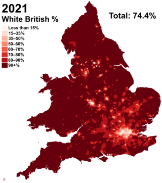
White British is an ethnicity classification used for the native white population identifying as English, Scottish, Welsh, Cornish, Northern Irish, or British in the United Kingdom Census. In the 2011 census, the White British population was 49,997,686, 81.5% of Great Britain's total population. For the United Kingdom entirely, due to different reporting measures within Northern Ireland which includes all those who identified as British with those who identified as Irish, an amalgamated total of 52,320,080 including those who identified as White Irish in Great Britain is given making up 82.8% of the population.

Silverhill is an artificial hill near Teversal in Nottinghamshire, and is one of the highest points in the county at 204.3 metres (670 ft). Originally it was a mine spoil heap on the site of the former Silverhill colliery which closed in the 1990s. It was subsequently landscaped in 2005 by Nottinghamshire County Council, with tree planting, numerous footpaths, and a viewpoint. It is now known as Silverhill Woods, and is one of a number of recreation sites in the area. These are linked together by multi-user trails, many of which incorporate the track beds of disused railway lines which once served the various local collieries.

Currock Hill is a hill in Tyne and Wear, England, which at 259 m (850 ft) is the highest point in the county, and in the metropolitan borough of Gateshead.
| British Isles |  | |
|---|---|---|
| Scotland | ||
| Outside Scotland | ||
| England | ||
| Ireland | ||
| County tops | ||