List of coal mines and landmarks in the Nanaimo area

Last updated

This is a list of landmarks and historic locations, mostly related to coal mining, in the vicinity of the City of Nanaimo in the Canadian province of British Columbia.

Contents

Origins of Nanaimo - Coal

Most of these landmarks relate to the city's history as a coal-mining town. Coal was discovered in the area in 1849. Joseph William McKay took possession of the deposits for the Hudson's Bay Company (HBC) in 1852 at the direction of Governor James Douglas. [1] The area was first known as Wintuhuysen Inlet and then Colvile Town (named for HBC Governor Andrew Colvile) but became known as Nanaimo in 1860. The first church opened in 1861. In 1853 the population was 125. By 1869 it was about 650 and by 1874 it was close to 1,000.

By 1859, 25,000 tons of coal had been shipped from Nanaimo, mostly to San Francisco. In 1862 the HBC sold its coal interests to an English Company known as the Vancouver Coal Mining and Land Company (VCML). Output was 100 tons a day by 1863 and double that by 1866. By 1874, annual production was 80,000 tons and it was 10 times that by 1884. The mines in Wellington were owned by Robert Dunsmuir. Initially his company was Dunsmuir, Diggle and Co., but after he bought out his partners he carried on as R. Dunsmuir and Sons. The family company was sold by son James Dunsmuir in 1910 to Canadian Collieries (Dunsmuir) Ltd. (CCD). The VCML mines were mainly under Nanaimo and the harbour. The East Wellington colliery was owned by R.D. Chandler of San Francisco. Peak production of the Nanaimo coal fields was 1,400,000 tons in 1922. Production declined steadily after that. The last mine in Nanaimo closed in 1968. In the early 1980s the Wolf mountain coal mine opened up and produced coal from the Wellington seam until 1987. [2]

Locations shown are generally for the main shaft entrance although some mines, Extension No. 8 for example, had numerous slope shaft entrances as well.

Landmarks of Nanaimo

Map all coordinates using: OpenStreetMap  
Download coordinates as: KML
SiteLocationRemarks
Mount Benson 49°08′59″N124°03′04″W / 49.14972°N 124.0511°W / 49.14972; -124.0511 (Mount Benson)
Nanaimo's First School 49°09′56″N123°56′13″W / 49.165546°N 123.937063°W / 49.165546; -123.937063 (First School in Nanaimo) Built on this site by the HBC [3]
HBC Fort (Bastion) 49°10′01″N123°56′08″W / 49.167062°N 123.935636°W / 49.167062; -123.935636 (HBC Fort (Bastion)) Built in 1853 [3]
Dunsmuir home 49°10′03″N123°56′11″W / 49.167451°N 123.936296°W / 49.167451; -123.936296 (First home of Robert Dunsmuir) Small square hewn log cabin, first Nanaimo home of Robert Dunsmuir faced Front Street from this location. [3]
Ardoon 49°09′48″N123°56′13″W / 49.16347°N 123.936966°W / 49.16347; -123.936966 (Ardoon (Dunsmuir Residence)) Location of Robert Dunsmuir log residence built in 1858 where the family lived until they moved to Victoria in 1882. [3]
Royal Hotel 49°09′56″N123°56′12″W / 49.16562°N 123.936703°W / 49.16562; -123.936703 (Royal Hotel) Prime Minister Sir John A. Macdonald and Robert Dunsmuir had lunch here the day they drove the last spike on the E&N Railway. [3] The hotel and the fire hall next door were destroyed by fire September 28, 1894. It opened January 21, 1879. [4]
Nanaimo Court House 49°10′08″N123°56′17″W / 49.168926°N 123.937996°W / 49.168926; -123.937996 (Nanaimo Court House) Built in 1895 and opened in 1896, this building was designed by Francis Rattenbury [5]
E&N Railway Station 49°09′50″N123°56′32″W / 49.163999°N 123.942223°W / 49.163999; -123.942223 (E&N Station) Location of Esquimalt and Nanaimo Railway station built in 1886 by Robert Dunsmuir and replaced by the present building, which has been damaged by fire, in 1920.
Pithead of HBC Number One Shaft [3] 49°09′59″N123°56′10″W / 49.166262°N 123.936183°W / 49.166262; -123.936183 (Number One Shaft)
Dunsmuir Level-Free Mine 49°09′45″N123°56′02″W / 49.162617°N 123.933887°W / 49.162617; -123.933887 (Dunsmuir Level-Free Mine) Location where Robert Dunsmuir first operated as a free miner under contract to the HBC. [3]
Douglas Mine 49°09′44″N123°56′05″W / 49.162291°N 123.934659°W / 49.162291; -123.934659 (Douglas Mine) The first big Nanaimo coal mine. Also called Douglas Pit [3] and Old Douglas Mine. There were 3 further shafts within 150 metres to the south west, a fifth shaft 300 metres south west (between Selby Street and Prideaux on the west side of Hecate) and another 400 metres south ( 49°09′32″N123°56′05″W / 49.158885°N 123.934831°W / 49.158885; -123.934831 (Douglas Mine) )
Douglas Old Slope 49°08′24″N123°55′37″W / 49.14011°N 123.92707°W / 49.14011; -123.92707 (Douglas Old Slope) Another shaft: 49°08′29″N123°56′00″W / 49.14152°N 123.93329°W / 49.14152; -123.93329 (Douglas Slope) [6]
Other Downtown Nanaimo 49°09′59″N123°56′12″W / 49.166497°N 123.9368°W / 49.166497; -123.9368 (Other Downtown Nanaimo) 5 shaft entrances existed starting at this location and running south along east side of Commercial street. An additional slope entrance existed at 49°09′59″N123°56′08″W / 49.166497°N 123.935577°W / 49.166497; -123.935577 (Other Downtown Nanaimo) A shaft entrance existed at 49°10′08″N123°56′13″W / 49.169015°N 123.93681°W / 49.169015; -123.93681 (Unknown shaft) and slope entrances were located at 49°10′12″N123°56′17″W / 49.169927°N 123.937969°W / 49.169927; -123.937969 (Unknown slope) , 49°10′11″N123°56′21″W / 49.169808°N 123.939042°W / 49.169808; -123.939042 (Unknown slope) and 49°10′03″N123°56′20″W / 49.167367°N 123.938967°W / 49.167367; -123.938967 (Unknown slope) .
Newcastle Island Mine 49°11′29″N123°55′36″W / 49.191472°N 123.926736°W / 49.191472; -123.926736 (Newcastle Island Mine) [7]
Protection Island Mine 49°10′20″N123°55′02″W / 49.172361°N 123.917284°W / 49.172361; -123.917284 (Protection Island Mine) On September 19, 1918 a cable lowering the cage broke and the 16 miners in it died. [7]
E&N Roundhouse (Wellington) 49°12′17″N124°01′02″W / 49.204785°N 124.017094°W / 49.204785; -124.017094 (E&N Roundhouse) Roundhouse and shops were here until 1914 when the track was extended to Courtenay [3]
Ardoon (Wellington) 49°12′19″N124°01′35″W / 49.205325°N 124.026369°W / 49.205325; -124.026369 (Ardoon (Wellington)) James Dunsmuir and his wife Laura lived in a home here from 1876 to 1888 [3]
Old Slope (Wellington) 49°12′16″N124°02′06″W / 49.204448°N 124.034872°W / 49.204448; -124.034872 (Old Slope) Location of the original Wellington mine. Operated from 1872 to 1888. Location of significant labour strike. [3]
Number Three Shaft 49°11′53″N124°01′56″W / 49.198111°N 124.032211°W / 49.198111; -124.032211 (Number Three Shaft) Mine operated from 1880 to 1899 [3]
Number Four Shaft 49°11′43″N124°01′17″W / 49.195195°N 124.02144°W / 49.195195; -124.02144 (Number Four Shaft) Operated from 1881 to 1897. Robert Dunsmuir first found conglomerate rock here which lead to his own coal seam. [3]
Number Six Shaft 49°11′10″N124°00′07″W / 49.186023°N 124.001913°W / 49.186023; -124.001913 (Number Six Shaft) The second mine opened on the Bluffs, this was the last Wellington mine opened. It operated from 1884 to 1899. [3]
Number Five Shaft 49°12′05″N124°00′48″W / 49.20128°N 124.013329°W / 49.20128; -124.013329 (Number Five Shaft) This was the largest Wellington mine. It operated from 1884 to 1900. A large explosion in 1888 killed 68 men. [3]
North Wellington Mine 49°12′20″N124°02′06″W / 49.205542°N 124.03513°W / 49.205542; -124.03513 (North Wellington Mine) Location is one of more than a dozen shaft and slope entrances lying to the south.

[7]

https://virl.bibliocommons.com/item/show/1053938107?active_tab=bib_info

Wellington Mine 49°12′00″N124°00′48″W / 49.199948°N 124.013414°W / 49.199948; -124.013414 (Wellington Mine) One of several shaft entrances in radius of 400 metres. [7]
East Wellington Mine 49°06′08″N123°56′24″W / 49.102168°N 123.93989°W / 49.102168; -123.93989 (East Wellington Mine) [7]
Chandler Mine 49°06′08″N123°56′24″W / 49.102168°N 123.93989°W / 49.102168; -123.93989 (Chandler Mine) [7]
Northfield Mine No 1 Shaft 49°12′20″N123°59′10″W / 49.205626°N 123.986024°W / 49.205626; -123.986024 (Northfield Mine No 1 Shaft) Workings lay south and west. Railway followed Neyland Road from shaft to Departure Bay Road. [7]
Northfield Shaft 49°11′45″N123°59′55″W / 49.195741°N 123.998694°W / 49.195741; -123.998694 (Northfield Shaft) Two other shafts within 200 metres. [7]
Wellington's First Public School 49°12′24″N124°01′18″W / 49.206688°N 124.021619°W / 49.206688; -124.021619 (First Public School in Wellington) Built by Dunsmuir & Diggle Ltd in 1874 for the new Wellington School District, replacing the company operated school. Still a public school site.
Wellington Bunkers and South Wharf 49°11′49″N123°57′48″W / 49.196961°N 123.963418°W / 49.196961; -123.963418 (Wellington Bunkers and South Wharf) Served by local railway. [7]
East Wellington Wharf 49°11′37″N123°57′18″W / 49.193708°N 123.955135°W / 49.193708; -123.955135 (East Wellington Wharf) [7]
Northfield Wharf 49°11′34″N123°57′02″W / 49.192699°N 123.9505°W / 49.192699; -123.9505 (Northfield Wharf) [7]
Jingle Pot Wharf 49°10′45″N123°56′37″W / 49.179263°N 123.943484°W / 49.179263; -123.943484 (Jingle Pot Wharf) [7]
East Wellington Mine 49°10′24″N123°59′15″W / 49.173231°N 123.987365°W / 49.173231; -123.987365 (East Wellington Mine) One of 6 entrances lying within 1 km south east. [7]
Jingle Pot Mine 49°10′01″N123°58′32″W / 49.166974°N 123.975692°W / 49.166974; -123.975692 (Jingle Pot Mine) One of 4 shaft entrances. The others lie along the Nanaimo Parkway to the west and south. [7]
Wakesiah Colliery 49°09′39″N123°58′01″W / 49.160912°N 123.966873°W / 49.160912; -123.966873 (Wakesiah Colliery) The Canadian Western Fuel Company sunk 2 shafts in 1918. The mine was operated until 1930 producing 767,025 tons of high quality coal. [7]
Wellington Colliery North Wharf 49°12′24″N123°58′02″W / 49.206678°N 123.967237°W / 49.206678; -123.967237 (Wellington Colliery North Wharf) In use from 1871 to 1900 when the mines closed. Destroyed by fire shortly after mines closed. [3] The colliery was served by a railway built in 1883 that ran along the south side of Long Lake to the Wellington Mine and the North Wellington Mine. It ran to various mining locations in the city of Nanaimo.
Nanaimo No. 1 Esplanade 49°09′29″N123°55′44″W / 49.157923°N 123.929004°W / 49.157923; -123.929004 (Nanaimo No. 1 Esplanade) Coal seam owned by HBC. Acquired by VCMLC in 1862 and mined by them from 1881 until 1938 producing 17 million tons of coal. [7] Dunsmuir and Prime Minister Macdonald toasted the completion of the E& N Railway with whiskey here at a depth of 700 feet. This is the location of the worst mining disaster in BC history, the 1887 Nanaimo mine explosion in which 150 miners died. [8] Workings extend beneath the sea to 1.6 km to the east running north .8 km and south 2 km. There were two further shafts 100 and 200 metres south of marked location. [7]
Harewood Mine 49°07′55″N123°57′45″W / 49.1319°N 123.962431°W / 49.1319; -123.962431 (Harewood Mine) Managed by Dunsmuir for Dr Alfred Benson and Horace Douglas Lascelles (7th son of the Earl of Harewood) when it opened in 1875. There were workings from 1864 as well for which there are no records. It closed in 1894 and operated again from 1902 to 1904. A new tunnel was opened in 1917 and during the next 6 years 769,500 tons were produced. [7]
Furnace Portal (Biggs) Mine 49°07′47″N123°58′23″W / 49.129724°N 123.972988°W / 49.129724; -123.972988 (Furnace Portal (Biggs) Mine) In the vicinity of the Harewood Mine, there were workings here from 1945 to 1951 The mine last operated under the name Biggs Mine. [7]
Extension Mines 49°05′53″N123°58′09″W / 49.097925°N 123.969212°W / 49.097925; -123.969212 (Extension Mines) 3 large mines in this area were opened by James Dunsmuir in 1895 and sold to Canadian Collieries (Dunsmuir) Ltd which operated them until 1932. [3] Dunsmuir purchased the property after its owner, Louis Stark, a black settler, fell to his death. He had refused to sell to several interested buyers. His death was unexplained. There are several mines in this area which operated for 32 years. During that time more than 105 men died in mining accidents. More than 900 men were employed in the Extension Mines. In 1901 a fire here killed 17 men. The mine was flooded to control the blaze. An explosion in 1932 killed 32 men. [7]
Extension Colliery 49°06′08″N123°57′21″W / 49.102217°N 123.955827°W / 49.102217; -123.955827 (Extension Colliery) The Colliery had an electric train that ran under the mountain for 2 miles connecting Mine No. 1, 2 and 3 which lay to the South West of the Colliery. During the miner's strike of 1913 the electric train and its rails were destroyed by rioters. [7]
Extension Mine No 8 49°03′38″N123°58′00″W / 49.060567°N 123.966637°W / 49.060567; -123.966637 (Extension Mine No 8) Extension No. 8 mine was opened by Canadian Collieries (Dunsmuir) Ltd in 1926. In 1928, the year it was closed, it produced 35,206 tonnes. It reopened as Timberland Colliery from 1945 to 1955 and as Lewis Mine from 1951 to 1966. [7]
Extension Mine No 4 49°05′01″N123°55′57″W / 49.083606°N 123.932573°W / 49.083606; -123.932573 (Extension Mine No 8) Hoisting Shaft. There are three other shaft entrances in the area. [7]
Extension Prospect Mine 49°06′28″N123°57′21″W / 49.107759°N 123.955822°W / 49.107759; -123.955822 (Extension Mine No 8) Slope entrance. There was a second slope entrance 150 meters south east. [7]
White Rapids Mine 49°04′05″N123°58′04″W / 49.068046°N 123.967731°W / 49.068046; -123.967731 (White Rapids Mine) Also Berkley Mine, Biggs Mine. [7]
Blue Flame Mine 49°06′08″N123°56′24″W / 49.102168°N 123.93989°W / 49.102168; -123.93989 (Blue Flame Mine) Operated by Timberlands Colliery between 1952 and 1957, this mine produced 1592 tonnes of coal. [7]
Coal Wharfs [7] 49°10′06″N123°56′00″W / 49.16844°N 123.933442°W / 49.16844; -123.933442 (Coal Wharfs)
Reserve Mine 49°07′36″N123°52′52″W / 49.126578°N 123.881149°W / 49.126578; -123.881149 (Reserve Mine) Construction began in 1910 and it found the Douglas Seam in May 1913 but closed when the strike that year started. It ran from 1914 to 1930 when the mine was closed and allowed to flood. It reopened in 1934 and produced large quantities of coal until 1939. Unlike other mines, the chambers were large enough for miners to stand upright while working. 22 men were killed in an explosion May 27, 1915. [9] Location given is No. 1 Shaft. No. 2 Shaft was 200 metres to the east. Workings covered a large area extending were to the south with some workings to the north east as well. [7]
South Wellington Canadian Colliery No. 5 49°05′43″N123°53′46″W / 49.095252°N 123.896143°W / 49.095252; -123.896143 (South Wellington Canadian Colliery No. 5) Owned by Canadian Collieries (Dunsmuir) Ltd. Began in 1917, the mines here operated until 1935 but had many problems with spontaneous combustion and explosions that lead to many deaths. [7]
South Wellington No. 10 49°05′19″N123°53′35″W / 49.088722°N 123.893037°W / 49.088722; -123.893037 (South Wellington No. 10) Canadian Collieries (Dunsmuir) Ltd ran this mine, the largest producer in the South Wellington District for 13 years. It shut down in January 1952 after producing 2.5 million tons of coal. Workings cover a large area running south of the opening to the Nanaimo River. These mines were also called the Black Track Mines. Slope entrance. [7]
Overlap Seam 49°04′55″N123°53′30″W / 49.081878°N 123.891771°W / 49.081878; -123.891771 (Overlap Seam) Part of South Wellington No. 10. Shaft Entrance. [7]
Morden Mine 49°05′41″N123°52′24″W / 49.094765°N 123.873221°W / 49.094765; -123.873221 (Morden Mine) The Morden mine began in March 1912. It operated until 1921 and again briefly in 1930. See Morden Colliery Historic Provincial Park [10] It was operated by Pacific Coast Coal Mines Ltd. It produced 76,000 tonnes and a further 3,000 tonnes when it was open in 1930. [7]
Alexandria Mine 49°06′03″N123°54′02″W / 49.100847°N 123.900644°W / 49.100847; -123.900644 (Alexandria Mine) In South Wellington along the E&N Railway this mine produced from 1884 to 1902. A school built in 1898 was named after the mine but was renamed South Wellington School in 1911 and remains as the South Wellington Community Hall. The mine was operated by Dunsmuir & Sons. [7]
Fiddick Colliery 49°06′23″N123°54′17″W / 49.106256°N 123.904667°W / 49.106256; -123.904667 (Fiddick Colliery) Operated by Fiddick and Richardson from 1907 to 1912 and then was sold to Pacific Coast Mines Ltd who ran it until 1917. The Fiddick Mine ran again from 1927 to 1939. [7]
Richardson Mine 49°06′20″N123°54′14″W / 49.10542°N 123.903894°W / 49.10542; -123.903894 (Richardson Mine) The Richardson Mine (also called the Ida Clara Colliery) operated again from 1931 to 1940. [7]
Pacific Coast Collieries Mines [7] 49°06′20″N123°54′15″W / 49.105643°N 123.904098°W / 49.105643; -123.904098 (Pacific Coast Collieries Mines)
Beban Mine 49°06′02″N123°59′49″W / 49.100566°N 123.997021°W / 49.100566; -123.997021 (Beban Mine) This small mine was opened by Frank Beban of Beban Logging in 1935. It closed in 1941 having produced 75,962 tonnes of coal. In 1937, 3 men were killed in a flood in this mine. [7]
Bright Mine 49°03′44″N123°53′17″W / 49.062141°N 123.888177°W / 49.062141; -123.888177 (Bright Mine) The mine operated from 1950 to 1953 producing a total of 179,241 tonnes of the highest quality coal by extracting the pillars of the Granby mine. [7]
Granby Mine 49°03′53″N123°53′02″W / 49.064616°N 123.883874°W / 49.064616; -123.883874 (Granby Mine) The seven different mines were worked from 1917 to 1953 and produced over 2.5 million tonnes. [7]
Brechin Mine 49°11′48″N123°56′39″W / 49.196625°N 123.944063°W / 49.196625; -123.944063 (Brechin Mine) Also known as No 4 Northfield Mine located under most of Newcastle Island and Protection Island and seaward. [7] See Newcastle Island Marine Provincial Park.

See also

Related Research Articles

<span class="mw-page-title-main">Nanaimo</span> City in British Columbia, Canada

Nanaimo is a city on the east coast of Vancouver Island, in British Columbia, Canada. As of the 2021 census, it had a population of 99,863, and it is known as "The Harbour City." The city was previously known as the "Hub City," which was attributed to its original layout design, whose streets radiated from the shoreline like the spokes of a wagon wheel, and to its central location on Vancouver Island. Nanaimo is the headquarters of the Regional District of Nanaimo.

<span class="mw-page-title-main">Saysutshun (Newcastle Island Marine) Park</span> Canadian provincial park

Saysutshun Provincial Park, formally known as Newcastle Island Marine Provincial Park, is a provincial park located on a small island off the coast of Nanaimo, British Columbia, Canada.

<span class="mw-page-title-main">Ladysmith, British Columbia</span> Town in British Columbia, Canada

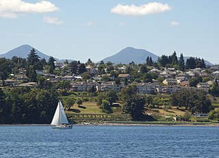
Ladysmith, originally Oyster Harbour, is a town located on the 49th parallel north on the east coast of Vancouver Island, British Columbia, Canada. The local economy is based on forestry, tourism, and agriculture. A hillside location adjacent to a sheltered harbour forms the natural geography of the community.

<span class="mw-page-title-main">James Dunsmuir</span> British Columbian industrialist and politician (1851–1920)

James Dunsmuir was a Canadian industrialist and politician in British Columbia. He served as the 14th premier of British Columbia from 1900 to 1902 and the eighth lieutenant governor of British Columbia from 1906 to 1909.

<span class="mw-page-title-main">1887 Nanaimo mine explosion</span> 1887 mine explosion in British Columbia

The Nanaimo mine explosion occurred on May 3, 1887, in Nanaimo, British Columbia killing 150 miners. Only seven miners survived and the mine burned for one full day.

<span class="mw-page-title-main">Robert Dunsmuir</span> Canadian businessman and politician

Robert Dunsmuir was a Scottish-Canadian coal mine developer, owner and operator, railway developer, industrialist and politician in British Columbia.

Cassidy is an unincorporated community straddling Haslam Creek. near the east coast of southern Vancouver Island, British Columbia, Canada. The location on BC Highway 19 is about 98 kilometres (61 mi) by road north-west of Victoria, and 14 kilometres (9 mi) south of Nanaimo.

Cumberland is an incorporated village municipality east of Perseverance Creek, near the east coast of central Vancouver Island, British Columbia. The Comox Valley community is west of BC Highway 19 and is by road about 105 kilometres (65 mi) northwest of Nanaimo and 10 kilometres (6 mi) southwest of Courtenay.

<span class="mw-page-title-main">Departure Bay</span> Bay in British Columbia, Canada

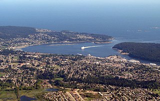
Departure Bay is a bay in central Nanaimo, British Columbia, on the east coast of Vancouver Island. The surrounding neighbourhood is also referred to as "Departure Bay" —once a settlement of its own, it was amalgamated into the City of Nanaimo in the 1970s.

<span class="mw-page-title-main">Morden Colliery Historic Provincial Park</span> Historic provincial park in Nanaimo Regional District, British Columbia

Morden Colliery Historic Provincial Park is a 4-hectare (9.9-acre) historic provincial park near the east coast of southern Vancouver Island, British Columbia. The location off BC Highway 19 is about 102 kilometres (63 mi) by road northwest of Victoria, and 10 kilometres (6 mi) south of Nanaimo.

Fort Rupert is the site of a former Hudson's Bay Company (HBC) fort on the east coast near the northern tip of Vancouver Island, British Columbia. The unincorporated community on Beaver Harbour is about 11 kilometres (7 mi) by road southeast of Port Hardy.

Wellington, formerly a separate district and town, is a neighbourhood of north Nanaimo, on the east coast of southern Vancouver Island, British Columbia.

<span class="mw-page-title-main">Nanaimo Bastion</span> Building in British Columbia, Canada

The Nanaimo Bastion is a historical octagon-shaped blockhouse located at 98 Front Street in Nanaimo, British Columbia, Canada. The Hudson's Bay Company, which then held a royal lease on all of what was then the Colony of Vancouver Island, built it between 1853 and 1855 to defend its coal mining operations in Nanaimo. It has been called "Nanaimo's premier landmark", because of its shape and its high visibility from both land and sea.

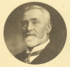
John Bryden was a Scottish-born businessman and political figure in British Columbia, Canada. He represented Nanaimo from 1875 to 1876 and North Nanaimo from 1894 to 1900 in the Legislative Assembly of British Columbia.

The Wellington station located in the Wellington area of Nanaimo, British Columbia, was a flag stop on Via Rail's Dayliner service, which ended in 2011. The station is on the Southern Railway of Vancouver Island mainline. The station was named after the town of Wellington which formed around and next to the Wellington Colliery which was named after Arthur Wellesley, 1st Duke of Wellington, a leading British military and political figure in the 19th century.

Joseph William McKay (Mackay) was a fur trader, businessman, politician and explorer who had a long career in the employ of the Hudson's Bay Company in Canada.

<span class="mw-page-title-main">Nanaimo Harbour</span>

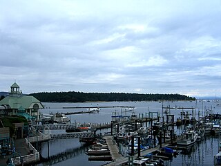
Nanaimo Harbour, also known as the Port of Nanaimo, is a natural harbour on the east coast of Vancouver Island, British Columbia, Canada. The City of Nanaimo runs along the west side of the harbour. Three islands, Newcastle, Protection, and Gabriola, along with Duke Point, form the eastern edge. The Port of Nanaimo includes the Inner Harbour, Nanaimo River estuary, Departure Bay, the waters on the east side of Newcastle and Protection Islands, and Northumberland Channel. The port is under the management of the Nanaimo Port Authority.

Extension is an unincorporated community near the east coast of southern Vancouver Island, British Columbia. The location off BC Highway 19 is about 107 kilometres (66 mi) by road northwest of Victoria, and 10 kilometres (6 mi) south of Nanaimo.

Chase River, known in the Hulquminum language as Kulwulton, is a river on Vancouver Island, British Columbia, Canada, discharging into the Strait of Georgia at the south end of Nanaimo Harbour. It is the namesake of the city of Nanaimo's neighbourhood of Chase River.

Nanaimo, British Columbia had four Chinatown sites beginning in the 1800s.

References

  1. "Nanaimo Archives :: HBC McKay Letters, 1852-1853". www.nanaimoarchives.ca. Retrieved 2019-03-08.
  2. Derek, Pethick (1990), The Nanaimo Mine Disaster of 1887, Canadian West, pp. 68–71
  3. 1 2 3 4 5 6 7 8 9 10 11 12 13 14 15 16 17 Bowen, Lynn (1989), The Dunsmuirs of Nanaimo, Nanaimo, BC: The Nanaimo Festival
  4. "Nanaimo Yesterday and Today", Nanaimo Free Press, 1979-11-25
  5. "Of Flagpoles and Guns", Nanaimo Free Press, 1983-05-27
  6. Hinde, John R. (2003), When coal was king: Ladysmith and the coal-mining industry on Vancouver Island, Vancouver: UBC Press, ISBN   0-7748-0935-3, archived from the original on 2007-11-11, retrieved 2008-07-12
  7. 1 2 3 4 5 6 7 8 9 10 11 12 13 14 15 16 17 18 19 20 21 22 23 24 25 26 27 28 29 30 31 32 33 34 35 36 37 38 39 40 Lindsay, AScT, Shari (2004), Coal Mine Underground Workings Atlas, Nanaimo, BC: Pacific Spatial Systems
  8. Niosi, Goody. "A Walk Through Time". Archived from the original on 2008-02-13. Retrieved 2008-07-02.
  9. Victoria Colonist, May 28, 1915
  10. Burgess, Judy. "The Morden Mine Story" . Retrieved 2008-07-02.