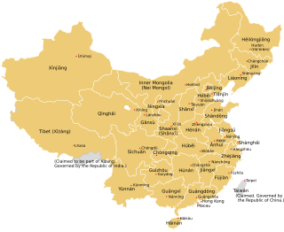
Special administrative regions
List of prefectural-level divisions and list of county-level divisions of the People's Republic of China | ||
|---|---|---|
| Provinces | ||
| Autonomous regions | ||
| Municipalities | ||
| This article is part of a series on |
| Administrative divisions of China |
|---|
History: before 1912, 1912–49, 1949–present Administrative division codes |
County-level divisions are the third level of administration of the People's Republic of China and include counties, autonomous counties, banners, autonomous banners, county-level cities and districts. Most county-level divisions are administered as part of prefecture-level divisions, but some are administered directly by province-level divisions. Among the county-level divisions, this list also includes the Republic of China-controlled Taiwan Province and fractured Fujian Province.
The following lists show all county-level divisions in each province-level division.
The administrative divisions of China have consisted of several levels since ancient times, due to China's large population and geographical area. The constitution of China provides for three levels of government. However in practice, there are five levels of local government; the provincial, prefecture, county, township, and village.
The Republic of China (Taiwan) is divided into multi-layered statutory subdivisions. Due to the complex political status of Taiwan, there is a significant difference in the de jure system set out in the original constitution and the de facto system in use today.

The provincial level administrative divisions are the highest-level administrative divisions of China. There are 34 such divisions claimed by the People's Republic of China, classified as 23 provinces, five autonomous regions, four municipalities and two special administrative regions. The political status of Taiwan Province along with a small fraction of Fujian Province remain in dispute; those are under separate rule by the Republic of China, which is usually referred to as "Taiwan".
ISO 3166-2:CN is the entry for China in ISO 3166-2, part of the ISO 3166 standard published by the International Organization for Standardization (ISO), which defines codes for the names of the principal subdivisions of all countries coded in ISO 3166-1.

An autonomous municipality or city, previously provincial city, are de jure second-level administrative division units in the Republic of China (Taiwan).

In the context of China, the term prefecture is used to refer to several unrelated political divisions in both ancient and modern China.

A league is an administrative unit of the autonomous region of Inner Mongolia in the People's Republic of China.

Chinese autonomous administrative divisions are associated with one or more ethnic minorities that are designated as autonomous within the People's Republic of China. These areas are recognized in the Constitution of the People's Republic of China and are nominally given a number of rights not accorded to other administrative divisions of China. For example, Tibetan minorities in autonomous regions are granted rights and support not given to the Han Chinese, such as fiscal and medical subsidies.
Townships are the third-level administrative subdivisions of counties of the Republic of China (Taiwan), along with county-administered cities. After World War II, the townships were established from the following conversions on the Japanese administrative divisions:

Taiwan Province is a nominal administrative division of the People's Republic of China (PRC). The PRC constitution defines Taiwan as part of its territories despite the fact that the PRC has never controlled any part of Taiwan since the PRC's establishment in 1949. Taiwan is currently administered by the Republic of China (ROC).

Urad Rear Banner or Urad Houqi is a banner of the Inner Mongolia Autonomous Region, People's Republic of China. It is located in the west of the region, 44 kilometres (27 mi) northwest of the city of Bayan Nur, which administers this banner, and borders the Republic of Mongolia's Ömnögovi Province to the north. The banner has a total area of 24,925 km2 (9,624 sq mi) and in 2020 had a population of 53,946. It is located in the prefectural-level municipality of Bayannur city. The capital is moved to the town of Bayinbaolige (巴音宝力格镇). This Banner division is also home to the Upper Cretaceous Bayan Mandahu Formation.

Morin Dawa Daur Autonomous Banner, often abbreviated in official documents as Mo Banner, is one of three autonomous banners in Inner Mongolia, China, created for the Daur people. It lies on the Nen River, borders Heilongjiang province to the east, south and southwest and is under the administration of Hulunbuir City. The autonomous banner spans an area of approximately 10,400 square kilometres (4,000 sq mi), and has a total population of 316,398 as of 2019.
The Administrative division codes of the People's Republic of China identify the administrative divisions of China at county level and above. They are published by the National Bureau of Statistics of China with the latest version issued on September 30, 2015.
The 2000 Chinese census, officially the Fifth National Population Census of the People's Republic of China, was conducted by the government of the People's Republic of China with 1 November 2000 as its zero hour. The total population was calculated as 1,295,330,000. The census also covered population growth, number of households, sex, age, ethnicity, educational attainment, and urban and rural population.