List of demolished places of worship in West Sussex

Last updated

The town-centre site of Bognor Regis's former parish church, St John the Baptist's, has been occupied by shops since the church was demolished in 1972. Site of Former St John's Church, London Road, Bognor Regis.JPG
The town-centre site of Bognor Regis's former parish church, St John the Baptist's, has been occupied by shops since the church was demolished in 1972.
Map all coordinates using: OpenStreetMap

In the English county of West Sussex, many former chapels, churches and other places of worship have been demolished without direct replacement. Declining congregations, structural problems, commercial redevelopment, vandalism and many other reasons have contributed to the loss of more than 80 buildings across the county. Major towns such as Bognor Regis, Littlehampton, Worthing and the cathedral city of Chichester have each lost several religious buildings, while former chapels have also been removed in rural hamlets such as Copsale, Iping Marsh and South Mundham.

Contents

Details of all places of public worship which have been completely demolished without direct replacement on the same site are recorded here. Private, hospital, school, prison and similar chapels are excluded, as are former churches which are ruinous but still extant—such as the derelict building in Bedham which functioned as the hamlet's church and school. [1] Buildings demolished to allow a new church to be constructed on the same site are also excluded; but if a church was pulled down and a replacement was built on a different site, as at Chichester (St Richard's Church) [2] and Burgess Hill (the Baptist church), [3] details of the old building are given.

Many churches listed here were built during the 19th century and demolished after World War II. [4] Although the government's scheme of statutory listing for buildings of special architectural and historic interest had started in the 1940s, it was—with a few exceptions—not until the late 20th century that churches and chapels of the Victorian era began to be given the protection from demolition or significant alteration which listed status confers. By 1980, nearly 80 of the approximately 600 Victorian places of worship across Sussex as a whole had been lost. [4] Many demolition-threatened buildings survived by "pure chance, combined with the laudable initiative of a few private individuals": processes to preserve former churches that were no longer required, coordinated at a denominational or local level, never developed. [5] Fewer places of worship have been lost since about 1980, as charitable bodies such as the Churches Conservation Trust, Friends of Friendless Churches and Historic Chapels Trust have become more influential and local initiatives have had more success. Nevertheless, some churches of considerable architectural merit have been lost, such as the "most distinguished modern church in Crawley" (the European-influenced St Richard's Church at Three Bridges), [6] St John the Baptist's Church in Bognor Regis ("one of the town's few distinctive buildings") [7] and the substantial St Peter's Church at Treyford, often called the Cathedral of the Downs. [8]

Demolished places of worship

Demolished places of worship
NameLocationDistrictDenominationCompletedDemolishedPresent use of siteNotesRefs
Rocks Lane Baptist Chapel Balcombe
51°03′26″N0°08′13″W / 51.0571°N 0.1369°W / 51.0571; -0.1369 (Site of former Rocks Lane Baptist Chapel, Balcombe)
Mid Sussex Baptist 1858c. 1950VacantThis low single-storey weatherboarded building was once a shop, but in 1858 it became a Strict Baptist chapel. Members of the chapel at nearby Cuckfield held services in Balcombe in 1845 and 1846 in a private house, and despite opposition from residents a church was founded in October 1851. The building erected at that time soon became a row of cottages, but a preacher from Brighton acquired the Rocks Lane chapel in 1858 and the congregation moved there. The cause failed in either 1914 or 1924, but the building stood for longer. It was only deregistered as a place of worship in 1970. [9] [10]
[11] [12]
Gospel Hall Billingshurst
51°00′49″N0°27′04″W / 51.0135°N 0.4512°W / 51.0135; -0.4512 (Site of former Gospel Hall, Billingshurst)
Horsham Plymouth Brethren 18881962ResidentialBuilt for Brethren in 1888, this hall was later used by The Salvation Army and a Baptist congregation before passing to the Roman Catholic Church in 1925. It was rededicated as a church, and served the village until the new St Gabriel's Church was built on another site in 1961–62. It had a porch and roughcast walls. The remains of an arcade can still be seen attached to the outer wall of Marycot, the neighbouring house. [13] [14]
[15]
Gingers Chapel Billingshurst Horsham Congregational 18151868John Croucher, the founder of the Congregational cause in Billingshurst, acquired a former officers' mess building from the Napoleonic Wars era and re-erected it as a chapel in 1815. The octagonal structure was used until 1868, when a new church (now Trinity United Reformed Church) was built elsewhere in the village. [13] [16]
St Alban's Chapel Bognor Regis
50°47′13″N0°40′02″W / 50.7870°N 0.6672°W / 50.7870; -0.6672 (Site of former St Alban's Chapel, Bognor Regis)
Arun Anglican 17931857ParklandSir Richard Hotham, the original developer of Bognor, also provided its first Anglican place of worship. In 1793 he built a chapel next to his residence, Bersted Lodge (later called Aldwick Manor). The Duke of St Albans laid the foundation stone. The chapel was granted a licence in 1797 and was used for public services thereafter, but the next owner of the house demolished it soon after buying it. [17] [18]
St John the Evangelist's Church Bognor Regis
50°46′57″N0°40′39″W / 50.7824°N 0.6775°W / 50.7824; -0.6775 (Site of former St John the Evangelist's Church, Bognor Regis)
Arun Anglican 18211891Car parkThe predecessor to St John the Baptist's Church (also now demolished) served as Bognor's parish church between 1873 and 1882. Built speculatively by local man Daniel Wonham, it was a stucco-clad Gothic Revival building with a spacious interior. A tower was built in 1830; this survived the demolition and overlooked The Steyne until 1961, when it too was taken down. [17] [18]
St John the Baptist's Church Bognor Regis
50°47′07″N0°40′27″W / 50.7852°N 0.6741°W / 50.7852; -0.6741 (Site of former St John the Baptist's Church, Bognor Regis)
Arun Anglican 18821972Commercial (Boots) Arthur Blomfield's Early English Gothic Revival church on the main London Road became the town's new parish church upon its completion in 1882. It used flint and red brick and was described as "one of the town's few distinctive buildings", although the Victoria County History of Sussex called it "uninspired". Bognor Regis had another large, central Anglican church (St Wilfrid's), and the Diocese of Chichester declared St John the Baptist's redundant on 8 June 1971. [7] [17]
[18] [19]
St Peter's Church Bognor Regis
50°47′33″N0°41′27″W / 50.7925°N 0.6907°W / 50.7925; -0.6907 (Site of former St Peter's Church, Bognor Regis)
Arun Anglican 19391997ResidentialThis combined hall and church building was at the junction of Gravits Lane and Frith Road within the parish of St Margaret's Church, South Bersted. It was dedicated on 23 August 1939. Planning permission for its demolition and the construction of housing on the site was granted in 1997. [20] [21]
High Street Congregational Church Bognor Regis
50°47′02″N0°40′23″W / 50.7838°N 0.6731°W / 50.7838; -0.6731 (Site of former High Street Congregational Church, Bognor Regis)
Arun Congregational 18661929CommercialThe Snewin Brothers of Littlehampton were responsible for this corner-site chapel in Bognor town centre. It was in the Early English Gothic Revival style, principally of flint with some stonework. The entrance was set in a porch. A larger church (now the United Reformed Church) replaced it on another site in 1930. [17] [18]
Hanover Chapel Bognor Regis
50°47′06″N0°40′29″W / 50.7849°N 0.6746°W / 50.7849; -0.6746 (Site of former Hanover Chapel, Bognor Regis)
Arun Independent 18261966CommercialThis stood on a road (Dorset Gardens) which has also been lost to redevelopment. It was in religious use only until 1869, after which it had many functions including a theatre. [17] [18]
Wesleyan Methodist Chapel Bognor Regis
50°47′00″N0°40′26″W / 50.7834°N 0.6738°W / 50.7834; -0.6738 (Site of former Wesleyan Methodist Chapel, Bognor Regis)
Arun Methodist 18401980CommercialThis chapel was also in secular use for many years after being replaced by a larger building elsewhere in the town. Built in 1840 in the Classical style with a stuccoed façade, it was used for worship for 85 years, but James Withers' replacement church of 1925 superseded it. Until its demolition it was used as a garage. [17] [18]
Primitive Methodist Chapel Bognor Regis
50°46′56″N0°40′42″W / 50.7823°N 0.6783°W / 50.7823; -0.6783 (Site of former Primitive Methodist Chapel, Bognor Regis)
Arun Methodist 18761975ResidentialThis Gothic Revival-style chapel with lancet windows occupied one corner of The Steyne, a central square. It was mostly flint with some red brickwork. In 1932 it became a Plymouth Brethren Gospel Hall, and was still used by this group in 1963. [17] [18]
[22]
Burgess Hill Baptist Tabernacle Burgess Hill
50°57′22″N0°07′58″W / 50.9560°N 0.1327°W / 50.9560; -0.1327 (Site of former Burgess Hill Baptist Church, Burgess Hill)
Mid Sussex Baptist 18941970Commercial (Lidl)E.J. Hamilton designed this church in 1894. The congregation moved to a new building on Station Road in 1965, when the Tabernacle was deregistered for worship, and The Martlets shopping centre development replaced the old church and its surroundings in 1970. It was a Gothic Revival building of red brick and stone. [3] [23]
Chichester Congregational Church Chichester
50°50′04″N0°46′48″W / 50.8345°N 0.7800°W / 50.8345; -0.7800 (Site of former Chichester Congregational Church, Chichester)
Chichester Congregational 18921980CommercialAnother building by E.J. Hamilton, this time in 1892, this was built of ragstone in the Perpendicular Gothic Revival style. One end had an apse. Its marriage registration, granted in October 1892, was cancelled in April 1980. [2] [24]
Christ Church Chichester
50°50′02″N0°46′47″W / 50.8338°N 0.7797°W / 50.8338; -0.7797 (Site of former Christ Church, Chichester)
Chichester Methodist 18761981Commercial (Christ Church Buildings)Like the Congregational church, this stood on South Street and was demolished in the 1980s. The two congregations joined and moved into a new church together in 1982. Alexander Lauder built the church in an Italianate Gothic Revival style in 1876 using Portland stone. The façade was gabled and had small towers. Pevsner described its string-courses as "very rude". [2] [25]
Broyle Road Methodist Chapel Chichester
50°50′36″N0°46′48″W / 50.8434°N 0.7799°W / 50.8434; -0.7799 (Site of former Broyle Road Methodist Chapel, Chichester)
Chichester Methodist 18751965ResidentialThis chapel was in religious use from 1875 until 1956. It was a flint building with red brick dressings and lancet windows. [2]
East Walls Methodist Chapel Chichester
50°50′11″N0°46′20″W / 50.8364°N 0.7722°W / 50.8364; -0.7722 (Site of former East Walls Methodist Chapel, Chichester)
Chichester Methodist 1840c. 1910CommercialA brick chapel in the Vernacular style, this was opened near the city walls in 1840. [2]
St Richard's Church Chichester
50°50′03″N0°46′47″W / 50.8341°N 0.7797°W / 50.8341; -0.7797 (Site of former St Richard's Church, Chichester)
Chichester Roman Catholic 18551958CommercialChichester's first Roman Catholic church was replaced by another with the same dedication on a different site upon its demolition in 1958. William Wardell designed the Early English Gothic Revival building in 1855. It was of flint and stone, and the west end of the roof supported a tall bellcote. [2]
Cinder Hill Mission ChurchCinder Hill, Horsted Keynes Mid Sussex Anglican 1919VacantAt a cost of £85, and with the support of Rev. F.H.D. Smythe (later an Archdeacon of Lewes), a small hut used as a wartime soldiers' church "on the [Sussex] coast" was moved to the hamlet of Cinder Hill in Horsted Keynes parish in 1919. A pre-existing Sunday school moved in, and the building was used intermittently for worship as well. [26]
St Paulinus' ChurchCokeham, Sompting
50°49′57″N0°20′09″W / 50.8326°N 0.3359°W / 50.8326; -0.3359 (Site of former St Paulinus' Church, Cokeham, Sompting)
Adur Roman Catholic 19351973Residential (Hamilton Mews)A Roman Catholic church for the Sompting area was built in the Upper Cokeham suburb in 1935. Registered for marriages between 1941 and 1971, it closed in 1973 and the site was sold for residential development; worshippers joined the church at nearby Lancing. [27] [28]
Mar's Hill Chapel Colgate
51°04′53″N0°14′37″W / 51.0813°N 0.2437°W / 51.0813; -0.2437 (Site of former Mar's Hill Chapel, Colgate)
Horsham Baptist 1890c. 1976ResidentialThis chapel was built for Baptists in 1890; before that, Nonconformist worshippers had to travel to Handcross or Horsham. The building was of brick and had a capacity of 100. [29]
Church of the Holy Nativity Copsale
51°00′42″N0°19′54″W / 51.0117°N 0.3317°W / 51.0117; -0.3317 (Site of former Church of the Holy Nativity, Copsale)
Horsham Anglican 1859c. 1965VacantThis hamlet in the parish of Nuthurst was given a chapel of ease to the parish church in 1859. The dedication was recorded by 1895, and the red-brick Early English-style building was extended in about 1915. It closed and was pulled down in about 1965. [30] [31]
Station Road Baptist Church Crawley
51°06′46″N0°11′24″W / 51.1129°N 0.1899°W / 51.1129; -0.1899 (Site of former Station Road Baptist Church, Crawley)
Crawley Baptist 1893c. 1944Car parkThis chapel, originally ministered by an associate of Charles Spurgeon, was built of red brick and stone, and had arched windows with both round and segmental heads, an apse and a porch. Bomb damage in 1943 resulted in its demolition. A replacement building was erected in the West Green neighbourhood in 1954. [32] [33]
Bethel Strict Baptist Chapel Crawley
51°06′48″N0°11′36″W / 51.1133°N 0.1932°W / 51.1133; -0.1932 (Site of former Bethel Strict Baptist Chapel, Crawley)
Crawley Baptist 18582003Commercial (Asda) Strict Baptists met in a cottage at Three Bridges from about 1810, and an 80-capacity chapel and burial ground were built on Robinson Road in 1858. Closure came in 1969, but members of the Cuckfield Baptist Church helped reopen it (as Crawley Reformed Baptist Church) in 1971. The building was stuccoed and had an entrance porch with a date-stone. [32] [33]
[34] [35]
Trinity Congregational Church Crawley
51°06′48″N0°11′31″W / 51.1133°N 0.1920°W / 51.1133; -0.1920 (Site of former Trinity Congregational Church, Crawley)
Crawley Congregational 18631962Commercial (Asda)The first Congregational chapel on the site, on Robinson Road near the railway station, opened in 1835. This brick Early English-style church replaced it in 1863, and was used until a replacement with the same name was built in the Ifield neighbourhood in 1962. [32] [33]
[36]
St Mary's Church Duncton
50°56′24″N0°38′10″W / 50.9400°N 0.6361°W / 50.9400; -0.6361 (Site of former St Mary's Church, Duncton)
Chichester Anglican a. 15481876VacantSt Mary was originally a chapel of ease to Petworth, but it became a separate parish in 1692. The church was replaced as the parish church by Holy Trinity to the north of the village in 1866 and demolished in 1876. [37]
New Life Church Durrington
50°50′07″N0°24′26″W / 50.8354°N 0.4073°W / 50.8354; -0.4073 (Site of former New Life Church, Durrington)
Worthing Baptist 19392022ResidentialThis church acquired its name in 1985 but has its origins in a Free Church of 1912 which became Baptist in 1943. The original chapel, designed by James E. Lund, was superseded by a brick building completed in 1939 to the design of E. Brian Tyler. The church received planning permission for a new, much larger building on the West Durrington estate, and was also granted permission to sell their chapel for demolition and residential replacement. [38] [39]
[17] [40]
[41]
St Michael's Church Durrington
50°50′24″N0°24′11″W / 50.8401°N 0.4031°W / 50.8401; -0.4031 (Site of former St Michael's Church, Durrington)
Worthing Roman Catholic 19381966ResidentialDurrington's Roman Catholic parish was constituted in 1927. The first chapel, on Cotswold Road, was erected in 1938. It closed and was demolished when a replacement building was put up on Hayling Rise in 1966. [42]
St Luke's Church East Grinstead
51°08′14″N0°00′02″W / 51.1373°N 0.0005°W / 51.1373; -0.0005 (Site of former St Luke's Church, East Grinstead)
Mid Sussex Anglican 19542015ResidentialThis opened as the third church in the parish of St Swithun's Church in 1954 and served the Stone Quarry estate in the north of East Grinstead. Architect E.F. Starling's design used brown and yellow brick and featured a large area of glass in one wall. A church hall was integrated into the building. The last service took place on the last Sunday of June 2014, after which the church closed; it was demolished in 2015 with permission for residential redevelopment. Church services transferred to the chapel at Queen Victoria Hospital at first. [43] [44]
[45] [46]
Providence Chapel East Grinstead
51°07′48″N0°01′00″W / 51.1299°N 0.0167°W / 51.1299; -0.0167 (Site of former Providence Chapel, East Grinstead)
Mid Sussex Baptist 1894c. 1967Car parkThis red-brick chapel had bands and dressings of stone on the façade and was in the Early English Gothic Revival style. The cause was established by members of Forest Fold Chapel at Crowborough, and trustee James Cooper funded it. It closed before 1967. [35] [47]
[48]
Rocks Chapel East Grinstead Mid Sussex Congregational 1850A group of seceders from the Zion Baptist Chapel embraced Congregationalism and founded this chapel. They later opened the larger Moat Chapel nearby, and the building passed to Methodists for a time. [47]
London Road Methodist Church East Grinstead
51°07′30″N0°00′37″W / 51.1250°N 0.0104°W / 51.1250; -0.0104 (Site of former London Road Methodist Church, East Grinstead)
Mid Sussex Methodist 18811937CommercialEast Grinstead's first Wesleyan Methodist church was built of stone in the Decorated Gothic Revival in 1881 by S.W. Haughton. It was superseded by Trinity Methodist Church nearby. [47]
Emmanuel Church East Worthing
50°49′01″N0°21′03″W / 50.8169°N 0.3507°W / 50.8169; -0.3507 (Site of former Emmanuel Church, East Worthing)
Worthing Anglican 19772008Residential (Emmanuel Court) Diocesan Architect J.C.L. Iredell's octagonal brick church superseded the original Emmanuel Church (adjacent to the east). This prefabricated building with lancet windows and a bellcote was put up in 1911 by the brother of the vicar of St George's Church, to which Emmanuel Church was a chapel of ease. The original building became the church hall; but both were bought and demolished for a housing development. [49] [50]
[51]
Mission Hall Elsted Marsh
50°58′46″N0°48′41″W / 50.9795°N 0.8115°W / 50.9795; -0.8115 (Site of former Mission Hall, Elsted Marsh)
Chichester Nondenominational c. 1884c. 1971ResidentialThis mission hall near Elsted railway station was registered for worship in 1884. [52]
Dependants' Chapel Felpham
50°47′43″N0°38′12″W / 50.7954°N 0.6366°W / 50.7954; -0.6366 (Site of former Dependants' Chapel, Felpham)
Arun Society of Dependants c. 1898c. 1939Car parkThis small localised sect erected an iron building on Flansham Lane for their services, which were latterly held on Wednesdays. For a time in the 1930s it was shared with Methodists until they built their permanent church in 1939. [53]
Primitive Methodist Chapel Fishbourne
50°50′08″N0°48′37″W / 50.8355°N 0.8103°W / 50.8355; -0.8103 (Site of former Primitive Methodist Chapel, Fishbourne)
Chichester Methodist 18721971ResidentialFishbourne's Methodist chapel was a red-brick building with bargeboards and lancet windows. It was demolished for housing. [54]
Fishersgate Particular Baptist ChapelFishersgate
50°49′55″N0°13′04″W / 50.8319°N 0.2178°W / 50.8319; -0.2178 (Site of former Fishersgate Particular Baptist Chapel, Fishersgate)
Adur Baptist 1868c. 1960IndustrialThis chapel at the end of Chapel Road closed in the 1890s but still stood until the area was redeveloped for industry. [55] [56]
Congregational ChurchFishersgate
50°49′56″N0°13′09″W / 50.8322°N 0.2193°W / 50.8322; -0.2193 (Site of former Congregational Church, Fishersgate)
Adur Congregational 1879c. 1950IndustrialA building was put up on the north side of Chapel Road in 1879. Originally non-denominational, it later passed to the Congregational Church, but was superseded by a chapel behind West Street in about 1910. The building remained, though, until industrial development took place in the area. [55]
Congregational Mission RoomFishersgate
50°49′58″N0°13′24″W / 50.8327°N 0.2232°W / 50.8327; -0.2232 (Site of former Congregational Mission Room, Fishersgate)
Adur Congregational c. 19102002VacantApparently built to replace the old Congregational church 200 yards (180 m) away, this survived in religious use only until 1947. After that it became a community hall until its demolition. [55] [57]
Mission Room Fontwell
50°51′14″N0°38′39″W / 50.8539°N 0.6442°W / 50.8539; -0.6442 (Site of former Mission Room, Fontwell)
Arun Anglican 1930p. 1974ResidentialThis Anglican mission chapel was served from St Mary's Church at Walberton. It was also used for various social activities and survived until 1974 or later despite falling out of religious use in about 1957. [58] [59]
Church of the Good ShepherdFranklands Village, Haywards Heath
50°59′48″N0°05′09″W / 50.9968°N 0.0857°W / 50.9968; -0.0857 (Site of former Church of the Good Shepherd, Haywards Heath)
Mid Sussex Anglican 19642016VacantThis church was designed by William Newman (who also worked on the Church of the Ascension in Haywards Heath) in 1964–65. It had a steep roof with gables which had large areas of glass. The walls were of cedar wood. It was declared redundant in 2003 and remained empty and disused until it was demolished in 2016. [60] [61]
[62]
St John the Baptist's ChapelFreshfield, Horsted Keynes
51°00′48″N0°01′51″W / 51.0132°N 0.0309°W / 51.0132; -0.0309 (Site of former St John the Baptist's Chapel, Freshfield)
Mid Sussex Anglican 1897c. 1967VacantOriginally known as Freshfield Mission Church, this was built at a cost of £140 on donated land in the hamlet of Freshfield, in the south of the parish of St Giles' Church, Horsted Keynes. The Archdeacon of Lewes dedicated it on 15 November 1897. In 1939 it was said to be "used for occasional services" and a Sunday school. [63]
Goring and Ferring Free Church Goring-by-Sea
50°48′54″N0°25′59″W / 50.8150°N 0.4331°W / 50.8150; -0.4331 (Site of former Goring and Ferring Free Church, Goring-by-Sea)
Worthing Evangelical 19501986Residential (Oakland Court)Described as a "plain brick hall", this was erected on Goring Street in 1950 for an Evangelical group aligned to the FIEC. The Fellowship withdrew support for the minister in 1977, resulting in the closure of the church and a High Court action. The building was pulled down, the site was sold for redevelopment and both parties were awarded a share of the proceeds. [64]
St Wilfrid's Mission Church Hambrook
50°51′15″N0°52′43″W / 50.8541°N 0.8786°W / 50.8541; -0.8786 (Site of former St Wilfrid's Mission Church, Hambrook)
Chichester Anglican 1923c. 1973ResidentialThis was a chapel of ease to St Mary's Church in Chidham. It still stood in 1973, but was later replaced with a new church with the same dedication in the Nutbourne area of Hambrook, a short distance to the south. [65] [66]
Primitive Methodist Mission Room Horsham
51°04′10″N0°19′54″W / 51.0694°N 0.3316°W / 51.0694; -0.3316 (Site of former Primitive Methodist Mission Room, Horsham)
Horsham Methodist 18852018ResidentialSeveral Primitive Methodist chapels were founded in the Horsham area in the late 19th century. This brick building on Rushams Road in the northwest of the town dated from 1885; it closed by the early 1920s. It was later acquired by the British Red Cross and was used for the provision of mobility aids, but in August 2016 it was announced that the centre would be closed and the building sold. It was demolished for housing. [67] [68]
[69] [70]
St John the Evangelist's Chapel Horsham
51°03′49″N0°19′55″W / 51.0636°N 0.3319°W / 51.0636; -0.3319 (Site of former St John the Evangelist's Chapel, Horsham)
Horsham Roman Catholic 1865c. 1983CommercialThis replaced Horsham's first Roman Catholic place of worship—a castellated building on Springfield Road which was owned by the Duke of Norfolk. The new Gothic Revival sandstone church, designed by Matthew Ellison Hadfield, was put up in front of it in 1865 on behalf of the Duchess of Norfolk. There was a shingle-covered bellcote above the entrance. Another new church with the same dedication was built opposite in 1923; Hadfield's building closed and was "altered for commercial use" before being demolished. [71] [72]
St Edward and St Louis ChurchImberhorne, East Grinstead
51°07′39″N0°01′53″W / 51.1274°N 0.0314°W / 51.1274; -0.0314 (Site of former St Edward and St Louis Church, Imberhorne, East Grinstead)
Mid Sussex Roman Catholic 18791955Residential Edward Blount KCB bought the Imberhorne Estate near East Grinstead in 1877. His family were devout Roman Catholics, but the nearest place of worship was the Friary Church in Crawley; so they converted part of Imberhorne House into a chapel for themselves and the public. It was East Grinstead's Catholic parish church for 20 years, and a gallery was built in 1889 to extend the capacity. The last Mass was on 12 June 1955, many fittings were moved to a new church at Forest Row, and the house and chapel were demolished following vandalism. A housing estate occupies the site. [73] [74]
Church of the Good Shepherd Iping Marsh
51°01′21″N0°47′39″W / 51.0225°N 0.7943°W / 51.0225; -0.7943 (Site of former Church of the Good Shepherd, Iping Marsh)
Chichester Anglican 18781986VacantThis isolated church near Midhurst was closed in 1977 due to vandalism, although it was not declared redundant until 1 November 1980. Permission for its demolition was granted in 1981, although the graveyard was preserved. Also known as the Knapp Church, it was designed by E.P.L. Brock in the Early English style using black and red brick. There was a bellcote and a porch. [5] [19]
[73]
Kingdom Hall Lancing
50°49′49″N0°19′35″W / 50.8303°N 0.3265°W / 50.8303; -0.3265 (Site of former Kingdom Hall, Lancing)
Adur Jehovah's Witnesses 19602011ResidentialThis Kingdom Hall was built in 1960 to serve the Lancing Congregation of Jehovah's Witnesses. In 2009, planning permission was granted for the site to be redeveloped with housing, and it has been replaced by a new building in Leconfield Road. [75] [76]
[77] [78]
Brethren Meeting Room Lancing
50°50′07″N0°19′07″W / 50.8352°N 0.3187°W / 50.8352; -0.3187 (Site of former Brethren Meeting Room, Lancing)
Adur Plymouth Brethren Christian Church c. 1977c. 2019VacantAlso known as First Avenue Hall, the original building on the site was the Exclusive Brethren community of Lancing's first permanent place of worship. It stood behind First Avenue and was later rebuilt. After the split in the Exclusive Brethren movement in 1970, it went on to be used by the group which became known as the Plymouth Brethren Christian Church. [76] [79]
[80]
St John's Chapel Littlehampton
50°48′29″N0°32′39″W / 50.8081°N 0.5442°W / 50.8081; -0.5442 (Site of former St John's Church, Littlehampton)
Arun Anglican 18771976Car park Seceders from St Mary's Church, the town's parish church, established a new place of worship in 1877. William White designed a timber-built Early English Gothic Revival chapel. It remained unconsecrated until its closure in 1948, after which it was a theatre for many years. [81]
Argyll Hall Littlehampton
50°48′31″N0°32′40″W / 50.8087°N 0.5445°W / 50.8087; -0.5445 (Site of former Argyll Hall, Littlehampton)
Arun Plymouth Brethren c. 19502004Residential (Argyll Hall)Brethren occupied this building next to the River Arun by 1950, when the congregation was about 160. It went out of religious use after Parkside Evangelical Church was founded elsewhere in the town in 1973. Although the council stated they wanted to demolish Argyll Hall to build a road, this did not happen; the site was eventually cleared in 2004 and new housing (also called Argyll Hall) was put up in its place. [82] [83]
St Saviour's Free Episcopal Church Littlehampton
50°48′30″N0°32′27″W / 50.8082°N 0.5407°W / 50.8082; -0.5407 (Site of former St Saviour's Free Episcopal Church, Littlehampton)
Arun Reformed Episcopal 18771981Residential (Church House)Local builders Snewin Brothers erected this chapel in 1877 for the Free Episcopal Church of England to the design of M.E. Habershon and E.P.L. Brock. Their Early English Gothic Revival design used red and yellow brick, flint and stone. In 1896, the Littlehampton Methodist Society paid £860 (equivalent to £105,900in 2021) for the building, having outgrown their chapel in Terminus Road. At the time it was used as a theatre: the Episcopal congregation had left in 1887. Another £618 was spent on refurbishment and an extension, and an organ was installed in the apse at a cost of £150. A church hall was added in 1915. The chapel closed in 1980 and the congregation moved into the United Reformed Church nearby, which is now styled "United Church". [81] [84]
[85]
Terminus Road Methodist Chapel Littlehampton
50°48′34″N0°32′42″W / 50.8095°N 0.5451°W / 50.8095; -0.5451 (Site of former Terminus Road Methodist Chapel, Littlehampton)
Arun Methodist 18261982Commercial (Sergeant Pepper's Amusements and Snack Bar)Organised Methodist worship in the town dates back to 1816, when a Society was formed and services were held in houses. In 1825, it bought a site on Terminus Road for £155.7s.6d. (equivalent to £13,600in 2021) and built a chapel at a cost of £482.5s.6d. (equivalent to £42,100in 2021). This opened the following year and was used until 1898, when the congregation moved to the former St Saviour's Church. The Classical-style stuccoed building became a shop; until its demolition a prominent ball-shaped finial could still be seen on top. [81] [86]
[85]
Lodsworth Chapel Lodsworth
51°00′09″N0°40′57″W / 51.0025°N 0.6824°W / 51.0025; -0.6824 (Site of former Lodsworth Chapel, Lodsworth)
Chichester Congregational c. 1865a. 1962GarageThis "little Congregational chapel" on the edge of Trussler's Heath in this village between Petworth and Midhurst was erected by a shopkeeper called Mrs Farthing. Registered for marriages between 1865 and 1943, it was demolished by the early 1960s. [87] [88]
[89]
Congregational Temple Midhurst
50°59′07″N0°44′25″W / 50.9854°N 0.7404°W / 50.9854; -0.7404 (Site of former Congregational Temple, Midhurst)
Chichester Congregational 19071946Residential (Russell Court)This octagonal Free Renaissance Revival-style brick and stone church opened in Midhurst town centre in 1907. It was wrecked by bombing in 1942 and was demolished without replacement. Worshippers entered through a tall portico of stone columns. The roof was topped with a cupola with louvres. [90]
Independent Chapel Rogate
51°00′26″N0°51′07″W / 51.0072°N 0.8519°W / 51.0072; -0.8519 (Site of former Independent Chapel, Rogate)
Chichester Congregational 1826ResidentialOpened in 1826 for Independent Christians, this chapel later changed its character to adopt Congregationalism. It stood on School Lane in the hamlet of Rogate. [91]
First Church of Christ, Scientist, Rustington Rustington
50°48′40″N0°30′51″W / 50.8111°N 0.5142°W / 50.8111; -0.5142 (Site of former First Church of Christ Scientist, Rustington)
Arun Christian Scientist 2007Residential (Chestnut Cottages)There was a Christian Scientist presence on The Street by 1962, when their reading room was sold to the Jehovah's Witnesses and converted into a Kingdom Hall. The single-storey church nearby was demolished and the site sold for residential development. [92] [93]
Rustington Methodist Chapel Rustington
50°48′37″N0°30′21″W / 50.8103°N 0.5059°W / 50.8103; -0.5059 (Site of former Rustington Methodist Chapel, Rustington)
Arun Methodist 18771952RoadFounded by Primitive Methodists who had previously worshipped at a cottage, this chapel was originally a smithy. It was turned into an 80-capacity chapel in 1877, and was used until it was bought and pulled down in 1952 to allow the adjacent road to be widened. A large church was built to replace it at nearby Claigmar Road. [92] [94]
New Road Wesleyan Chapel Shoreham-by-Sea
50°49′58″N0°16′17″W / 50.8327°N 0.2715°W / 50.8327; -0.2715 (Site of former New Road Wesleyan Chapel, Shoreham-by-Sea)
Adur Methodist 1829c. 1921ResidentialShoreham's first Wesleyan chapel had a capacity of 200 worshippers. Soon the congregation moved to a new church nearby in 1900, and The Salvation Army re-registered the building as their place of worship. It went out of religious use in or before 1921. [95]
Primitive Methodist Chapel Shoreham-by-Sea
50°49′54″N0°16′35″W / 50.8318°N 0.2764°W / 50.8318; -0.2764 (Site of former Primitive Methodist Chapel, Shoreham-by-Sea)
Adur Methodist 18791937Commercial Primitive Methodism became established in the town in the early 19th century. Meetings were held in various rooms and secular buildings, but in 1879 the group built a chapel near the town hall on High Street. It was used for worship until 1935, and was an Early English Gothic Revival structure with pinnacles and a stuccoed exterior. The marriage registration was cancelled in November 1935. [95] [96]
[97]
Small Dole Baptist Church Small Dole
50°54′09″N0°16′28″W / 50.9024°N 0.2745°W / 50.9024; -0.2745 (Site of former Small Dole Baptist Church, Small Dole)
Horsham Baptist 18801983ResidentialA red-brick chapel on the main road through Small Dole served the area's Baptists from 1880 until 1977, when it was closed and converted into the village hall. A new hall was built on another site after 1981, and the original building was demolished in 1983. [96] [98]
[99]
Zion Bible Christian Chapel South Mundham
50°47′32″N0°45′54″W / 50.7923°N 0.7649°W / 50.7923; -0.7649 (Site of former Zion Bible Christian Chapel, South Mundham)
Chichester Methodist 18211959VacantFounded for Bible Christian Methodists by John Leng near the hamlet of South Mundham, this opened in 1821 and was extended in 1893. It went out of use in 1939. [96]
Southwater Wesleyan Chapel Southwater
51°01′57″N0°21′06″W / 51.0326°N 0.3518°W / 51.0326; -0.3518 (Site of former Southwater Wesleyan Chapel, Southwater)
Horsham Methodist 1884c. 1930ResidentialThis Methodist church was founded in 1884 and had a capacity of 80. The red-brick building fell out of religious use in 1930. [67] [100]
All Souls Centre Southwick
50°50′36″N0°13′54″W / 50.8434°N 0.2318°W / 50.8434; -0.2318 (Site of former All Souls Centre, Southwick)
Adur Anglican 1955c. 2012ResidentialThis combined church and nursery school was built in 1955 on the site of a mission hall linked to the Church Army movement. It was sold, with permission to redevelop the site for housing, in 2008. [55] [75]
[101]
Primitive Methodist Mission Hall Southwick
50°49′54″N0°14′17″W / 50.8318°N 0.2381°W / 50.8318; -0.2381 (Site of former Primitive Methodist Mission Hall, Southwick)
Adur Methodist 1879c. 1964ResidentialLock Road (no longer in existence) had a hall which was registered for Primitive Methodist worship between 1879 and 1906 and then for Plymouth Brethren between 1921 and 1964. [55]
Southwick Wesleyan Methodist Chapel Southwick
50°49′54″N0°14′11″W / 50.8316°N 0.2365°W / 50.8316; -0.2365 (Site of former Southwick Wesleyan Methodist Chapel, Southwick)
Adur Methodist 18761962ResidentialThe present Methodist church in Southwick was built on Southwick Street in 1965 as an extension to a 1930s hall. John Lund's chapel of 1876, closed in 1955, was on Albion Street. It was an Early English Gothic Revival stone building with a capacity of 240, and was linked to the Brighton Circuit. [55] [100]
Seamen's Institute Mission Hall Southwick
50°49′53″N0°14′25″W / 50.8315°N 0.2402°W / 50.8315; -0.2402 (Site of former Seamen's Institute Mission Hall, Southwick)
Adur Nondenominational c. 19031981IndustrialThis hall was used for Christian worship between 1903 and 1957. The two-storey Institute building, which had a three-window range and paired entrance porches, also had a reading room and other facilities. It later became a public library. [55] [102]
[103]
St Richard of Chichester's Church Three Bridges
51°07′04″N0°10′27″W / 51.1177°N 0.1743°W / 51.1177; -0.1743 (Site of former St Richard of Chichester's Church, Three Bridges)
Crawley Anglican 19541994ResidentialStructural problems caused Crawley's "most distinguished modern church" to be demolished after just 40 years. N.F. Cachemaille-Day incorporated continental European and Scandinavian architectural themes into his Modernist brick design of 1952–54, which featured a nave, a central altar and a cubic sanctuary. This had a portico and was topped with a glazed rotunda. A hall adjoined the church. The building was declared redundant from 1 January 1994, and a new St Richard's Church opened on an adjacent site in 1995. [19] [32]
[6] [104]
St Peter's Church Treyford
50°57′53″N0°49′47″W / 50.9646°N 0.8298°W / 50.9646; -0.8298 (Site of former St Peter's Church, Treyford)
Chichester Anglican 18491951VacantTreyford's medieval church was superseded in 1849 by the so-called "Cathedral of the Downs"—Benjamin Ferrey's gigantic flint and stone Decorated Gothic Revival building which was also intended to replace Didling and Elsted's parish churches. Its corner tower was topped with a spire. The church did not thrive and suffered structural problems—the stone used may have been clunch, which weathers badly, and repairs were needed in the 1880s. It was destroyed with explosives in 1951. [105] [106]
[107]
Upper Beeding Mission Hall Upper Beeding
50°52′07″N0°17′54″W / 50.8686°N 0.2982°W / 50.8686; -0.2982 (Site of former Upper Beeding Mission Hall, Upper Beeding)
Horsham Anglican c. 1909c. 1960VacantA tin tabernacle was erected in or before 1909 to serve the houses around the cement works in the south of Upper Beeding parish. The site was sold and the chapel demolished in the 1960s. It had a single bell, which was removed prior to demolition. [108] [109]
Free Church West Chiltington Common
50°56′47″N0°27′39″W / 50.9464°N 0.4607°W / 50.9464; -0.4607 (Site of former Free Church, West Chiltington Common)
Horsham Congregational c. 1925c. 1970ResidentialOriginally a mission hall and subsequently registered in December 1925 by Congregationalists, this had its worship registration cancelled on 7 December 1970. [110] [111]
Sanatan Mandir West Green
51°06′49″N0°11′46″W / 51.1136°N 0.1961°W / 51.1136; -0.1961 (Site of former Sanatan Mandir Hindu Temple, West Green, Crawley)
Crawley Hindu 2019Residential (Spencers Place)The Gurjar Hindu Union of Crawley, established in 1968, moved to this small temple and community centre in 1997. The community started building a new temple and community centre at a site in Ifield in 2008, and moved to it upon its completion in 2010. [112] [113]
[114]
St Michael and All Angels ChurchWest Meads, Aldwick
50°47′21″N0°42′04″W / 50.7891°N 0.7012°W / 50.7891; -0.7012 (Site of former St Michael and All Angels Church, West Meads, Aldwick)
Arun Anglican 19682015Residential (Jubilee Terrace)This church was founded on the West Meads housing estate in 1968, but it fell out of use in 2006. A planning application for its demolition was refused in March 2011—at which time the building was owned by Christ for the Nations, an Evangelical group—but demolition was subsequently authorised and the derelict building was replaced with a terrace of houses in 2015. [115] [116]
[117] [118]
[119] [120]
Second Church of Christ, Scientist, Worthing West Worthing
50°49′03″N0°23′43″W / 50.8175°N 0.3953°W / 50.8175; -0.3953 (Site of former Second Church of Christ, Scientist, West Worthing)
Worthing Christian Scientist 19602015Religious (Kingdom Hall)The Church of Christ, Scientist established a presence in West Worthing in 1938. Its reading room was replaced by a church—a modern brick structure—in 1960 after many years of planning. The congregation from the First Church of Christ, Scientist elsewhere in Worthing joined in 1987 when that church closed. In September 2010 the West Worthing church was also closed; houses were planned for the site in April 2011, but in 2013 a planning application for a Kingdom Hall of Jehovah's Witnesses was approved, and construction took place in 2015. The Second Church of Christ, Scientist's registration for worship was formally cancelled in October 2015. [38] [121]
[122] [123]
[124]
Cuckfield Methodist Chapel Whiteman's Green
51°00′48″N0°08′29″W / 51.0134°N 0.1413°W / 51.0134; -0.1413 (Site of former Cuckfield Methodist Chapel, Whiteman's Green)
Mid Sussex Methodist c. 1886c. 1960ResidentialThis chapel, on the London Road north of Cuckfield village, served the area's Wesleyan Methodist population. It was one of six places of worship in the parish (three Anglican, one Baptist and one Congregationalist). The building was sold in the early 1950s. [125] [126]
Wick Methodist Chapel Wick
50°49′09″N0°32′39″W / 50.8191°N 0.5443°W / 50.8191; -0.5443 (Site of former Wick Methodist Chapel, Wick)
Arun Methodist 18761968Commercial (Wick Parade)This was built in the northern suburbs of Littlehampton in 1876 and was originally Primitive Methodist. After the Methodist Union of 1932, it was linked to the formerly Wesleyan Littlehampton Methodist Church in New Road. The Gothic Revival building had flint and brick walls. [127] [128]
[129]
Wyndham Mission Room Wineham
50°58′03″N0°14′30″W / 50.9676°N 0.2418°W / 50.9676; -0.2418 (Site of former Wyndham Mission Room, Wineham)
Horsham Anglican 1891c. 1947ResidentialWineham (usually called Wyndham until the 20th century) is a village in the east of Shermanbury parish, distant from its church. An iron-walled chapel of ease was erected near the Royal Oak inn on Wineham Lane in 1891. It was used for worship until around 1938 and still stood for some years afterwards. [130] [131]
Church of the Good Shepherd Worthing
50°48′57″N0°22′15″W / 50.8159°N 0.3709°W / 50.8159; -0.3709 (Site of former Church of the Good Shepherd, Worthing)
Worthing Anglican 19061973Charitable organisation (Methold House)F.C. Cook's Early English Gothic Revival-style chapel of ease to the nearby St Paul's Church opened in 1906 and fell out of use in 1963. It had stone-dressed stuccoed walls. The Worthing Area Guild for Voluntary Services, a charity with wide-ranging activities, has been based in the vicinity since 1933; in 1975, after the church was demolished, they built a new headquarters on the site. [49] [50]
[132]
Brighton Road Meeting Room Worthing
50°48′44″N0°21′52″W / 50.8123°N 0.3645°W / 50.8123; -0.3645 (Site of former Brighton Road Meeting Room, Worthing)
Worthing Baptist 18861965Commercial (The Bike Store)Used by Calvinistic Baptists, this stood at 65 Brighton Road. [38] [121]
Gospel Hall Worthing
50°48′44″N0°22′13″W / 50.8123°N 0.3702°W / 50.8123; -0.3702 (Site of former Gospel Hall, Worthing)
Worthing Plymouth Brethren 1887c. 1918CommercialThis was registered as a Brethren meeting hall in 1892, five years after its construction. It stood at 12 Chapel Road for about 30 years, but was demolished after its closure in 1918. [38] [39]
Independent Congregational Chapel Worthing
50°48′37″N0°22′22″W / 50.8104°N 0.3729°W / 50.8104; -0.3729 (Site of former Independent Congregational Chapel, Worthing)
Worthing Congregational 18391978Commercial (Boots)Local architect Charles Hide rebuilt the Independent chapel of 1804 on Montague Street which had been Worthing's first place of worship, pre-dating even St Paul's Anglican Church. The new building was used by Congregationalists led by Rev. George E. Rees. The Christian Literary Institute was opened in 1862 next to the church, but when a new Congregational church was built on Shelley Road in 1898 the chapel fell out of religious use: it was converted into a hall and, later, shops. A Boots store now occupies the site. [38] [133]
Evangelical Protestants' Hall Worthing
50°49′19″N0°22′08″W / 50.8219°N 0.3688°W / 50.8219; -0.3688 (Site of former Evangelical Protestant Chapel, Worthing)
Worthing Evangelical 19061969Commercial (Guildbourne Centre)James E. Lund, who also designed Worthing Tabernacle and West Worthing Evangelical Free Church, was responsible for the free-style Queen Anne Revival chapel on Chatsworth Road which was used by displaced members of the former New Street Chapel. Its pastor served for 51 years, but in 1957 it was sold and became a factory. Its marriage registration, which dated from 1909, was cancelled in May of that year. [38] [121]
[134]
Primitive Methodist Chapel Worthing
50°48′57″N0°22′20″W / 50.8159°N 0.3723°W / 50.8159; -0.3723 (Site of former Primitive Methodist Chapel, Worthing)
Worthing Methodist 18921958Commercial (Worthing Bedding Centre)A tin tabernacle of 1880 at the junction of Wenban Road and Chapel Road was later replaced by R.S. Hyde's Decorated Gothic Revival church of red brick, flint and stone. Architectural features included a flèche and an apse. It closed in 1955 or 1956. [38] [133]

All Saints Church, Baldwins Hill

Between 1887 and the 1960s, a church dedicated to All Saints [135] stood at a location ( 51°08′18″N0°01′13″W / 51.1382°N 0.0202°W / 51.1382; -0.0202 ) which is now within West Sussex but which was part of neighbouring Surrey at the time. [note 1] Sidney Poole Lowell of Baldwins, a large house north of East Grinstead, paid for the church to be built near his house because of the distance from St Swithun's parish church. St Mary the Virgin's church was later built nearby, but the older building—originally dedicated to St Matthias—still stood. Because it was just over the county border in Surrey, it was part of the Anglican Diocese of Southwark and was not linked to the new church. This situation was changed in 1952, when the renamed All Saints Church was transferred to the Diocese of Chichester and became a second church within St Mary the Virgin's parish. Nine years later, it was closed because of structural defects; the church committee concluded it "no longer serv[ed] any useful purpose". [135]

See also

Notes

  1. The county boundary was changed by the Local Government Act 1972. Ordnance Survey maps before this date show the boundary running south of Felbridge Lane, the road on which the church stood. [136] [137]

Related Research Articles

<span class="mw-page-title-main">West Sussex</span> County of England

West Sussex is a ceremonial county in South East England. It is bordered by Surrey to the north, East Sussex to the east, the English Channel to the south, and Hampshire to the west. The largest settlement is Crawley, and the county town is the city of Chichester.

<span class="mw-page-title-main">West Green, West Sussex</span> Human settlement in England

West Green is one of the 14 residential neighbourhoods in Crawley, a town and borough in West Sussex, England. Crawley was planned and laid out as a New Town after the Second World War, based on the principle of self-contained neighbourhoods surrounding a town centre of civic and commercial buildings. West Green was the first neighbourhood to be developed, and is one of the smallest and closest to the town centre.

<span class="mw-page-title-main">Buncton</span> Human settlement in England

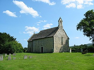
Buncton is a small village in the Horsham District of West Sussex, England, part of the civil parish of Wiston 0.5 miles (0.80 km) north. It lies to the east of the A24 road, 11 miles (18 km) as the crow flies, about 18 miles (29 km) by road south of Horsham and 6 miles (9.7 km) north west of Shoreham by Sea.

<span class="mw-page-title-main">Rape of Bramber</span>

The Rape of Bramber is one of the rapes, the traditional sub-divisions unique to the historic county of Sussex in England. It is the smallest Sussex rape by area. Bramber is a former barony whose original seat was the castle of Bramber and its village, overlooking the river Adur.

<span class="mw-page-title-main">St Peter's Church, Shoreham-by-Sea</span> Historic site in West Sussex , England

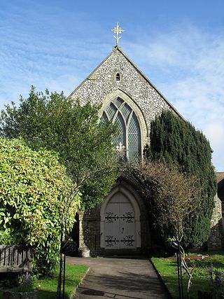
The name St Peter's Church has been borne by two Roman Catholic churches in the town of Shoreham-by-Sea in the district of Adur, in the English county of West Sussex. The original church with that dedication was the town's first permanent Roman Catholic place of worship; founded in 1875, it was paid for by Augusta, Duchess of Norfolk, a member of the most important Dukedom in England. After its closure, a new St Peter's Church was built nearby. The old building, which still stands and is in residential use, has been listed by English Heritage at Grade II for its architectural and historical importance.

<span class="mw-page-title-main">St George's Church, Worthing</span> Church in West Sussex , England

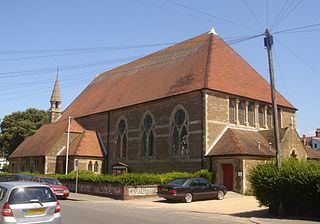
St George's Church is an Anglican church in the East Worthing area of the borough of Worthing, one of seven local government districts in the English county of West Sussex. Built in 1867–68 to serve new residential development in the southeast of the town, the Decorated Gothic-style structure was extended later in the 19th century, and expanded its reach further by founding three mission halls elsewhere in Worthing. English Heritage has listed it at Grade C for its architectural and historical importance.

<span class="mw-page-title-main">Friary Church of St Francis and St Anthony, Crawley</span> Church in West Sussex , United Kingdom

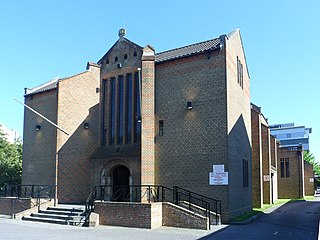
The Friary Church of St Francis and St Anthony is a Roman Catholic church in Crawley, a town and borough in West Sussex, England. The town's first permanent place of Roman Catholic worship was founded in 1861 next to a friary whose members, from the Order of Friars Minor Capuchin, had been invited to the area by a wealthy local family of Catholic converts. Crawley's transformation from a modest market town to a rapidly growing postwar New Town in the mid-20th century made a larger church necessary, and in the late 1950s the ecclesiastical architect Harry Stuart Goodhart-Rendel was commissioned to build a new church. The friary closed in 1980 and has been demolished, but the large brick church still stands in a commanding position facing the town centre. English Heritage has listed the building at Grade II for its architectural and historical importance.

<span class="mw-page-title-main">All Saints Church, Roffey</span> Church in West Sussex , United Kingdom

All Saints Church is the Anglican parish church of Roffey, in the Horsham district of the English county of West Sussex. The present church, built to serve the Victorian suburb of Roffey—part of the ancient market town of Horsham—replaced a schoolroom in which religious services had been held since 1856. Arthur Blomfield's Early English-style church, built of locally quarried sandstone and funded by a widow as a memorial to her late husband, was completed in 1878 and was allocated a parish immediately. Roman Catholic services were also held in the building to serve Roffey's Catholic population, but these ceased in the early 21st century. English Heritage has listed the church at Grade II for its architectural and historical importance.

<span class="mw-page-title-main">Jarvis Hall, Steyning</span> Church in West Sussex , United Kingdom

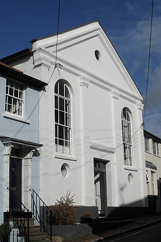
Jarvis Hall is a former Nonconformist chapel in the village of Steyning, in the Horsham district of the English county of West Sussex. Since its construction in 1835, the Classical-style building has been used by four different Nonconformist Christian denominations: the Countess of Huntingdon's Connexion, Wesleyan Methodists, the Salvation Army and Plymouth Brethren. The Brethren occupied it last and for the longest time. After about 150 years of religious use, it was sold for residential conversion. English Heritage has listed the former chapel at Grade II for its architectural and historical importance.

<span class="mw-page-title-main">Steyning Methodist Church</span> Church in West Sussex, United Kingdom

Steyning Methodist Church is a Methodist place of worship serving Steyning and surrounding villages in the Horsham district of West Sussex, England. Built for a Wesleyan Methodist congregation who had outgrown an earlier chapel nearby, the Gothic Revival building opened in 1878 and has since been extended. The flint and yellow brick church is set back from Steyning's ancient High Street and is within the village conservation area. It is one of nine churches in the Worthing Methodist Circuit.

<span class="mw-page-title-main">Madina Mosque, Horsham</span> Mosque in West Sussex, England

Madina Mosque is a mosque in the centre of Horsham, an ancient market town in the English county of West Sussex. It has served the Muslim community of the town and the surrounding district of Horsham since 2008. The plain stuccoed building in which it is housed was originally a Baptist chapel—one of several in the town, which has a long history of Nonconformist Christian worship. The former Jireh Independent Chapel was in commercial use until Muslims acquired it after a lengthy search for a permanent space. The organization, 'Muslims in Britain' classify the Madina Mosque as, "Deobandi".

<span class="mw-page-title-main">St Michael and All Angels Church, Partridge Green</span> Church in West Sussex, United Kingdom

St Michael and All Angels Church is a late nineteenth-century church in the settlement of Partridge Green in the parish of West Grinstead in West Sussex. It was built to cater for the then growing population of the village. Ian Nairn, in the Sussex volume of The Buildings of England, approves of the simplicity of this "flint village church" and comments that most "other counties would have had it much fussier". St Michael and All Angels' shares its mission with the parish church of St George's Church, West Grinstead.

<span class="mw-page-title-main">Horsham Friends Meeting House</span> Church in West Sussex , United Kingdom

Horsham Friends Meeting House is a Religious Society of Friends (Quaker) place of worship in the town of Horsham, part of the district of the same name in West Sussex, England. It was built in 1786 to replace a meeting house nearly 100 years older on the same site, built for a Quaker community which had been active in the town for several years. "A fine Georgian building with original furnishings", it has Grade II listed status.

References

  1. Elleray 2004 , p. 3.
  2. 1 2 3 4 5 6 Elleray 2004 , p. 16.
  3. 1 2 Elleray 2004 , p. 14.
  4. 1 2 Elleray 1981 , p. 33.
  5. 1 2 Elleray 1981 , p. 34.
  6. 1 2 Allen, John (6 December 2010). "Crawley - St Richard, Three Bridges". Sussex Parish Churches website. sussexparishchurches.org. Retrieved 3 September 2011.
  7. 1 2 Elleray 1981 , §25.
  8. Elleray 1981 , §188.
  9. Elleray 2004 , p. 2.
  10. Chambers 1953 , pp. 111–112.
  11. Homan 1997 , p. 280.
  12. "No. 45260". The London Gazette . 29 December 1970. p. 14075.
  13. 1 2 Elleray 2004 , p. 4.
  14. Lines 1995 , p. 88.
  15. Lines 2002 , p. 47.
  16. Lines 1995 , p. 86.
  17. 1 2 3 4 5 6 7 8 Elleray 2004 , p. 5.
  18. 1 2 3 4 5 6 7 Salzman, L.F., ed. (1953). "A History of the County of Sussex: Volume 4 – The Rape of Chichester. Bognor Regis". Victoria County History of Sussex. British History Online. pp. 226–227. Retrieved 4 September 2011.
  19. 1 2 3 "The Church of England Statistics & Information: Lists (by diocese) of closed church buildings. Diocese of Chichester" (PDF). Church of England. 21 February 2011. Archived from the original (PDF) on 16 May 2012. Retrieved 5 November 2020.
  20. "South Bersted (Par/19): Souvenir programme (Par/19/4/12) (1939)". Summary of records at East Sussex Record Office. The National Archives. 2011. Retrieved 20 September 2011.
  21. "Officers Report: BR/46/97". Planning Application BR/46/97. Arun District Council. 14 November 1997. Retrieved 20 September 2011.
  22. Trowbridge, W.H. (1998–2012) [1963]. "List of Meetings Great Britain and Ireland – 1963". MyBrethren.org website (History and Ministry of the early "Exclusive Brethren" (so-called) – their origin, progress and testimony 1827–1959 and onward). Hampton Wick: The Stow Hill Bible and Tract Depot. Archived from the original on 26 October 2020. Retrieved 4 January 2021.
  23. "No. 43749". The London Gazette . 27 August 1965. p. 8213.
  24. "No. 48173". The London Gazette . 30 April 1980. p. 6484.
  25. Nairn & Pevsner 1965 , pp. 171–172.
  26. Stenton Eardley 1939 , p. 140.
  27. Hudson, T. P., ed. (1980). "A History of the County of Sussex: Volume 6 Part 1 – Bramber Rape (Southern Part). Sompting". Victoria County History of Sussex. British History Online. pp. 122–125. Retrieved 18 September 2011.
  28. "No. 45282". The London Gazette . 15 January 1971. p. 632.
  29. Hudson, T. P., ed. (1987). "A History of the County of Sussex: Volume 6 Part 3 – Bramber Rape (North-Eastern Part) including Crawley New Town. Lower Beeding – Nonconformity". Victoria County History of Sussex. British History Online. p. 28. Retrieved 19 September 2011.
  30. Elleray 2004 , p. 17.
  31. Hudson, T. P., ed. (1987). "A History of the County of Sussex: Volume 6 Part 3 – Bramber Rape (North-Eastern Part) including Crawley New Town. Nuthurst – Church". Victoria County History of Sussex. British History Online. pp. 106–108. Retrieved 4 September 2011.
  32. 1 2 3 4 Elleray 2004 , p. 18.
  33. 1 2 3 Hudson, T. P., ed. (1987). "A History of the County of Sussex: Volume 6 Part 3 – Bramber Rape (North-Eastern Part) including Crawley New Town. Ifield: Protestant nonconformity". Victoria County History of Sussex. British History Online. pp. 71–72. Retrieved 4 September 2011.
  34. Chambers 1953 , p. 10.
  35. 1 2 Homan 1997 , p. 281.
  36. "No. 42988". The London Gazette . 7 May 1963. p. 3963.
  37. Wilcox 2004 , p. 129.
  38. 1 2 3 4 5 6 7 Hudson, T. P., ed. (1980). "A History of the County of Sussex: Volume 6 Part 1 – Bramber Rape (Southern Part). Worthing – Protestant Nonconformity". Victoria County History of Sussex. British History Online. pp. 122–125. Retrieved 18 September 2011.
  39. 1 2 Elleray 1998 , p. 52.
  40. "New Church Building Fundraising". New Life Worthing. 2023. Archived from the original on 1 June 2023. Retrieved 23 October 2023.
  41. "Durrington New Life Church demolition plans up for decision". Sussex Express. National World Publishing Ltd. 15 November 2018. Archived from the original on 23 October 2023. Retrieved 23 October 2023.
  42. Hudson, T. P., ed. (1980). "A History of the County of Sussex: Volume 6 Part 1 – Bramber Rape (Southern Part). Worthing – Roman Catholicism". Victoria County History of Sussex. British History Online. p. 122. Retrieved 19 September 2011.
  43. Allen, John (2024). "East Grinstead – St Luke, Stone Quarry". Sussex Parish Churches website. Sussex Parish Churches (www.sussexparishchurches.org). Archived from the original on 8 June 2023. Retrieved 15 January 2024.
  44. "St Luke, East Grinstead". A Church Near You website. Archbishops' Council. 2009. Retrieved 12 June 2009.
  45. Leppard 2001 , pp. 160–161.
  46. "Last service at St Luke's". East Grinstead Online. 2 July 2014. Archived from the original on 2 March 2016. Retrieved 15 January 2024.
  47. 1 2 3 Elleray 2004 , p. 23.
  48. Chambers 1953 , pp. 9–10.
  49. 1 2 Elleray 2004 , p. 56.
  50. 1 2 Elleray 1998 , p. 48.
  51. "Worthing church facing the bulldozers". Chichester Observer. Johnston Press Digital Publishing. 25 April 2008. Retrieved 26 September 2011.
  52. "No. 45471". The London Gazette . 14 September 1971. p. 9923.
  53. Hudson, T. P., ed. (1997). "A History of the County of Sussex: Volume 5 Part 1 – Arundel Rape (south-western part including Arundel). Felpham". Victoria County History of Sussex. British History Online. pp. 160–182. Retrieved 16 April 2012.
  54. Elleray 2004 , p. 24.
  55. 1 2 3 4 5 6 7 Hudson, T. P., ed. (1980). "A History of the County of Sussex: Volume 6 Part 1 – Bramber Rape (Southern Part). Southwick". Victoria County History of Sussex. British History Online. pp. 42–44. Retrieved 18 September 2011.
  56. Homan 1997 , p. 278.
  57. Painter, Jackie (26 September 2007). "Fishersgate: The Last Ten Years (or so)". Jackie's Place website. Spanglefish.com. Archived from the original on 27 September 2012. Retrieved 16 March 2013.
  58. Hudson, T. P., ed. (1997). "A History of the County of Sussex: Volume 5 Part 1: Arundel Rape (southwestern part) including Arundel. Walberton". Victoria County History of Sussex. British History Online. pp. 224–244. Retrieved 16 May 2013.
  59. (Map). 1:2500. Cartography by Ordnance Survey. old-maps.co.uk (Historical Map Archive). 1974 http://www.old-maps.co.uk/maptiles/t100954_495516_106938.png . Retrieved 16 May 2013.{{cite map}}: Missing or empty |title= (help)
  60. Allen, John (2014). "Haywards Heath – Good Shepherd". Sussex Parish Churches website. Sussex Parish Churches (www.sussexparishchurches.org). Archived from the original on 8 June 2023. Retrieved 15 January 2024.
  61. Allen, John (8 June 2009). "Architects and Artists N–O". Sussex Parish Churches website. Sussex Parish Churches (www.sussexparishchurches.org). Archived from the original on 13 October 2008. Retrieved 12 June 2009.
  62. Jackson 2005 , p. 84.
  63. Stenton Eardley 1939 , p. 139.
  64. Elleray 1998 , p. 53.
  65. "Chidham and Hambrook – The Churches". The Chidham and Hambrook Website Association. 2012. Archived from the original on 14 February 2012. Retrieved 4 March 2012.
  66. Allen, John (13 December 2010). "Hambrook – St Wilfrid". Sussex Parish Churches website. Sussex Parish Churches (www.sussexparishchurches.org). Archived from the original on 4 March 2016. Retrieved 4 March 2012.
  67. 1 2 Hudson, T. P., ed. (1986). "A History of the County of Sussex: Volume 6 Part 2 – Bramber Rape (North-Western Part) including Horsham. Horsham – Protestant Nonconformity". Victoria County History of Sussex. British History Online. pp. 196–198. Retrieved 28 January 2024.
  68. Elleray 2004 , p. 33.
  69. Various authors 2007 , p. 13.
  70. Oxenham, James (11 August 2016). "Red Cross to close Horsham centre". Crawley and Horley Observer. Johnston Press Digital Publishing. Archived from the original on 12 August 2016. Retrieved 12 August 2016.
  71. Elleray 2004 , p. 32.
  72. Hudson, T. P., ed. (1986). "A History of the County of Sussex: Volume 6 Part 2 – Bramber Rape (North-Western Part) including Horsham. Horsham – Roman Catholicism". Victoria County History of Sussex. British History Online. pp. 195–196. Retrieved 4 September 2011.
  73. 1 2 Elleray 2004 , p. 37.
  74. Smith, John G. (1997). "Blounts of Imberhorne". Felbridge & District History Group. Retrieved 22 September 2011.
  75. 1 2 "Churches, religions and current places of worship". Adur District Council. 1 November 2005. Archived from the original on 17 December 2009. Retrieved 9 July 2009.
  76. 1 2 Hudson, T. P., ed. (1980). "A History of the County of Sussex: Volume 6 Part 1 – Bramber Rape (Southern Part). Lancing". Victoria County History of Sussex. British History Online. pp. 34–53. Retrieved 7 April 2015.
  77. "Application Summary (ADC/0036/09)". Adur District Council planning application. Adur District Council/CAPS Solutions Ltd. 26 January 2009. Archived from the original on 6 June 2022. Retrieved 7 April 2015. Redevelopment with 6 one-bedroom dwellings with 3 parking spaces (accessed from east side of Wembley Gardens) (outline with access details): Kingdom Hall, Wembley Gardens, Lancing, West Sussex
  78. Registered in accordance with the Places of Worship Registration Act 1855 (Number in Worship Register: 71500; Name: Kingdom Hall; Address: Wembley Gardens, Wembley Avenue, Lancing; Denomination: Jehovah's Witnesses). Retrieved 22 October 2012. ( Archived version of list from April 2010 ; subsequent updates )
  79. Registered in accordance with the Places of Worship Registration Act 1855 (Number in Worship Register: 74826; Name: Meeting Room; Address: Rear of Dorset Lodge, First Avenue, Lancing; Denomination: Christians not otherwise designated; Date deregistered (as recorded on original certificate): 20 May 2019). Retrieved 22 October 2012. ( Archived version of list from April 2010 ; subsequent updates ; original certificate held at The National Archives in folio RG70/150)
  80. "No. 62646". The London Gazette . 20 May 2019. p. 8952.
  81. 1 2 3 Elleray 2004 , p. 39.
  82. Lewis 2009 , p. 202.
  83. "Our History". Parkside Evangelical Church. 2011. Archived from the original on 24 March 2012. Retrieved 22 May 2011.
  84. s.n. 1980 , pp. 5–7.
  85. 1 2 UK Retail Price Index inflation figures are based on data from Clark, Gregory (2017). "The Annual RPI and Average Earnings for Britain, 1209 to Present (New Series)". MeasuringWorth. Retrieved 11 June 2022.
  86. s.n. 1980 , pp. 3–5.
  87. "No. 23035". The London Gazette . 10 November 1865. p. 5250.
  88. "No. 36242". The London Gazette . 9 November 1943. p. 4932.
  89. Lamb, Wilfrid (2012) [1962]. "Notes for a History of Lodsworth" (PDF). p. 16. Retrieved 4 January 2013.
  90. Elleray 2004 , p. 41.
  91. Elleray 2004 , p. 46.
  92. 1 2 Lewis 2009 , p. 299.
  93. "Chestnut Cottages". Isted Building Services Ltd. 2008. Retrieved 4 September 2011.
  94. Elleray 2004 , p. 47.
  95. 1 2 Hudson, T. P., ed. (1980). "A History of the County of Sussex: Volume 6 Part 1 – Bramber Rape (Southern Part). Old and New Shoreham – Protestant Nonconformity". Victoria County History of Sussex. British History Online. pp. 171–172. Retrieved 20 September 2011.
  96. 1 2 3 Elleray 2004 , p. 50.
  97. "No. 34228". The London Gazette . 6 December 1935. p. 7809.
  98. Hudson, T. P., ed. (1987). "A History of the County of Sussex: Volume 6 Part 3 – Bramber Rape (North-Eastern Part) including Crawley New Town. Upper Beeding – Protestant Nonconformity". Victoria County History of Sussex. British History Online. pp. 44–45. Retrieved 9 September 2011.
  99. Elleray 1981 , p. 79.
  100. 1 2 Elleray 2004 , p. 51.
  101. "Application Details (ADC/0021/09)". Adur District Council planning application. Adur District Council/CAPS Solutions Ltd. 2009. Retrieved 7 October 2009.[ permanent dead link ]
  102. "Seamen's Institute Mission Halls, Albion Street, Southwick c1930 PP_SHORM_89.568". The Shoreham-by-Sea History Portal. Sussex Archaeological Society Photo Archive/ShorehambySea.com. Retrieved 19 September 2011.
  103. "No. 41200". The London Gazette . 11 October 1957. p. 5943.
  104. Nairn & Pevsner 1965 , p. 205.
  105. Elleray 2004 , p. 52.
  106. Nairn & Pevsner 1965 , p. 355.
  107. Allen, John (11 April 2011). "Treyford - St Mary (old and new)". Sussex Parish Churches website. sussexparishchurches.org. Retrieved 18 September 2011.
  108. Hudson, T. P., ed. (1987). "A History of the County of Sussex: Volume 6 Part 3 – Bramber Rape (North-Eastern Part) including Crawley New Town. Upper Beeding – Church". Victoria County History of Sussex. British History Online. pp. 42–44. Retrieved 9 September 2011.
  109. "Upper Beeding, Mission Hall, Sussex". Sussex Bells and Belfries website (based on the book by George P. Elphick). Mike Fradd. 2004.
  110. "No. 45253". The London Gazette . 15 December 1970. p. 13690.
  111. Registered in accordance with the Places of Worship Registration Act 1855 (Number in Worship Register: 50091; Name: Free Church; Address: West Chiltington Common, West Chiltington; Denomination: Congregationalists; Date deregistered (as recorded on original certificate): 7 December 1970). Retrieved 18 August 2022. ( Archived version of list from April 2010 ; subsequent updates ; original certificate held at The National Archives in folio RG70/101)
  112. "History of GHU – The Journey". Gurjar Hindu Union (Apple Tree Centre). 2012. Archived from the original on 12 August 2013. Retrieved 30 January 2013.
  113. "Faith, Belief & Culture Guide" (PDF). Crawley Borough Council Faith, Belief and Culture Guide. Crawley Borough Council and Crawley Interfaith Network. October 2008. Archived (PDF) from the original on 4 March 2016. Retrieved 29 January 2013.
  114. "Grand opening for Crawley Hindu temple". Crawley News/thisiscrawley.co.uk website. East Surrey & Sussex News and Media Ltd. 26 May 2010. Archived from the original on 30 January 2013. Retrieved 30 January 2013.
  115. Endacott, Sylvia (1999–2009). "Bognor Regis Local History Information: Churches". Bognor Regis Local History Group. Archived from the original on 20 March 2011. Retrieved 22 May 2011.
  116. "Residents win fight to stop West Meads homes". Bognor Regis Observer. Johnston Publishing Ltd. 23 March 2011. Retrieved 23 May 2011.
  117. "MIS Weekly Report: Week Start 20/12/2010" (PDF). West Sussex County Council planning applications: week commencing 20 December 2010. West Sussex County Council. 23 December 2010. p. 1. Retrieved 23 May 2011.
  118. "The Parish Church of St Richard, Aldwick: Bell Tower". The Parish Church of St Richard, Aldwick. 2010. Retrieved 23 May 2011.
  119. "Firms line up to buy Royal Norfolk". Bognor Regis Observer. Johnston Publishing Ltd. 5 September 2008. Retrieved 23 May 2011.
  120. "Parish Design Statement" (PDF). Aldwick Parish Council. 2015. p. 68. Archived (PDF) from the original on 3 November 2021. Retrieved 29 January 2024.
  121. 1 2 3 Elleray 1998 , p. 55.
  122. "Homes planned for Worthing church". Worthing Herald. Johnston Publishing Ltd. 4 April 2011. Archived from the original on 13 March 2016. Retrieved 21 May 2013.
  123. "Application for Planning Permission, Town and Country Planning Act 1990 (AWDM/0137/13)" (PDF). Adur & Worthing Councils. 4 February 2013. Archived from the original (PDF) on 21 May 2013. Retrieved 21 May 2013. Demolition of existing building and construction of a new single storey place of worship D1 with 26 parking spaces: Christian Science Church 117 Grand Avenue Worthing West Sussex BN11 5BE
  124. "No. 61385". The London Gazette . 19 October 2015. p. 19671.
  125. "Wesleyan Methodist Chapel, Cuckfield (Mid Sussex Circuit) NMB/6 [n.d.]". Summary of records at East Sussex Record Office. The National Archives. 2011. Retrieved 16 September 2011.
  126. Salzman, L. F., ed. (1940). "A History of the County of Sussex: Volume 7 – The Rape of Lewes. Parishes: Cuckfield". Victoria County History of Sussex. British History Online. pp. 147–163. Retrieved 16 September 2011.
  127. Elleray 2004 , p. 55.
  128. s.n. 1980 , p. 10.
  129. "No. 45455". The London Gazette . 24 August 1971. p. 9218.
  130. Hudson, T. P., ed. (1987). "A History of the County of Sussex: Volume 6 Part 3 – Bramber Rape (North-Eastern Part) including Crawley New Town. Shermanbury". Victoria County History of Sussex. British History Online. pp. 189–192. Retrieved 9 September 2011.
  131. Hudson, T. P., ed. (1987). "A History of the County of Sussex: Volume 6 Part 3 – Bramber Rape (North-Eastern Part) including Crawley New Town. Shermanbury – Church". Victoria County History of Sussex. British History Online. pp. 196–198. Retrieved 9 September 2011.
  132. Elleray 1998 , p. 101.
  133. 1 2 Elleray 1998 , p. 54.
  134. "No. 41067". The London Gazette . 10 May 1957. p. 2807.
  135. 1 2 "St Mary's had a Daughter Church". St Mary the Virgin, East Grinstead. 2008. Retrieved 16 October 2012.
  136. (Map). 1:2500. Cartography by Ordnance Survey. old-maps.co.uk (Historical Map Archive). 1962 http://www.old-maps.co.uk/maptiles/t100955_538602_139494.png . Retrieved 16 October 2012.{{cite map}}: Missing or empty |title= (help)
  137. Review of non-Metropolitan counties: County of West Sussex and its Boundary with Surrey (PDF). LGBCE Report No. 589 (Report). Local Government Boundary Commission for England. 26 April 1990. §§. 23, 66. Archived from the original (PDF) on 17 October 2013. Retrieved 16 March 2013.

Bibliography