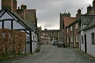
Great Budworth is a village and civil parish in Cheshire, England, four miles (6.4 km) north of Northwich off the A559 road, east of Comberbach, northwest of Higher Marston and southeast of Budworth Heath. Until 1948, Great Budworth was part of the Arley Hall estate.
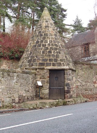
A village lock-up is a historic building once used for the temporary detention of people in England and Wales, mostly where official prisons or criminal courts were beyond easy walking distance. Lockups were often used for the confinement of drunks, who were usually released the next day, or to hold people being brought before the local magistrate. The archetypal form comprises a small room with a single door and a narrow slit window, grating or holes. Most lock-ups feature a tiled or stone-built dome or spire as a roof and are built from brick, stone and/or timber.
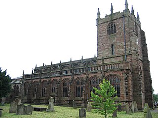
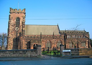
St Boniface's Church stands prominently in the village of Bunbury, Cheshire, England. It is recorded in the National Heritage List for England as a designated Grade I listed building. The church dates mainly from the 14th century. Its features include the Ridley chapel, the alabaster chest tomb of Sir Hugh Calveley and the tomb of Sir George Beeston. Raymond Richards, author of Old Cheshire Churches, considers it is architecturally one of the most important examples of its period in Cheshire. Alec Clifton-Taylor includes it in his list of 'best' English parish churches, and Simon Jenkins assigns it two stars in his book England's Thousand Best Churches. It is an active Anglican parish church in the diocese of Chester, the archdeaconry of Chester and the deanery of Malpas. Its benefice is combined with that of St Jude, Tilstone Fearnall.
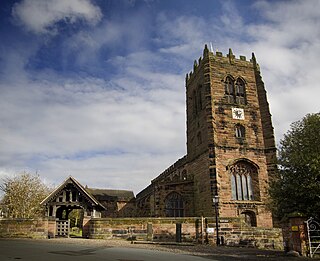
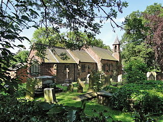
St Mary and All Saints Church is in the centre of the village of Great Budworth, Cheshire, England. It is an active Anglican parish church in the diocese of Chester, the archdeaconry of Chester and the deanery of Great Budworth. The church is recorded in the National Heritage List for England as a designated Grade I listed building. Clifton-Taylor includes it in his list of 'best' English parish churches. Richards describes it as "one of the finest examples of ecclesiastical architecture remaining in Cheshire". The authors of the Buildings of England series express the opinion that it is "one of the most satisfactory Perpendicular churches of Cheshire and its setting brings its qualities out to perfection".

Poole is a civil parish in the unitary authority of Cheshire East and the ceremonial county of Cheshire, England, which lies to the north west of Nantwich and to the west of Crewe. The Shropshire Union Canal runs through the parish. Nearby villages include Acton, Aston juxta Mondrum, Barbridge, Stoke Bank, Rease Heath and Worleston.
St Luke's Church is in the village of Lower Whitley, in the civil parish of Whitley, Cheshire, England. The church is recorded in the National Heritage List for England as a designated Grade II* listed building. It is an active Anglican parish church in the diocese of Chester, the archdeaconry of Chester and the deanery of Great Budworth. It is one of three parish churches in the parish of Aston-by-Sutton, Little Leigh and Lower Whitley. The other two being St Peter, Aston-by-Sutton and St Michael and All Angels, Little Leigh. The three were previously individual parishes in a united benefice with St Mark, Antrobus.

St Peter's Church is in the village of Little Budworth, Cheshire, England. The church is recorded in the National Heritage List for England as a designated Grade II* listed building. It is an active Anglican parish church in the diocese of Chester, the archdeaconry of Chester and the deanery of Middlewich. Its benefice is combined with that of St Mary, Whitegate. The church stands on the highest point in the village and its tower dominates views of the area.
The Grade I listed buildings in Cheshire, excluding those in the city of Chester, total around 80. Almost half of these are churches that are contained in a separate list.

An animal pound is a place where stray livestock were impounded. Animals were kept in a dedicated enclosure, until claimed by their owners, or sold to cover the costs of impounding.
Cheshire is a county in North West England. In 1974 parts of the historical county of Cheshire were transferred to Greater Manchester and to Merseyside, and parts of the historical county of Lancashire were incorporated into Cheshire, including the towns of Widnes and Warrington. The unitary authorities of Halton and Warrington were created in 1998, and in 2009 the rest of the county was divided into two further unitary authorities: Cheshire East, and Cheshire West and Chester. The ceremonial county of Cheshire consists of those four unitary authorities.
Great Budworth is a civil parish in Cheshire West and Chester, England. The parish contains 59 buildings that are recorded in the National Heritage List for England as designated listed buildings. Other than the village of Great Budworth, the parish is entirely rural. Most of the listed buildings are houses, or buildings relating to farming, a high proportion of which are located within the village itself. The village is described by Norman Bilsborough as being "probably one of the best-known villages in Cheshire", and Claire Hartwell et al. writing about the village in the Buildings of England series state "the immediate surroundings of the church make one of the best pieces of villagescape in the county". The village is located in what was part of the estate of Arley Hall. Between the 1860s and the end of the 19th century the owner of the hall, Rowland Egerton-Warburton, commissioned the restoration of existing buildings in the village and the construction of new ones. To this end he employed architects working in the Vernacular Revival style, including John Douglas, Edmund Kirby, and William Eden Nesfield. Douglas' biographer Edward Hubbard states that Egerton-Warburton had a "campaign to restore the village and render it picturesque in Victorian eyes". Almost all the buildings in the centre of the village, those in Main Street, Church Street, and School Lane, are listed.
Little Budworth is a civil parish in Cheshire West and Chester, England. It contains 18 buildings that are recorded in the National Heritage List for England as designated listed buildings. Of these, four are listed at Grade II*, and the others at Grade II. Other than the village of Little Budworth, the parish is completely rural, and this is reflected in its listed buildings. These are all domestic or related to farming, other than the village church, a memorial, the entrance gates to the former Oulton Park House, a pinfold, and the plague stone.
There are over 20,000 Grade II* listed buildings in England. This page is a list of these buildings in the unitary authority of Cheshire West and Chester.
There are over 9,000 Grade I listed buildings in England. This page is a list of these buildings in the unitary authority of Cheshire West and Chester.
Aston by Budworth is a civil parish in Cheshire East, England. It contains 32 buildings that are recorded in the National Heritage List for England as designated listed buildings. Of these, one is listed at Grade I, the highest grade, three are listed at Grade II*, the middle grade, and the others are at Grade II. The major building in the parish is Arley Hall; this, together with a number of associated structures, is listed. Otherwise the parish is entirely rural, and the listed buildings are mainly houses, farmhouses, and farm buildings.
Gawsworth is a civil parish in Cheshire East, England. It contains 20 buildings that are recorded in the National Heritage List for England as designated listed buildings. Of these, three are listed at Grade I, the highest grade, two are listed at Grade II*, the middle grade, and the others are at Grade II. Apart from the village of Gawsworth, the parish is rural. The most important buildings in the parish, all listed at Grade I, are Gawsworth Old Hall and associated structures, St James' Church, also with associated structures, and the Old Rectory. Listed at Grade II* are Gawsworth New Hall and an associated barn. The Macclesfield Canal runs through the parish, and there are three listed structures associated with this, two bridges and a milestone. The other listed buildings are houses, farm buildings, a grave, a public house, a war memorial, and a boundary stone.
Henbury is a civil parish in Cheshire East, England. It contains 25 buildings that are recorded in the National Heritage List for England as designated listed buildings, all of which are at Grade II. This grade is the lowest of the three gradings given to listed buildings and is applied to "buildings of national importance and special interest". The parish contains the village of Henbury, and Henbury Hall with its grounds, but is otherwise rural. Most of the listed buildings are houses, cottages, farmhouses, farm buildings and associated structures. Also listed are buildings associated with Henbury Hall. The other listed structures include a church and its lychgate, a pinfold, and a milepost.
Poole is a civil parish in Cheshire East, England. It contains eight buildings that are recorded in the National Heritage List for England as designated listed buildings. Of these, one is listed at Grade II*, the middle grade, and the others are at Grade II. The parish is rural, and the listed buildings consist of a country house with an associated barn, farmhouses and farm buildings, a cottage, a bridge, a pinfold, and a chapel.


