List of federal highways in Brazil

Last updated

MapaBrasilRodoviasRadiais.png
Radial highways in Brazil highlighted in red
MapaBrasilRodoviasLongitudinais.png
North-south highways in Brazil highlighted in red

This is a list of the federal highways in Brazil. The current numbering system has existed since 1964, with changes in 1973. [1] [2] [3]

Contents

Brazilian federal road names are composed of the ISO 3166 code "BR", a dash and three numbers. State highways in the country are classified as YY-XXX, where YY is the abbreviation of the state where the highway is located and XXX is a number. The first digit in the number determines which of the five categories the National Road System divides it into.

Radial highways

BR-0X0 – starts at the DF-001 in the Federal District and head towards the extremes of the country. Radial highways are identified by the first digit "0", and the other two vary between 10 and 90, always in multiples of ten, each one heading in a different direction clockwise from the DF-001. The direction of the distance starts from the DF-001, with the kilometre zero of each state being at the point of the highway closest to the federal capital. There are nine federal radial highways, including the BR-090, which has not yet been completed. [4] [5]

NumberLength (km) [6] Length (mi)Southern or western terminusNorthern or eastern terminusFormedRemovedNotes
BR-010 jct.svg BR-010 1954.11,214.2Engenheiro Bernardo Sayã Highway
BR-020 jct.svg BR-020 2038.51,266.7
BR-030 jct.svg BR-030 1158.0719.5
BR-040 jct.svg BR-040 1139.3707.9
BR-050 jct.svg BR-050 1025.3637.1
BR-060 jct.svg BR-060 1329.3826.0
BR-070 jct.svg BR-070 1317.7818.8
BR-080 jct.svg BR-080 623.8387.6
BR-090 jct.svg BR-090

North-south highways

NumberLength (km) [7] Length (mi)Southern or western terminusNorthern or eastern terminusFormedRemovedNotes
BR-101 jct.svg BR-101 4551.42,828.1 São José do Norte, RS Touros, RNTranslitorânea/Governador Mário Covas Highway
BR-104 jct.svg BR-104 672.3417.7
BR-110 jct.svg BR-110 1091.1678.0
BR-116 jct.svg BR-116 4566.52,837.5 Jaguarão, RS Fortaleza, CEPresidente Dutra Highway
BR-120 jct.svg BR-120 964.5599.3
BR-122 jct.svg BR-122 1839.71,143.1
BR-135 jct.svg BR-135 2518.51,564.9
BR-146 jct.svg BR-146 678.7421.7
BR-153 jct.svg BR-153 3566.32,216.0 Aceguá, RS São Domingos do Araguaia, PATransbrasiliana Highway
BR-154 jct.svg BR-154 470.3292.2
BR-155 jct.svg BR-155
BR-156 jct.svg BR-156 805.0500.2
BR-158 jct.svg BR-158 3955.02,457.5 Santana do Livramento, RS Altamira, PA
BR-163 jct.svg BR-163 4426.72,750.6 Tenente Portela, RS Santarém, PA
BR-174 jct.svg BR-174 2798.41,738.8

East-west highways

BR-2XX – crosses the country in an east–west direction. The distance of these highways is always measured in this direction. The numbering ranges from 00 to 50 in the section that goes from the extreme north of the country to Brasilia, and from 50 to 99 between the capital and the extreme south. [4]

NumberLength (km) [8] Length (mi)Southern or western terminusNorthern or eastern terminusFormedRemovedNotes
BR-210 jct.svg BR-210 2454.71,525.3North Perimeter
BR-222 jct.svg BR-222 1819.81,130.8
BR-226 jct.svg BR-226 1673.01,039.6
BR-230 jct.svg BR-230 4965.13,085.2
BR-232 jct.svg BR-232 553.5343.9
BR-235 jct.svg BR-235 2093.51,300.8
BR-242 jct.svg BR-242 2295.51,426.4 Milton Santos Highway
BR-251 jct.svg BR-251 2481.11,541.7Julio Garcia Highway
BR-259 jct.svg BR-259 704.4437.7
BR-262 jct.svg BR-262 2295.41,426.3
BR-265 jct.svg BR-265 966.4600.5
BR-267 jct.svg BR-267 1921.91,194.2
BR-272 jct.svg BR-272 904.0561.7
BR-277 jct.svg BR-277 736.6457.7Great Highway
BR-280 jct.svg BR-280 642.2399.0
BR-282 jct.svg BR-282 678.0421.3
BR-285 jct.svg BR-285 355.5220.9 São Borja, RS Araranguá, SC
BR-287 jct.svg BR-287 749.6465.8 São Borja, RS Canoas, RSIntegration Highway
BR-290 jct.svg BR-290 729.7453.4 Uruguaiana, RS Osório, RSOsvaldo Aranha Highway
BR-293 jct.svg BR-293 532.3330.8 Quaraí, RS Pelotas, RS

Diagonal highways

BR-3XX – crosses the country in two ways: northwest-southeast or northeast–southwest. The numbering can vary from 01 to 99. [4]

NumberLength (km) [9] Length (mi)Southern or western terminusNorthern or eastern terminusFormedRemovedNotes
BR-304 jct.svg BR-304 422.3262.4
BR-307 jct.svg BR-307 1695.301,053.41
BR-308 jct.svg BR-308 650.7404.3
BR-316 jct.svg BR-316 2062.201,281.39
BR-317 jct.svg BR-317 931.7578.9
BR-319 jct.svg BR-319 880.4547.1Alvaro Maia Highway [10]
BR-324 jct.svg BR-324 1270.90789.70
BR-330 jct.svg BR-330 1177.10731.42
BR-342 jct.svg BR-342 744.1462.4
BR-343 jct.svg BR-343 747.9464.7
BR-349 jct.svg BR-349 1242.40771.99
BR-352 jct.svg BR-352 816.5507.3
BR-354 jct.svg BR-354 852.7529.8
BR-356 jct.svg BR-356 453281
BR-359 jct.svg BR-359 645.5401.1
BR-361 jct.svg BR-361 261162
BR-363 jct.svg BR-363 13.68.5
BR-364 jct.svg BR-364 4141.502,573.41
BR-365 jct.svg BR-365 878.7546.0
BR-367 jct.svg BR-367 762.5473.8
BR-369 jct.svg BR-369 1232.00765.53
BR-373 jct.svg BR-373 953592
BR-374 jct.svg BR-374 573.6356.4
BR-376 jct.svg BR-376 958.3595.5
BR-377 jct.svg BR-377 523325
BR-381 jct.svg BR-381 1169.30726.57Fernão Dias Highway
BR-383 jct.svg BR-383 566.4351.9
BR-386 jct.svg BR-386 530.4329.6
BR-392 jct.svg BR-392 718.8446.6
BR-393 jct.svg BR-393 444.8276.4

BR-4XX – connects federal highways to nearby towns, other highways, or international borders, or that cannot be classified in any of the other types. [4] There are also a few short highways beginning with BR-6XX, such as the BR-600.

NumberLength (km) [11] Length (mi)Southern or western terminusNorthern or eastern terminusFormedRemovedNotes
BR-401 jct.svg BR-401 199.2123.8
BR-402 jct.svg BR-402 753.4468.1
BR-403 jct.svg BR-403 337.8209.9
BR-404 jct.svg BR-404 484.2300.9
BR-405 jct.svg BR-405 258.0160.3
BR-406 jct.svg BR-406 176.4109.6
BR-407 jct.svg BR-407 1469.7913.2
BR-408 jct.svg BR-408 187.0116.2
BR-409 jct.svg BR-409 152.094.4
BR-410 jct.svg BR-410 33.821.0
BR-411 jct.svg BR-411 85.052.8
BR-412 jct.svg BR-412 146.691.1
BR-413 jct.svg BR-413 40.024.9
BR-414 jct.svg BR-414 441.7274.5
BR-415 jct.svg BR-415 201.3125.1
BR-416 jct.svg BR-416
BR-417 jct.svg BR-417 235146
BR-418 jct.svg BR-418 302.2187.8
BR-419 jct.svg BR-419 381.6237.1
BR-420 jct.svg BR-420 335.3208.3
BR-421 jct.svg BR-421 304.6189.3
BR-422 jct.svg BR-422 73.745.8
BR-423 jct.svg BR-423 542.8337.3
BR-424 jct.svg BR-424 261.6162.6
BR-425 jct.svg BR-425 13685
BR-426 jct.svg BR-426 182.8113.6
BR-427 jct.svg BR-427 198.7123.5
BR-428 jct.svg BR-428 193.4120.2
BR-429 jct.svg BR-429 385.9239.8
BR-430 jct.svg BR-430 412.7256.4
BR-431 jct.svg BR-431
BR-432 jct.svg BR-432
BR-433 jct.svg BR-433
BR-434 jct.svg BR-434
BR-435 jct.svg BR-435
BR-437 jct.svg BR-437
BR-448 jct.svg BR-448
BR-450 jct.svg BR-450
BR-451 jct.svg BR-451 387.3240.7
BR-452 jct.svg BR-452 508.9316.2
BR-453 jct.svg BR-453 324.2201.4Route of the Sun
BR-454 jct.svg BR-454 71.044.1
BR-455 jct.svg BR-455 133.082.6
BR-456 jct.svg BR-456 218.2135.6
BR-457 jct.svg BR-457 229.0142.3
BR-458 jct.svg BR-458 144.990.0
BR-459 jct.svg BR-459 391.5243.3
BR-460 jct.svg BR-460 84.352.4
BR-461 jct.svg BR-461 110.068.4
BR-462 jct.svg BR-462 100.662.5
BR-463 jct.svg BR-463 112.569.9
BR-464 jct.svg BR-464 500.9311.2
BR-465 jct.svg BR-465 31.919.8Old Rio-São Paulo Highway
BR-466 jct.svg BR-466 431.1267.9
BR-467 jct.svg BR-467 117.172.8
BR-468 jct.svg BR-468 132.782.5
BR-469 jct.svg BR-469 31.319.4
BR-470 jct.svg BR-470 832.9517.5
BR-471 jct.svg BR-471 648.2402.8
BR-472 jct.svg BR-472 658.5409.2
BR-473 jct.svg BR-473 388.9241.7
BR-474 jct.svg BR-474 166.9103.7
BR-475 jct.svg BR-475 213.6132.7
BR-476 jct.svg BR-476 395.8245.9
BR-477 jct.svg BR-477 213.9132.9
BR-478 jct.svg BR-478 321.6199.8
BR-479 jct.svg BR-479 433.2269.2
BR-480 jct.svg BR-480 264.5164.4
BR-481 jct.svg BR-481 168.7104.8
BR-482 jct.svg BR-482 448.8278.9
BR-483 jct.svg BR-483 330.3205.2
BR-484 jct.svg BR-484 343213
BR-485 jct.svg BR-485 51.431.9Highway of Flowers
BR-486 jct.svg BR-486 179.9111.8Antônio Heil Highway
BR-487 jct.svg BR-487 647.7402.5Cattle Highway
BR-488 jct.svg BR-488 2.91.8Raphael de Almeida Magalhães Highway [12]
BR-489 jct.svg BR-489 51.532.0
BR-490 jct.svg BR-490 181.0112.5
BR-491 jct.svg BR-491 391.6243.3
BR-492 jct.svg BR-492 47.829.7
BR-493 jct.svg BR-493 506.0314.4
BR-494 jct.svg BR-494 33.420.8
BR-495 jct.svg BR-495 135.784.3Philuvio Cerqueira Rodrigues Highway [13]
BR-496 jct.svg BR-496 135.784.3
BR-497 jct.svg BR-497 353.0219.3
BR-498 jct.svg BR-498 14.28.8
BR-499 jct.svg BR-499 14.99.3Historian Osvaldo Henrique Castello Branco Highway
BR-600 jct.svg BR-600
BR-610 jct.svg BR-610 Hélio Smidt Highway

Related Research Articles

<span class="mw-page-title-main">Brazilian Highway System</span> Highway system of Brazil

The Brazilian Highway System is a network of trunk roads administered by the Ministry of Transport of Brazil. It is constructed, managed and maintained by the National Department of Transport Infrastructure (DNIT), federal agency linked to the Ministry of Infrastructure, and the public works departments of state governments.

<span class="mw-page-title-main">BR-386 (Brazil highway)</span>

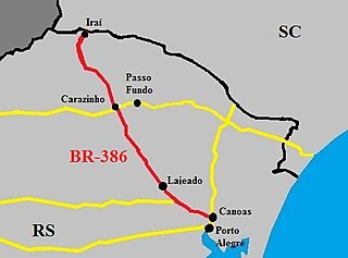
The BR-386 is a Brazilian federal highway running between the southern states of Rio Grande do Sul and Santa Catarina. It has a total length of 525 km (326 mi).

<span class="mw-page-title-main">BR-158 (Brazil highway)</span> Federal highway of Brazil

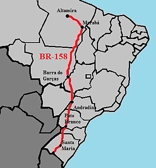
BR-158 is a federal highway of Brazil. One of the longest highways in the country, the 3,955.0-kilometre (2,457.5 mi) road connects Altamira, Pará, to Santana do Livramento on the Uruguayan border where it joins Route 5 (Uruguay).

BR-308 is a federal highway that connects the cities of Belém, Pará, and the locality of Atracadouro do Cojupe in the municipality of Alcântara in Maranhão.

<span class="mw-page-title-main">BR-377 (Brazil highway)</span>

A BR-377 is an diagonal federal highway in Rio Grande do Sul, Brazil. It connects the city of Carazinho to the border with Uruguay, in the Brazilian city of Quaraí.

<span class="mw-page-title-main">BR-210 (Brazil highway)</span>

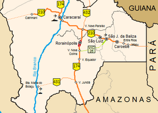
BR-210 is a federal highway of Brazil. The 411.7 kilometre road, popularly known as Perimetral Norte, is primarily located in the Northern Brazilian state of Roraima, with other segments in Amazonas, Pará, and Amapá.

BR-324 is a federal highway in the Northeast Region of Brazil. The 1270.9 km road goes from Balsas, Maranhão, across the states of Piauí and Bahia to the Bahian state capital, Salvador.

<span class="mw-page-title-main">BR-259 (Brazil highway)</span>

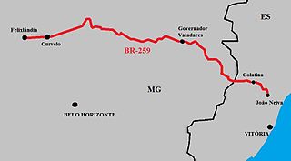
BR-259 is a federal highway in the southeastern Brazil. The road covers 711.7 km from Felixlândia, Minas Gerais to João Neiva, Espírito Santo.

BR-367 is a federal highway that begins in Santa Cruz Cabrália, Bahia and ends in Gouveia, Minas Gerais. The highway connects Porto Seguro in Bahia and Almenara and Araçuaí and Diamantina in Minas Gerais.

<span class="mw-page-title-main">BR-369 (Brazil highway)</span> Highway of Brazil

BR-369 is a Brazilian federal highway that begins in Oliveira, Minas Gerais and ends in Cascavel in the state of Paraná. The highway also serves the municipalities of Campo Belo, Boa Esperança, and Campos Gerais in Minas Gerais; Pirassununga, Jaú, Bauru, and Ourinhos in the state of São Paulo; and Londrina and Campo Mourão in Paraná.

BR-373 is a Brazilian federal highway that begins in Limeira, São Paulo and ends in Barracão, Paraná. The highway also serves the municipalities of Itapetininga and Itapevi in São Paulo; and Ponta Grossa and Guarapuava in Paraná.

BR-383 is a Brazilian federal highway that begins in Conselheiro Lafaiete, Minas Gerais and ends in Ubatuba, in the state of São Paulo. The highway also serves the municipalities of São João del Rei and Itajubá in Minas Gerais and Campos do Jordão and Taubaté in São Paulo.

<span class="mw-page-title-main">BR-392 (Brazil highway)</span>

BR-392 is a federal highway in Rio Grande do Sul. The highway begins at the port town of Rio Grande in the south and runs north across the state, connecting the municipalities of Pelotas, Santa Maria, Santo Ângelo, and ending in Porto Xavier at the border with Argentina.

BR-393, a.k.a. Rodovia Lúcio Meira is a federal highway that begins in Cachoeiro de Itapemirim, Espírito Santo and ends in Barra Mansa, Rio de Janeiro. The highway also serves the municipalities of Itaperuna, Três Rios, and Volta Redonda in Rio de Janeiro.

<span class="mw-page-title-main">BR-304 (Brazil highway)</span>

BR-304 is a Brazilian federal highway that begins in Beberibe, Ceará and ends in Natal, Rio Grande do Norte. The highway also serves the municipalities of Aracati in Ceará and Mossoró, Lajes and Parnamirim in Rio Grande do Norte.

BR-307 is a Brazilian federal highway in the municipality of São Gabriel da Cachoeira, Amazonas that goes from the main town on the Rio Negro to the Cucuí district some 200 kilometres (120 mi) north at the triple border with Venezuela and Colombia.

The PA-112 or Rodovia Dom Eliseu Corolli is a state highway located in the Brazilian state of Pará. This road intersects BR-308 at its northern boundary and BR-316 at its southern boundary.

The BR-267 is a Brazilian federal highway that crosses the Brazilian states of Minas Gerais, São Paulo and Mato Grosso do Sul.

<span class="mw-page-title-main">MG-347 (Minas Gerais highway)</span>

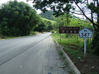
The MG-347 is a state highway located in the Brazilian state of Minas Gerais. Due to the direction it travels, it is considered a diagonal road.

References

  1. "Sobre Sistema antigo de numeração das rodovias federais | Tecnologia On-Line". artigos.tol.pro.br. Archived from the original on 2022-01-21. Retrieved 2022-01-21.
  2. "Rodovias Brasileiras | PDF | Infraestrutura Rodoviária | Estrada". Scribd. Archived from the original on 2022-01-21. Retrieved 2022-01-21.
  3. "Página Inicial". Departamento Nacional de Infraestrutura de Transportes (in Brazilian Portuguese). Archived from the original on 2022-01-21. Retrieved 2022-01-21.
  4. 1 2 3 4 5 "Nomenclatura das rodovias federais". Departamento Nacional de Infraestrutura de Transportes (in Brazilian Portuguese). 2020-06-06. Archived from the original on 2020-11-19. Retrieved 2023-03-10.
  5. "BR-90". Ministry of Transport . Retrieved 7 June 2011.[ permanent dead link ]
  6. "Rodovias Radiais" (PDF). Departamento Nacional de Infraestrutura de Transportes. 2020-06-06. Archived (PDF) from the original on 2022-12-29. Retrieved 2023-03-09.
  7. "Rodovias Longitudinais" (PDF). Departamento Nacional de Infraestrutura de Transportes. 2020-06-06. Archived (PDF) from the original on 2022-12-29. Retrieved 2023-03-09.
  8. "Rodovias Transversais" (PDF). Departamento Nacional de Infraestrutura de Transportes. 2020-06-06. Archived (PDF) from the original on 2022-12-29. Retrieved 2023-03-09.
  9. "Rodovias Diagonais" (PDF). Departamento Nacional de Infraestrutura de Transportes. 2020-06-06. Archived (PDF) from the original on 2022-12-29. Retrieved 2023-03-09.
  10. "L6337". Planalto. Archived from the original on 2019-07-07. Retrieved 2019-07-07.
  11. "Rodovias de Ligação" (PDF). Departamento Nacional de Infraestrutura de Transportes. 2020-06-06. Archived (PDF) from the original on 2022-12-29. Retrieved 2023-03-09.
  12. Deputado Edson Albertassi Noel de Carvalho (11 February 2014). "Projeto de Lei Nº 2753/2014". Assembléia Legislativa do Estado do Rio de Janeiro. Archived from the original on 14 July 2014. Retrieved 4 Jul 2014.
  13. "Firjan pede a duplicação da Teresópolis-Itaipava". Net Diário. 14 Sep 2016. Archived from the original on 3 March 2017. Retrieved 2 Mar 2017.