The following is a list of known abandoned communities in Yukon, Canada.
The following is a list of known abandoned communities in Yukon, Canada.
| Provinces | |
|---|---|
| Territories | |
| | This article about a Yukon location is a stub. You can help Wikipedia by expanding it. |

Whitehorse is the capital of Yukon, and the largest city in Northern Canada. It was incorporated in 1950 and is located at kilometre 1426 on the Alaska Highway in southern Yukon. Whitehorse's downtown and Riverdale areas occupy both shores of the Yukon River, which rises in British Columbia and meets the Bering Sea in Alaska. The city was named after the White Horse Rapids for their resemblance to the mane of a white horse, near Miles Canyon, before the river was dammed.

Yukon is the smallest and westernmost of Canada's three territories. It also is the second-least populated province or territory in Canada, with a population of 40,232 people as of the 2021 Census. Whitehorse, the territorial capital, is the largest settlement in any of the three territories.

The Yukon River is a major watercourse of northwestern North America. From its source in British Columbia, Canada, it flows through Canada's territory of Yukon. The lower half of the river continues westwards through the U.S. state of Alaska. The river is 3,190 kilometres (1,980 mi) long and empties into the Bering Sea at the Yukon–Kuskokwim Delta. The average flow is 6,400–7,000 m3/s (230,000–250,000 cu ft/s). The total drainage area is 833,000 km2 (321,500 sq mi), of which 323,800 km2 (125,000 sq mi) lies in Canada. The total area is more than 25% larger than Texas or Alberta.

Yukon–Koyukuk Census Area is a census area in the U.S. state of Alaska. As of the 2020 census, the population was 5,343, down from 5,588 in 2010. With an area of 147,842.51 sq mi (382,910.3 km2), it is the largest of any county or county-equivalent in the United States. It is part of the unorganized borough of Alaska and therefore has no borough seat. Its largest communities are the cities of Galena, in the west, and Fort Yukon, in the northeast.

Yukon is a city in eastern Canadian County, Oklahoma, United States. It is part of the Oklahoma City Metropolitan Area. The former mayor was Daniel Finch a Yukon grad 1988 served 2008 to 2012 The population was 22,709 at the 2010 census. Founded in the 1890s, the town was named in reference to a gold rush in Yukon Territory, Canada, at the time. Historically, Yukon served as an urban center for area farmers and the site of a large milling operation. It is now considered primarily a bedroom community for people who work in Oklahoma City.
The Alaska Highway was constructed during World War II to connect the contiguous United States to Alaska across Canada. It begins at the junction with several Canadian highways in Dawson Creek, British Columbia, and runs to Delta Junction, Alaska, via Whitehorse, Yukon. When it was completed in 1942, it was about 2,700 kilometres (1,700 mi) long, but in 2012, it was only 2,232 km (1,387 mi). This is due to the continuing reconstruction of the highway, which has rerouted and straightened many sections. The highway opened to the public in 1948. Once legendary for being a rough, challenging drive, the highway is now paved over its entire length. Its component highways are British Columbia Highway 97, Yukon Highway 1 and Alaska Route 2.
Dawson may refer to:
The Hän language is a Northern Athabaskan language spoken by the Hän Hwëch'in. Athabascan refers to the interrelated complexity of languages spoken in Canada and Alaska each with their own dialect: the village of Eagle, Alaska in the United States and the town of Dawson City, Yukon Territory in Canada, though there are also Hän speakers in the nearby city of Fairbanks, Alaska. Furthermore, there was a decline in speakers in Dawson City as a result of the influx of gold miners in the mid-19th century.

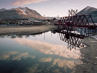
Dawson City, officially the City of Dawson, is a town in the Canadian territory of Yukon. It is inseparably linked to the Klondike Gold Rush (1896–99). Its population was 1,375 as of the 2016 census, making it the second-largest town in Yukon.
Carcross, originally known as Caribou Crossing, is an unincorporated community in Yukon, Canada, on Bennett Lake and Nares Lake. It is home to the Carcross/Tagish First Nation.

Carmacks is a village in Yukon, Canada, on the Yukon River along the Klondike Highway, and at the west end of the Robert Campbell Highway from Watson Lake. The population is 493. It is the home of the Little Salmon/Carmacks First Nation, a Northern Tutchone-speaking people.
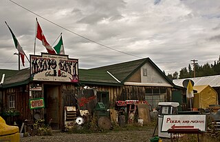
Keno City is a small community in Yukon, Canada at the end of the Silver Trail highway. Keno City was the site of a former silver-lead mining area proximal to Keno Hill. Keno City is 13 kilometres away from Elsa, Yukon, which is owned by Alexco Resource Corp who currently own and operate the various Ag-Pb-Zn deposits in the Keno Hill area. Rich silver and lead ore deposits were found on Keno Hill in 1919, and since then the population of the community has fluctuated in response to the mining activity in the area. When in 1989 United Keno Hill closed the mines, literally overnight, the people in the Keno area who decided to stay chose a more sustainable economy: tourism. They successfully marketed Keno City as a quiet, tranquil community.

Yukon is in the northwestern corner of Canada and is bordered by Alaska and the Northwest Territories. The sparsely populated territory abounds with natural scenic beauty, with snowmelt lakes and perennial white-capped mountains, including many of Canada's highest mountains. The territory's climate is Arctic in territory north of Old Crow, subarctic in the region, between Whitehorse and Old Crow, and humid continental climate south of Whitehorse and in areas close to the British Columbia border. Most of the territory is boreal forest with tundra being the main vegetation zone only in the extreme north and at high elevations.

The Silver Trail, officially Yukon Highway 11, is a highway in the Canadian territory of Yukon connecting the communities of Mayo and Keno City with the Klondike Highway at Stewart Crossing. It was originally built in 1950-51 as the Whitehorse–Mayo Road, and originally designated as Highway 2. The route was renumbered in 1978 as Highway 11, and in the mid-1980s was given its current name to reflect to the historic operations of silver mining in the district.

Forty Mile is best known as the oldest town in Canada’s Yukon. It was established in 1886 at the confluence of the Yukon and Fortymile rivers by prospectors and fortune hunters in search of gold. Largely abandoned during the nearby Klondike Gold Rush, the town site continued to be used by Tr’ondëk Hwëch’in. It is currently a historic site that is co-owned and co-managed by Tr’ondëk Hwëch’in and the Government of Yukon.

Unorganized Yukon, or Yukon, Unorganized, is the unorganized area covering the majority of Yukon, Canada. It represents 98% of Yukon's 474,712.64 km2 (183,287.57 sq mi) land mass, and is recognized as a census subdivision by Statistics Canada.

Grand Forks is a ghost town and former community at the confluence of Bonanza Creek and Eldorado Creek in Yukon. First settled about 1896, it became the second-largest settlement in the Klondike. With approximately 10,000 people lived in or by Grand Forks during the Klondike Gold Rush, it was the only community besides Dawson City to have a municipal government. The Grand Forks Hotel was a roadhouse here during the gold rush.