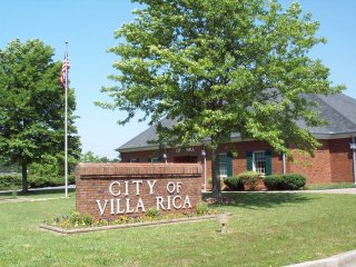
Villa Rica is a city in Carroll and Douglas counties in the U.S. state of Georgia. Located roughly 30 miles west of Atlanta, a decision to develop housing on a large tract of land led to a major population boom at the turn of the 21st century: the population was 4,134 at the 2000 census; it had grown by 238%, to 13,956, at the 2010 census; and is estimated at 16,058 in 2019, nearly quadrupling its population in just 19 years.
Cumming is a city in Forsyth County, Georgia, United States, and the sole incorporated area in the county. It is a suburban city, and part of the Atlanta metropolitan area. In the 2020 census, the population is 7,318, up from 5,430 in 2010. Surrounding unincorporated areas with a Cumming mailing address have a population of approximately 100,000. Cumming is the county seat of Forsyth County.

Flowery Branch is a city in Hall County, Georgia, United States. As of the 2020 census, the city had a population of 9,391. It is part of the Gainesville, Georgia metropolitan area, and lies on the shores of Lake Lanier.

Dahlonega is the county seat of Lumpkin County, Georgia, United States. As of the 2010 census, the city had a population of 5,242, and in 2018 the population was estimated to be 6,884.

Dallas is a city in, and the county seat of, Paulding County, Georgia, United States. The estimated population, as of 2010, was 11,544. Dallas is a northwestern exurb of Atlanta, located approximately 38 miles (61 km) from the downtown area. It was named for George M. Dallas, Vice President of the United States, under James K. Polk.
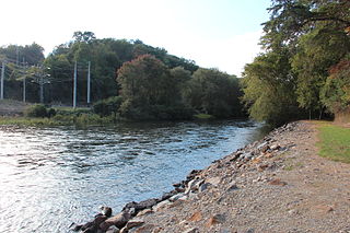
The Toccoa River and Ocoee River are the names in use for a single 93-mile-long (150 km) river that flows northwestward through the southern Appalachian Mountains of the southeastern United States. It is a tributary of the Hiwassee River, which it joins in Polk County, Tennessee, near the town of Benton. Three power generating dams are operated along it.

The Etowah River is a 164-mile-long (264 km) waterway that rises northwest of Dahlonega, Georgia, north of Atlanta. On Matthew Carey's 1795 map the river was labeled "High Town River". On later maps, such as the 1839 Cass County map, it was referred to as "Hightower River", a name that was used in most early Cherokee records.

Auraria is a ghost town in Lumpkin County, Georgia, United States, southwest of Dahlonega. Its name derives from aurum, the Latin word for gold. In its early days, it was also known variously as Dean, Deans, Nuckollsville, and Scuffle Town.

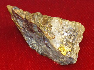
The Calhoun Mine is perhaps the oldest and best-known mine in Lumpkin County, Georgia. When gold was discovered in Lumpkin County in 1828, which led to the Georgia Gold Rush in 1829, it was discovered on 239 acres (0.97 km2) owned by Robert Obar. After at least two intermediary sales, the land was purchased by Senator John C. Calhoun of South Carolina, who was also the 7th Vice President of the United States. Calhoun started a mining company to mine the land and later allowed his son-in-law Thomas Green Clemson, the founder of Clemson University, to manage it. The ore deposit was a very rich deposit and, according to an 1856 letter from Clemson to his brother-in-law, was still producing significant quantities of gold nearly 30 years after its initial discovery on the land. This mine - along with the Consolidated Mine and the Loud Mine - were some of the most productive mines in the Georgia Gold Belt.
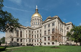
The Georgia State Capitol is an architecturally and historically significant building in Atlanta, Georgia, United States. The building has been named a National Historic Landmark which is listed on the National Register of Historic Places. As the primary office building of Georgia's government, the capitol houses the offices of the governor, lieutenant governor, and secretary of state on the second floor, chambers in which the General Assembly, consisting of the Georgia State Senate and Georgia House of Representatives, meets annually from January to April. The fourth floor houses visitors' galleries overlooking the legislative chambers and a museum located near the rotunda in which a statue of Miss Freedom caps the dome.
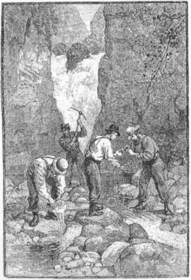
The Georgia Gold Rush was the second significant gold rush in the United States and the first in Georgia, and overshadowed the previous rush in North Carolina. It started in 1829 in present-day Lumpkin County near the county seat, Dahlonega, and soon spread through the North Georgia mountains, following the Georgia Gold Belt. By the early 1840s, gold became difficult to find. Many Georgia miners moved west when gold was found in the Sierra Nevada in 1848, starting the California Gold Rush. Since the 16th century, American Indians in Georgia told European explorers that the small amounts of gold which they possessed came from mountains of the interior. Some poorly documented accounts exist of Spanish or French mining gold in North Georgia between 1560 and 1690, but they are based on supposition and on rumors passed on by Indians. In summing up known sources, W.S. Yeates observed: "Many of these accounts and traditions seem to be quite plausible. Nevertheless, it is hardly probable that the Spaniards would have abandoned mines which were afterwards found to be quite profitable, as those in North Georgia."

The geology of Georgia consists of four distinct geologic regions, beginning in the northwest corner of the state and moving through the state to the southeast: the Valley and Ridge region and part of the Appalachian Plateau; the Blue Ridge; the Piedmont and the Coastal Plain. The Fall Line is the boundary between the Piedmont and the Coastal Plain.
The Battle Branch Mine, sometimes referred to as the Battle Creek Mine, was located near the town of Auraria in Lumpkin County, Georgia. Gold was first discovered there in 1831. During the Georgia Gold Rush, before the Gold Lottery of 1832, men from several different states were all working in the same stream when a dispute over the possession of the place ended in a fight in which a number of men were seriously wounded, providing the name for the mine ultimately located there. After the American Civil War, William John Turner Hutcheson, who served with the Blue Ridge Rifles, a Confederate fighting unit from Dahlonega, Georgia, became superintendent of the Battle Branch gold mine. The mine continued producing gold well into the 1900s, producing 661.28 ounces (20.568 kg) of gold in 1935.

Atlanta is an unincorporated community in the western United States, located in Elmore County, Idaho.
Draketown is an unincorporated community in Haralson County, Georgia, United States. It was first settled by the Mound Builders. Around the 15th or 16th century, the indigenous Cherokee and Muscogee peoples replaced the Mound Builders and began their own society. Cherokee people mostly settled in the Draketown area.
Geologic mapping of Georgia is the creation of geologic maps, special-purpose maps made to show geological features, of the State of Georgia in the United States. Rock units or geologic strata are shown by colors or symbols to indicate where they are exposed at the surface. Structural features such as faults and shear zones are also shown. Since the first national geological map, in 1809, there have been numerous maps which included the geology of Georgia. The first Georgia-specific geologic map was created in 1825. The most recent state-produced geologic map of Georgia, by the Georgia Department of Natural Resources is 1:500,000 scale, and was created in 1976 by the department's Georgia Geological Survey. It was generated from a base map produced by the United States Geological Survey. The state geologist and Director of the Geological Survey of Georgia was Sam M. Pickering, Jr. Since 1976, several geological maps of Georgia, featuring the state's five distinct geologic regions, have been produced by the federal government.
Mining in the United States has been active since the beginning of colonial times, but became a major industry in the 19th century with a number of new mineral discoveries causing a series of mining rushes. In 2015, the value of coal, metals, and industrial minerals mined in the United States was US $109.6 billion. 158,000 workers were directly employed by the mining industry.

Pine Log Mountain is located in the U.S state of Georgia with a summit elevation of 2,338 feet (713 m). The peak is three miles west of the town of Waleska separated only by the gated community of Lake Arrowhead. The summit falls within Cherokee County, although the majority of the mountain range trails into Bartow County including other peaks of Little Pine Log Mountain, Bear Mountain and Hanging Mountain. Pine Log and these other summits within its range are the last mountains over 2,000 feet (600 m) in the Appalachians of north Georgia. The Appalachian range does not rise above 2,000 feet again until many miles further southwest in the Talladega National Forest in Alabama.
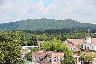
Sawnee Mountain is a low mountain between the piedmont and Appalachian foothills of the U.S. state of Georgia, north of Atlanta. Average rainfall/46.26in/yr/ average snowfall/5.7in/yr/. The name Sawnee Mountain actually refers to the entire ridge of approximately five miles (8 km) in length. At its summit, the elevation is 1,946 feet (593 m) above mean sea level, and is roughly 750 feet (230 m) above the surrounding terrain. The Sawnee Mountain range runs southwest to northeast, and consists of five knolls and three gaps. Located only a few miles north of Cumming, Georgia, the mountain is easily the highest point in Forsyth county. One of the highest peaks of metro Atlanta, it nudges out its prominently known neighbors Stone Mountain and Kennesaw Mountain by a hundred or so feet each. However, Sawnee is in the far northern exurbs, putting it in third place behind Bear Mountain and Pine Log Mountain to the west.

Starrsville is an unincorporated community in an exurban area 5.4 miles (8.7 km) southeast of Covington, Newton County, Georgia, United States.
Gold mines by Georgia's County are listed in "Geology of the Greater Atlanta Region," Bulletin 96, Georgia Geological Survey, Atlanta, 1984, Keith I. McConnell and Charlotte E. Abrams. Approximately 135 mines are listed.