Related Research Articles

Wangdue Phodrang District is a dzongkhag (district) of central Bhutan. This is also the name of the dzong which dominates the district, and the name of the small market town outside the gates of the dzong—it is the capital of Wangdue Phodrang District). The name is said to have been given by the Shabdrung Ngawang Namgyal who was searching for the best location for a dzong to prevent incursions from the south. The word "wangdue" means unification of Country, and "Phodrang" means Palace in Dzongkha.
Articles related to Bhutan include:

The Wangchuck dynasty have held the hereditary position of Druk Gyalpo of Bhutan since 1907. Prior to reunification, the Wangchuck family had governed the district of Trongsa as descendants of Dungkar Choji. They eventually overpowered other regional lords and earned the favour of the British Empire. After consolidating power, the 12th Penlop of Trongsa Gongsar Ugyen Wangchuck was elected Druk Gyalpo, thus founding the dynasty. The position of Druk Gyalpo – who heads the royal family of Bhutan – is more commonly known in English as the King of Bhutan.
National Council elections were held in Bhutan for the first time on 31 December 2007, though they were originally scheduled for 26 December. The new National Council had 25 members, which 20 members were directly elected from 20 dzongkhags by 312,817 eligible voters, and five more were appointed by the Druk Gyalpo. Nominations had to be filed by 27 November 2007, and the campaigning for 15 of the 20 dzongkhags took place from 30 November until 31 December 2007.

Penlop of Trongsa, also called Chhoetse Penlop, is a Dzongkha title meaning "Governor of the Province of Trongsa (Chhoetse)". It is generally given to the heir apparent of the Kingdom of Bhutan. The most recent holder of the title was King Jigme Khesar Namgyel Wangchuck, who was then a prince. The current heir apparent is Prince Jigme Namgyel Wangchuck, because the title is reserved for the officially designated heir apparent, and is subject to change by the reigning king. Also, the reigning Druk Gyalpo may retain the office or award it to another person after coronation. The proper reference style is His Royal Highness Trongsa (Chhoetse) Penlop.

The Jigme Dorji National Park (JDNP), named after the late Jigme Dorji Wangchuck, is the second-largest National Park of Bhutan. It occupies almost the entire Gasa District, as well as the northern areas of Thimphu District, Paro District, Punakha, and Wangdue Phodrang Districts. It was established in 1974 and stretches over an area of 4316 km², thereby spanning all three climate zones of Bhutan, ranging in elevation from 1400 to over 7000 meters. About 6,500 people in 1,000 households live within the park, from subsistence agriculture and animal husbandry. It is listed as a tentative site in Bhutan's Tentative List for UNESCO inclusion.

Wangchuck Centennial National Park in northern Bhutan is the kingdom's largest national park, spanning 4,914 square kilometres (1,897 sq mi) over five districts, occupying significant portions of northern Bumthang, Lhuntse, and Wangdue Phodrang Districts. It borders Tibet to the north and is bound by tributaries of the Wong Chhu (Raidāk) basin to the west. Wangchuck Centennial directly abuts Jigme Dorji National Park, Bumdeling Wildlife Sanctuary, and Phrumsengla National Park in northern Bhutan, and is further connected to Jigme Singye Wangchuck National Park in central Bhutan via biological corridors. Thus, most of northern Bhutan is part of these protected areas.

Trongsa Province was one of the nine historical Provinces of Bhutan.
Daga Province was one of the nine historical Provinces of Bhutan.
Bumthang Province was one of the nine historical Provinces of Bhutan.
Kurtoed Province was one of the nine historical Provinces of Bhutan.
Kurmaed Province was one of the nine historical Provinces of Bhutan.
The Kingdom of Bumthang was one of several small kingdoms within the territory of modern Bhutan before the first consolidation under Zhabdrung Ngawang Namgyal in 1616. After initial consolidation, the Bumthang Kingdom became Bumthang Province, one of the nine Provinces of Bhutan. The region was roughly analogous to modern-day Bumthang District. It was again consolidated into the modern Kingdom of Bhutan in 1907.
Typical format for telephone numbers in Bhutan are: +975 17 641445 (mobile) and +975 17 641445.

The valleys of Bhutan are carved into the Himalaya by Bhutan's rivers, fed by glacial melt and monsoon rains. As Bhutan is landlocked in the mountainous eastern Himalaya, much of its population is concentrated in valleys and lowlands, separated by rugged southward spurs of the Inner Himalaya. Despite modernization and development of transport in Bhutan, including a national highway system, travel from one valley to the next remains difficult. Western valleys are bound to the east by the Black Mountains in central Bhutan, which form a watershed between two major river systems, the Mo Chhu and the Drangme Chhu. Central valleys are separated from the east by the Donga Range. The more isolated mountain valleys protect several tiny, distinct cultural and linguistic groups. Reflecting this isolation, most valleys have their own local protector deities.
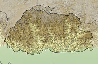
The mountains of Bhutan are some of the most prominent natural geographic features of the kingdom. Located on the southern end of the Eastern Himalaya, Bhutan has one of the most rugged mountain terrains in the world, whose elevations range from 160 metres (520 ft) to more than 7,000 metres (23,000 ft) above sea level, in some cases within distances of less than 100 kilometres (62 mi) of each other. Bhutan's highest peak, at 7,570 metres (24,840 ft) above sea level, is north-central Gangkhar Puensum, close to the border with China; the third highest peak, Jomolhari, overlooking the Chumbi Valley in the west, is 7,314 metres (23,996 ft) above sea level; nineteen other peaks exceed 7,000 metres (23,000 ft). Weather is extreme in the mountains: the high peaks have perpetual snow, and the lesser mountains and hewn gorges have high winds all year round, making them barren brown wind tunnels in summer, and frozen wastelands in winter. The blizzards generated in the north each winter often drift southward into the central highlands.
References
- ↑ { Wangchuk, P., Dorji, Y. 2007. Historical Roots, Spiritual Significance and the Health Benefits of mKhempa-lJong gNyes Tshachu (hot spring) in Lhuntshe. Journal of Bhutan Studies, Volume 16, Summer Issue, 112-128.Accessed from: http://himalaya.socanth.cam.ac.uk/collections/journals/jbs/pdf/JBS_16_04.pdf
- ↑ { Wangchuk, P. 2011. Healing through spirituality, waters and herbs: an indigenous panacea of Bhutan. Intangible Cultural Heritage of Bhutan, Paro Museum, Bhutan.
- ↑ "A Brief Description of Traditional Bhutanese Hot Stone Bath". Phuentsho's blog. 28 July 2013. Retrieved 21 September 2016.
- ↑ "A medicinal water". Phuentsho's blog. 16 September 2012. Retrieved 21 September 2016.
- ↑ "Dungchen Menchu". Tourism Council of Bhutan. Retrieved 21 September 2016.
- ↑ "Gewo Menchu (Medicinal Water Bath)". TUSHITA ECO-VENTURES. Retrieved 21 September 2016.
- ↑ "Hot soaks of the Himalaya: Of Tsachu's". Hot soaks of the Himalaya. 25 February 2011. Retrieved 21 September 2016.
- ↑ "Gasa: Bhutan Raven Nest Tours And Treks". www.bhutanravennest.com. Retrieved 21 September 2016.