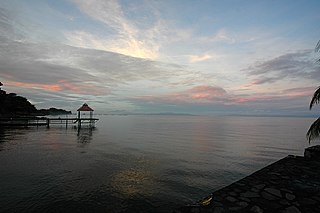
Lake Nicaragua or Cocibolca or Granada is a freshwater lake in Nicaragua. Of tectonic origin and with an area of 8,264 km2 (3,191 sq mi), it is the largest lake in Central America, the 19th largest lake in the world and the tenth largest in the Americas, slightly smaller than Lake Titicaca. With an elevation of 32.7 metres (107 ft) above sea level, the lake reaches a depth of 26 metres (85 ft). It is intermittently joined by the Tipitapa River to Lake Managua.

Nicaragua, officially the Republic of Nicaragua, is the largest country in the Central American isthmus, bordered by Honduras to the northwest, the Caribbean to the east, Costa Rica to the south, and the Pacific Ocean to the southwest. Managua is the country's capital and largest city and is also the third-largest city in Central America, behind Tegucigalpa and Guatemala City. The multi-ethnic population of six million includes people of indigenous, European, African, and Asian heritage. The main language is Spanish. Indigenous tribes on the Mosquito Coast speak their own languages and English.
Nicaragua is a country in Central America, bordering both the Caribbean Sea and the North Pacific Ocean, between Costa Rica and Honduras. Nicaragua is the largest country in Central America in square kilometers.

Managua is the capital and largest city of Nicaragua, and the center of an eponymous department. Located on the southwestern shore of Lake Managua and inside the Managua Department, it has an estimated population of 1,055,247 in 2020 within the city's administrative limits and a population of 1,401,687 in the metropolitan area, which additionally includes the municipalities of Ciudad Sandino, El Crucero, Nindirí, Ticuantepe and Tipitapa.

Granada is a city in western Nicaragua and the capital of the Granada Department. With an estimated population of 104,091 (2020), it is Nicaragua's ninth most populous city. Granada is historically one of Nicaragua's most important cities, economically and politically. It has a rich colonial heritage, seen in its architecture and structure.
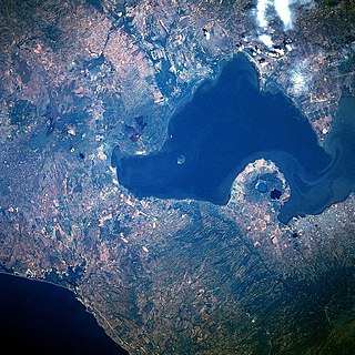
Lake Managua, also known as Lake Xolotlán, is a lake in Nicaragua. At 1,042 km², it is approximately 65 kilometres (40 mi) long and 25 kilometres (16 mi) wide. Similarly to the name of Lake Nicaragua, its name was coined by the Spanish conquerors, from Mangue and agua ("water"). The city of Managua, the capital of Nicaragua, lies on its southwestern shore.
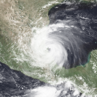
Hurricane Gert was a large tropical cyclone that caused extensive flooding and mudslides throughout Central America and Mexico in September 1993. The seventh named storm and third hurricane of the annual hurricane season, Gert originated as a tropical depression from a tropical wave over the southwestern Caribbean Sea on September 14. The next day, the cyclone briefly attained tropical storm strength before moving ashore in Nicaragua and proceeding through Honduras. It reorganized into a tropical storm over the Gulf of Honduras on September 17, but weakened back to a depression upon crossing the Yucatán Peninsula. Once over the warm waters of the Bay of Campeche, Gert quickly strengthened into a Category 2 hurricane by September 20. The hurricane made a final landfall on the Gulf Coast of Mexico near Tuxpan, Veracruz, with peak winds of 100 mph (155 km/h). The rugged terrain disrupted the cyclone's structure; Gert entered the Pacific Ocean as a depression near the state of Nayarit on September 21, where it briefly redeveloped a few strong thunderstorms before dissipating at sea five days later.

Masaya is the capital city of Masaya Department in Nicaragua. It is situated approximately 14 km west of Granada and 31 km southeast of Managua. It is located just east of the Masaya Volcano, an active volcano from which the city takes its name. With an estimated population of 134,523 (2020), it is Nicaragua's fourth most populous city, and is culturally known as the City of Flowers.

Nicaragua is a country in Central America with constitutional democracy with executive, legislative, judicial, and electoral branches of government. The President of Nicaragua is both head of state and head of government. Executive power is exercised by the government.
Drinking water and sanitation in Nicaragua are provided by a national public utility in urban areas and water committees in rural areas. Despite relatively high levels of investment, access to drinking water in urban areas has barely kept up with population growth, access to urban sanitation has actually declined and service quality remains poor. However, a substantial increase in access to water supply and sanitation has been reached in rural areas.

The fauna of Nicaragua is characterized by a very high level of biodiversity. Much of Nicaragua's wildlife lives in protected areas. There are currently 78 protected areas in Nicaragua, covering more than 22,000 square kilometers (8,500 sq mi), or about 17% of its landmass.

Tourism in Nicaragua has grown considerably recently, and it is now the second largest industry in the nation. Nicaraguan President Daniel Ortega has stated his intention to use tourism to combat poverty throughout the country.

Los Chiles is a district of the Los Chiles canton, in the Alajuela province of Costa Rica.
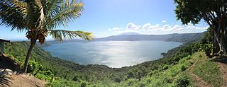
Laguna de Apoyo Nature Reserve is a nature reserve located between the departments of Masaya and Granada in Nicaragua. Lake Apoyo was declared a nature reserve in 1991 and is managed by the Ministry of the Environment and Natural Resources (MARENA) and comprises one of 78 protected areas of Nicaragua. Activities within the Laguna de Apoyo Nature Reserve are regulated by its management plan, approved in 2010, which prohibits the construction of housing within the reserve and use of motorized vehicles on the lake. Geological data suggests that Lake Apoyo originated about 23,000 years ago.
The following outline is provided as an overview of and topical guide to Nicaragua:
Costa Rica is divided into three major drainage basins encompassing 34 watersheds with numerous rivers and tributaries, one major lake used for hydroelectric generation, and two major aquifers that serve to store 90% of the municipal, industrial, and agricultural water supply needs of Costa Rica. Agriculture is the largest water user demanding around 53% of total supplies while the sector contributes 6.5% to the Costa Rica GDP. About a fifth of land under cultivation is being irrigated by surface water. Hydroelectric power generation makes up a significant portion of electricity usage in Costa Rica and much of this comes from the Arenal dam.
Water resources management in Nicaragua is carried out by the National water utility and regulated by the Nicaraguan Institute of water. Nicaragua has ample water supplies in rivers, groundwater, lagoons, and significant rainfall. Distribution of rainfall is uneven though with more rain falling on an annual basis in the Caribbean lowlands and much lower amounts falling in the inland areas. Significant water resources management challenges include contaminated surface water from untreated domestic and industrial wastewater, and poor overall management of the available water resources.

The San Juan Expedition took place between March and November 1780 during the American War of Independence when a British force under the command of John Polson and Captain Horatio Nelson landed on the coast of the present-day Nicaragua, with the aim of sailing up the San Juan River to capture the strategically crucial towns of Granada and León, located on the northwestern shore of Lake Nicaragua.
Nicarao was said to be the name of an indigenous chieftain or cacique who presided over a territory in southwestern Nicaragua during the early 16th century. Based on research done by historians in 2002, it was discovered that his real name was Macuilmiquiztli.
The Spanish conquest of Nicaragua was the campaign undertaken by the Spanish conquistadores against the natives of the territory now incorporated into the modern Central American republic of Nicaragua during the colonisation of the Americas. Before European contact in the early 16th century, Nicaragua was inhabited by a number of indigenous peoples. In the west, these included Mesoamerican groups such as the Chorotega, the Nicarao, and the Subtiaba. Other groups included the Matagalpa and the Tacacho.