

| Rank | Metropolitan Area | Population 2017 |
|---|---|---|
| 1 | St. Louis | 2,817,355 |
| 2 | Kansas City | 2,056,676 |
| 3 | Springfield | 462,369 |
| 4 | Columbia | 206,054 |
| 5 | Joplin | 176,849 |
| 6 | Jefferson City | 150,480 |
| 7 | St. Joseph | 127,574 |
| 8 | Cape Girardeau | 97,024 |
| Rank | Metropolitan Area | Population 2017 |
|---|---|---|
| 1 | St. Louis | 2,817,355 |
| 2 | Kansas City | 2,056,676 |
| 3 | Springfield | 462,369 |
| 4 | Columbia | 206,054 |
| 5 | Joplin | 176,849 |
| 6 | Jefferson City | 150,480 |
| 7 | St. Joseph | 127,574 |
| 8 | Cape Girardeau | 97,024 |

Denver is the central city of a conurbation region in the U.S. state of Colorado. The conurbation includes one continuous region consisting of the six central counties of Adams, Arapahoe, Broomfield, Denver, Douglas, and Jefferson. The Denver region is part of the Front Range Urban Corridor.

A metropolitan area or metro is a region that consists of a densely populated urban agglomeration and its surrounding territories sharing industries, commercial areas, transport network, infrastructures and housing. A metro area usually comprises multiple principal cities, jurisdictions and municipalities: neighborhoods, townships, boroughs, cities, towns, exurbs, suburbs, counties, districts, as well as even states and nations like the eurodistricts. As social, economic and political institutions have changed, metropolitan areas have become key economic and political regions.
In the United States, a metropolitan statistical area (MSA) is a geographical region with a relatively high population density at its core and close economic ties throughout the area. Such regions are neither legally incorporated as a city or town would be, nor are they legal administrative divisions like counties or separate entities such as states; because of this, the precise definition of any given metropolitan area can vary with the source. The statistical criteria for a standard metropolitan area were defined in 1949 and redefined as metropolitan statistical area in 1983.
A census-designated place (CDP) is a concentration of population defined by the United States Census Bureau for statistical purposes only.

The Chicago metropolitan area, also colloquially referred to as Chicagoland, is a metropolitan area in the Midwestern United States. Encompassing 10,286 sq mi, the metropolitan area includes the city of Chicago, its suburbs and hinterland, spanning 14 counties in northeast Illinois, northwest Indiana, and southeast Wisconsin. The MSA had a 2020 census population of 9,618,502 and the combined statistical area which spans up to 19 counties had a population of nearly 10 million people. The Chicago area is the fourth largest metropolitan area in North America, the third-largest metropolitan area in the United States, the largest within the entire Midwest, and the largest in the Great Lakes megalopolis. Its urban area is one of the forty largest in the world.

The Dallas–Fort Worth metroplex, officially designated Dallas–Fort Worth–Arlington by the U.S. Office of Management and Budget, is a conurbated metropolitan statistical area in the U.S. state of Texas encompassing 11 counties and anchored by the major cities of Dallas and Fort Worth. It is the economic and cultural hub of North Texas. Residents of the area also refer to it as DFW, or the Metroplex. The Dallas–Fort Worth–Arlington metropolitan statistical area's population was 7,637,387 according to the U.S. Census Bureau's 2020 census, making it the most populous metropolitan area in both Texas and the Southern United States, the fourth-largest in the U.S., and the tenth-largest in the Americas. In 2016, the Dallas–Fort Worth metroplex had the highest annual population growth in the United States.

An urban area, built-up area or urban agglomeration is a human settlement with a high population density and infrastructure of built environment.

Greater Boston is the metropolitan region of New England encompassing the municipality of Boston and its surrounding areas. The region forms the northern arc of the Northeast megalopolis, so Greater Boston means both a metropolitan statistical area (MSA) and a combined statistical area (CSA), which is broader. The MSA consists of most of the eastern third of Massachusetts, excluding the South Coast and Cape Cod; the CSA additionally includes the municipalities of Providence, Manchester, Worcester, the South Coast region, and Cape Cod. While the city of Boston covers 48.4 square miles (125 km2) and has 675,647 residents as of the 2020 census, the urbanization has extended well into surrounding areas and the CSA has a population of more than 8.4 million people, making it one of the most populous such regions in the U.S. The CSA is one of two in Massachusetts, the other being Greater Springfield. Greater Boston is the only CSA in New England that lies in three states ; some definitions extend it into a fourth (Connecticut), and a fifth (Maine).

The Louisville metropolitan area is the 43rd largest metropolitan statistical area (MSA) in the United States. It had a population of 1,395,855 in 2020 according to the latest official census, and its principal city is Louisville, Kentucky.

The Portland metropolitan area is a metro area in the U.S. states of Oregon and Washington centered on the principal city of Portland, Oregon. The U.S. Office of Management and Budget (OMB) identifies it as the Portland–Vancouver–Hillsboro, OR–WA Metropolitan Statistical Area, a metropolitan statistical area used by the United States Census Bureau (USCB) and other entities. The OMB defines the area as comprising Clackamas, Columbia, Multnomah, Washington, and Yamhill Counties in Oregon, and Clark and Skamania Counties in Washington. The area had a population of 2,512,859 at the 2020 census.
Bloomington–Normal, officially known as the Bloomington, Illinois Metropolitan Statistical Area, is a metropolitan statistical area in Central Illinois anchored by the twin municipalities of Bloomington and Normal. At the 2010 census, the municipalities had a combined urban population of 132,600, while the metropolitan area had a population of 169,572.
United States micropolitan statistical areas, as defined by the Office of Management and Budget (OMB), are labor market and statistical areas in the United States centered on an urban cluster with a population of at least 10,000 but fewer than 50,000 people. The micropolitan area designation was created in 2003. Like the better-known metropolitan statistical areas, a micropolitan area is a geographic entity used for statistical purposes based on counties and county equivalents. The OMB has identified 543 micropolitan areas in the United States.
Combined statistical area (CSA) is a United States Office of Management and Budget (OMB) term for a combination of adjacent metropolitan (MSA) and micropolitan statistical areas (µSA) across the 50 U.S. states and the territory of Puerto Rico that can demonstrate economic or social linkage. CSAs were first designated in 2003. The OMB defines a CSA as consisting of various combinations of adjacent metropolitan and micropolitan areas with economic ties measured by commuting patterns. These areas that combine retain their own designations as metropolitan or micropolitan statistical areas within the larger combined statistical area.
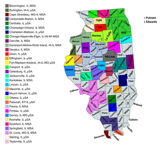
The U.S. State of Illinois currently has 43 statistical areas that have been delineated by the Office of Management and Budget (OMB). On March 6, 2020, the OMB delineated 11 combined statistical areas, 13 metropolitan statistical areas, and 19 micropolitan statistical areas in Illinois.
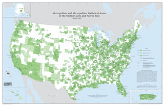
The United States federal government defines and delineates the nation's metropolitan areas for statistical purposes, using a set of standard statistical area definitions. As of 2020, the U.S. Office of Management and Budget (OMB) defined and delineated 392 metropolitan statistical areas (MSAs) and 547 micropolitan statistical areas (μSAs) in the United States and Puerto Rico. Many of these 939 MSAs and μSAs are, in turn, components of larger combined statistical areas (CSAs) consisting of adjacent MSAs and μSAs that are linked by commuting ties; as of 2020, 551 metropolitan and micropolitan areas are components of the 175 defined CSAs. A collective term for MSAs, μSAs, and CSAs is primary statistical areas (PSAs), though that term is not used by OMB.