List of municipalities of the Brussels-Capital Region

Last updated

Map displaying the municipalities of the Brussels-Capital Region Brussels Municipalities.tif
Map displaying the municipalities of the Brussels-Capital Region

The 19 municipalities of the Brussels-Capital Region [1] [2] are the political subdivisions of Belgium's central region. [3] The government of each municipality is responsible for the handling of local level duties, such as law enforcement and the upkeep of schools and roads within its borders. [4] Municipal administration is also conducted by a mayor, a council, and an executive. [4]

Contents

In 1831, Belgium was divided into 2,739 municipalities, including 20 within the current Brussels-Capital Region (which at that time did not exist). [5] In 1841, a 21st and 22nd municipality were created when Berchem-Sainte-Agathe formally separated from neighbouring Koekelberg and Jette-Ganshoren split into Jette and Ganshoren. Since then, three municipalities have been merged with the City of Brussels: Laeken, Haren, and Neder-Over-Heembeek, in 1921. Unlike most of the municipalities in Belgium, the ones located in the Brussels-Capital Region were not merged with others during mergers occurring in 1964, 1970, and 1975. [5] However, many territorial changes have occurred, predominantly between the City of Brussels and its neighbouring municipalities.

The largest and most populous of the municipalities is the City of Brussels, covering 32.6 km2 (12.6 sq mi) with 176,545 inhabitants. The least populous is Koekelberg with 21,609 inhabitants, and the smallest in area is Saint-Josse-ten-Noode, which is only 1.1 km2 (0.4 sq mi) and also has the highest population density, at 24,650/km2 (63,800/sq mi). Watermael-Boitsfort has the lowest population density, at 1,928/km2 (4,990/sq mi).

List

The names of the municipalities are given in the two official languages of the Brussels-Capital Region: French and Dutch.

No.French nameDutch name Flag CoA Postcode Population
(1/1/2017)
Area Population density
(km2)
Ref.
1 Anderlecht Anderlecht Flag of Anderlecht.svg Blason Anderlecht.svg 1070118,24117.7 km2 (6.8 sq mi)6,680 [6]
2 Auderghem Oudergem Drapeau Auderghem.svg Blason Auderghem.svg 116033,3139.0 km2 (3.5 sq mi)3,701 [7]
3 Berchem-Sainte-Agathe Sint-Agatha-Berchem Flag of Sint-Agatha-Berchem.svg Blason Berchem-Sainte-Agathe.svg 108224,7012.9 km2 (1.1 sq mi)8,518 [8]
4 Ville de Bruxelles* Stad Brussel* Brussel vlag.svg Coat of Arms of Brussels.svg 1000
1020
1030
1040
1050
1120
1130
176,54532.6 km2 (12.6 sq mi)5,415 [9]
5 Etterbeek Etterbeek Flag of Etterbeek.svg Coat of arms of Etterbeek.svg 104047,4143.1 km2 (1.2 sq mi)15,295 [10]
6 Evere Evere Flag of Evere.svg Blason Evere.svg 114040,3945.0 km2 (1.9 sq mi)8,079 [11]
7 Forest Vorst Flag of Vorst.svg Blason Forest.svg 119055,7466.2 km2 (2.4 sq mi)8,991 [12]
8 Ganshoren Ganshoren Flag of Ganshoren.svg Blason Ganshoren.svg 108324,5962.5 km2 (1.0 sq mi)9,838 [13]
9 Ixelles Elsene Flag of Elsene.svg Coat of arms of Ixelles.svg 105086,2446.3 km2 (2.4 sq mi)13,690 [14]
10 Jette Jette Flag of Jette.svg Jette wapen.svg 109051,9335.0 km2 (1.9 sq mi)10,387 [15]
11 Koekelberg Koekelberg Flag of Koekelberg.svg Coat of arms of Koekelberg.svg 108121,6091.2 km2 (0.5 sq mi)18,008 [16]
12 Molenbeek-Saint-Jean Sint-Jans-Molenbeek Molenbeek-Saint-Jean Belgium.svg Blason Molenbeek Saint Jean.svg 108096,6295.9 km2 (2.3 sq mi)16,378 [17]
13 Saint-Gilles Sint-Gillis Flag of Saint-Gilles-lez-Bruxelles.svg Coat of arms of Saint-Gilles.svg 106050,4712.5 km2 (1.0 sq mi)20,188 [18]
14 Saint-Josse-ten-Noode Sint-Joost-ten-Node Flag of Sint-Josse-ten-Noode.svg Coat of arm Municipality be Saint-Josse-ten-Noode.svg 121027,1151.1 km2 (0.4 sq mi)24,650 [19]
15 Schaerbeek Schaarbeek Flag of Koekelberg.svg Blason Schaerbeek.svg 1030133,0428.1 km2 (3.1 sq mi)16,425 [20]
16 Uccle Ukkel Flag of Uccle.svg Uccle Blason.svg 118082,30722.9 km2 (8.8 sq mi)3,594 [21]
17 Watermael-Boitsfort Watermaal-Bosvoorde Flag of Watermael-Boitsfort.svg Blason Watermael-Boitsfort.svg 117024,87112.9 km2 (5.0 sq mi)1,928 [22]
18 Woluwe-Saint-Lambert Sint-Lambrechts-Woluwe Bandera Woluwe St Lambert.svg Greater coat of arms of Woluwe-Saint-Lambert.svg 120055,2167.2 km2 (2.8 sq mi)7,669 [23]
19 Woluwe-Saint-Pierre Sint-Pieters-Woluwe Flag of Sint-Pieters-Woluwe.svg Greater Coat of arms Woluwe-Saint-Pierre.svg 115041,2178.9 km2 (3.4 sq mi)4,631 [24]

*English: "City of Brussels"/"Brussels-City"

See also

Related Research Articles

<span class="mw-page-title-main">Brussels</span> Federal region of Belgium, including the City of Brussels

Brussels, officially the Brussels-Capital Region, is a region of Belgium comprising 19 municipalities, including the City of Brussels, which is the capital of Belgium. The Brussels-Capital Region is located in the central portion of the country and is a part of both the French Community of Belgium and the Flemish Community, but is separate from the Flemish Region and the Walloon Region, located less than 4 kilometres (2.5 mi) to the south. Historically Dutch-speaking, Brussels saw a language shift to French from the late 19th century. Nowadays, the Brussels-Capital Region is officially bilingual in French and Dutch, although French is the majority language and lingua franca. Brussels is also increasingly becoming multilingual. English is spoken widely and many migrants and expatriates speak other languages as well.

<span class="mw-page-title-main">Minister-President of the Brussels-Capital Region</span>

The minister-president of the Brussels Capital-Region is the person leading the Government of the Brussels-Capital Region. The post is appointed for 5 years along with 4 ministers and 3 "state" secretaries. While being the leader of the Government, the Minister-President also is the president of the college of the Common Community Commission of Brussels.

<span class="mw-page-title-main">Ganshoren</span> Municipality of the Brussels-Capital Region, Belgium

Ganshoren is one of the 19 municipalities of the Brussels-Capital Region, Belgium. Located in the north-western part of the region, it is bordered by Berchem-Sainte-Agathe, Jette, and Koekelberg, as well as the Flemish municipality of Asse. In common with all of Brussels' municipalities, it is legally bilingual (French–Dutch).

<span class="mw-page-title-main">Jette</span> Municipality of the Brussels-Capital Region, Belgium

Jette is one of the 19 municipalities of the Brussels-Capital Region, Belgium. Located in the north-western part of the region, it is bordered by the City of Brussels, Ganshoren, Koekelberg, and Molenbeek-Saint-Jean, as well as the Flemish municipalities of Asse and Wemmel. In common with all of Brussels' municipalities, it is legally bilingual (French–Dutch).

<span class="mw-page-title-main">Koekelberg</span> Municipality of the Brussels-Capital Region, Belgium

Koekelberg is one of the 19 municipalities of the Brussels-Capital Region, Belgium. Located in the north-western part of the region, it is bordered by Berchem-Sainte-Agathe, Ganshoren, Jette, and Molenbeek-Saint-Jean. In common with all of Brussels' municipalities, it is legally bilingual (French–Dutch).

<span class="mw-page-title-main">Berchem-Sainte-Agathe</span> Municipality of the Brussels-Capital Region, Belgium

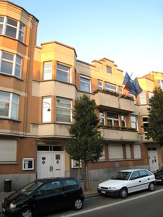
Berchem-Sainte-Agathe or Sint-Agatha-Berchem, often simply called Berchem, is one of the 19 municipalities of the Brussels-Capital Region, Belgium. Located in the north-western part of the region, it is bordered by Ganshoren, Koekelberg, and Molenbeek-Saint-Jean, as well as the Flemish municipalities of Asse and Dilbeek. In common with all of Brussels' municipalities, it is legally bilingual (French–Dutch).

<span class="mw-page-title-main">Saint-Josse-ten-Noode</span> Municipality of the Brussels-Capital Region, Belgium

Saint-Josse-ten-Noode or Sint-Joost-ten-Node, often simply called Saint-Josse in French or Sint-Joost in Dutch, is one of the 19 municipalities of the Brussels-Capital Region, Belgium. Located in the north-eastern part of the region, it is bordered by the City of Brussels and Schaerbeek.

<span class="mw-page-title-main">Woluwe-Saint-Pierre</span> Municipality of the Brussels-Capital Region, Belgium

Woluwe-Saint-Pierre or Sint-Pieters-Woluwe is one of the 19 municipalities of the Brussels-Capital Region, Belgium. Located in the eastern part of the region, it is bordered by Etterbeek, Auderghem and Woluwe-Saint-Lambert, as well as the Flemish municipalities of Kraainem and Tervuren. In common with all of Brussels' municipalities, it is legally bilingual (French–Dutch).

Articles related to Belgium include:

<span class="mw-page-title-main">Woluwe</span> Stream in Brussels, Belgium

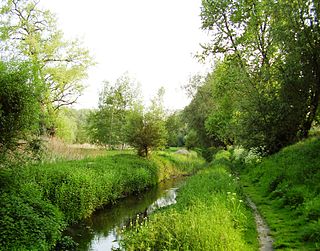
The Woluwe is a stream that goes through several municipalities in the south-east and east of Brussels, Belgium, and is a right tributary of the Senne in Vilvoorde. The Kleine (little) Maalbeek is a tributary of the Woluwe in Kraainem. Many ponds formed along the stream over time, among which the Mellaerts Ponds still exist. The valley of the Woluwe crosses the municipalities of Auderghem, Watermael-Boitsfort, Woluwe-Saint-Pierre, Woluwe-Saint-Lambert, Kraainem, Zaventem, Machelen and Vilvoorde.

<span class="mw-page-title-main">Governor of the Administrative Arrondissement Brussels-Capital</span>

Until 2014, the Governor of the Administrative Arrondissement of Brussels-Capital has the responsibility to enforce laws concerned with public order in the Brussels-Capital Region, one of the three regions of Belgium. The governor's powers are actually quite limited. Just as the Governors of the provinces of Belgium he heads the coordination of all necessary actions and all emergency services during the provincial phase of a disaster on the territory of the Brussels-Capital Region.

<span class="mw-page-title-main">Brussels-Halle-Vilvoorde</span> Former constituency in Belgium

The area within Belgium known as Brussels-Halle-Vilvoorde encompasses the bilingual—French and Dutch—Brussels-Capital Region, which coincides with the arrondissement of Brussels-Capital and the surrounding Dutch-speaking area of Halle-Vilvoorde, which in turn coincides with the arrondissement of Halle-Vilvoorde. Halle-Vilvoorde contains several municipalities with language facilities, i.e. municipalities where French-speaking people form a considerable part of the population and therefore have special language rights. This area forms the judicial arrondissement of Brussels, which is the location of a tribunal of first instance, enterprise tribunal and a labour tribunal. It was reformed in July 2012, as part of the sixth Belgian state reform.

<span class="mw-page-title-main">Watermael-Boitsfort</span> Municipality of the Brussels-Capital Region, Belgium

Watermael-Boitsfort or Watermaal-Bosvoorde, often simply called Boitsfort in French or Bosvoorde in Dutch, is one of the 19 municipalities of the Brussels-Capital Region, Belgium. Located in the south-eastern part of the region, it is bordered by Auderghem, the City of Brussels, Ixelles, and Uccle, as well as the Flemish municipalities of Hoeilaart, Overijse and Sint-Genesius-Rode. In common with all of Brussels' municipalities, it is legally bilingual (French–Dutch).

<span class="mw-page-title-main">Francization of Brussels</span> Post-1700s shift from Dutch to French in the Belgian capital

The Francization of Brussels refers to the evolution, over the past two centuries, of this historically Dutch-speaking city into one where French has become the majority language and lingua franca. The main cause of this transition was the rapid, compulsory assimilation of the Flemish population, amplified by immigration from France and Wallonia.

<span class="mw-page-title-main">Auderghem</span> Municipality of the Brussels-Capital Region, Belgium

Auderghem or Oudergem is one of the 19 municipalities of the Brussels-Capital Region, Belgium. Located in the south-eastern part of the region, along the Woluwe valley and at the entrance to the Sonian Forest, it is bordered by Etterbeek, Ixelles, Watermael-Boitsfort, and Woluwe-Saint-Pierre, as well as the Flemish municipalities of Tervuren and Overijse. In common with all of Brussels' municipalities, it is legally bilingual (French–Dutch).

<span class="mw-page-title-main">Politics and government of the Brussels-Capital Region</span>

The government of the Brussels-Capital Region is the political administration of the Brussels Capital Region of Belgium. An election is held every five years. The government is headed by a Minister-President, four ministers and three state secretaries.

Zellik is an urbanised town with over 8,000 inhabitants in the municipality of Asse, in the province of Flemish Brabant, Belgium. As a suburb on the northwest edge of Brussels, it is separated from the rest of the agglomeration by the R0 ring road around the city. It is close to the municipalities of Jette, Ganshoren and Sint-Agatha-Berchem, which lie to the east.

<span class="mw-page-title-main">Brussels Ring</span> Large ring road of Brussels, Belgium

The Brussels Ring, numbered R0, is a ring road surrounding the Brussels-Capital Region, as well as other smaller towns south of Brussels. It is about 75 kilometres (47 mi) long, with two or three lanes in each direction. While most of it is classified as a motorway (highway), part of it is merely an express route. It crosses the three regions of Belgium: its main part is situated in Flanders, whereas Wallonia comprises 18.2 kilometres (11.3 mi) of the total stretch and 5.5 kilometres (3.4 mi) is on Brussels territory.

<span class="mw-page-title-main">Brussels tram route 19</span> Tram route in Brussels, Belgium

The tram route 19 in Brussels, Belgium, is a tram route operated by STIB/MIVB, which connects the Flemish town of Groot-Bijgaarden in the municipality of Dilbeek to the De Wand stop in Laeken in the City of Brussels.

<span class="mw-page-title-main">Church of St. Clement, Watermael-Boitsfort</span> Church in Watermael-Boitsfort, Belgium

The Church of St. Clement is a Roman Catholic church in the municipality of Watermael-Boitsfort in Brussels, Belgium. It is one of the earliest examples of Romanesque architecture in Belgium, dating from the 11th century.

References

  1. "The Belgian Constitution (English version)" (PDF). Belgian House of Representatives. January 2009. Archived from the original (PDF) on 2011-07-06. Retrieved 2009-06-05. Article 3: Belgium comprises three Regions: the Flemish Region, the Walloon Region and the Brussels Region. Article 4: Belgium comprises four linguistic regions: the Dutch-speaking region, the French speaking region, the bilingual region of Brussels-Capital and the German-speaking region.
  2. "Brussels-Capital Region: Creation". Centre d'Informatique pour la Région Bruxelloise (Brussels Regional Informatics Center). 2009. Archived from the original on 29 April 2009. Retrieved 2009-06-05. Since 18 June 1989, the date of the first regional elections, the Brussels-Capital Region has been an autonomous region comparable to the Flemish and Walloon Regions. (All text and all but one graphic show the English name as Brussels-Capital Region.)
  3. "Communes of the Brussels-Capital Region". Centre d'Informatique pour la Région Bruxelloise (Brussels Regional Informatics Center). 2009. Archived from the original on 2004-06-06. Retrieved 2009-04-05.
  4. 1 2 "Managing across levels of government" (PDF). OECD. 1997. pp. 107, 110. Archived from the original (PDF) on 2008-08-19. Retrieved 2009-04-05.
  5. 1 2 Picavet, Georges (29 April 2003). "Municipalities (1795-now)". Georges Picavet. Retrieved 2009-04-05.
  6. "Anderlecht". CIBG. 2015. Retrieved 2015-11-19.
  7. "Auderghem/Oudergem". CIBG. 2015. Retrieved 2015-11-19.
  8. "Berchem-Sainte-Agathe/Sint-Agatha-Berchem". CIBG. 2015. Retrieved 2015-11-19.
  9. "City of Brussels". CIBG. 2015. Retrieved 2015-11-19.
  10. "Etterbeek". CIBG. 2015. Retrieved 2015-11-19.
  11. "Evere". CIBG. 2015. Retrieved 2015-11-19.
  12. "Forest/Vorst". CIBG. 2015. Retrieved 2015-11-19.
  13. "Ganshoren". CIBG. 2015. Retrieved 2015-11-19.
  14. "Ixelles/Elsene". CIBG. 2015. Retrieved 2015-11-19.
  15. "Jette". CIBG. 2015. Retrieved 2015-11-19.
  16. "Koekelberg". CIBG. 2015. Retrieved 2015-11-19.
  17. "Molenbeek-Saint-Jean/Sint-Jans-Molenbeek". CIBG. 2015. Retrieved 2015-11-19.
  18. "Saint-Gilles/Sint-Gillis". CIBG. 2015. Retrieved 2015-11-19.
  19. "Saint-Josse-ten-Noode/Sint-Joost-ten-Node". CIBG. 2015. Retrieved 2015-11-19.
  20. "Schaerbeek/Schaarbeek". CIBG. 2015. Retrieved 2015-11-19.
  21. "Uccle". CIBG. 2015. Retrieved 2015-11-19.
  22. "Watermael-Boitsfort/Watermaal-Bosvoorde". CIBG. 2015. Retrieved 2015-11-19.
  23. "Woluwe-Saint-Lambert/Sint-Lambrechts-Woluwe". CIBG. 2015. Retrieved 2015-11-19.
  24. "Woluwe-Saint-Pierre/Sint-Pieters-Woluwe". CIBG. 2015. Retrieved 2015-11-19.