The primary reason that Atlanta does not have an abundance of older structures is that the vast majority of pre-civil war buildings were destroyed in Sherman's March to the Sea, in which General William T. Sherman and his Union troops burned nearly every structure in Atlanta during the Civil War. Thus, those pre-civil war buildings that remain are heavily protected by various government programs and designations due to their scarcity.
Oldest structures in Atlanta
The Oldest structures within the current city limits and still in its original location are:
1840 Joseph Willis House, home of early pioneer Joseph Willis and his Family, near the former Creek Indian village of Utoy in SW Atlanta. In 1864 the Home served as headquarters of Brigadier General Jacob D. Cox, commander 3rd Division US XXIII Army Corps (Army of the Ohio) during the siege of Atlanta. The "bomb proof house" written about by Cox, in which three families survived the siege of Atlanta in August 1864, still exists. Mr. Willis remarked he lived in three counties, Henry, DeKalb and Fulton and never moved a single time. His grist mill was one mile south of his home along a tributary of Utoy Creek. His closest neighbor was Atlanta's first physician, Dr. Joshua Gilbert, whose home was in the current Cascade Nature Preserve (site of the battle of Utoy Creek). Dr. Mary Edwards Walker worked in the 14th Corps Hospital behind the home in August 1864.
1860 Cascade Mansion, home of Dr. William F Poole, son-in-law of Atlanta's first physician, 1530 Dodson Drive SW
As far as cemeteries are concerned, Utoy Cemetery, circa 1826, is Atlanta's oldest. Atlanta's first physician and DeKalb County's first sheriff are buried at the site.[1][2]Oakland Cemetery was begun in 1850.
The oldest structure now within city limits, but which originally stood outside the current city limits is the:
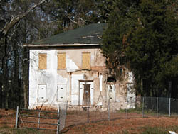
Holland House (demolished). Built in 1842 or 1848, this was the oldest house in Atlanta still standing in the early 1900s.
In the early 1900s, the oldest house in the city was the Holland House, built in 1842[3] or 1848.[4] It originally had stood at the northeast corner of Whitehall (now Peachtree St. SE) and Alabama streets. It was later moved to what is now Trinity Ave., on the north side between Peachtree and Forsyth street.[5] The site is now a parking lot.
Thereafter, one of the oldest houses in the city was the Huff House, built in 1855, upon the foundations of an older building dating from 1830.[6] It was located at the northeast corner of Huff Road and Ellsworth Industrial Ave,[7] overlooking the site of the Battle of Peachtree Creek. The house was razed in 1954 to build a factory on the site.[8]
The former oldest structure with an Atlanta postal address was the Goodwin House, built in 1831. It was located at 3931 Peachtree Road in Brookhaven, Georgia, 0.5 miles (0.80km) east of the Atlanta city limits. The house was dismantled and moved to an undisclosed location in 2016.[9]
Other structures notable for their age
1840 Joseph Willis House – 1571 Willis Mill Road. SW, Atlanta, GA 30311 ref Cox, Jacob Donaldson: Atlanta, published by Scribners 1880., Garrett, Franklin, Thomas: Atlanta and its Environs, 1930, Adams Park
1840 Tulie Smith House (Moved to Atlanta) on the site of the Atlanta Historical Society
↑ "From the description in My 80 Years in Atlanta and from Mr. Hannah of Howell Station and Robert Haywood of Murray Co., the site of the house was at the top of the hill at the northeast corner of Huff Road and Ellsworth Industrial Avenue," on "The Huff House", Marietta Street Artery website
This page is based on this Wikipedia article Text is available under the CC BY-SA 4.0 license; additional terms may apply. Images, videos and audio are available under their respective licenses.