List of parks in Brisbane

Last updated

This is a list of major parks, gardens, and nature reserves in Brisbane, Queensland, Australia.

Boondall Wetlands Boondall Wetlands (6968543386).jpg
Boondall Wetlands
City Botanic Gardens Brisbane City Botanic Gardens lawn.jpg
City Botanic Gardens
South Bank Parklands 28 - South Bank Parklands (4741163759).jpg
South Bank Parklands
NameSuburbEstablishedArea
ANZAC Square CBD [1] 1930 [1] 5,000m² [1]
Boondall Wetlands Boondall 199315 km2
Bowen Park Bowen Hills [2] 1863 [2] 17,740m² [2]
Brisbane Botanic Gardens Mount Coot-tha 1970520,000m²
City Botanic Gardens CBD 1855200,000m²
Hardgrave Park Petrie Terrace -10,800m² [3]
Kalinga Park Clayfield 1910196,600m² [4]
Kianawah Park Tingalpa
King Edward Park CBD -4,900m² [5]
Mowbray Park East Brisbane 190432,000m²
Musgrave Park South Brisbane 185663,225m²
New Farm Park New Farm 1914150,000m² [6]
Newstead Park Newstead [7] 1846 [7] 32,100m² [8]
Post Office Square CBD 19843,300m² [9]
Queens Gardens CBD 1963
Raymond Park, Brisbane Kangaroo Point 1913~ 24,281m²
Rocks Riverside Park Seventeen Mile Rocks 2003260,000m²
Roma Street Parkland CBD 2001160,000m² [10]
South Bank Parklands South Brisbane 1992175,000m²
Whites Hill Holland Park 19341.7 km2
Wickham Park CBD, Spring Hill -19,100m² [11]
Yeronga Memorial Park Yeronga [12] 1882 [12] 224,600m² [12]

Related Research Articles

<span class="mw-page-title-main">Albion, Queensland</span> Suburb of Brisbane, Queensland, Australia

Albion is an inner north-eastern suburb in the City of Brisbane, Queensland, Australia. In the 2016 census, Albion had a population of 2,296 people.

<span class="mw-page-title-main">Herston, Queensland</span> Suburb of Brisbane, Queensland, Australia

Herston is an inner suburb of the City of Brisbane, Queensland, Australia. In the 2021 census, Herston had a population of 2,311 people.

<span class="mw-page-title-main">Toowong</span> Suburb of Brisbane, Queensland, Australia

Toowong is a riverside suburb in the City of Brisbane, Queensland, Australia. In the 2021 census, Toowong had a population of 12,556 people with a median weekly household income of $1,927.

<span class="mw-page-title-main">Holland Park, Queensland</span> Suburb of Brisbane, Queensland, Australia

Holland Park is a southern suburb in the City of Brisbane, Queensland, Australia. In the 2016 census, Holland Park had a population of 8,111 people.

<span class="mw-page-title-main">New Farm, Queensland</span> Suburb of Brisbane, Queensland, Australia

New Farm is an inner northern riverside suburb in the City of Brisbane, Queensland, Australia. In the 2021 census, New Farm had a population of 12,454 people.

<span class="mw-page-title-main">Woolloongabba</span> Suburb of Brisbane, Queensland, Australia

Woolloongabba is a suburb in the City of Brisbane, Queensland, Australia. In the 2016 census, Woolloongabba had a population of 5,631 people.

<span class="mw-page-title-main">Wickham Park, Brisbane</span> Park in Brisbane, Australia

Wickham Park is a park at 330 Wickham Terrace, Spring Hill, Brisbane, Queensland, Australia.

<span class="mw-page-title-main">Post Office Square, Brisbane</span>

Post Office Square is a public square in Brisbane, Australia. It is located between Queen Street and Adelaide Street in the Brisbane CBD, and has an area of 3,300m².

<span class="mw-page-title-main">Newstead House, Brisbane</span> Mansion in Brisbane, Australia

Newstead House is Brisbane's oldest surviving residence and is located on the Breakfast Creek bank of the Brisbane River, in the northern Brisbane suburb of Newstead, in Queensland, Australia. Built as a small cottage in the Colonial-Georgian style in 1846, the cottage was extended and today is painted and furnished in a late Victorian style.

<span class="mw-page-title-main">Newstead, Queensland</span> Suburb of Brisbane, Queensland, Australia

Newstead is an inner northern riverside suburb of Brisbane, Queensland, Australia. At the 2021 census, it had a population of 7,496.

<span class="mw-page-title-main">Brisbane central business district</span> Suburb of Brisbane, Queensland, Australia

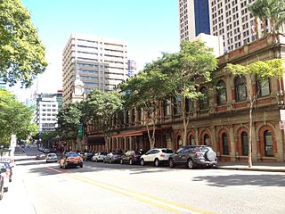
Brisbane City is the central suburb and central business district of Brisbane, the state capital of Queensland, Australia. It is colloquially referred to as the "Brisbane CBD" or "the city". It is located on a point on the northern bank of the Brisbane River, historically known as Meanjin, Mianjin or Meeanjin in the local Aboriginal Australian dialect. The triangular shaped area is bounded by the median of the Brisbane River to the east, south and west. The point, known at its tip as Gardens Point, slopes upward to the north-west where the city is bounded by parkland and the inner city suburb of Spring Hill to the north. The CBD is bounded to the north-east by the suburb of Fortitude Valley. To the west the CBD is bounded by Petrie Terrace, which in 2010 was reinstated as a suburb.

<span class="mw-page-title-main">Queen Street, Brisbane</span> Street in Brisbanes CBD

Queen Street is the main street of Brisbane, the capital of Queensland, Australia. It is named after Queen Victoria of the United Kingdom.

<span class="mw-page-title-main">Teneriffe, Queensland</span> Suburb of Brisbane, Queensland, Australia

Teneriffe is an inner suburb of Brisbane, Queensland, Australia, 2.5 kilometres (1.6 mi) north-east of the CBD. In the 2016 census, Teneriffe had a population of 5,335 people.

<span class="mw-page-title-main">East Brisbane, Queensland</span> Suburb of Brisbane, Queensland, Australia

East Brisbane is an inner southern suburb of the City of Brisbane, Queensland, Australia. In the 2016 census, East Brisbane had a population of 5,934 people.

<span class="mw-page-title-main">George Street, Brisbane</span> Street in Brisbane, Queensland

George Street is a major street located in the Brisbane CBD in Brisbane, Queensland, Australia.

<span class="mw-page-title-main">Graceville, Queensland</span> Suburb of Brisbane, Queensland, Australia

Graceville is a suburb in the City of Brisbane, Queensland, Australia. In the 2021 census, Graceville had a population of 4,764 people.

<span class="mw-page-title-main">Adelaide Street, Brisbane</span> Street in Brisbane, Queensland

Adelaide Street is a major street in Brisbane, Queensland, Australia. It runs between and parallel to Queen Street and Ann Street.

<span class="mw-page-title-main">Ann Street, Brisbane</span> Street in Brisbane, Queensland

Ann Street runs parallel to Adelaide Street and is the northernmost street in the Brisbane CBD in Queensland, Australia. The street is named for Anne, Queen of Great Britain, as part of the CBD street naming series of female British royalty. It is a major thoroughfare, linking as a four-lane one-way street the suburb of Fortitude Valley in the northeast with the Riverside Expressway in the southwest; house numbers run the opposite direction.

<span class="mw-page-title-main">City of Brisbane</span> Local government area in Queensland, Australia

The City of Brisbane is a local government area (LGA) which comprises the inner portion of the metropolitan area of Brisbane, the capital of Queensland, Australia. Its governing body is the Brisbane City Council.

<span class="mw-page-title-main">Conrad Gargett</span> Australian architecture and design practice

Conrad Gargett is an Australian architecture and design practice. It was founded in Brisbane in 1890 and is one of Queensland's oldest architectural firms.

References

  1. 1 2 3 "Anzac Square (entry 600062)". Queensland Heritage Register . Queensland Heritage Council. Retrieved 13 July 2015.
  2. 1 2 3 "Bowen Park (entry 601523)". Queensland Heritage Register . Queensland Heritage Council. Retrieved 13 July 2015.
  3. "Hardgrave Park". RikWare Pty Ltd. Retrieved 25 September 2014.
  4. "Kalinga Park". RikWare Pty Ltd. Retrieved 25 September 2014.
  5. "King Edward Park". RikWare Pty Ltd. Retrieved 25 September 2014.
  6. "New Farm Park". Boobobutt. Retrieved 7 March 2022.
  7. 1 2 "Newstead House and Park (entry 600265)". Queensland Heritage Register . Queensland Heritage Council. Retrieved 13 July 2015.
  8. "Newstead Park". RikWare Pty Ltd. Retrieved 25 September 2014.
  9. "Post Office Square". RikWare Pty Ltd. Retrieved 25 September 2014.
  10. "Roma Street Parkland". Boobobutt. Retrieved 7 March 2022.
  11. "Wickham Park". RikWare Pty Ltd. Retrieved 25 September 2014.
  12. 1 2 3 "Yeronga Memorial Park (entry 602462)". Queensland Heritage Register . Queensland Heritage Council. Retrieved 13 July 2015.

Commons-logo.svg Media related to Parks in Brisbane at Wikimedia Commons