List of public art in Somerset

Last updated

Districts of Somerset
County council area
Unitary
Somerset numbered districts 2019.svg
1 South Somerset
2 Somerset West and Taunton
3 Sedgemoor
4 Mendip
5 Bath and North East Somerset
6 North Somerset

This is a list of public art in the Somerset county of England. This list applies only to works of public art on permanent display in an outdoor public space. For example, this does not include artworks in museums.

Contents

The ceremonial county of Somerset consists of a non-metropolitan county, administered by Somerset County Council, which is divided into four districts, and two unitary authorities. The districts of Somerset are Somerset West and Taunton, South Somerset, Mendip and Sedgemoor. The two administratively independent unitary authorities, which were established on 1 April 1996 following the breakup of the county of Avon, are North Somerset and Bath and North East Somerset. These unitary authorities include areas that were once part of Somerset before the creation of Avon in 1974. [1]

Public art is art in any media that has been planned and executed with the intention of being staged in the physical public domain, usually outside and accessible to all. Public art is significant within the art world, amongst curators, commissioning bodies and practitioners of public art, to whom it signifies a working practice of site specificity, community involvement and collaboration. Public art may include any art which is exhibited in a public space including publicly accessible buildings, but often it is not that simple. Rather, the relationship between the content and audience, what the art is saying and to whom, is just as important if not more important than its physical location. [2]


Bath and North East Somerset

Bath and North East Somerset (commonly referred to as BANES or B&NES) is a unitary authority created on 1 April 1996, following the abolition of the County of Avon. [3] It occupies an area of 220 square miles (570 km2), two-thirds of which is green belt. [4] BANES stretches from the outskirts of Bristol, south into the Mendip Hills and east to the southern Cotswold Hills and Wiltshire border. [4] The city of Bath is the principal settlement in the district, but BANES also covers Keynsham, Midsomer Norton, Radstock and the Chew Valley. BANES has a population of 170,000, about half of whom live in Bath, making it 12 times more densely populated than the rest of the district. [4]

ImageTitle / subjectLocation and
coordinates
DateArtist / designerTypeMaterialDimensionsDesignationOwner / administrator Wikidata Notes
Sir Bevil Grenville monument.JPG
More images
Sir Bevil Grenville's Monument Lansdown Hill

51°25′53″N2°23′58″W / 51.431389°N 2.399444°W / 51.431389; -2.399444
1720 Ashlar stone masonry,25 feet (8 m) high.Grade II* listed building, scheduled monument [5] [6] [7] [8] Q7526126
Queen Square Obelisk 4.jpg
More images
Frederick, Prince of Wales Queen Square, Bath 1738 John Wood, the Elder ObeliskStone15m tallGrade II* listed buildingShortened after a gale in 1815. [9] [10]
Bath victoria memorial 1.JPG
More images
Queen Victoria Jubilee Obelisk Royal Victoria Park, Bath

51°23′10″N2°22′23″W / 51.3862°N 2.3731°W / 51.3862; -2.3731
1837G.P. Manners (architect)ObeliskStoneGrade II* Q1752215
Bath memorial edward 7 parade gardens.JPG
More images
Edward VII Parade Gardens, Bath c.1911 Newbury Abbot Trent [11] Statue on pedestalBronze & Portland stoneGrade II Q26673296
Rvpgreatdelstatue.JPG Jupiter Royal Victoria Park, Bath

51°23′10″N2°22′23″W / 51.3862°N 2.3731°W / 51.3862; -2.3731
1839John Osborne Bath Stone Head 183 centimetres (72 in) high. Base and pedestal 600 centimetres (240 in) high. [12]
Memorial to the flood, Woollard - geograph.org.uk - 482604.jpg Memorial to the 1968 floodBy the River Chew in Woollard

51°22′42″N2°31′47″W / 51.3784°N 2.5298°W / 51.3784; -2.5298
Stone, from destroyed bridge and plaque
Ralph Allens Castle - geograph.org.uk - 1762356.jpg Sham Castle Bathampton

51°22′57″N2°20′15″W / 51.3825°N 2.3375°W / 51.3825; -2.3375
1755 Sanderson Miller StoneGrade II* listed building Q7487351
Statue on Royal Avenue, Bath 1.jpg Medici lions Royal Victoria Park, Bath

51°23′03″N2°21′53″W / 51.3843°N 2.3646°W / 51.3843; -2.3646
Rebecca Fountain - Bath, England - DSC09886.jpg
More images
Rebecca FountainBeside Bath Abbey 1859, erected 1861Rushton Walker of BristolSculpture and fountainStone and marbleGrade II Q26674838 [13]
Queen Victoria, Victoria Art Gallery.jpg
More images
Queen Victoria Exterior of Victoria Art Gallery, Bathc.1897 Andrea Carlo Lucchesi Sculpture and surroundStone [14]
NCR24 milepost.jpg Fossil Tree milepost on National Cycle Route 24 Near Radstock

51°17′50″N2°25′29″W / 51.2972°N 2.4247°W / 51.2972; -2.4247
John Mills
RadstockMineWheel.jpg Somerset coalfield Radstock

51°17′37″N2°26′55″W / 51.2936°N 2.4485°W / 51.2936; -2.4485

Mendip

Mendip is a local government district which covers a largely rural area of 285 square miles (738 km2) [15] ranging from the Mendip Hills through on to the Somerset Levels. It has a population of approximately 11,000. [15] The administrative centre of the district is Shepton Mallet.

ImageTitle / subjectLocation and
coordinates
DateArtist / designerTypeMaterialDimensionsDesignationOwner / administrator Wikidata Notes
War memorial, St. Cuthberts Parish Church, Wells.jpg
More images
War memorialSt. Cuthberts Parish Church, Wellsc.1920Lantern cross with plaquesStone & bronze4m tallGrade II listed building Q26663082 [16] [17]
Bishop's Palace, Wells. Adam and Eve sculpture.jpg Adam and Eve Bishop's Palace, Wells

51°12′33″N2°38′32″W / 51.209111°N 2.642105°W / 51.209111; -2.642105
E. J. Clack SculptureWood [18]
Bishop's Palace, Wells. Sculpture.jpg The Weight of Our Sins Bishop's Palace, Wells

51°12′33″N2°38′32″W / 51.209111°N 2.642105°W / 51.209111; -2.642105
2010 Josefina de Vasconcellos Sculpture groupBronze [19]
Sculpture No 4, by Mary Spencer Watson, North Porch, Wells Cathredral.jpg
More images
Four Symbols of the EvangelistsApproach to the North Porch of Wells Cathedral 1992-93 Mary Spencer Watson Four sculpturesPurbeck stone [20]
Hoodmonument.jpg
More images
Admiral Hood Monument Compton Dundon

51°06′05″N2°43′17″W / 51.101356°N 2.721306°W / 51.101356; -2.721306
1831 Henry Goodridge Tuscan column Ashlar 110 feet (33.5 m) highGrade II* listed building Q4683688
Romulus, Remus and the Wolf - geograph.org.uk - 128687.jpg Romulus and Remus

51°14′20″N2°37′00″W / 51.2390°N 2.6166°W / 51.2390; -2.6166
1945Gaetano CelestraBonded cast concreteCreated by Gaetano Celestra, an Italian prisoner of war at a nearby camp. [21] [22]
Sculpture at the West Mendip Hospital - geograph.org.uk - 231265.jpg CelebrationSite of West Mendip Hospital, Horrington

51°09′32″N2°42′02″W / 51.1589°N 2.7006°W / 51.1589; -2.7006
2005James BluntSculpture group
Mells Somerset2.JPG
More images
Mells War Memorial Mells

51°14′26″N2°23′22″W / 51.240429°N 2.389446°W / 51.240429; -2.389446
1921 Sir Edwin Lutyens War memorial Purbeck marble Grade II* listed building Q17552180

North Somerset

North Somerset is a unitary authority which is administered independently of the non-metropolitan county of Somerset. [23] Its administrative headquarters are located in the town hall of Weston-super-Mare, and has a resident population of 193,000 living in 85,000 households. [24]

ImageTitle / subjectLocation and
coordinates
DateArtist / designerTypeMaterialDimensionsDesignationOwner / administrator Wikidata Notes
Grove Park War Memorial.jpg
More images
War memorialGrove Park, Weston-super-Mare 1922 Alfred Drury Statue on pedestalBronze and stoneGrade II Q26677665 [25] [26]
Westernsilica.JPG
More images
SilicaBig Lamp Junction, Weston-super-Mare

51°20′50″N2°58′34″W / 51.3471°N 2.9761°W / 51.3471; -2.9761
2006 Wolfgang Buttress 4 metres (13 ft) wide at the base. 30 metres (98 ft) high. [27] [28] North Somerset CouncilLit by LEDs at night [29]
The craftsman (geograph 2839284).jpg
More images
The Glassblower Nailsea

51°26′03″N2°45′14″W / 51.4342°N 2.7540°W / 51.4342; -2.7540
2008 [30] Vanessa Marston BronzeNailsea Town Council
The Seafarers' Memorial, Battery Point, Portishead - geograph.org.uk - 339440.jpg Seafarer's Memorial Portishead

51°29′41″N2°46′24″W / 51.4947°N 2.7733°W / 51.4947; -2.7733
2005Stone
Carved stone head - geograph.org.uk - 1281377.jpg Carved head Leigh Woods

51°26′47″N2°39′18″W / 51.4464°N 2.6549°W / 51.4464; -2.6549
Stone
Portishead MMB 17 Marina.jpg Full Fathom Five Portishead

51°29′29″N2°45′15″W / 51.4915°N 2.7543°W / 51.4915; -2.7543
Michael Dan Archer Stone108 granite columns [31]

Sedgemoor

Sedgemoor district is a low-lying area of land close to sea level between the Quantock and Mendip hills, historically largely marsh (or moor). It contains the bulk of the area also known as the Somerset Levels, including Europe's oldest known engineered roadway, the Sweet Track. [32]

ImageTitle / subjectLocation and
coordinates
DateArtist / designerTypeMaterialDimensionsDesignationOwner / administrator Wikidata Notes
Robert Blake statue at bridgwater.jpg
More images
Admiral Robert Blake Bridgwater

51°07′42″N3°00′14″W / 51.1282°N 3.0039°W / 51.1282; -3.0039
1898 F. W. Pomeroy Statue on pedestalBronze, limestone and graniteGrade II* [33] Bridgwater Town Council Q30625603
The Willow Man - geograph.org.uk - 472863.jpg
More images
Willow Man

51°09′02″N2°58′52″W / 51.15046°N 2.9812°W / 51.15046; -2.9812
2000 [34] Serena de la Hey Sculpture Black maul willow withies over steel frame. [35] 40 feet (12 m) high. Q2899308 Burnt down in 2001 and rebuilt. [36]
SomersetSpaceWalk-The Sun (open side).jpg
More images
Somerset Space Walk Bridgwater and Taunton Canal

51°03′45″N2°59′20″W / 51.0626°N 2.9888°W / 51.0626; -2.9888
1997 Pip Youngman Sculpture22-kilometre (14-mile) long Q7559907
Spirit of Carnival - geograph.org.uk - 152530.jpg West Country Carnival Bridgwater

51°07′42″N3°00′14″W / 51.1284°N 3.0039°W / 51.1284; -3.0039
2005Statue on pedestalBronze
King Alfred's Monument, Athelney 05.jpg
More images
Alfred the Great Athelney

51°03′33″N2°56′05″W / 51.0593°N 2.9346°W / 51.0593; -2.9346
1801 Sir John Slade, 1st Baronet ObeliskStoneGrade II listed building Q26468579 Site of Athelney Abbey. [37] [38]
Riverparrettseat.jpg West bank of the Parrett Estuary, a mile from the village of Combwich

51°09′42″N3°02′54″W / 51.1617°N 3.0482°W / 51.1617; -3.0482
1996SculptureWood

South Somerset

The South Somerset district occupies an area of 370 square miles (958 km2), [39] stretching from its borders with Devon and Dorset to the edge of the Somerset Levels. The district has a population of about 158,000, [40] and has Yeovil as its administrative centre.

ImageTitle / subjectLocation and
coordinates
DateArtist / designerTypeMaterialDimensionsDesignationOwner / administrator Wikidata Notes
Industria Virtute Et Labore - geograph.org.uk - 360943.jpg Industria Virtute Et Labore Yeovil
Burton Pynsent Monument.jpg
More images
Burton Pynsent Monument Curry Rivel

51°01′18″N2°53′21″W / 51.021667°N 2.889167°W / 51.021667; -2.889167
1767 Capability Brown Portland Stone 140 feet (43 m) highGrade I listed building [41] Q5000900
Sculpture at Dillington House - geograph.org.uk - 492401.jpg Dillington House
King Alfred's Tower view from west.jpg
More images
King Alfred's Tower Brewham

51°06′54″N2°21′54″W / 51.115°N 2.365°W / 51.115; -2.365
1769-177249 metres (161 ft) highGrade I listed building Q7884143
Fore Street, Chard - geograph.org.uk - 1175237.jpg Ball and Whirl Fore Street, Chard

50°52′22″N2°57′49″W / 50.8728°N 2.9635°W / 50.8728; -2.9635
1991 Neville Gabie Bronze
Jack The Treacle Eater 2.jpg Jack The Treacle Eater Barwick

50°55′32″N2°37′23″W / 50.9256°N 2.6231°W / 50.9256; -2.6231
c. 1920sStone South Somerset District Council
Barwick Fish Tower.jpg Fish Tower Barwick

50°55′49″N2°37′38″W / 50.9304°N 2.6273°W / 50.9304; -2.6273
c. 1920s South Somerset District Council
Barwick Cone.jpg Cone Barwick

50°55′26″N2°37′56″W / 50.9238°N 2.6321°W / 50.9238; -2.6321
c. 1920s75 feet (23 m) high South Somerset District Council

Somerset West and Taunton

Somerset West and Taunton has borough status. The district covers a population of approximately 150,000 [42] in an area of 459.5 square miles (1,190 km2). [43] The major settlements are the town of Taunton, where around 60,000 of the population live, [44] Minehead which has population 10,000.

ImageTitle / subjectLocation and
coordinates
DateArtist / designerTypeMaterialDimensionsDesignationOwner / administrator Wikidata Notes
Wellington Monument, Somerset.jpg
More images
Wellington Monument Blackdown Hills

50°56′53″N3°13′45″W / 50.9480°N 3.2293°W / 50.9480; -3.2293
1854 Thomas Lee Triangular towerCalcareous Grit80 feet (24 m) wide at the base and 53.34 metres (175.0 ft) high.Grade II* listed building Q7981443
Vivary Park Fountain - geograph.org.uk - 1195083.jpg Queen Victoria Memorial Fountain Vivary Park, Taunton

51°00′27″N3°05′47″W / 51.0074°N 3.0964°W / 51.0074; -3.0964
1907 Q26565782 Made by the Saracen Foundry of Glasgow. [45]
Queen Anne statue Minehead.jpg
More images
Queen Anne Wellington Square, Minehead 1791 Francis Bird Statue & surround Carrara marble Grade II* listed building Q17555996 Moved to current site in 1893. [46] [47]
Ancient mariner statue.jpg
More images
The Ancient Mariner Watchet

51°10′56″N3°19′45″W / 51.182084°N 3.329038°W / 51.182084; -3.329038
2003 Alan Herriot Statue on pedestal7 feet (2.1 m) highWatchet Market House Museum Society [48]
Minehead , South West Coast Path - geograph.org.uk - 1212265.jpg
More images
The Hand That Holds The Map Minehead

51°12′36″N3°28′24″W / 51.2099°N 3.4733°W / 51.2099; -3.4733
2001Owen CunninghamSculptureSteel and welded galvanised iron3 metres (9.8 ft) high and 3 metres (9.8 ft) wideStart of the South West Coast Path. [49]
Statue of John "Yankee Jack" Short at Watchet Marina - geograph.org.uk - 1527853.jpg John Short Watchet

51°10′56″N3°19′45″W / 51.182084°N 3.329038°W / 51.182084; -3.329038
2008 Alan Herriot StatueBronzeWatchet Market House Museum Society [50] [51]
The Acland Cross, Selworthy Woods, West Somerset (2876321658).jpg Memorial to Sir Thomas Dyke Acland Selworthy

51°13′02″N3°33′50″W / 51.2172°N 3.5639°W / 51.2172; -3.5639
Wood7 metres (23 ft) high
Caratacus Stone full view.jpg
More images
Caratacus Stone Exmoor

51°05′26″N3°35′12″W / 51.0905°N 3.5867°W / 51.0905; -3.5867
Possible 6th centuryMonolithStone Ancient monument Q1035420
Sculpture by Wimbleball Lake.jpg Fishing Wimbleball Lake

51°04′00″N3°28′00″W / 51.0666°N 3.4666°W / 51.0666; -3.4666
SculptureWicker

Related Research Articles

<span class="mw-page-title-main">Somerset</span> County in South West England

Somerset is a ceremonial county in South West England. It is bordered by the Bristol Channel, Gloucestershire, and Bristol to the north, Wiltshire to the east and the north-east, Dorset to the south-east, and Devon to the south-west. The largest settlement is the city of Bath, and the county town is Taunton.

<span class="mw-page-title-main">North Somerset</span> District in England

North Somerset is a unitary authority in the ceremonial county of Somerset, England. The council is based in Weston-super-Mare, the area's largest town. The district also contains the towns of Clevedon, Nailsea and Portishead, along with a number of villages and surrounding rural areas. Some southern parts of the district fall within the Mendip Hills, a designated Area of Outstanding Natural Beauty.

<span class="mw-page-title-main">History of Somerset</span>

Somerset is a historic county in the south west of England. There is evidence of human occupation since prehistoric times with hand axes and flint points from the Palaeolithic and Mesolithic eras, and a range of burial mounds, hill forts and other artefacts dating from the Neolithic, Bronze and Iron Ages. The oldest dated human road work in Great Britain is the Sweet Track, constructed across the Somerset Levels with wooden planks in the 39th century BCE.

<span class="mw-page-title-main">Lansdown, Bath</span> Suburb of Bath, England

Lansdown is a suburb of the World Heritage City of Bath, England, that extends northwards from the city centre up a road of the same name. Among its most distinctive architectural features are Lansdown Crescent and Sion Hill Place, which includes a campus of Bath Spa University.

<span class="mw-page-title-main">Compton Martin</span> Village and civil parish in England

Compton Martin is a small village and civil parish within the Chew Valley in Somerset and in the Bath and North East Somerset unitary authority in England. The parish has a population of 508. It lies between Chew Valley Lake and Blagdon Lake, north of the Mendip Hills, approximately 10 miles (16 km) south of Bristol on the A368 road Weston-super-Mare to Bath, between Blagdon and West Harptree.

<span class="mw-page-title-main">West Harptree</span> Human settlement in England

West Harptree is a small village and civil parish in the Chew Valley, Somerset within the unitary district of Bath and North East Somerset. The parish has a population of 439.

<span class="mw-page-title-main">Cameley</span> Human settlement in England

Cameley is a village in the civil parish of Temple Cloud with Cameley, within the Chew Valley in Somerset, and on the northern slopes of the Mendip Hills, in the Bath and North East Somerset Council area just off the A37 road. It is located 11 miles (18 km) from Bristol, Bath and Wells. The nearest town is Midsomer Norton, which is 6 miles (10 km) away. The parish has a population of 1,292 and includes the village of Temple Cloud.

<span class="mw-page-title-main">Burrington, Somerset</span> Human settlement in England

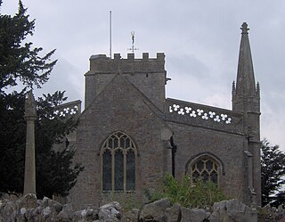
Burrington is a small village and civil parish in Somerset, England. It is situated in the unitary authority of North Somerset, 5 miles (8.0 km) north east of Axbridge and about 10 miles (16 km) east of Weston-super-Mare. The parish includes the hamlets of Bourne and Rickford and has a population of 464.

<span class="mw-page-title-main">Charlcombe</span> Human settlement in England

Charlcombe is a civil parish and small village just north of Bath in the Bath and North East Somerset unitary authority, Somerset, England. The parish had a population of 422 in 2011, and includes the villages of Woolley and Langridge and the hamlet of Lansdown.

<span class="mw-page-title-main">Banwell</span> Human settlement in England

Banwell is a village and civil parish on the River Banwell in the North Somerset district of Somerset, England. Its population was 3,251 according to the 2021 census.

<span class="mw-page-title-main">Culture of Somerset</span> Overview of the culture of Somerset, England

Somerset is a county in the south west of England. It has a varied cultural tradition ranging from the Arthurian legends to The Wurzels, a band specialising in Scrumpy and Western music.

<span class="mw-page-title-main">Grade I listed buildings in Somerset</span> Buildings of exceptional interest in Somerset

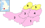
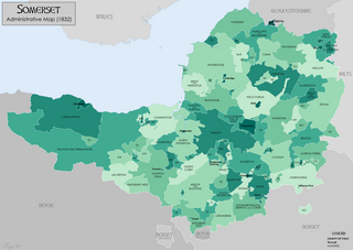
The Grade I listed buildings in Somerset, England, demonstrate the history and diversity of its architecture. The ceremonial county of Somerset consists of a non-metropolitan county, administered by Somerset County Council, which is divided into five districts, and two unitary authorities. The districts of Somerset are West Somerset, South Somerset, Taunton Deane, Mendip and Sedgemoor. The two administratively independent unitary authorities, which were established on 1 April 1996 following the breakup of the county of Avon, are North Somerset and Bath and North East Somerset. These unitary authorities include areas that were once part of Somerset before the creation of Avon in 1974.

<span class="mw-page-title-main">Geography of Somerset</span>

The county of Somerset is in South West England, bordered by the Bristol Channel and the counties of Bristol and Gloucestershire to the north, and Wiltshire to the east, Dorset to the south, and Devon to the west. The climate, influenced by its proximity to the Atlantic Ocean and the prevailing westerly winds, tends to be mild, damp and windy.

<span class="mw-page-title-main">Grade II* listed buildings in Somerset</span>

The ceremonial county of Somerset consists of a non-metropolitan county, administered by Somerset County Council, which is divided into five districts, and two unitary authorities. The districts of Somerset are West Somerset, South Somerset, Taunton Deane, Mendip and Sedgemoor. The two administratively independent unitary authorities, which were established on 1 April 1996 following the breakup of the county of Avon, are North Somerset and Bath and North East Somerset. These unitary authorities include areas that were once part of Somerset before the creation of Avon in 1974.

<span class="mw-page-title-main">Scheduled monuments in Bath and North East Somerset</span>

Bath and North East Somerset is a unitary authority created on 1 April 1996, following the abolition of the County of Avon, which had existed since 1974. Part of the ceremonial county of Somerset, Bath and North East Somerset occupies an area of 220 square miles (570 km2), two-thirds of which is green belt. It stretches from the outskirts of Bristol, south into the Mendip Hills and east to the southern Cotswold Hills and Wiltshire border. The city of Bath is the principal settlement in the district, but BANES also covers Keynsham, Midsomer Norton, Radstock and the Chew Valley. The area has a population of 170,000, about half of whom live in Bath, making it 12 times more densely populated than the rest of the area.

<span class="mw-page-title-main">Scheduled monuments in Somerset</span> Nationally important sites in Somerset, England

There are over 670 scheduled monuments in the ceremonial county of Somerset in South West England. The county consists of a non-metropolitan county, administered by Somerset Council. The two administratively independent unitary authorities, which were established on 1 April 1996 following the breakup of the county of Avon, are North Somerset and Bath and North East Somerset. These unitary authorities include areas that were once part of Somerset before the creation of Avon in 1974.

References

  1. "The Avon (Structural Change) Order 1995". HMSO. Archived from the original on 30 January 2008. Retrieved 9 December 2007.
  2. Knight, Cher Krause (2008). Public Art: theory, practice and populism . Oxford: Blackwell Publishing. ISBN   978-1-4051-5559-5.
  3. "The Avon (Structural Change) Order 1995". Her Majesty's Stationery Office (HMSO). Archived from the original on 30 January 2008. Retrieved 9 December 2007.
  4. 1 2 3 "About the area". Bath and North East Somerset Council. Archived from the original on 4 November 2007. Retrieved 30 December 2007.
  5. "Monument to Sir Bevil Grenville". historicengland.org.uk. English Heritage. Retrieved 20 July 2009.
  6. Historic England. "Sir Bevil Grenville's Monument (1015110)". National Heritage List for England . Retrieved 21 April 2014.
  7. Historic England. "Monument to Sir Bevil Grenville at NGR ST 7219 7034 (1214434)". National Heritage List for England . Retrieved 5 April 2015.
  8. Historic England. "Sir Bevil Grenvilles Monument (1072442)". Research records (formerly PastScape). Retrieved 21 April 2014.
  9. Ison, Walter (2004). The Georgian Buildings of Bath. Spire Books. p. 129. OCLC   604318205.
  10. Historic England. "Queen Square obelisk (443388)". Images of England . Archived from the original on 22 October 2012.
  11. "Edward VII Memorial". Public Monuments & Sculpture Association. Archived from the original on 4 March 2016. Retrieved 27 August 2015.
  12. "Head of Jupiter". Public Monuments and Sculpture Association. Archived from the original on 21 November 2016. Retrieved 27 August 2015.
  13. Historic England. "Rebekah Fountain (1396023)". National Heritage List for England . Retrieved 14 July 2020.
  14. "About, Victoria Art Gallery". Victoria Art Gallery. Retrieved 14 July 2020.
  15. 1 2 "A Portrait of Mendip". Mendip District Council. p. 1. Archived from the original on 4 January 2014. Retrieved 23 May 2017.
  16. "War Memorials Register: St Cuthberts Church Cross". Imperial War Museum . Retrieved 12 July 2020.
  17. Historic England. "War Memorial in churchyard of St Cuthbert approximately 10 metres south of south west corner of church (1383114)". National Heritage List for England . Retrieved 12 July 2020.
  18. "Bishop's Palace, Wells: Adam and Eve". Victoria County History. Archived from the original on 4 March 2016. Retrieved 27 August 2015.
  19. "Don McCullin unveils war sculpture in Wells". BBC. Retrieved 27 August 2015.
  20. Brian Morley (18 March 2006). "Mary Spencer Watson". The Guardian. Retrieved 10 January 2020.
  21. "A39, statue of Romulus and Remus on land at Beechbarrow House, St Cuthbert Out". Somerset Historic Environment Record. Somerset County Council. Archived from the original on 3 October 2016. Retrieved 27 August 2015.
  22. "Romulus and Remus". Public Monuments & Sculpture Association. Archived from the original on 4 March 2016. Retrieved 27 August 2015.
  23. "The Avon (Structural Change) Order 1995". Her Majesty's Stationery Office (HMSO). Archived from the original on 30 January 2008. Retrieved 9 December 2007.
  24. "Local Area Agreement for North Somerset 2007–2010". North Somerset Partnership. Archived from the original on 7 June 2011. Retrieved 30 December 2007.
  25. Historic England. "Grove Park War Memorial, Weston-super-Mare (1430882)". National Heritage List for England . Retrieved 28 January 2021.
  26. "War Memorials Register: Weston Super Mare, Uphill and Kewstoke". Imperial War Museum. Retrieved 28 January 2021.
  27. "Silica". Public Art Online. Archived from the original on 4 March 2016. Retrieved 27 August 2015.
  28. "Silica, 2006, Weston-Super-Mare". Wolfgang Buttress. Archived from the original on 20 November 2016. Retrieved 27 August 2015.
  29. "Silica artwork". North Somerset Council. Archived from the original on 28 September 2011. Retrieved 2 June 2007.
  30. "Glassblower takes pride of place in Nailsea". Weston, Worle and Somerset Mercury. 14 February 2008. Retrieved 23 August 2017.
  31. "Full Fathom Five by Michael Dan Archer". Public Art Portishead. Archived from the original on 21 November 2016. Retrieved 20 November 2016.
  32. "The day the Sweet Track was built". New Scientist, 16 June 1990. Archived from the original on 11 March 2010. Retrieved 26 October 2007.
  33. Historic England. "Details from listed building database (1205747)". National Heritage List for England . Retrieved 27 August 2015.
  34. "40ft sculpture unveiled in Somerset". BBC News. 26 September 2000. Archived from the original on 13 March 2007. Retrieved 10 June 2007.
  35. "Willow Man – 2001". Serena de la Hey. Archived from the original on 19 January 2012. Retrieved 1 January 2012.
  36. "Willow man rises from ashes". BBC News. 19 October 2001. Archived from the original on 21 May 2007. Retrieved 10 June 2007.
  37. Adkins, Lesley and Roy (1992). A Field Guide to Somerset Archaeology. Wimborne, Dorset: Dovecote Press. ISBN   0-946159-94-7.
  38. Historic England. "King Alfred's Monument with railings (1173838)". National Heritage List for England . Retrieved 9 February 2007.
  39. "An introduction to South Somerset" (PDF). South Somerset District Council. Archived (PDF) from the original on 29 November 2014. Retrieved 6 June 2012.
  40. "Population of South Somerset". South Somerset District Council. Archived from the original on 30 October 2007. Retrieved 11 July 2009.
  41. Historic England. "Burton Pynsent Monument (1039561)". National Heritage List for England . Retrieved 5 July 2008.
  42. "Community Profile Somerset West & Taunton" (PDF). Somerset Intelligence Partnership. Retrieved 5 September 2021.
  43. "West Somerset (Local Authority): Key Figures for Physical Environment". Neighbourhood Statistics. Office for National Statistics. Retrieved 23 April 2009.
  44. "Demographics". Taunton Deane Borough Council. Archived from the original on 16 October 2007. Retrieved 25 April 2009.
  45. "News from November 2005". West Somerset Railway. November 2005. Archived from the original on 24 September 2008. Retrieved 26 August 2008.
  46. Historic England. "Statue of Queen Anne (1207015)". National Heritage List for England . Retrieved 2 May 2010.
  47. Byford, Enid (1987). Somerset Curiosities. Dovecote Press. p.  45. ISBN   0946159483.
  48. "Watchet and Samuel Taylor Coleridge". Market House Museum. Archived from the original on 7 April 2015. Retrieved 27 August 2015.
  49. "South Coast Path". Public Monuments& Sculpture Association. Archived from the original on 4 March 2016. Retrieved 27 August 2015.
  50. "Yankee Jack". Victoria County History. Archived from the original on 4 March 2016. Retrieved 27 August 2015.
  51. "Yankee Jack unveiled". Quantock Online. Archived from the original on 15 March 2015. Retrieved 27 August 2015.