List of rivers of Saint Lucia

Last updated

Map all coordinates using: OpenStreetMap  
Download coordinates as: KML
Map of Saint Lucia, with topographic relief. St Lucia map.png
Map of Saint Lucia, with topographic relief.
Map of Saint Lucia (flat). SaintLucia2021OSM.png
Map of Saint Lucia (flat).

This is a list of rivers in the island country of Saint Lucia . Rivers are listed in clockwise order, starting at the north end of the island.

Contents

Rivers

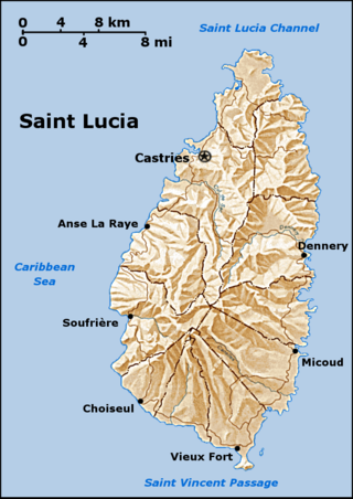
There are 180 streams in Saint Lucia. Most of the rivers empty into the Atlantic Ocean or Caribbean Sea at the coast of Saint Lucia. (The location of the river mouths indicated in this list. Only Roseau and Migny rivers are not on the coast.) The longest river is the Roseau River with a drainage area of 48 km2 (19 sq mi). There are 28 drainage basins for rivers of Saint Lucia. [1] [2] [3] [4] [5]

Rivers in Saint Lucia
OrderNameLocation of mouth
1 Trou Sallé River 14°04′46″N60°55′12″W / 14.07933°N 60.91998°W / 14.07933; -60.91998 (Trou Sallé River)
2 Esperance River [6] 14°03′37″N60°54′45″W / 14.06035°N 60.912549°W / 14.06035; -60.912549 (Esperance River)
3 Dauphin River 14°02′24″N60°53′46″W / 14.039893°N 60.896231°W / 14.039893; -60.896231 (Dauphin River)
4 Trou Grauval River 14°03′29″N60°53′30″W / 14.058146°N 60.891576°W / 14.058146; -60.891576 (Trou Grauval River)
5 Marquis River [6] 14°01′52″N60°53′44″W / 14.031239°N 60.895603°W / 14.031239; -60.895603 (Marquis River)
6 Louvet River [6] 13°57′53″N60°52′48″W / 13.964849°N 60.880013°W / 13.964849; -60.880013 (Louvet River)
7 Fond d'Or River 13°55′23″N60°53′25″W / 13.923034°N 60.890274°W / 13.923034; -60.890274 (Fond D'Or River)
8 Dennery River [6] 13°54′30″N60°53′26″W / 13.908223°N 60.890515°W / 13.908223; -60.890515 (Dennery River)
9 Praslin River
(Rivière des Trois Islets)
13°52′44″N60°53′45″W / 13.878953°N 60.895872°W / 13.878953; -60.895872 (Praslin River)
10 Mamiku River 13°52′18″N60°53′49″W / 13.871644°N 60.896985°W / 13.871644; -60.896985 (Mamiku River)
11 Patience River 13°51′28″N60°53′19″W / 13.857662°N 60.888741°W / 13.857662; -60.888741 (Patience River)
12 Fond River 13°49′56″N60°53′36″W / 13.832279°N 60.893467°W / 13.832279; -60.893467 (Fond River)
13 Volet River [6] 13°49′38″N60°54′01″W / 13.82713°N 60.900247°W / 13.82713; -60.900247 (Volet River)
14 Troumassée River [6] 13°48′46″N60°53′50″W / 13.812815°N 60.897106°W / 13.812815; -60.897106 (Troumassée River)
15 Ger River 13°47′49″N60°54′02″W / 13.79696°N 60.90066°W / 13.79696; -60.90066 (Ger River)
16 Canelles River [6] 13°46′50″N60°54′14″W / 13.780547°N 60.903878°W / 13.780547; -60.903878 (Canelles River)
17 Rouarne River 13°45′59″N60°55′06″W / 13.76643°N 60.918283°W / 13.76643; -60.918283 (Rouarne River)
18 Vieux Fort River [6] 13°43′50″N60°58′07″W / 13.7306°N 60.968675°W / 13.7306; -60.968675 (Vieux Fort River)
18a Little Vieux Fort River
19 Black Bay River [6] 13°44′11″N60°58′51″W / 13.736416°N 60.980721°W / 13.736416; -60.980721 (Black Bay River)
20 Piaye River [6] 13°45′10″N61°01′09″W / 13.752907°N 61.019287°W / 13.752907; -61.019287 (Piaye River)
21 Balembouche River [6] 13°45′15″N61°01′32″W / 13.754224°N 61.025493°W / 13.754224; -61.025493 (Balembouche River)
22 Dorée River [6] 13°45′33″N61°02′15″W / 13.75923°N 61.03755°W / 13.75923; -61.03755 (Dorée River)
23 Trou Barbet River 13°46′42″N61°03′08″W / 13.778265°N 61.052134°W / 13.778265; -61.052134 (Trou Barbet River)
24 Grande Rivière Choiseul 13°46′21″N61°03′02″W / 13.772537°N 61.050564°W / 13.772537; -61.050564 (Grande Rivière Choiseul)
25 L’Ivrogne River [6] 13°47′57″N61°04′03″W / 13.799034°N 61.067587°W / 13.799034; -61.067587 (L’Ivrogne River)
26 Soufrière River [6] 13°51′21″N61°03′38″W / 13.855958°N 61.060629°W / 13.855958; -61.060629 (Soufrière River)
26a Jeremy River
26b Migny River 13°51′13″N61°02′11″W / 13.853701°N 61.036284°W / 13.853701; -61.036284 (Migny River)
27 Mamin River 13°52′15″N61°04′43″W / 13.870753°N 61.078527°W / 13.870753; -61.078527 (Mamin River)
28 Mahaut River 13°53′32″N61°04′25″W / 13.892304°N 61.073487°W / 13.892304; -61.073487 (Mahaut River)
29 Canaries River [6] 13°54′18″N61°04′08″W / 13.904901°N 61.068765°W / 13.904901; -61.068765 (Canaries River)
30 La Verdure River 13°55′12″N61°03′35″W / 13.920047°N 61.059635°W / 13.920047; -61.059635 (La Verdure River)
31 Anse Cochon River 13°55′36″N61°03′24″W / 13.926655°N 61.056695°W / 13.926655; -61.056695 (Anse Cochon River)
32 Grande Rivière de l'Anse la Raye 13°56′21″N61°02′39″W / 13.93915°N 61.04426°W / 13.93915; -61.04426 (Grande Rivière de l'Anse la Raye)
33 Petite Riviere de l'Anse La Raye [6] 13°56′31″N61°02′37″W / 13.942032°N 61.043529°W / 13.942032; -61.043529 (Petite Riviere de l'Anse La Raye)
34 Roseau River [6] 13°57′36″N61°01′57″W / 13.959965°N 61.032363°W / 13.959965; -61.032363 (Roseau River)
34a Millet River 13°55′29″N60°59′22″W / 13.924778°N 60.989491°W / 13.924778; -60.989491 (Millet River)
35 Cul de Sac River [6] 13°59′02″N61°00′40″W / 13.983861°N 61.011162°W / 13.983861; -61.011162 (Cul de Sac River)
36 Castries River [6] 14°00′34″N60°59′38″W / 14.009554°N 60.994019°W / 14.009554; -60.994019 (Castries River)
37 Choc River [6] 14°02′19″N60°58′18″W / 14.038652°N 60.971711°W / 14.038652; -60.971711 (Choc River)
38 Bois d'Orange River 14°03′56″N60°57′59″W / 14.065454°N 60.966516°W / 14.065454; -60.966516 (Bois d'Orange River)

See also

Notes

Breen's list of major rivers in Saint Lucia in 1844 includes a Vide Bouteille River but there is no mention of this river in the current GeoNames database. There is a Vide Bouteille Point on the coast at 14°01′52″N60°58′45″W / 14.03119°N 60.979239°W / 14.03119; -60.979239 (Vide Bouteille Point) . [6] [3]

Related Research Articles

<span class="mw-page-title-main">Geography of Saint Lucia</span> Geography of the island country Saint Lucia

Saint Lucia is one of many small land masses composing the insular group known as the Windward Islands. Unlike large limestone areas such as Florida, Cuba, and the Yucatan Peninsula, or the Bahamas, which is a small island group composed of coral and sand, St. Lucia is a typical Windward Island formation of volcanic rock that came into existence long after much of the region had already been formed.

Roseau is the capital and largest city of Dominica, with a population of 16,571 as of 2023. It is a small and compact urban settlement, in the Saint George parish and surrounded by the Caribbean Sea, the Roseau River and Morne Bruce. Built on the site of the ancient Island Carib village of Sairi, it is the oldest and most important urban settlement on the island of Dominica.

<span class="mw-page-title-main">Dennery District</span> Quarter and town in St. Lucia

Dennery District is one of 10 districts of the Caribbean island nation of Saint Lucia. The seat of Dennery District is the Dennery Village. The main economic activities are fishing, and the cultivation of lima beans, bananas, and other tropical fruit. The population of the quarter was estimated at 12,876 in 2002 and fell to 12,767 in 2010.

<span class="mw-page-title-main">Anse la Raye District</span> District in Saint Lucia

Anse la Raye District is one of 10 districts of the island nation of St. Lucia in the Caribbean Sea. The name Anse la Raye is French for cover/bay of the rays, since there are a large number of skate fish or rays in the bay. In 2005/2010, the population of the district was 6,382/6,060 people, and they are mainly fishers and agricultural workers. The main town in the area takes the same name as the district and is located down the western coast from Castries, the capital of the country.

<span class="mw-page-title-main">Districts of Saint Lucia</span> First-level administrative divisions of Saint Lucia

The island nation of Saint Lucia is divided into 10 districts. The name Quarters or Quartiers originally came from the French period in Saint Lucia. The 2001 and 2010 Census of Saint Lucia refers to the first level administrative divisions as districts. The FIPS and ISO standards regularly called these divisions quarters or quartiers in French. The former district of Dauphin Quarter was merged into Gros Islet District and the former district of Praslin Quarter was merged into Micoud District.

<span class="mw-page-title-main">Cul de Sac River</span> River in Saint Lucia

The Cul De Sac River is a river in Castries Quarter of the island country of Saint Lucia. It flows north and then west from the central highlands in the south of the island, reaching the Caribbean Sea in Grand Cul de Sac Bay, south of the capital, Castries. It is one of the longest rivers in Saint Lucia.

The Canelles River is a river in Saint Lucia. It flows southeast from the central highlands in the south of the island, reaching the Atlantic Ocean to the south of the town of Micoud.

The Roseau River is a river in the Anse-la-Raye Quarter of the island country of Saint Lucia. It flows north and then west from the central highlands in the south of the island, reaching the Caribbean Sea to the north of the town of Anse la Raye. The Roseau river is also the longest in the country and is dammed by the John Compton Dam near Millet.

<span class="mw-page-title-main">Tourism in Saint Lucia</span> Saint Lucia Tourism

Saint Lucia, an island nation in the Caribbean islands, has a relatively large tourism industry. Due to the relatively small land area of the country, most of the governmental promotion is performed by the state-operated Saint Lucia Tourism Authority, led by Executive Chairperson Agnes.

<span class="mw-page-title-main">Roseau Valley</span> Place in Anse la Raye, Saint Lucia

The Roseau Valley is a second-order subdivision in the island nation of St. Lucia. It is home to the island's largest banana plantation. The 2010 population of the Roseau Valley was 227.

<span class="mw-page-title-main">Balembouche River</span> River in Saint Lucia

The Balembouche River is a coastal river in Laborie Quarter, Saint Lucia that flows into the Caribbean Sea.

<span class="mw-page-title-main">Castries River</span> River in Saint Lucia

The Castries River is a river in Castries Quarter on the island country of Saint Lucia.

The Choc River is a river in the Soufrière Quarter of the island country of Saint Lucia. It flows to the Caribbean Sea.

The Esperance River is a river in Gros Islet Quarter in the island country of Saint Lucia.

The Jeremy River (Saint Lucia) is a river of Saint Lucia. It drains from the forest area to the east coast.

The Louvet River is a river of Saint Lucia. It drains from the forest area to the east coast.

The John Compton Dam, formerly known as the Roseau Dam, is a concrete-face rock-fill dam on the Roseau River in the small community of Millet in central Saint Lucia. The primary purpose of the dam is municipal water supply. It is named after John Compton, the former Prime Minister of Saint Lucia, who was influential in its implementation.

References

  1. Higgins, Chris (2001). St. Lucia. Montreal: Ulysses Travel Guides. ISBN   2-89464-396-9.
  2. "Integrating the Management of Watersheds and Coastal Areas in St. Lucia". Water Resources Management Unit, Ministry of Agriculture, Forestry and Fisheries Government of St. Lucia. 2001. Retrieved August 3, 2021.
  3. 1 2 "GEONet Names Server". National Geospatial-Intelligence Agency . Retrieved June 25, 2021., GEOnet Names Server
  4. "Tourist Map". Caribbean On-line. Archived from the original on 2007-10-10. Retrieved August 4, 2021.
  5. Saint Lucia Country Environmental Profile (PDF). Caribbean Conservation Association. p. 44. Retrieved August 11, 2021.
  6. 1 2 3 4 5 6 7 8 9 10 11 12 13 14 15 16 17 18 19 20 21 Breen, Henry H. (1844). St. Lucia: Historical, Statistical, and Descriptive. London: Longman, Brown, Green, and Longmans. p. 10.