This article needs additional citations for verification .(October 2021) |

A list of rock formations worldwide that resemble human beings.
This article needs additional citations for verification .(October 2021) |
A list of rock formations worldwide that resemble human beings.


The Isle of Wight is an island, English county and unitary authority in the English Channel, 2 to 5 miles off the coast of Hampshire, across the Solent. It is the largest and second-most populous island in England. Referred to as "The Island" by residents, the Isle of Wight has resorts that have been popular holiday destinations since Victorian times. It is known for its mild climate, coastal scenery, and verdant landscape of fields, downland, and chines. The island is historically part of Hampshire. The island is designated a UNESCO Biosphere Reserve.
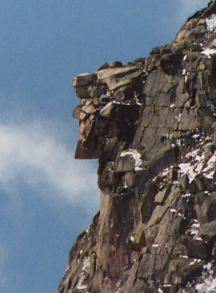
The Old Man of the Mountain, also called the Great Stone Face and the Profile, was a series of five granite cliff ledges on Cannon Mountain in Franconia, New Hampshire, United States, that appeared to be the jagged profile of a human face when viewed from the north. The rock formation, 1,200 feet (370 m) above Profile Lake, was 40 feet (12 m) tall and 25 feet (7.6 m) wide.

A monolith is a geological feature consisting of a single massive stone or rock, such as some mountains. Erosion usually exposes the geological formations, which are often made of very hard and solid igneous or metamorphic rock. Some monoliths are volcanic plugs, solidified lava filling the vent of an extinct volcano.

The Tijuca National Park is an urban national park in the mountains of the city of Rio de Janeiro, Brazil. The park is part of the Atlantic Forest Biosphere Preserve, and is administered by the Chico Mendes Institute for Biodiversity Conservation (ICMBio).

Sleeping Giant, , is a rugged traprock mountain with a high point of 739 feet (225 m), located eight miles (13 km) north of New Haven, Connecticut. A prominent landscape feature visible for miles, the Sleeping Giant receives its name from its anthropomorphic resemblance to a slumbering human figure as seen from either the north or south. The Giant is known for its expansive clifftop vistas, rugged topography, and microclimate ecosystems. Most of the Giant is located within Sleeping Giant State Park. The mountain is a popular recreation site: over 30 miles (48 km) of hiking trails traverse it including 5 miles (8 km) of the 23-mile (37 km) Quinnipiac Trail. Quinnipiac University is located at Mount Carmel's foot in Hamden.
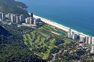
Gávea is an affluent residential neighborhood located in the South Zone of the city of Rio de Janeiro, Brazil. It borders São Conrado, Leblon, Lagoa and Jardim Botânico neighborhoods and is famous for its high concentration of artists. PUC-Rio, as well as several schools, are located in the neighborhood. Gávea is well known because of the "Baixo Gávea" area, which is considered a Bohemian quarter.

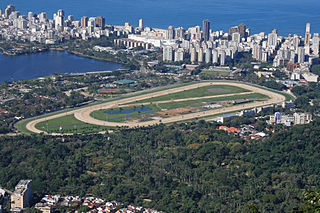
Pedra da Gávea is a monolithic mountain in Tijuca Forest, Rio de Janeiro, Brazil. Composed of granite and gneiss, its elevation is 844 metres (2,769 ft), making it one of the highest mountains in the world that ends directly in the ocean. Trails on the mountain were opened up by the local farming population in the early 1800s; today, the site is under the administration of the Tijuca National Park.
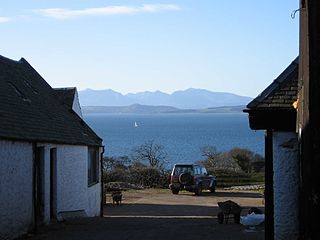
The Sleeping Warrior is the profile of the north Arran hills in Scotland as seen from the Ayrshire coast. It is a well-known site that takes its name from a resemblance to a resting human figure. Various interpretations of the profile exist although the view of the Witches Step and Caisteal Abhail from North Ayrshire and Bute is arguably the most convincing.

Niède Guidon is a Brazilian archaeologist known for her work in pre-historic archeology of South American civilizations and her efforts to secure the conservation of the World Heritage Site Serra da Capivara National Park.
The Badlands Guardian is a geomorphological feature located near Medicine Hat in the southeast corner of Alberta, Canada. The feature was discovered in 2005 by Lynn Hickox through use of Google Earth.
São Conrado is a neighborhood in the South Zone of the city of Rio de Janeiro, Brazil. It is nestled in between the neighborhoods of Barra da Tijuca to the southwest and Leblon to the northeast. The neighborhood takes its name from a small church, Igreja de São Conrado, which was constructed early in the 20th century by Conrado Jacob Niemeyer (1831-1905). São Conrado, which ranks as one of the areas with the highest Human Development Index in Brazil, presents a stark contrast to Rocinha on its border, which is one of the largest and poorest favelas in Brazil.
Profile Rock was a 50-foot high granite rock formation located in Freetown, Massachusetts just outside Assonet village and near the Freetown State Forest. Local Wampanoags believe it to be the image of Chief Massasoit. The Wampanoags occupied the region of Rhode Island and Massachusetts bounded by Narragansett Bay to the west and the Atlantic Ocean to the east, and Chief Massasoit was a close friend to the early Pilgrim settlers.

Capitólio is a Brazilian municipality located in the southwest of the state of Minas Gerais. Its population as of 2020 was 8,663 people living in a total area of 522 km2. The city belongs to the meso-region of Sul e Sudoeste de Minas and to the micro-region of Passos.

Marcahuasi is a plateau in the Andes Mountains, located 60 km east of Lima, on the mountain range that rises to the right bank of the Rímac River. The site is located at 4,000 metres (13,000 ft) above sea level and is known for its unusual geological formations; curious shapes of human faces and animals visible in granite rock.
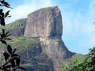
Pedra da Gávea is a mountain in Tijuca Forest, Rio de Janeiro, Brazil. Differential weathering on one side of the rock has created what is described as a stylized human face, and weathered markings on another face of the rock have been described as an inscription. Some individuals, such as Bernardo de Azevedo da Silva Ramos, have advanced the position that the inscription is of Phoenician origin and possibly proof of pre-Columbian contact from Old World cultures. Alternative theories proposed include that the rock was the site of a Norse colony or that it is connected with suspected UFO activity.

The Serra dos Órgãos is a mountain range in the state of Rio de Janeiro, Brazil. It contains the Serra dos Órgãos National Park.

Rio de Janeiro is on the far western part of a strip of Brazil's Atlantic coast, close to the Tropic of Capricorn, where the shoreline is oriented east–west. Facing largely south, the city was founded on an inlet of this stretch of the coast, Guanabara Bay, and its entrance is marked by a point of land called Sugar Loaf – a "calling card" of the city.

Mount Pemigewasset, or Indian Head, is a mountain in Franconia Notch in the White Mountains in Grafton County, New Hampshire, United States. It lies near the town of Lincoln.