The Marshall Islands are the site of a number of seamounts. These volcanoes form several groups, including the Ralik Chain, the Ratak Chain and some seamounts around Anewetak. [1] These seamounts are in turn part of a larger province that extends from the South Pacific to the Mariana Trench and is characterized by unusually shallow ocean ground. [2]
Contents
These seamounts and volcanoes do not have simple hotspot-like age progressions, with some volcanoes being younger than one would expect from age progression and having more than one active episode. In some places, a middle Cretaceous and a late Cretaceous episode of volcanic activity have been determined by radiometric dating. Despite this, some hotspot-based genesis models have been formulated, often implying that French Polynesian hotspots are responsible for the formation of seamounts, [1] with the Society hotspot, Rurutu hotspot, Rarotonga hotspot and the Macdonald hotspot being candidate hotspots responsible for the development of the Marshall Islands seamounts. [3] Such linkages are in part supported by geochemical data. [4] Some discrepancies between the age and position of such seamounts and the predictions of the hotspot model may reflect the activity of short-lived hotspots linked to large mantle plumes that produce more than one hotspot. [5]
| Name | Other names | Etymology | Coordinates | Depth below sea level | Age | Volume | Details |
|---|---|---|---|---|---|---|---|
| Aean̄-Kaņ [6] | Marovoiy [7] | A taboo fishing spot at Eniwetok [8] | 14°52.98′N160°27.38′E / 14.88300°N 160.45633°E [9] | 850 metres (2,790 ft) [9] | Mid-Cretaceous [10] | 10,389 cubic kilometres (2,492 cu mi). [9] | Since the Eocene manganese nodules developed on the seamount, [11] which may have been created by the Macdonald hotspot. [10] |
| Neen-Koiaak [6] | According to legend, the fastest runner in the Marshall Islands [8] | 14°22.62′N161°01.16′E / 14.37700°N 161.01933°E [12] | 1,025 metres (3,363 ft) [12] | 102 million years [12] | 7,083 cubic kilometres (1,699 cu mi) [12] | Samples dredged from Neen-Koiaak include hawaiite [13] containing clinopyroxene, olivine and plagioclase. [14] | |
| Wōd-Eņ Rok [6] | South-Wod-En [15] | A coral head [16] | 15°13.20′N163°00.00′E / 15.22000°N 163.00000°E [15] | 76 million years [15] | While its position makes it a candidate member of the Ralik hotspot trail, it appears to be too old. [17] There is some geochemical similarity to the Rurutu hotspot. [4] | ||
| Wōd-Eņ Iōn̄ [6] | North-Wod-En, [18] Nazimova [7] | A coral head [16] | 16°06.00′N163°02.40′E / 16.10000°N 163.04000°E [18] | 86 million years [18] | While its position makes it a candidate member of the Ralik hotspot trail, it appears to be too old. [17] There is some geochemical similarity to the Rurutu hotspot. [4] | ||
| Ļewa [6] | A person who received canoe building knowledge, one of the first two [16] | 14°01.80′N163°07.80′E / 14.03000°N 163.13000°E [19] | 100 million years [19] | Part of the Ralik Chain, [20] Albian-age fossils have been dredged from this seamount. [21] | |||
| Ļōbbadede [6] | Lobhadode [22] | A chief from Bikini [16] | 13°52.80′N163°51.60′E / 13.88000°N 163.86000°E [22] | 94 million years [22] | Depending on the plate reconstruction model chosen, Lobbadede appears to coincide with the location of the Macdonald hotspot. [10] Limestone and fossils of Campanian-Cenomanian age have been found on Lobbadede, [3] which appears to have had a second volcanic episode in the Cretaceous. [20] | ||
| Wōden-Kōpakut [6] | Ratak [23] | A coral head [16] | 13°56.40′N167°28.80′E / 13.94000°N 167.48000°E [23] | 1,320 metres (4,330 ft) [24] | 85 million years [23] or 82.2 ± 1.6 million years [25] | Part of the Ratak Chain with Limalok, [20] it was also active during the late Cretaceous [21] and has a well developed summit platform. [26] One reconstruction of plate motion places Woden-Kopakut close to the Rurutu hotspot. [1] Hawaiite has been dredged from the seamount and contains iron oxides, plagioclase and zeolites. [27] | |
| Radik [6] | A chief on Ujlan [8] | ||||||
| Ļainjin [6] | A legendary navigator [8] | 11°09.00′N161°03.00′E / 11.15000°N 161.05000°E [28] | |||||
| Ļōjemeja [6] | A chief in Ujlan [8] | 11°26.40′N161°05.40′E / 11.44000°N 161.09000°E [29] | 1,750 metres (5,740 ft) [30] | Steep upper flanks, and a volcanic pinnacle is found between the summit and a sediment-covered terrace. [30] | |||
| Ļami [6] | According to legend an Eniwetok giant [8] | 11°54.60′N161°24.60′E / 11.91000°N 161.41000°E [31] | 1,295 metres (4,249 ft) [30] | 86 million years [31] | Slumps and terraces, terraces that appear to be congruent with these on Lomilik, surround this seamount. Its summit plateau is covered by sediments, sediment-filled basins and volcanic knolls. [30] | ||
| Peto-Eņ [6] | A taboo channel at Eniwetok [8] | 12°22.80′N161°19.20′E / 12.38000°N 161.32000°E [32] | |||||
| Lomilik [6] | A place at Eniwetok with good fishing opportunities [8] | 11°42′N161°37′E / 11.700°N 161.617°E [33] | The summit has volcanic knobs and sediment-filled basins in between. The north flank has a terrace and the rest of the slopes is covered with slumps, talus and sediments. [30] | ||||
| Litōrmālu [6] | A legendary navigator [8] | 10°53.40′N161°27.60′E / 10.89000°N 161.46000°E [34] | |||||
| Ļo-Wūliej [6] | A cape at Eniwetok [8] | 12°09.60′N162°15.60′E / 12.16000°N 162.26000°E [35] | |||||
| North Ļāānṃōjānjān [6] | Reference to shipbuilding techniques [16] | 13°07.80′N162°47.20′E / 13.13000°N 162.78667°E [36] | 1,090 metres (3,580 ft) [30] | Has a rugged appearance with little sediment. [37] It also features several terraces and two large slumps. [30] | |||
| South Ļāānṃōjānjān [6] | Reference to shipbuilding techniques [16] | 12°41.56′N162°37.17′E / 12.69267°N 162.61950°E [38] | 1,395 metres (4,577 ft) [38] | 1,611 cubic kilometres (386 cu mi) [38] | Has a rugged appearance with little sediment. [37] | ||
| Bwewa Kaņ [6] | Named after canoe keels [16] | 13°33.60′N164°25.20′E / 13.56000°N 164.42000°E [39] | 88 million years [39] | Part of the Ralik Chain, may have been formed by a hotspot together with a stage of Wodejebato. [17] | |||
| Lōjabōn-Bar [6] | A strong traditional personage at Bikini [16] | 13°09.00′N164°30.00′E / 13.15000°N 164.50000°E [40] | |||||
| Wōdejebato [6] | Sylvania [41] | Bikini's most feared sea god [16] | 11°55.95′N164°51.72′E / 11.93250°N 164.86200°E [41] | 1,290 metres (4,230 ft) [41] | 82 million years [41] | 12,476 cubic kilometres (2,993 cu mi) [41] | |
| Look [6] | 12°12.00′N166°13.80′E / 12.20000°N 166.23000°E [42] | 999 metres (3,278 ft) [37] | 140 million years [42] Look is the oldest known seamount. [43] | Flat-topped seamount that can be considered a guyot [44] and is located between the Ratak Chain and the Ralik Chain, [45] and fairly old. Its geochemistry is intermediate between these two chains as well, which may indicate that volcanism was strongly influenced by the crust. [46] Look Seamount is dotted by volcanic cones and has a rilled appearance [47] as well as slumps; the summit is covered by sediment that mostly buries small volcanic pinnacles and sediment-filled depressions. [37] | |||
| Ruwitūn̄tūn̄ [6] | 11°49.80′N167°00.00′E / 11.83000°N 167.00000°E [48] | 1,215 metres (3,986 ft) [37] | 66 million years [48] | Flat-topped seamount that can be considered a guyot; [44] basins and volcanic knolls dot its summit platform and some pinnacles contain craters. [37] Fossils indicate that Ruwituntun developed either during or before the Albian. [21] | |||
| Ļāwūn-Pikaar [6] | Bikar [49] | Legendary chief in Pikaar [16] | 12°09.60′N168°51.60′E / 12.16000°N 168.86000°E [50] | Ankaramite-like rock containing clinopyroxene and degradation products of olivine and mellilite has been dredged [27] | |||
| Ļōkōto-N̄ōrn̄ōr [6] | 13°06.00′N169°26.40′E / 13.10000°N 169.44000°E [51] | ||||||
| Jebo [6] | 11°03.00′N170°39.60′E / 11.05000°N 170.66000°E [52] | ||||||
| Pali [6] | Name given by the government of Micronesia. [53] | Probably Cretaceous [54] | The seamount is surrounded by a sediment cover and might feature slumps. Hyaloclastite and phosphorite have been dredged from it. [55] | ||||
| Likelep [6] | A site on Ujlan [8] | 10°36.00′N160°28.80′E / 10.60000°N 160.48000°E [56] | 1,545 metres (5,069 ft) [57] | 82 million years [56] | Biotite, hornblende and plagioclase have been dredged from Likelep, and the seamount is of Campanian age. Likelep may be part of a seamount trail [58] and is part of the Ujlān volcanic complex. [59] A sediment cap and volcanic structures are found on its top, with a volcanic cone protruding through the sediment. Slumps occur on its flanks and a seamount farther north is connected to Likelep. [57] | ||
| Lalibjet [6] | A sea god [8] | 10°08.40′N159°55.20′E / 10.14000°N 159.92000°E [60] | 1,439 metres (4,721 ft) [61] | 74 million years [60] | May have been produced by the Rarotonga hotspot together with Eniwetok [62] and is part of the Ujlān volcanic complex. [59] Part of the sediment cap on its summit appears to have been removed by a slump. [57] | ||
| Ujlān [6] | Ujelang [63] | 9°46.80′N160°25.20′E / 9.78000°N 160.42000°E [63] | 1,250 metres (4,100 ft) [57] | 80 million years [63] | Seamount with three separate summits. [47] Ujlan may be part of a seamount trail [58] and is part of the Ujlān volcanic complex. [59] The southwestern flank has a terrace. [57] | ||
| Ļōtab [6] | A descendant of Litōrmālu [8] | 10°13.80′N160°43.20′E / 10.23000°N 160.72000°E [64] | 1,557 metres (5,108 ft) [61] | 80 million years [64] | Lotab may be part of a seamount trail [58] and is part of the Ujlān volcanic complex; [59] it also features traces of mass failures [57] and on the northeastern flank it is connected to another seamount. [61] | ||
| Ļajutōkwa [6] | A navigator [8] | 10°28.80′N160°46.80′E / 10.48000°N 160.78000°E [65] | 1,585 metres (5,200 ft) [30] | 81 million years [65] | Lajutokwa may be part of a seamount trail [58] and is part of the Ujlān volcanic complex. [59] | ||
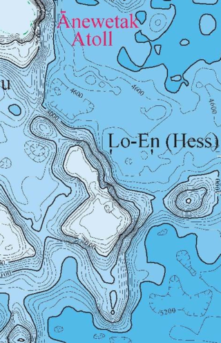
| Lo-En [6] | Hess [66] | Named after the hibiscus tree [8] | 10°06.00′N162°52.20′E / 10.10000°N 162.87000°E [66] | 113 million years [66] | |||
| Mij-Lep [6] | A gap between islands on Ujlan [8] | 8°48.60′N163°12.60′E / 8.81000°N 163.21000°E [67] | 1,105 metres (3,625 ft) [61] | 106 million years [67] | A number of pinnacles, including a flat topped one on the summit, cover Mij-Lep. [61] | ||
| Ļemkein [6] | 9°18′N166°05′E / 9.300°N 166.083°E [33] | ||||||
| Ļewōnjoui [6] | 10°32.31′N166°27.83′E / 10.53850°N 166.46383°E [68] | 2,985 metres (9,793 ft) [68] | 1,441 cubic kilometres (346 cu mi) [68] | ||||
| Ļōkkwōrkwōr [6] | Erikub [69] | 9°09.00′N170°00.00′E / 9.15000°N 170.00000°E [69] | 1,400 metres (4,600 ft) [26] | 87 million years [69] | Alkali basalts and hawaiite have been dredged, which contain clinopyroxene, olivine derivatives and plagioclase and show evidence of having been eroded above the water surface [27] | ||
| Litakpooki [6] | 8°18.60′N160°38.40′E / 8.31000°N 160.64000°E [70] | ||||||
| Ṃaanjidep [6] | A chief from Jalwoj [16] | 6°43.80′N169°19.80′E / 6.73000°N 169.33000°E [71] | 2,215 metres (7,267 ft) [61] | The depth probably does not refer to the actual summit. [61] | |||
| Ļoṃjenaelik [6] | A chief from Arno [16] | ||||||
| Ļōmōļkā [6] | A chief from Mile [16] | 6°37.80′N172°21.60′E / 6.63000°N 172.36000°E [72] | |||||
| Limalok [6] | Harrie [73] | A chiefess from Mile [16] | 5°36.00′N172°21.60′E / 5.60000°N 172.36000°E [73] | 68 million years [73] |