Related Research Articles
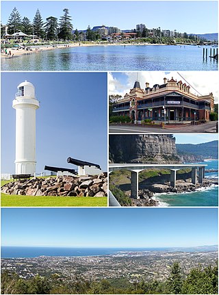
Wollongong, colloquially referred to as The Gong, is a city located in the Illawarra region of New South Wales, Australia. The name is believed to originate from the Dharawal language, meaning either 'five islands/clouds', 'ground near water' or 'sound of the sea'. Wollongong lies on the narrow coastal strip between the Illawarra Escarpment and the Pacific Ocean, 85 kilometres south of central Sydney. Wollongong had an estimated urban population of 302,739 at June 2018, making it the third-largest city in New South Wales after Sydney and Newcastle and the tenth-largest city in Australia by population. The city's current Lord Mayor is Gordon Bradbery AM who was elected in 2021.

Batemans Bay is a town on the South Coast region of the state of New South Wales, Australia. Batemans Bay is administered by the Eurobodalla Shire council. The town is situated on the shores of an estuary formed where the Clyde River meets the southern Pacific Ocean.

Port Kembla is a suburb of Wollongong 10 km south of the CBD and part of the Illawarra region of New South Wales. The suburb comprises a seaport, industrial complex, a small harbour foreshore nature reserve, and a small commercial sector. It is situated on the tip of Red Point: its first European sighting was by Captain James Cook in 1770. The name "Kembla" is an Aboriginal word meaning "plenty [of] wild fowl".

Tathra is a seaside town on the Sapphire Coast found on the South Coast, New South Wales, Australia. As at the 2016 census, Tathra had a population of 1,675.
The Clyde River is an open intermediate tide dominated drowned valley estuary, or perennial river that flows into the Tasman Sea at Batemans Bay, located in the South Coast region of New South Wales, Australia.

The Moruya River is an open and trained mature wave dominated barrier estuary or tidal river is located in the South Coast region of New South Wales, Australia. In its upper freshwater reaches, the river is known as the Deua River.

Huskisson is a town in New South Wales, Australia in the City of Shoalhaven, on the shores of Jervis Bay. It is 24 km south-east of Nowra.

Kiama is a heritage-listed intercity train station located in Kiama, New South Wales, Australia, on the South Coast railway line. The station serves NSW TrainLink diesel multiple unit trains traveling south to Bomaderry and electric multiple unit trains north to Wollongong and Sydney. Early morning and late night services to and from stations to the south are provided by train replacement bus services. It was added to the New South Wales State Heritage Register on 2 April 1999.

Albion Park railway station is a heritage-listed railway station located on the South Coast railway line on the Princes Highway in Albion Park Rail, New South Wales, Australia. The station was designed by New South Wales Government Railways and built during 1887 by William Monie & Company, with the single line railway line built by David Proudfoot and Thomas Logan. The complex is also known as the Albion Park Railway Station Group. The property was added to the New South Wales State Heritage Register on 2 April 1999. The station is located close to Shellharbour Airport.

Bermagui is a town on the south coast of New South Wales, Australia in the Bega Valley Shire. It lies on the shores of the southern end of Horseshoe Bay. The name is derived from the Dyirringanj word, permageua, possibly meaning "canoe with paddles".

Merimbula is a town on the Merimbula Lake, located on the Far South Coast or Sapphire Coast of New South Wales, Australia. At the 2016 census, the population was 3,544.

The Illawarra Steam Navigation Company was a shipping company that serviced the south coast of New South Wales, Australia from 1858 to the early 1950s. It was formed through the amalgamation of the General Steam Navigation Company, the Kiama Steam Navigation Company and the Shoalhaven Steam Navigation Company, each of whom serviced parts of the south coast with their respective vessels. After merging, the new company held a near monopoly in regard to shipping on the south coast, and their fleet visited every significant port between Sydney and the border of Victoria. The company transported both passengers and a range of produce, including livestock, and hence it became known as the 'Pig and Whistle Line': it was said that ships would wait an hour for a pig but not a minute for a passenger.

The South Coast refers to the narrow coastal belt from Shoalhaven district in the north to the border with Victoria in the south in the south-eastern part of the State of New South Wales, Australia. It is bordered to the west by the coastal escarpment of the Southern Tablelands, and is largely covered by a series of national parks, namely Jervis Bay National Park, Eurobodalla National Park, and Beowa National Park. To the east is the coastline of the Pacific Ocean, which is characterised by rolling farmlands, small towns and villages along a rocky coastline, interspersed by numerous beaches and lakes.
The Unanderra–Moss Vale railway line is a cross country railway line in New South Wales, Australia. The line branches from the Illawarra line at Unanderra and winds west up the Illawarra escarpment to join the Main South line at Moss Vale. The line is one of the most scenic in New South Wales, and for the first 20 km after leaving Unanderra has an almost continuous grade 1 in 30 providing extensive views over the Illawarra coastline.
The Port of Eden is a small seaport situated in Twofold Bay, adjacent to the town of Eden, located in the South Coast region of New South Wales, Australia.

Mort's Dock is a former dry dock, slipway, and shipyard in Balmain, New South Wales, Australia. It was the first dry dock in Australia, opening for business in 1855 and closing more than a century later in 1959. The site is now parkland.

Currarong is a small coastal fishing and tourist village of 556 houses in the Shoalhaven area of New South Wales, Australia. At the 2021 census, Currarong had a permanent population of 479. The village is a haven for fishermen, with several underwater rises where fish are abundant. As of 2021, there is a general store and take away cafe called Zac's Place, a licensed club, a caravan park, and many properties available for holiday rental.

The SS South Steyne is a former Manly ferry on Sydney Harbour. She was the world's largest steam-powered passenger ferry and operated on the service from 1938 to 1974. Restored in the 1980s, she served as a restaurant ship in Newcastle in the 1990s, and in 2000 was moved back to Sydney and open to the public at Darling Harbour. Since April 2016 she has been stored at Berrys Bay. She was added to the New South Wales State Heritage Register on 2 April 1999.

Port Kembla is a man-made cargo port or artificial harbour, with an outer harbour protected by breakwaters and an inner harbour constructed by dredging, located in the Illawarra region of New South Wales, Australia.

Wollongong Harbour Precinct is a heritage-listed shipping harbour at Cliff Road and Endeavour Drive, in Wollongong, New South Wales, Australia. It was built in 1837. The historic precinct includes Belmore Basin, Government Dam, Government Basin, Stockade Point, Flagstaff Hill, Signal Hill, Brighton Beach, Boat Harbour and Fortress Hill. It was added to the New South Wales State Heritage Register on 5 May 2010.
References
- ↑ "Bega". Maritime Heritage Online. NSW Department of Planning – Heritage Office. Retrieved 2 February 2009.
- ↑ "Benandra". Maritime Heritage Online. NSW Department of Planning – Heritage Office. Retrieved 2 February 2009.
- 1 2 Moore, Dennis (2002). "The Inlet That Eluded Bass, Batemans Bay - South Coast NSW". Morningside Internet. Archived from the original on 2013-04-10. Retrieved 2006-04-10.
- ↑ "Blackwall". Maritime Heritage Online. NSW Department of Planning – Heritage Office. Retrieved 2 February 2009.
- ↑ "Bodalla". Maritime Heritage Online. NSW Department of Planning – Heritage Office. Retrieved 2 February 2009.
- ↑ "Coolangatta". Maritime Heritage Online. NSW Department of Planning – Heritage Office. Retrieved 2 February 2009.
- 1 2 "Duroby". Maritime Heritage Online. NSW Department of Planning – Heritage Office. Retrieved 2 February 2009.
- ↑ Lorck, W. (1905). Illawarra and South Coast Steam Navigation Company's illustrated handbook: a guide for the tourist and holiday maker. Sydney: W. Lorck. National Library of Australia call number N 919.44 I29.
- ↑ "John Penn". Maritime Heritage Online. NSW Department of Planning – Heritage Office. Retrieved 2 February 2009.
- ↑ "Kameruka". Maritime Heritage Online. NSW Department of Planning – Heritage Office. Retrieved 2 February 2009.
- ↑ "Merimbula". Maritime Heritage Online. NSW Department of Planning – Heritage Office. Retrieved 2 February 2009.
- ↑ "Merimbula". Maritime Heritage Online. NSW Department of Planning – Heritage Office. Retrieved 2 February 2009.