Related Research Articles

The Basin and Range Province is a vast physiographic region covering much of the inland Western United States and northwestern Mexico. It is defined by unique basin and range topography, characterized by abrupt changes in elevation, alternating between narrow faulted mountain chains and flat arid valleys or basins. The physiography of the province is the result of tectonic extension that began around 17 million years ago in the early Miocene epoch.

The Niger Delta Basin, also referred to as the Niger Delta province, is an extensional rift basin located in the Niger Delta and the Gulf of Guinea on the passive continental margin near the western coast of Nigeria with suspected or proven access to Cameroon, Equatorial Guinea and São Tomé and Príncipe. This basin is very complex, and it carries high economic value as it contains a very productive petroleum system. The Niger delta basin is one of the largest subaerial basins in Africa. It has a subaerial area of about 75,000 km2, a total area of 300,000 km2, and a sediment fill of 500,000 km3. The sediment fill has a depth between 9–12 km. It is composed of several different geologic formations that indicate how this basin could have formed, as well as the regional and large scale tectonics of the area. The Niger Delta Basin is an extensional basin surrounded by many other basins in the area that all formed from similar processes. The Niger Delta Basin lies in the south westernmost part of a larger tectonic structure, the Benue Trough. The other side of the basin is bounded by the Cameroon Volcanic Line and the transform passive continental margin.

In geology, a rift is a linear zone where the lithosphere is being pulled apart and is an example of extensional tectonics. Typical rift features are a central linear downfaulted depression, called a graben, or more commonly a half-graben with normal faulting and rift-flank uplifts mainly on one side. Where rifts remain above sea level they form a rift valley, which may be filled by water forming a rift lake. The axis of the rift area may contain volcanic rocks, and active volcanism is a part of many, but not all, active rift systems.

The Los Angeles Basin is a sedimentary basin located in Southern California, in a region known as the Peninsular Ranges. The basin is also connected to an anomalous group of east-west trending chains of mountains collectively known as the Transverse Ranges. The present basin is a coastal lowland area, whose floor is marked by elongate low ridges and groups of hills that is located on the edge of the Pacific Plate. The Los Angeles Basin, along with the Santa Barbara Channel, the Ventura Basin, the San Fernando Valley, and the San Gabriel Basin, lies within the greater Southern California region. The majority of the jurisdictional land area of the city of Los Angeles physically lies within this basin.
The Hunter-Bowen Orogeny was a significant arc accretion event in the Permian and Triassic periods affecting approximately 2,500 km of the Australian continental margin.

The U.S. state of Georgia is commonly divided into four geologic regions that influence the location of the state's four traditional physiographic regions. The four geologic regions include the Appalachian foreland, Blue Ridge, Piedmont, and Coastal Plain. These four geologic regions commonly share names with and typically overlap the four physiographic regions of the state: the Appalachian Plateau and adjacent Valley and Ridge; the Blue Ridge; the Piedmont and the Coastal Plain.
The Lachlan Fold Belt (LFB) or Lachlan Orogen is a geological subdivision of the east part of Australia. It is a zone of folded and faulted rocks of similar age. It dominates New South Wales and Victoria, also extending into Tasmania, the Australian Capital Territory and Queensland. It was formed in the Middle Paleozoic from 450 to 340 Mya. It was earlier known as Lachlan Geosyncline. It covers an area of 200,000 km2.

The geology of Tasmania is complex, with the world's biggest exposure of diabase, or dolerite. The rock record contains representatives of each period of the Neoproterozoic, Paleozoic, Mesozoic and Cenozoic eras. It is one of the few southern hemisphere areas that were glaciated during the Pleistocene with glacial landforms in the higher parts. The west coast region hosts significant mineralisation and numerous active and historic mines.

The Coyote Mountains are a small mountain range in San Diego and Imperial Counties in southern California. The Coyotes form a narrow ESE trending 2 mi (3.2 km) wide range with a length of about 12 mi (19 km). The southeast end turns and forms a 2 mi (3.2 km) north trending "hook". The highest point is Carrizo Mountain on the northeast end with an elevation of 2,408 feet (734 m). Mine Peak at the northwest end of the range has an elevation of 1,850 ft (560 m). Coyote Wash along I-8 along the southeast margin of the range is 100 to 300 feet in elevation. Plaster City lies in the Yuha Desert about 5.5 mi (8.9 km) east of the east end of the range.
This is a list of articles related to plate tectonics and tectonic plates.

The geology of Massachusetts includes numerous units of volcanic, intrusive igneous, metamorphic and sedimentary rocks formed within the last 1.2 billion years. The oldest formations are gneiss rocks in the Berkshires, which were metamorphosed from older rocks during the Proterozoic Grenville orogeny as the proto-North American continent Laurentia collided against proto-South America. Throughout the Paleozoic, overlapping the rapid diversification of multi-cellular life, a series of six island arcs collided with the Laurentian continental margin. Also termed continental terranes, these sections of continental rock typically formed offshore or onshore of the proto-African continent Gondwana and in many cases had experienced volcanic events and faulting before joining the Laurentian continent. These sequential collisions metamorphosed new rocks from sediments, created uplands and faults and resulted in widespread volcanic activity. Simultaneously, the collisions raised the Appalachian Mountains to the height of the current day Himalayas.

The Benue Trough is a major geological structure underlying a large part of Nigeria and extending about 1,000 km northeast from the Bight of Benin to Lake Chad. It is part of the broader West and Central African Rift System.

The island of Taiwan was formed approximately 4 to 5 million years ago at a convergent boundary between the Philippine Sea Plate and the Eurasian Plate. In a boundary running the length of the island and continuing southwards, the Eurasian Plate is sliding under the Philippine Sea Plate. In the northeast of the island, the Philippine Sea Plate slides under the Eurasian Plate. Most of the island comprises a huge fault block tilted to the west.
The geology of Cameroon is almost universally Precambrian metamorphic and igneous basement rock, formed in the Archean as part of the Congo Craton and the Central African Mobile Zone and covered in laterite, recent sediments and soils. Some parts of the country have sequences of sedimentary rocks from the Paleozoic, Mesozoic and Cenozoic as well as volcanic rock produced by the 1600 kilometer Cameroon Volcanic Line, which includes the still-active Mount Cameroon. The country is notable for gold, diamonds and some onshore and offshore oil and gas.

The geology of Sudan formed primarily in the Precambrian, as igneous and metamorphic crystalline basement rock. Ancient terranes and inliers were intruded with granites, granitoids as well as volcanic rocks. Units of all types were deformed, reactivated, intruded and metamorphosed during the Proterozoic Pan-African orogeny. Dramatic sheet flow erosion prevented almost any sedimentary rocks from forming during the Paleozoic and Mesozoic. From the Mesozoic into the Cenozoic the formation of the Red Sea depression and complex faulting led to massive sediment deposition in some locations and regional volcanism. Sudan has petroleum, chromite, salt, gold, limestone and other natural resources.
The geology of South Korea includes rocks dating to the Archean and two large massifs of metamorphic rock as the crystalline basement, overlain by thick sedimentary sequences, younger metamorphic rocks and volcanic deposits. Despite the country's small size, its geology is diverse, containing rocks formed during the Precambrian to Cenozoic eras.
The geology of Greece is highly structurally complex due to its position at the junction between the European and African tectonic plates.

The subduction tectonics of the Philippines is the control of geology over the Philippine archipelago. The Philippine region is seismically active and has been progressively constructed by plates converging towards each other in multiple directions. The region is also known as the Philippine Mobile Belt due to its complex tectonic setting.
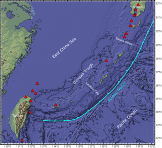
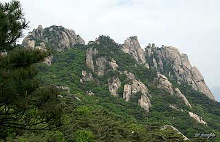
The Ryukyu Arc is an island arc which extends from the south of Kyushu along the Ryukyu Islands to the northeast of Taiwan, spanning about 1,200 kilometres (750 mi). It is located along a section of the convergent plate boundary where the Philippine Sea Plate is subducting northwestward beneath the Eurasian Plate along the Ryukyu Trench. The arc has an overall northeast to southwest trend and is located northwest of the Pacific Ocean and southeast of the East China Sea. It runs parallel to the Okinawa Trough, an active volcanic arc, and the Ryukyu Trench. The Ryukyu Arc, based on its geomorphology, can be segmented from north to south into Northern Ryukyu, Central Ryukyu, and Southern Ryukyu; the Tokara Strait separates Northern Ryukyu and Central Ryukyu at about 130˚E while the Kerama Gap separates Central Ryukyu and Southern Ryukyu at about 127 ˚E. The geological units of the arc include igneous, sedimentary, and metamorphic rocks, ranging from the Paleozoic to Cenozoic in age.

The San Diego Trough Fault Zone is a group of connected right-lateral strike-slip faults that run parallel to the coast of Southern California, United States, for 150–166 km (93–103 mi). The fault zone takes up 25% of the slip within the Inner Continental Borderlands. Portions of the fault get within 30 km (19 mi) of populated cities, however the faults never reach shore. The north of the fault zone begins where the San Pedro Basin Fault Zone and the Santa Catalina Fault Zone meet, and the southern section terminates where it reaches the Bahía Soledad Fault. Seismic risk along the fault is high, with potential earthquake scenarios reaching up to magnitude 7.9 in the worst case. An earthquake of this size would devastate coastal areas.
References
- ↑ U.S. Geological Survey Professional Paper. U.S. Government Printing Office. 1984. p. 1.