Route 495 is a 3.45-mile-long (5.55 km) state highway in Hudson County, New Jersey, in the United States that connects the New Jersey Turnpike at exits 16E-17 in Secaucus to New York State Route 495 (NY 495) inside the Lincoln Tunnel in Weehawken, providing access to Midtown Manhattan in New York City. The road is owned and operated by the New Jersey Turnpike Authority (NJTA) between the New Jersey Turnpike and Route 3, the New Jersey Department of Transportation (NJDOT) between Route 3 and Park Avenue near the Union City–Weehawken border, and by the Port Authority of New York and New Jersey (PANYNJ) east of Park Avenue, including the helix used to descend the New Jersey Palisades to reach the entrance of the Lincoln Tunnel. Route 495 is mostly a six-lane freeway with a reversible bus lane used during the morning rush hour. The bus lane, which runs the entire length of the freeway, continues into the Lincoln Tunnel's center tube.

North Bergen is a township in the northern part of Hudson County, in the U.S. state of New Jersey. As of the 2020 United States census, the township's population was 63,361, an increase of 2,588 (+4.3%) from the 2010 census count of 60,773, which in turn reflected an increase of 2,681 (+4.6%) from the 58,092 counted in the 2000 census. The township was incorporated in 1843. It was much diminished in territory by a series of secessions. Situated on the Hudson Palisades, it is one of the hilliest municipalities in the United States. Like neighboring North Hudson communities, North Bergen is among those places in the nation with the highest population density and a majority Hispanic population.

Weehawken is a township in the northern part of Hudson County, in the U.S. state of New Jersey. It is located on the Hudson Waterfront and Hudson Palisades overlooking the Hudson River. As of the 2020 United States census, the township's population was 17,197, an increase of 4,643 (+37.0%) from the 2010 census count of 12,554, which in turn reflected a decline of 947 (−7.0%) from the 13,501 counted in the 2000 census.
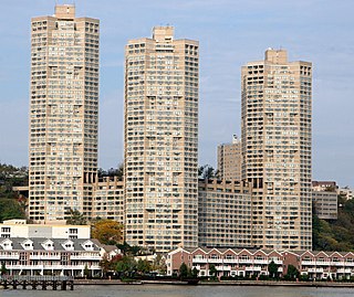
Galaxy Towers, also known as the Galaxy Towers Condominium Association or GTCA, are a trio of 415 feet (126 m) octagonal towers located at 7000 Kennedy Boulevard East in the southeastern corner of Guttenberg, New Jersey, United States, overlooking the Hudson River. The towers were built in 1976 by a partnership of Norman Belfer, a Long Island developer who owned another high-rise in Guttenberg, and the Prudential Insurance Company of America. It began as a rental apartment complex but was converted to condominiums in 1980. It contains a mixture of condominiums, retail, and office space, including 1,075 apartments. The brutalist-style complex was designed by Gruzen & Partners and developed by Prudential Insurance Company. As of the 2010 Census, one-fifth of Guttenberg's residents live in the Galaxy.
Paterson Plank Road is a road that runs through Passaic, Bergen and Hudson Counties in northeastern New Jersey. The route, originally laid in the colonial era, connects the city of Paterson and the Hudson River waterfront. It has largely been superseded by Route 3, but in the many towns it passes it has remained an important local thoroughfare, and in some cases been renamed.

Bergen Hill refers to the lower Hudson Palisades in New Jersey, where they emerge on Bergen Neck, which in turn is the peninsula between the Hackensack and Hudson Rivers, and their bays. In Hudson County, it reaches a height of 260 feet.

The Hudson River Waterfront Walkway, also known as the Hudson River Walkway, is a promenade along the Hudson Waterfront in New Jersey. The ongoing and incomplete project located on Kill van Kull and the western shore of Upper New York Bay and the Hudson River was implemented as part of a New Jersey state-mandated master plan to connect the municipalities from the Bayonne Bridge to the George Washington Bridge with an urban linear park and provide contiguous unhindered access to the water's edge.
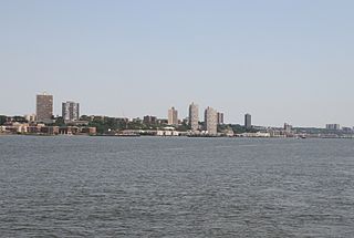
North Hudson is the area in the northern part of Hudson County, New Jersey, situated on the west bank of the Hudson River, mostly atop the Hudson Palisades. It comprises Weehawken, Union City, West New York, Guttenberg, and North Bergen.

Weehawken Terminal was the waterfront intermodal terminal on the North River in Weehawken, New Jersey for the New York Central Railroad's West Shore Railroad division, whose route traveled along the west shore of the Hudson River. It opened in 1884 and closed in 1959. The complex contained five ferry slips, sixteen passenger train tracks, car float facilities, and extensive yards. The facility was also used by the New York, Ontario and Western Railway. The terminal was one of five passenger railroad terminals that lined the Hudson Waterfront during the 19th and 20th centuries; the others were located at Hoboken, Pavonia, Exchange Place and Communipaw, with Hoboken being the only one still in use.
The James Monroe is a 312-foot-tall (95-m) residential skyscraper in the Newport neighborhood of Jersey City, New Jersey. It was completed in 1989 and has 34 floors and stands at a height of 312 feet. The 443-unit, 34-story residential condominium tower contains studio apartments, one and two bedroom units, and three bedroom duplexes. It was developed by the Lefrak Organization of Rego Park, Queens together with Melvin Simon & Associates of Indianapolis and the Glimcher Company of Columbus, Ohio.

The Hackensack Water Company Complex is a set of historic buildings in Weehawken, New Jersey, registered in the U.S. National Register of Historic Places. The Hackensack Water Company, a predecessor of Suez North America, developed water supply and storage in northeastern New Jersey from the 1870s to the 1970s, initially to provide service to the city of Hackensack and the towns of North Hudson. Originally its headquarters and major facilities were located at Hackensack, in Bergen County. Under Robert W. de Forest, who ran the Hackensack Water Company for 46 years beginning in 1881, the company constructed new facilities and moved its headquarters to Weehawken in Hudson County, setting up offices in a brick water tower, part of the present complex.
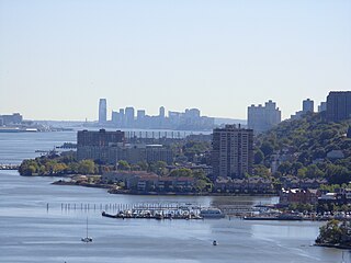
The Hudson Waterfront is an urban area of northeastern New Jersey along the lower reaches of the Hudson River, the Upper New York Bay and the Kill van Kull. Though the term can specifically mean the shoreline, it is often used to mean the contiguous urban area between the Bayonne Bridge and the George Washington Bridge that is approximately 19 miles (31 km) long. Historically, the region has been known as Bergen Neck, the lower peninsula, and Bergen Hill, lower Hudson Palisades. It has sometimes been called the Gold Coast.

Boulevard East is a two-way, mostly two lane, scenic county road in the North Hudson, New Jersey municipalities of Weehawken, West New York, Guttenberg and North Bergen. Apart from small sections at either end, the road runs along the crest of the Hudson Palisades, affording it views of the Hudson River and the New York City skyline. Developed at the turn of the 20th century, the residential road is characterized by an eclectic mix of 20th-century architecture, including private homes as well as mid and high-rise apartment buildings, mostly on its western side, with a promenade and parks along its eastern side. It is also the setting for Edward Hopper's 1934 painting East Wind Over Weehawken, which is considered one of his best works.

The North Hudson Railway Company built and operated a streetcar system in Hudson County and southeast Bergen County, New Jersey before and after the start of the 20th century. It was founded by Hillric J. Bonn who became the first President in 1865 and served for 26 years until his death, and eventually taken over by the Public Service Railway. In its endeavors to overcome the formidable obstacle of ascending the lower Hudson Palisades, or Bergen Hill, it devised numerous innovative engineering solutions including funicular wagon lifts, an inclined elevated railway, an elevator and viaducts.

Palisade Avenue is the name given to a historic road which parallels the eastern crest of Hudson Palisades in northeastern New Jersey. It travels between Jersey City and Fort Lee, passing through Jersey City Heights, North Hudson, and Cliffside Park, with various parts carrying Hudson and Bergen county route designations. The avenue re-aligns itself at several places along its route as it crosses traditional municipal boundaries created in the 19th century. As a primary route running along the top of the Hudson Palisades, many segments offer scenic views of the Hudson River and the New York skyline. Since 2020 there is proposed state legislation to restrict building heights that would rise above the cliffs or on the eastern side of Palisade along the entire corridor from Jersey City to Fort Lee.

The Modern is a residential skyscraper complex in Fort Lee, New Jersey near George Washington Bridge Plaza at the western end of the George Washington Bridge (GWB) on the Hudson Waterfront. Situated atop the Hudson Palisades, the twin towers provide panoramic views of the New York City skyline, the Hudson River, the GWB, and surrounding suburbs.

The Stonehenge is a residential apartment building on Boulevard East in the Woodcliff section of North Bergen, New Jersey in the United States. Situated adjacent to North Hudson Park, the building was constructed in 1967 during a high-rise building spree and at 369 feet (112 m) is among the tallest buildings in the area and once one of the tallest in the state. The 34-story building has 356 apartments and 5 levels of indoor parking.

The Lincoln Tunnel Helix, known commonly as The Helix or the Route 495 Helix, is an elevated spiral bridge freeway that carries New Jersey Route 495 to and from the Lincoln Tunnel in Weehawken, New Jersey. It is an oval-shaped 270-degree loop between the Palisades cliffs and the tunnel’s toll plaza. The structure, built in 1937, is owned, operated and maintained by the Port Authority of New York and New Jersey (PANYNJ).


