List of tallest structures in Norway

Last updated
Map all coordinates using: OpenStreetMap  
Download coordinates as: KML  ·  GPX

A list of the tallest structures in Norway. This list contains all types of structures.

NamePinnacle heightYearStructural typeLocationCoordinatesRemarks
Longwave transmitter Ingøy 360 m1,181 ft2000 Guyed mast Ingøya, Finnmark 71°4′17″N24°5′14″E / 71.07139°N 24.08722°E / 71.07139; 24.08722 (Ingøy longwave transmitter) Tallest structure in Scandinavia
Hovdefjell transmitter 250 m820 ft?guyed mast Myra 58°42′12.62″N8°39′30.21″E / 58.7035056°N 8.6583917°E / 58.7035056; 8.6583917 (Hovdefjell transmitter)
Vigra transmitter 243 m797 ft1953 Guyed mast Vigra, Møre og Romsdal 62°32′26″N6°2′52″E / 62.54056°N 6.04778°E / 62.54056; 6.04778 (Vigra transmitter) Height was reduced to 232 metres in 1999. Demolished 2011.
Hamnefjell transmitter 241 m791 ft?guyed mast Batsfjord 70°40′12.26″N29°42′37.67″E / 70.6700722°N 29.7104639°E / 70.6700722; 29.7104639 (Hovdefjell transmitter)
Høiåsmasten 231 m758 ft1980Partially guyed tower Halden, Østfold 59°10′31″N11°25′43″E / 59.17528°N 11.42861°E / 59.17528; 11.42861 (Høiåsmasten) Height above ground is 758 feet (231 m) according to official VFR chart of Southern Norway.
Kløfta transmitter 230 m755 ft1954 Guyed mast Kløfta, Akershus 60°3′16″N11°9′39″E / 60.05444°N 11.16083°E / 60.05444; 11.16083 (Kløfta transmitter) Longwave transmitter on 216 kHz, shutdown in 1995, dismantled (when?)
Værlandet LORAN-C transmitter 220 m722 ft Guyed mast Værlandet, Sogn og Fjordane 61°17′50″N4°41′47″E / 61.29722°N 4.69639°E / 61.29722; 4.69639 (Værlandet LORAN-C transmitter) Insulated against ground
Berlevåg LORAN-C transmitter 219 m719 ft Guyed mast Berlevåg, Finnmark 70°50′43″N29°12′17″E / 70.84528°N 29.20472°E / 70.84528; 29.20472 (Berlevåg LORAN-C transmitter) Insulated against ground
Greipstad transmitter 218 m715 ft1958 Partially guyed tower Greipstad, Vest-Agder 58°13′8″N7°51′6″E / 58.21889°N 7.85167°E / 58.21889; 7.85167 (Greipstad transmitter)
Tryvannshøyden TV Mast209 m686 ftGuyed mast Oslo 59°59′5.87″N10°40′11.8″E / 59.9849639°N 10.669944°E / 59.9849639; 10.669944 (Tryvannshøyden TV Mast) close to Tryvannstårnet. Height above ground is 686 ft according to Norway VFR chart.
Gossen transmitter 200 m656 ft?guyed mast Gossa 62°47′08.97″N6°54′05.01″E / 62.7858250°N 6.9013917°E / 62.7858250; 6.9013917 (Gossen transmitter) LF-transmitter, insulated against ground
Vassfjellet transmitter, large mast200 m660 ft2001 Guyed mast Melhus/Klæbu, Sør-Trøndelag 63°15′39.27″N10°21′27.73″E / 63.2609083°N 10.3577028°E / 63.2609083; 10.3577028 (Vassfjellet transmitter, large mast) On the summit of Vassfjellet
Bø LORAN-C transmitter 192 m630 ft Guyed mast , Nordland 68°38′6″N14°27′47″E / 68.63500°N 14.46306°E / 68.63500; 14.46306 (Bø LORAN-C transmitter) Insulated against ground
LORAN-C transmitter Jan Mayen 190 m623 ft Guyed mast Jan Mayen, Arctic Ocean 70°54′51.478″N8°43′56.53″W / 70.91429944°N 8.7323694°W / 70.91429944; -8.7323694 (Jan Mayen LORAN-C transmitter) Insulated against ground, built as replacement of 190.5 metre tower collapsed in 1980 as result of icing.
Nordhue transmitter 182 m597 ft Partially guyed tower Elverum, Hedmark 60°59′38″N11°20′16″E / 60.99389°N 11.33778°E / 60.99389; 11.33778 (Nordhue transmitter) lattice tower as basement
Bokn transmitter168 m551 ftGuyed mast Bokn 59°13′12.79″N5°25′42.37″E / 59.2202194°N 5.4284361°E / 59.2202194; 5.4284361 (Bokn transmitter)
Grenland Bridge 166 m545 ft1996 Bridge Porsgrunn, Telemark 59°3′10″N9°40′33″E / 59.05278°N 9.67583°E / 59.05278; 9.67583 (Grenland Bridge)
Skavlen transmitter 165 m541 ft1975 Guyed mast Mosvik, Nord-Trøndelag 63°46′19″N10°57′4″E / 63.77194°N 10.95111°E / 63.77194; 10.95111 (Skavlen transmitter)
Kongsvinger transmitter163 m535 ftGuyed mastKongsvinger 60°10′4″N11°59′38″E / 60.16778°N 11.99389°E / 60.16778; 11.99389 (Kongsvinger transmitter)
Vealøs TV Tower163 m535 ftTowerSkien 59°14′9.48″N9°41′57.24″E / 59.2359667°N 9.6992333°E / 59.2359667; 9.6992333 (Vealøs TV Tower) Tallest completely free-standing radio tower in Norway
Lyngdal transmitter 156 m512 ft1954 Partially guyed tower Lyngdal, Vest-Agder 58°11′33″N6°55′57″E / 58.19250°N 6.93250°E / 58.19250; 6.93250 (Lyngdal transmitter)
Gamlemsveten transmitter 154 m505 ft? Partially guyed tower Haram 62°34′29.53″N6°19′6.37″E / 62.5748694°N 6.3184361°E / 62.5748694; 6.3184361 (Gamlemsveten transmitter)
Skarnsund Bridge 152 m499 ft1991 Bridge Mosvik, Nord-Trøndelag 63°50′35.42″N11°4′31.54″E / 63.8431722°N 11.0754278°E / 63.8431722; 11.0754278 (Skarnsund Bridge)
Askøy Bridge 152 m499 ft1992 Bridge Bergen/Askøy, Hordaland 60°23′46″N5°12′51″E / 60.39611°N 5.21417°E / 60.39611; 5.21417 (Askøy Bridge)
Storøy Vindpark150 m492 ft2018Windmill Karmøy, Rogaland 59°24′56″N5°13′37″E / 59.41556°N 5.22694°E / 59.41556; 5.22694 (Storøy Vindpark)
Steinfjellet transmitter 148 m486 ft?Partially guyed towerBremanger 61°52′31″N4°59′23″E / 61.87528°N 4.98972°E / 61.87528; 4.98972 (Steinfjellet transmitter)
Old chimney of Sarpsborg Borregaard Works147 m482 ft1976 Chimney Sarpsborg 59°16′36.09″N11°7′39.19″E / 59.2766917°N 11.1275528°E / 59.2766917; 11.1275528 (Old chimney of Sarpsborg Borregaard Works) demolished in 2008
Karmsundet Powerline Crossing 143.5 m471 ft Electricity pylon Karmsund, Rogaland 59°19′7″N5°19′11″E / 59.31861°N 5.31972°E / 59.31861; 5.31972 (Karmsundet Powerline Crossing, Tower Northwest) ; 59°19′3″N5°19′11″E / 59.31750°N 5.31972°E / 59.31750; 5.31972 (Karmsundet Powerline Crossing, Tower West) ; 59°19′0″N5°19′10″E / 59.31667°N 5.31944°E / 59.31667; 5.31944 (Karmsundet Powerline Crossing, Tower Southwest) ; 59°19′6″N5°20′17″E / 59.31833°N 5.33806°E / 59.31833; 5.33806 (Karmsundet Powerline Crossing, Tower Northeast) ; 59°19′1″N5°20′9″E / 59.31694°N 5.33583°E / 59.31694; 5.33583 (Karmsundet Powerline Crossing, Tower East) ; 59°18′56″N5°20′5″E / 59.31556°N 5.33472°E / 59.31556; 5.33472 (Karmsundet Powerline Crossing, Tower Southeast) 6 pylons
Bagn transmitter140 m459 ftConcrete TowerBagn 60°48′32″N9°37′0″E / 60.80889°N 9.61667°E / 60.80889; 9.61667 (Bagn transmitter)
Kattnakken transmitter140 m460 ftConcrete TowerLeirvik 59°52′26″N5°29′36″E / 59.87389°N 5.49333°E / 59.87389; 5.49333 (Kattnakken transmitter)
Helgeland Bridge 140 m459 ft1991 Bridge Sandnessjøen, Nordland 66°2′10″N12°42′30″E / 66.03611°N 12.70833°E / 66.03611; 12.70833 (Helgeland Bridge)
Sotra Decca Transmitter 136 m446 ft Guyed mast Ågotnes, Fjell, Hordaland 60°24′24″N5°00′34″E / 60.40667°N 5.00944°E / 60.40667; 5.00944 (Sotra Decca Transmitter ( demolished)) Insulated against ground, demolished
Hodne Decca Transmitter 136 m446 ft Guyed mast Hodne, Stavanger, Rogaland 58°47′15″N5°32′42″E / 58.78750°N 5.54500°E / 58.78750; 5.54500 (Hodne Decca Transmitter ( demolished)) Insulated against ground, demolished 22 January 1997. [1]
Geitfjellet transmitter 131 m430 ft1962 Partially guyed tower Grong, Nord-Trøndelag 64°24′51″N12°12′45″E / 64.41417°N 12.21250°E / 64.41417; 12.21250 (Geitfjellet transmitter)
Lakssvelafjellet transmitter 130 m427 ft?Partially guyed towerBjerkreim 58°37′59″N5°57′17″E / 58.63306°N 5.95472°E / 58.63306; 5.95472 (Lakssvelafjellet transmitter)
New chimney of Sarpsborg Borregaard Works130 m427 ft Chimney Sarpsborg
Tyholttårnet 124 m407 ft TV tower Trondheim, Sør-Trøndelag 63°25′21″N10°25′55″E / 63.42250°N 10.43194°E / 63.42250; 10.43194 (Tyholttårnet) Tallest observation tower in Norway (revolving restaurant included in tower)
Sognal transmitter124 m407 ftConcrete TowerKaupanger 61°10′23.39″N7°7′13.12″E / 61.1731639°N 7.1203111°E / 61.1731639; 7.1203111 (Sognal transmitter) ; 61°10′24.4″N7°7′11.49″E / 61.173444°N 7.1198583°E / 61.173444; 7.1198583 (Sognal transmitter)
Stad Decca Transmitter, Site North122 m400 ft Guyed mast Stad, Selje, Sogn og Fjordane 62°11′35″N5°07′31″E / 62.19306°N 5.12528°E / 62.19306; 5.12528 (Stad Decca Transmitter, North Site) Insulated against ground, today mobile phone mast
Stad Decca Transmitter, Site South122 m400 ft Guyed mast Stad, Selje, Sogn og Fjordane 62°11′15″N5°07′46″E / 62.18750°N 5.12944°E / 62.18750; 5.12944 (Stad Decca Transmitter, South Site ( demolished)) Insulated against ground, demolished
Gullsvagfjellet transmitter120 m394 ftConcrete TowerGladstad 65°39′25″N11°49′41″E / 65.65694°N 11.82806°E / 65.65694; 11.82806 (Gullsvagfjellet transmitter)
Tryvannstårnet 118 m387 ft1962 TV tower Oslo 59°59′19.08″N10°40′5.06″E / 59.9886333°N 10.6680722°E / 59.9886333; 10.6680722 (Tryvannstårnet)
Kvitsøy Tower 117.5 m385 ft1982Tower Kvitsøy, Rogaland 59°3′21″N5°26′14″E / 59.05583°N 5.43722°E / 59.05583; 5.43722 (Kvitsøy Tower) Grounded tower with cage antenna for MF-broadcasting
Oslo Plaza 117 m384 ft1991 High-rise Oslo 59°54′44.1″N10°45′18.9″E / 59.912250°N 10.755250°E / 59.912250; 10.755250 (Oslo Plaza) Oslo PlazaTallest high-rise building in Norway
Postgirobygget 110 m361 ft1975 High-rise Oslo 59°54′41″N10°45′16″E / 59.91139°N 10.75444°E / 59.91139; 10.75444 (Postgirobygget) Seven floors were added to the top of this building in 2003
Gjemnessund Bridge 108 m354 ft1992 Bridge Gjemnes, Møre og Romsdal 62°58′12″N7°46′40″E / 62.97000°N 7.77778°E / 62.97000; 7.77778 (Gjemnessund Bridge)
Vassfjellet transmitter, small mast107 m351 ft Guyed mast Melhus/Klæbu, Sør-Trøndelag 63°15′39.48″N10°21′27.27″E / 63.2609667°N 10.3575750°E / 63.2609667; 10.3575750 (Vassfjellet transmitter) On the summit of Vassfjellet
Gulen transmitter107 m351 ftConcrete TowerLindes 61°2′2″N5°9′13″E / 61.03389°N 5.15361°E / 61.03389; 5.15361 (Gulen transmitter)
Kongsberg transmitter103 m338 ftConcrete TowerKongsberg 59°40′15″N9°31′19″E / 59.67083°N 9.52194°E / 59.67083; 9.52194 (Kongsberg transmitter)
Reinsfjell transmitter103 m338 ftConcrete TowerKvalveg 62°55′50.2″N7°55′38.44″E / 62.930611°N 7.9273444°E / 62.930611; 7.9273444 (Reinsfjell transmitter) ; 62°55′51.33″N7°55′39.21″E / 62.9309250°N 7.9275583°E / 62.9309250; 7.9275583 (Reinsfjell transmitter)
Nidarosdomen 98 m322 ft1090 Cathedral Trondheim, Sør-Trøndelag 63°25′37″N10°23′49″E / 63.42694°N 10.39694°E / 63.42694; 10.39694 (Nidarosdomen)
Stord Bridge 97 m318 ft2000 Bridge Stord, Vestland 59°44′51″N5°24′10″E / 59.74750°N 5.40278°E / 59.74750; 5.40278 (Stord Bridge)
Jetta transmitterConcrete TowerLalm 61°53′52″N9°17′0″E / 61.89778°N 9.28333°E / 61.89778; 9.28333 (Jetta transmitter)
Tron transmitterConcrete TowerTron 62°10′26″N10°41′44″E / 62.17389°N 10.69556°E / 62.17389; 10.69556 (Tron transmitter)
Hol transmitterGuyed mastAl 60°33′32″N8°24′12″E / 60.55889°N 8.40333°E / 60.55889; 8.40333 (Hol transmitter)
Lonahorgi transmitterConcrete TowerSkulestadmoen 60°41′38.62″N6°24′51.73″E / 60.6940611°N 6.4143694°E / 60.6940611; 6.4143694 (Lonahorgi transmitter)
Nordfjordeid transmitterConcrete TowerNordfjordeid 61°53′24.59″N6°6′32.2″E / 61.8901639°N 6.108944°E / 61.8901639; 6.108944 (Nordfjordeid transmitter)
Ulriken Tower1959Concrete TowerBergen 60°22′37.82″N5°22′52.91″E / 60.3771722°N 5.3813639°E / 60.3771722; 5.3813639 (Ulriken Tower)


Related Research Articles

Data structure Particular way of storing and organizing data in a computer

In computer science, a data structure is a data organization, management, and storage format that enables efficient access and modification. More precisely, a data structure is a collection of data values, the relationships among them, and the functions or operations that can be applied to the data.

Graph theory Area of discrete mathematics

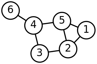
In mathematics, graph theory is the study of graphs, which are mathematical structures used to model pairwise relations between objects. A graph in this context is made up of vertices which are connected by edges. A distinction is made between undirected graphs, where edges link two vertices symmetrically, and directed graphs, where edges link two vertices asymmetrically; see Graph for more detailed definitions and for other variations in the types of graph that are commonly considered. Graphs are one of the prime objects of study in discrete mathematics.

Lisp (programming language) Programming language family

Lisp is a family of programming languages with a long history and a distinctive, fully parenthesized prefix notation. Originally specified in 1958, Lisp is the second-oldest high-level programming language in widespread use today. Only Fortran is older, by one year. Lisp has changed since its early days, and many dialects have existed over its history. Today, the best-known general-purpose Lisp dialects are Racket, Common Lisp, Scheme and Clojure.

In computer science, a linked list is a linear collection of data elements whose order is not given by their physical placement in memory. Instead, each element points to the next. It is a data structure consisting of a collection of nodes which together represent a sequence. In its most basic form, each node contains: data, and a reference to the next node in the sequence. This structure allows for efficient insertion or removal of elements from any position in the sequence during iteration. More complex variants add additional links, allowing more efficient insertion or removal of nodes at arbitrary positions. A drawback of linked lists is that access time is linear. Faster access, such as random access, is not feasible. Arrays have better cache locality compared to linked lists.

In linguistics, syntax is the set of rules, principles, and processes that govern the structure of sentences in a given language, usually including word order. The term syntax is also used to refer to the study of such principles and processes. The goal of many syntacticians is to discover the syntactic rules common to all languages.

Tree (data structure) Abstract data type simulating a hierarchical tree structure and represented as a set of linked nodes

In computer science, a tree is a widely used abstract data type that simulates a hierarchical tree structure, with a root value and subtrees of children with a parent node, represented as a set of linked nodes.

Extensible Markup Language (XML) is a markup language that defines a set of rules for encoding documents in a format that is both human-readable and machine-readable. The World Wide Web Consortium's XML 1.0 Specification of 1998 and several other related specifications—all of them free open standards—define XML.

National Register of Historic Places Federal list of historic sites in the United States

The National Register of Historic Places (NRHP) is the United States federal government's official list of districts, sites, buildings, structures and objects deemed worthy of preservation for their historical significance. A property listed in the National Register, or located within a National Register Historic District, may qualify for tax incentives derived from the total value of expenses incurred in preserving the property.

Organization Social entity established to meet needs or pursue goals

An organization, or organisation, is an entity – such as a company, an institution, or an association – comprising one or more people and having a particular purpose.

Listed building Protected historic structure in the United Kingdom

A listed building, or listed structure, is one that has been placed on one of the four statutory lists maintained by Historic England in England, Historic Environment Scotland in Scotland, Cadw in Wales, and the Northern Ireland Environment Agency in Northern Ireland.

Astronomical object Large natural physical entity in space

In astronomy, an astronomical object or celestial object is a naturally occurring physical entity, association, or structure that exists in the observable universe. In astronomy, the terms object and body are often used interchangeably. However, an astronomical body or celestial body is a single, tightly bound, contiguous entity, while an astronomical or celestial object is a complex, less cohesively bound structure, which may consist of multiple bodies or even other objects with substructures.

This is a list of lists of buildings and nonbuilding structures.

Cubic crystal system

In crystallography, the cubiccrystal system is a crystal system where the unit cell is in the shape of a cube. This is one of the most common and simplest shapes found in crystals and minerals.

Egyptian pyramids Ancient pyramid-shaped masonry structures located in Egypt

The Egyptian pyramids are ancient pyramid-shaped masonry structures located in Egypt. As of November 2008, sources cite either 118 or 138 as the number of identified Egyptian pyramids. Most were built as tombs for the country's pharaohs and their consorts during the Old and Middle Kingdom periods.

National Register of Historic Places property types

The U.S. National Register of Historic Places (NRHP) classifies its listings by various types of properties. Listed properties generally fall into one of five categories, though there are special considerations for other types of properties which do not fit into these five broad categories or fit into more specialized subcategories. The five general categories for NRHP properties are: building, district, object, site, and structure.

References