 |
|---|
Tehsils are third-order administrative divisions of Azad Kashmir, after divisions and districts. Tehsils are divided into fourth-order administrative divisions known as union councils. The following is a list of all of the tehsils of Azad Kashmir.
 |
|---|
Tehsils are third-order administrative divisions of Azad Kashmir, after divisions and districts. Tehsils are divided into fourth-order administrative divisions known as union councils. The following is a list of all of the tehsils of Azad Kashmir.

The administrative units of Pakistan comprise four provinces, one federal territory, and two disputed territories: the provinces of Punjab, Sindh, Khyber Pakhtunkhwa, and Balochistan; the Islamabad Capital Territory; and the administrative territories of Azad Jammu and Kashmir and Gilgit–Baltistan. As part of the Kashmir conflict with neighbouring India, Pakistan has also claimed sovereignty over the Indian-controlled territories of Jammu and Kashmir and Ladakh since the First Kashmir War of 1947–1948, but has never exercised administrative authority over either region. All of Pakistan's provinces and territories are subdivided into divisions, which are further subdivided into districts, and then tehsils, which are again further subdivided into union councils.

The Districts of Pakistan ; are the third-order administrative divisions of Pakistan, below provinces and divisions, but forming the first-tier of local government. In total, there are 160 districts in Pakistan including the Capital Territory and the districts of Azad Kashmir and Gilgit Baltistan. These districts are further divided into Tehsils, Union Councils.

Mansehra District is a district in Hazara Division of Khyber Pakhtunkhwa province in Pakistan. It is main gateway to upper valleys of Kaghan, Naran and also to Gilgit-Baltistan and Azad Kashmir.

Muzaffarabad is the capital and largest city of Azad Kashmir, and the 60th largest in Pakistan.

The Bhimber District is the southernmost district of the 10 districts of Pakistan's dependent territory of Azad Kashmir. It has an area of 1516 km², and the district headquarter is the town of Bhimber.

The Kotli District is one of the 10 districts of Pakistan's dependent territory of Azad Kashmir. It is bounded on the north by the Sudhanoti District and the Poonch District, on the north-east by the Poonch District of Indian-administered Jammu and Kashmir, on the south by the Mirpur District and the Bhimber District, and on the west by the Rawalpindi District on Pakistan's Punjab Province. It is the biggest district of Azad Kashmir by population and the second biggest by land area, after the Neelum District. The district headquarters is the city of Kotli.

The Muzaffarabad District is one of the 10 districts of Pakistan's dependent territory of Azad Kashmir. The district is located on the banks of the Jhelum and Neelum rivers and is very hilly. The total area of the Muzaffarabad District is 1,642 square kilometres (634 sq mi). The district is part of the Muzaffarabad Division, and the city of Muzaffarabad serves as the capital of Azad Kashmir. The district is bounded on the north-east by the Neelum District and the Kupwara District of Indian-administered Jammu and Kashmir, on the south-east by the Hattian Bala District, on the south by the Bagh District, and on the west by the Mansehra District and the Abbottabad District of Pakistan's Khyber Pakhtunkhwa Province.

The Poonch District is one of the 10 districts of Pakistan's dependent territory of Azad Kashmir. The Poonch District is bounded on the north by the Bagh District, on the north-east by the Haveli District, on the south-east by the Poonch District of Indian-administered Jammu and Kashmir, on the south by the Sudhanoti District and the Kotli District, and on the west by the Rawalpindi District of Pakistan's Punjab Province. The Poonch District is part of the greater Kashmir dispute between India and Pakistan. The district headquarters is the city of Rawalakot. It is the 3rd most populus district of Azad Kashmir.

The Mirpur District is one of the 10 districts of Pakistan's dependent territory of Azad Kashmir. The Mirpur District is bounded on the north by the Kotli District, on the east by the Bhimber District, on the south by the Gujrat District of Pakistan's Punjab Province, on the south-west by the Jhelum District of Pakistan's Punjab Province, and on the west by Rawalpindi District of Pakistan's Punjab Province. The district is named after its main city, Mirpur. The Mirpur District has a population of 456,200 and covers an area of 1,010 km2 (390 sq mi). The district is mainly mountainous with some plains. The Mirpur District has a humid subtropical climate which closely resembles that of the Gujrat District and the Jhelum District, the adjoining districts of Pakistan's Punjab Province.
Sehnsa Tehsil is a large Tehsil in Pakistan Administered Azad Kashmir which lies on the west of Gulpur on the Kotli-Rawalpindi road. Sehnsa is a sub-divisional (Tehsil) headquarters of Kotli district in the center of Sehnsa valley.
Pallandri, also spelled Palandri, originally Pulandari, is a Tehsil which serves as administrative capital of Sudhanoti district of Azad Kashmir. It is located at latitude 33° 42′ 54″ N, longitude 73° 41′ 9″ E, 90 km (56 mi) from Islamabad, the capital of Pakistan. It is connected with Rawalpindi and Islamabad through Azad Pattan road. The main tribe of Pallandri is the Sudhan tribe.

Pakistan is a federal republic with three tiers of government: national, provincial and local. Local government is protected by the constitution in Articles 32 and 140-A, and each province also has its own local-government-enabling legislation and ministries responsible for implementation. District councils and metropolitan corporations are respectively the highest rural and urban tiers of local government in the provinces. Both urban and rural local government have two or three tiers in all provinces except Khyber Pakhtunkhwa, where councils are not identified as either urban or rural. There are 129 district councils across the four provinces, 619 urban councils made up of one city district, four metropolitan corporations, 13 municipal corporations, 96 municipal committees, 148 town councils, 360 urban union committees, and 1,925 rural councils. Additionally there are 3339 neighbourhood, ‘tehsil’ and village councils in Khyber Pakhtunkhwa.
Mirpur may refer to several places:
Mirpur Tehsil is an administrative subdivision (tehsil) of Mirpur District, Azad Kashmir, Pakistan.
A zilā or zilla or zillah or jela or jilha is a country subdivision in Bangladesh, India, Nepal and Pakistan. It is translated as district.

The Hattian Bala District is one of the ten districts of Azad Kashmir, Pakistan. The district's headquarters is the town of Hattian Bala. Prior to 2009, the Hattian Bala District was a tehsil within Muzaffarabad District.

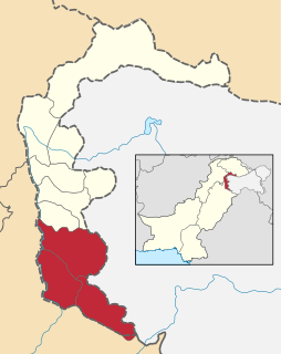
The Mirpur Division is a first-order administrative division of the Pakistani dependent territory of Azad Kashmir. Mirpur is the largest division by population in Azad Kashmir. It comprises the portion of the former Mirpur District of the princely state of Jammu and Kashmir that came under Pakistani control at the end of the Indo-Pakistani War of 1947.

Bhalessa is a geographical area in the Doda district of the Jammu region in Jammu and Kashmir. It consists of the Bunjwah and Bhalessa Valleys, and comprises the three Tehsils of Kahara, Chilly Pingal and Gandoh.