
Mount Shasta is a potentially active volcano at the southern end of the Cascade Range in Siskiyou County, California. At an elevation of 14,179 feet, it is the second-highest peak in the Cascades and the fifth-highest in the state. Mount Shasta has an estimated volume of 85 cubic miles, which makes it the most voluminous stratovolcano in the Cascade Volcanic Arc. The mountain and surrounding area are part of the Shasta–Trinity National Forest.

Mount Pelée or Mont Pelée is an active volcano at the northern end of Martinique, an island and French overseas department in the Lesser Antilles Volcanic Arc of the Caribbean. Its volcanic cone is composed of stratified layers of hardened ash and solidified lava. Its most recent eruption was in 1932.
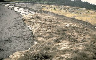
A lahar is a violent type of mudflow or debris flow composed of a slurry of pyroclastic material, rocky debris and water. The material flows down from a volcano, typically along a river valley.

Nevado del Ruiz, also known as La Mesa de Herveo is a volcano on the border of the departments of Caldas and Tolima in Colombia, about 129 km (80 mi) west of the capital city Bogotá. It is a stratovolcano composed of many layers of lava alternating with hardened volcanic ash and other pyroclastic rocks. Volcanic activity at Nevado del Ruiz began about two million years ago, during the Early Pleistocene or Late Pliocene, with three major eruptive periods. The current volcanic cone formed during the present eruptive period, which began 150,000 years ago.

Haleakalā, or the East Maui Volcano, is a massive, active shield volcano that forms more than 75% of the Hawaiian Island of Maui. The western 25% of the island is formed by another volcano, Mauna Kahalawai, also referred to as the West Maui Mountains.

David Alexander Johnston was an American United States Geological Survey (USGS) volcanologist who was killed by the 1980 eruption of Mount St. Helens in the U.S. state of Washington. A principal scientist on the USGS monitoring team, Johnston was killed in the eruption while manning an observation post six miles (10 km) away on the morning of May 18, 1980. He was the first to report the eruption, transmitting "Vancouver! Vancouver! This is it!" before he was swept away by a lateral blast; despite a thorough search, Johnston's body was never found, but state highway workers discovered remnants of his USGS trailer in 1993.

In volcanology, a lava dome is a circular, mound-shaped protrusion resulting from the slow extrusion of viscous lava from a volcano. Dome-building eruptions are common, particularly in convergent plate boundary settings. Around 6% of eruptions on Earth form lava domes. The geochemistry of lava domes can vary from basalt to rhyolite although the majority are of intermediate composition The characteristic dome shape is attributed to high viscosity that prevents the lava from flowing very far. This high viscosity can be obtained in two ways: by high levels of silica in the magma, or by degassing of fluid magma. Since viscous basaltic and andesitic domes weather fast and easily break apart by further input of fluid lava, most of the preserved domes have high silica content and consist of rhyolite or dacite.

Mount Rinjani is an active volcano in Indonesia on the island of Lombok. Administratively the mountain is in the Regency of North Lombok, West Nusa Tenggara. It rises to 3,726 metres (12,224 ft), making it the second highest volcano in Indonesia. It is also the highest point in the Indonesian province of West Nusa Tenggara.

A volcanic bomb or lava bomb is a mass of partially molten rock (tephra) larger than 64 mm (2.5 inches) in diameter, formed when a volcano ejects viscous fragments of lava during an eruption. Because volcanic bombs cool after they leave the volcano, they are extrusive igneous rocks. Volcanic bombs can be thrown many kilometres from an erupting vent, and often acquire aerodynamic shapes during their flight. Bombs can be extremely large; the 1935 eruption of Mount Asama in Japan expelled bombs measuring 5–6 m in diameter up to 600 m (2,000 ft) from the vent. Volcanic bombs are a significant volcanic hazard, and can cause severe injuries and death to people in an eruption zone. One such incident occurred at Galeras volcano in Colombia in 1993; six people near the summit were killed and several seriously injured by lava bombs when the volcano erupted unexpectedly. On July 16, 2018, 23 people were injured on a tour boat near the Kilauea volcano as a result of a basketball-sized lava bomb from the 2018 lower Puna eruption.

An effusive eruption is a type of volcanic eruption in which lava steadily flows out of a volcano onto the ground.

The Silverthrone Caldera is a potentially active caldera complex in southwestern British Columbia, Canada, located over 350 kilometres (220 mi) northwest of the city of Vancouver and about 50 kilometres (31 mi) west of Mount Waddington in the Pacific Ranges of the Coast Mountains. The caldera is one of the largest of the few calderas in western Canada, measuring about 30 kilometres (19 mi) long (north-south) and 20 kilometres (12 mi) wide (east-west). Mount Silverthrone, an eroded lava dome on the caldera's northern flank that is 2,864 metres (9,396 ft) high, may be the highest volcano in Canada.

The Wells Gray-Clearwater volcanic field, also called the Clearwater Cone Group, is a potentially active monogenetic volcanic field in east-central British Columbia, Canada, located approximately 130 km (81 mi) north of Kamloops. It is situated in the Cariboo Mountains of the Columbia Mountains and on the Quesnel and Shuswap Highlands. As a monogenetic volcanic field, it is a place with numerous small basaltic volcanoes and extensive lava flows.

The Smithsonian Institution's Global Volcanism Program (GVP) documents Earth's volcanoes and their eruptive history over the past 10,000 years. The mission of the GVP is to document, understand, and disseminate information about global volcanic activity.
The Mount Rainier Volcano Lahar Warning System consists of two separate components, operating in tandem: Acoustic Flow Monitors (AFM) and the All Hazard Alert Broadcast (AHAB) sirens. The AFM system was developed by the United States Geological Survey (USGS) in 1998 and is now maintained by Pierce County Emergency Management. The purpose of the warning system is to assist in the evacuation of residents in the river valleys around Mount Rainier, a volcano in Washington, in the event of a lahar. Pierce County works in partnership with the USGS, the Pacific Northwest Seismic Network (PNSN), Washington Military Department's Emergency Management Division, and South Sound 9-1-1 to monitor and operate the system.

A volcanic hazard is the probability a volcanic eruption or related geophysical event will occur in a given geographic area and within a specified window of time. The risk that can be associated with a volcanic hazard depends on the proximity and vulnerability of an asset or a population of people near to where a volcanic event might occur.

Esmeralda Bank is a submarine volcano around 37 km west of Tinian Island of the Northern Mariana Islands in the Pacific Ocean. It is located at the southern end of the Mariana Arc. It has three summit cones lying along a north–south line. The highest peak is about 43 meters below the sea surface and has a caldera about 3 kilometers wide and several parasitic cones on the edge of the caldera. Sulfur boils and water discoloration have been observed at the site of the volcano, attributed to either eruptions or fumarolic activity.

Christina A. Neal is an American volcanologist and an honoree for a Samuel J. Heyman Service to America Medal. Neal was the Scientist-in-Charge at the Hawaiian Volcano Observatory from 2015 to 2020. Neal took over as the director of the U.S. Geological Survey (USGS) Volcano Science Center on May 9, 2021. Neal is a Fellow of the Geological Society of America.

The 2022 eruption of Mauna Loa was an episode of eruptive volcanic activity at Mauna Loa, the world's largest active volcano, located on Hawaiʻi island, Hawaiʻi. Mauna Loa began to erupt shortly before midnight HST on November 27, 2022, when lava flows emerged from fissure vents in Moku‘āweoweo. It marked the first eruption at the volcano in 38 years. The eruption ended on December 13, 2022, after more than two weeks.