Litchfield, Quebec

Last updated

Litchfield
Litchfield QC.JPG
Litchfield Quebec location diagram.png
Location within Pontiac RCM
Canada Western Quebec location map.png
Red pog.svg
Litchfield
Location in western Quebec
Coordinates: 45°45′N76°35′W / 45.750°N 76.583°W / 45.750; -76.583 [1]
CountryCanada
Province Quebec
Region Outaouais
RCM Pontiac
ConstitutedJuly 1, 1855
Government
[2]
  MayorColleen Larivière
   Federal riding Pontiac
   Prov. riding Pontiac
Area
  Total213.89 km2 (82.58 sq mi)
  Land198.57 km2 (76.67 sq mi)
Population
 (2021) [3]
  Total500
  Density2.5/km2 (6/sq mi)
  Pop (2016-21)
Increase2.svg 8.9%
  Dwellings
417
Time zone UTC−05:00 (EST)
  Summer (DST) UTC−04:00 (EDT)
Postal code(s)
Area code 819
HighwaysQc148.svg R-148
Qc301.svg R-301
Website www.litchfield-qc.ca OOjs UI icon edit-ltr-progressive.svg
Vinton Vinton QC.JPG
Vinton

Litchfield is a municipality in the Outaouais region, part of the Pontiac Regional County Municipality, Quebec, Canada. It is located on the shores of the eastern channel of the Ottawa River at Calumet Island.

Contents

Its settlements include Vinton (once known as St-Elizabeth-de-Franktown [4] ) and Goldwin. Notable lakes include Litchfield, Leslie, and Ours (Bear) Lakes.

History

Litchfield Township (spelled "Licthfield" on the Gale and Duberger map of 1795) was officially created in 1834. It was probably named after Lichfield, an English town in Staffordshire, north of Birmingham. [5] On November 20, 1846, the township was incorporated with Alfred Lancaster as its first mayor. [4] It was abolished the next year and became part of the Ottawa County Municipality. It was reestablished in 1855. [5]

In 1863, the Municipality of Portage-du-Fort Village separated from Litchfield's territory, [6] followed by Bryson in 1873, and by Campbell's Bay in 1904. [5] Because Bryson was located in the narrowest part of the municipality, between L'Île-du-Grand-Calumet and Clarendon, it separated the municipality's territory in two.

In 1964, the Pontiac County Council (now Pontiac MRC) built its headquarters in Litchfield on Quebec Route 148 at the edge of Campbell's Bay. [4]

On November 6, 2004, the Township Municipality of Litchfield changed its status to become the Municipality of Litchfield. [5]

Demographics

Population

Canada census – Litchfield community profile
2021 2016 2011
Population500 (+8.9% from 2016)459 (0.7% from 2011)456 (-5.6% from 2006)
Land area198.57 km2 (76.67 sq mi)202.18 km2 (78.06 sq mi)202.63 km2 (78.24 sq mi)
Population density2.5/km2 (6.5/sq mi)2.3/km2 (6.0/sq mi)2.3/km2 (6.0/sq mi)
Median age53.2 (M: 51.6, F: 54.0)49.9 (M: 50.6, F: 49.0)46.8 (M: 45.5, F: 48.2)
Private dwellings417 (total)  229 (occupied)449 (total) 229 (total) 
Median household income$66,000$59,264$41,939
References: 2021 [7] 2016 [8] 2011 [9] earlier [10] [11]
Historical Census Data - Litchfield, Quebec
YearPop.±%
1976 650    
1981 583−10.3%
1986 523−10.3%
1991 493−5.7%
1996 484−1.8%
YearPop.±%
2001 509+5.2%
2006 483−5.1%
2011 456−5.6%
2016 459+0.7%
2021 500+8.9%
Source: Statistics Canada [12]

Language

Mother tongue (2021): [3]

Local government

List of former mayors:

See also

Related Research Articles

<span class="mw-page-title-main">Pontiac, Quebec</span> Municipality in Quebec, Canada

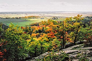
Pontiac is a municipality in the Outaouais Region of western Quebec, Canada, on the north shore of the Ottawa River. It is part of Les Collines-de-l'Outaouais Regional County Municipality, included in the National Capital Region. It should not be confused with Pontiac Regional County Municipality, which is also in the Outaouais but not included in the National Capital Region.

<span class="mw-page-title-main">Brome-Missisquoi Regional County Municipality</span> Regional county municipality in Quebec, Canada

Brome-Missisquoi is a regional county municipality in the Estrie region of Quebec, Canada. It lies in the Eastern Townships area. The seat is Cowansville. In 2021, it was transferred to the Estrie region from Montérégie.

<span class="mw-page-title-main">Les Collines-de-l'Outaouais Regional County Municipality</span> Regional county municipality in Quebec, Canada

Les Collines-de-l'Outaouais is a regional county municipality in the Outaouais region of western Quebec, Canada. The region nearly encircles the City of Gatineau, which is to the south. Its administrative seat is in Chelsea, Quebec.

<span class="mw-page-title-main">Pontiac Regional County Municipality</span> Regional county municipality in Quebec, Canada

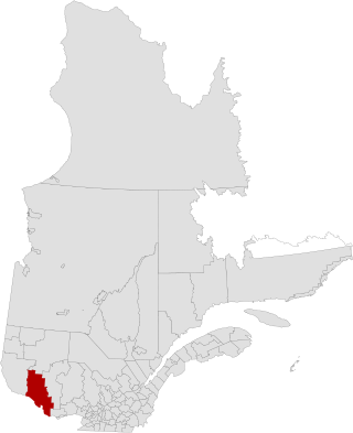
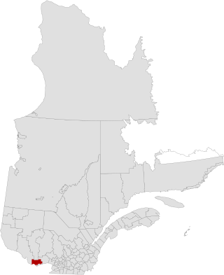
Pontiac is a regional county municipality in the Outaouais region of Quebec, Canada. Campbell's Bay is the county seat. It should not be confused with the municipality of Pontiac, which is located in the neighbouring Les Collines-de-l'Outaouais Regional County Municipality. For the electoral district see Pontiac.

<span class="mw-page-title-main">Fort-Coulonge</span> Village municipality in Quebec, Canada

Fort Coulonge is a village in the Pontiac Regional County Municipality in western Quebec, Canada, at the mouth of the Coulonge River. It is the francophone centre of the otherwise largely (57%) anglophone Pontiac MRC, with 79.6% listing French as their mother tongue in the Canada 2006 Census.

<span class="mw-page-title-main">Mansfield-et-Pontefract</span> Municipality in Quebec, Canada

Mansfield-et-Pontefract is a municipality in the Pontiac Regional County Municipality of western Quebec, Canada. It is located on the Ottawa River, northwest of Gatineau. It is the most populated municipality in the Pontiac Regional County Municipality, with most of the population and businesses concentrated along Quebec Route 148.

<span class="mw-page-title-main">Campbell's Bay, Quebec</span> Municipality in Quebec, Canada

Campbell's Bay is a municipality in Pontiac Regional County Municipality in western Quebec, Canada. Its population in 2021 was 705.

<span class="mw-page-title-main">Mayo, Quebec</span> Municipality in Quebec, Canada

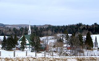
Mayo is a municipality in the Papineau Regional County Municipality of western Quebec, located northeast of the city of Gatineau. Mayo is south of the hamlet of Mulgrave-et-Derry.

<span class="mw-page-title-main">Stratford, Quebec</span> Township municipality in Quebec, Canada

Stratford is a township municipality in Le Granit Regional County Municipality in the Estrie region in Quebec, Canada. A township municipality is all or part of the territory of a township set up as a municipality.

<span class="mw-page-title-main">Rapides-des-Joachims</span> Municipality in Quebec, Canada

Rapides-des-Joachims is a municipality and village in western Quebec, Canada, part of Pontiac County in the Outaouais region. The village is situated on Rapides-des-Joachims Island on the Ottawa River, about 100 km northwest of Fort-Coulonge. It is also known as Swisha.

<span class="mw-page-title-main">Portage-du-Fort</span> Village municipality in Quebec, Canada

Portage-du-Fort is a village municipality in the Pontiac Regional County Municipality in the southwest corner of the Outaouais region of Quebec, Canada. The village lies across the Ottawa River from Chenaux, Ontario and Horton, Ontario.

<span class="mw-page-title-main">Bryson, Quebec</span> Municipality in Quebec, Canada

Bryson is a village and municipality in the Pontiac Regional County Municipality in the Outaouais region of Quebec, Canada. It is located on the northern bank of the Ottawa River.

<span class="mw-page-title-main">Waltham, Quebec</span> Municipality in Quebec, Canada

Waltham, also known as Waltham Station is a village and municipality in the Outaouais region, Quebec, Canada, part of the Pontiac Regional County Municipality. It is located at the mouth of the Noire River, along the north shore of the Ottawa River at Allumette Island.

<span class="mw-page-title-main">Sheenboro</span> Municipality in Quebec, Canada

Sheenboro is a village and municipality in the Outaouais region, part of the Pontiac Regional County Municipality, Quebec, Canada. It was formerly known as Sheen-Esher-Aberdeen-et-Malakoff. Its territory stretches along the north shore of the Ottawa River from Chichester to Rapides-des-Joachims.

<span class="mw-page-title-main">L'Isle-aux-Allumettes</span> Municipality in Quebec, Canada

L'Isle-aux-Allumettes is a municipality in the Outaouais region, part of the Pontiac Regional County Municipality, Quebec, Canada. The municipality consists primarily of Allumette Island, and also includes Morrison Island, Marcotte Island, and some minor islets, all in the Ottawa River north of Pembroke.

<span class="mw-page-title-main">Chichester, Quebec</span> Township municipality in Quebec, Canada

Chichester is a township municipality and village in the Canadian province of Quebec, located within the Pontiac Regional County Municipality.

<span class="mw-page-title-main">L'Île-du-Grand-Calumet</span> Municipality in Quebec, Canada

L'Île-du-Grand-Calumet is a municipality in the Outaouais region, part of the Pontiac Regional County Municipality, Quebec, Canada. The municipality consists primarily of Calumet Island, but also includes Lafontaine Island, French Island, Green Island, and numerous minor surrounding islets, all in the Ottawa River, approximately two kilometres from Campbell's Bay, two kilometres from Bryson.

<span class="mw-page-title-main">Clarendon, Quebec</span> Municipality in Quebec, Canada

Clarendon is a municipality in the Outaouais region, part of the Pontiac Regional County Municipality, Quebec, Canada. It is located on the north shore of the Ottawa River across from Horton Township in Ontario.

<span class="mw-page-title-main">Bristol, Quebec</span> Municipality in Quebec, Canada

Bristol is a municipality in the Ottawa Valley, on the Quebec side in the Outaouais region, part of the Pontiac Regional County Municipality, Quebec, Canada. It is located on the north shore of Lac des Chats across from Arnprior, Ontario.

<span class="mw-page-title-main">Thorne, Quebec</span> Municipality in Quebec, Canada

Thorne is a municipality in the Pontiac Regional County Municipality, Quebec, Canada, about 63 kilometres (39 mi) northwest of Downtown Gatineau, part of the Outaouais region.

References

  1. "Reference number 379882 in Banque de noms de lieux du Québec". toponymie.gouv.qc.ca (in French). Commission de toponymie du Québec.
  2. 1 2 "Litchfield". Répertoire des municipalités (in French). Ministère des Affaires municipales et de l'Habitation. Retrieved 26 October 2022.
  3. 1 2 3 "Profile table, Census Profile, 2021 Census of Population - Litchfield, Municipalité (MÉ) [Census subdivision], Quebec". www12.statcan.gc.ca. Government of Canada - Statistics Canada. 9 February 2022.
  4. 1 2 3 "Pontiac MRC Gateway: Litchfield". Pontiac MRC Gateway. Archived from the original on October 7, 2006. Retrieved 2008-05-05.
  5. 1 2 3 4 "Municipalité du Canton de Litchfield" (in French). Commission de toponymie du Québec. Retrieved 2008-05-05.
  6. "Portage-du-Fort" (in French). Commission de toponymie du Québec. Retrieved 2008-05-05.
  7. "2021 Community Profiles". 2021 Canadian Census . Statistics Canada. February 4, 2022. Retrieved 2023-10-19.
  8. "2016 Community Profiles". 2016 Canadian Census . Statistics Canada. August 12, 2021. Retrieved 2019-11-19.
  9. "2011 Community Profiles". 2011 Canadian Census . Statistics Canada. March 21, 2019. Retrieved 2014-02-01.
  10. "2006 Community Profiles". 2006 Canadian Census . Statistics Canada. August 20, 2019.
  11. "2001 Community Profiles". 2001 Canadian Census . Statistics Canada. July 18, 2021.
  12. 1996, 2001, 2006, 2011, 2016, 2021 census

Commons-logo.svg Media related to Litchfield, Quebec at Wikimedia Commons