Beginning in the 1940s the ferry began accommodating vehicles as well as passengers, with the service then linking the Ocean Highway, a major coastal route.
The service was acquired by an agency of the Commonwealth of Virginia in 1954, ceased operations in April 1964, and was replaced by the Chesapeake Bay Bridge-Tunnel. During its peak, the Little Creek Ferry operated 90 one-way trips each day with seven vessels.
The southern terminus of the ferry service in Virginia Beach (originally Princess Anne County) remains accessible today, where it continues to bisect Naval Amphibious Base Little Creek. The original northern terminus in Cape Charles also remains accessible, and these two terminals continue to serve railway barges that ferry rail cars — belonging to Bay Coast Railroad, formerly the Eastern Shore Railroad— across the mouth of the Bay.
In 1949, the northern terminus for ferry service was moved from Cape Charles to Kiptopeke where a new pier was completed in 1951 — shortening the 85 minute crossing[2] by 20 minutes.[3] That now defunct terminus with remnants of the original toll booth lie within Kiptopeke State Park, where a sign from the defunct Tourinns Motor Lodge remains near the former toll booth at picnic shelter #2.
The newly formed Virginia Ferry Corporation initiated a motor vehicle-passenger ferry service between Little Creek and Cape Charles on April 1, 1933 paralleling the existing Pennsylvania Railroad (PRR) carfloat route (operated by the PRR subsidiary, NYP&N RR Ferry)[4] between Little Creek and Cape Charles. On May 1, 1950, the ferry route was changed from Cape Charles to the newly formed artificial Harbor at Kiptopeke Beach. The VFC was a 50/50 Wilson Line & Pennsylvania RR venture, a Virginiapublic service company.
The PRR offered passenger-freight & auto ferriage between the Brooke St Terminal in Norfolk, Virginia - Old Point Comfort in Hampton, Virginia & Cape Charles, Virginia, a 36 miles (58km) run. This operation was terminated by the PRR on February 28, 1953.
Amid dissatisfaction with the VFC operations in 1954, by act of the Virginia General Assembly, the Chesapeake Bay Ferry District (CBFD) and a related oversight commission were created, initially with the hopes of improving the ferry service. However, the governmental agency was soon authorized to sell toll revenue bonds, acquire the still-operating private Little Creek Ferry and improve existing ferry service. The VFC was sold and its five operating ferries to the Chesapeake Bay Ferry District for $13 million on May 17, 1956.
A portion of the bond revenue used to purchase the Virginia Ferry Corporation was set aside to study and determine the feasibility of a fixed crossing of the lower bay. It was determined that a bridge-tunnel complex was feasible.
In 1958, the district hired its first executive director, J. Clyde Morris, a long-time governmental manager in Warwick County and the City of Newport News. Soon, steps to consider routing and implementation were underway. Consideration was given to service between the Eastern Shore and both the Peninsula and South Hampton Roads. Eventually, the shortest route, extending between the Eastern Shore and a point in Princess Anne County at Chesapeake Beach (east of Little Creek, west of Lynnhaven Inlet), was selected. An option to also provide a fixed crossing link to Hampton and the Peninsula was not pursued.[6]
In August 1960, the District sold US$200 million toll revenue bonds and the first pile of the CBBT was driven in the seabed on October 1, 1960 and the project was completed on April 15, 1964.[7] Princess Anne County consolidated with the City of Virginia Beach less than a year earlier. Ferry riders were able to view the construction for 3.5 years prior to its opening.
Ferry operations started with the Virginia ferry Corporation (VFC) on April 1 1933 between Little Creek in Princess Anne County (VA Beach today) and the town of Cape Charles. The VFC leased the PRR Steamer SS Maryland and the Carfloat No. 605. The run was across the bay was 26 miles taking 1 hour 45 minutes to cross. The first new build in 1934 for the VFC was the steamer SS DEL-MAR-VA 260 foot Length overall (LOA). She released the Carfloat No. 605 back to the PRR. The second new build in 1936 was the 260 feet (LOA) SS PRINCESS ANNE which released the SS MARYLAND back to the PRR. The third new build in 1941 was the 300 feet (LOA) the SS POCAHONTAS. The fourth vessel added in 1948 was the Motor Vessel (MV) NORTHAMPTON, a)USS LST-63, b)HMS LST-63 328 feet (LOA) converted into a roll on/roll off (RO/RO)ferry from a US Navy LST.
To lessen crossing time the VFC bought land eight and half miles down the Del-Mar-Va peninsula from Cape Charles at Kiptopeke Beach and created a man-made harbor using nine concrete surplus ships from WWII. This shortened the crossing from 26 miles to 21 miles, cutting 20 minutes in the actual crossing time. The first crossing from Kiptopeke was made by the SS PRINCESS ANNE on May 1 1950.
A fifth vessel was added in 1951, the MV ACCOMAC, a)SS Virginia LEE, b)MV Holiday. Built in 1928 she is 300 feet (LOA).
In April 1954 the SS PRINCESS ANNE was cut in two and a 90-foot midsection built bringing her length to 350 feet (LOA).
Also in April 1955 the SS DEL-MAR-VA was cut in two adding 90 feet in her length to 350 feet (LOA).
Up bounds in traffic demanded more than the VFC could provide and the VFC was sold to the Chesapeake Bay Ferry District (CBFD) on May 17 1956.
CBFT first order of business was to reestablish a ferry crossing from Old Point Comfort in Hampton VA. (Fort Monroe) to the Del-Mar-Va peninsula. With the opening of the Hampton Roads Bridge Tunnel (HRBT) on November 1 1957, the Willoughby Spit-Old Point Comfort ferry ceased. This left a ferry terminal open for use. The terminal was modified to handle the much larger vessels CBFD fleet. Also in 1957 the SS POCAHONTAS was cut in two with a 76-foot midsection build increasing her length to 376 feet (LOA).
With a second route being established required another vessel and another US Navy LST was converted into RO/RO ferry at Newport News Shipbuilding in 1957. She is the MV OLD POINT COMFORT, a) USS LST-970, b) MV Albany. The OLD Point COMFORT reestablished ferry service to Old Point Comfort on February 15 1958.
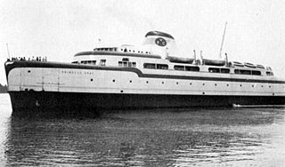
In 1959 another US Navy surplus LST was purchased to become the MV VIRGINIA BEACH, a)USS LST-510, b)USS Buncombe County LST-510. Converted into a RO/RO ferry at Norfolk Shipbuilding & Drydock in 1959.
Due to lack of patronage the Old Point Comfort-Kiptopeke route was terminated in September 1960, one month before the first pile was driven for the CBBT.
The CBFD could operate seven vessels during peak times of the year carrying 636 autos of that time on a one-way trip. They ranged from 300 feet in length to 376 feet and averaged between 12 and 14 knots in speed, the MV ACCOMAC being the fastest and the LST's being the slowest. They had a full restaurant onboard and from Memorial Day to Labor Day offered moonlight cruises on Wednesday and Saturday nights with a full orchestra on the 8:05PM departures from Little Creek. They operated in extreme weather conditions only stopping for whole gale winds. They would be awash with spray, sometimes green water and numerous passengers seasick. It was like going on a small ocean liner for brief period of time. The cost to cross the bay was in 1962 was $3.00 for an automobile and $.85 per passenger. Today to cross the CBBT is $16.00 in the off-season and $18.00 during peak season.
The SS POCAHONTAS flagship of the fleet made the last crossing on April 15 1964. Five of the ferries were sold to the Delaware River & Bay Authority to start a new crossing between Lewes, DE & North Cape May, NJ. Only one of the old ferry fleet is still in operation and that is the c)MV VIRGINIA BEACH now operating for the Cross Sound Ferry (CSF) between New London, CT & Orient Point, NY under the name d)Cape Henlopen, c)Virginia Beach, b) USS Buncombe County LST-510, a)USS LST-510. The Virginia Dept. of Highways has carried the Pocahontas name on to the newest ferry built for the Jamestown-Scotland wharf run on the James R. The old ferry terminal at Kiptopeke is now a state park and most of the old ferrying is still in use for park use. The Little Creek terminal is pretty much gone and what is left is commercial.[8]
The ferry service took 85 minutes during clear weather.[2]
The SS Delmarva, SS Princess Anne operated out of Cape Charles to Little Creek from about 1933 to 1941. The SS Pocahontas augmented service through 1950, with other ferries following later.
The flagship of the seven-ship fleet, the 367-ft. SS Pocahontas — which reportedly carried a cask containing earth from the grave in England of the legendary Native American Princess Pocahontas— carried 1,200 passengers and 120 vehicles. The six other ferries carried from 68 to 120 cars and up to 1,200 passengers.[2] Service ran hourly until 1 a.m.[2]
The Commonwealth of Virginia reused the name "Pocahontas" for the newest of the current ferryboats at the Jamestown-Scotland Ferry on the James River
Cape Charles is a town / municipal corporation in Northampton County, Virginia, United States. The population was 1,009 as of the 2010 Census.
Hampton Roads is the name of both a body of water in the United States that serves as a wide channel for the James, Nansemond, and Elizabeth rivers between Old Point Comfort and Sewell's Point near where the Chesapeake Bay flows into the Atlantic Ocean, and the surrounding metropolitan region located in the southeastern Virginia and northeastern North Carolina portions of the Tidewater Region.
The Cape May–Lewes Ferry is a ferry system in the United States that traverses a 17-mile (27 km) crossing of the Delaware Bay connecting North Cape May, New Jersey with Lewes, Delaware. The ferry constitutes a portion of U.S. Route 9 and is the final crossing of the Delaware River-Delaware Bay waterway before it meets the Atlantic Ocean. It is only one of two direct crossings between Delaware and New Jersey, the other being the Delaware Memorial Bridge
The Chesapeake Bay Bridge–Tunnel is a 17.6-mile (28.3 km) bridge–tunnel that crosses the mouth of the Chesapeake Bay between Delmarva and Hampton Roads in the U.S. state of Virginia. It opened in 1964, replacing ferries that had operated since the 1930s. A major project to dualize its bridges was completed in 1999, and in 2017 a similar project was started to dualize one of its tunnels.
Joint Expeditionary Base–Little Creek (JEB–LC), formerly known as Naval Amphibious Base Little Creek and commonly called simply Little Creek, is the major operating base for the Amphibious Forces in the United States Navy's Atlantic Fleet. The base comprises four locations in three states, including almost 12,000 acres (4,900 ha) of real estate. Its Little Creek location in Virginia Beach, Virginia, totals 2,120 acres (860 ha) of land. Outlying facilities include 350 acres (140 ha) located just north of Training Support Center Hampton Roads in Virginia Beach and 21 acres (8.5 ha) known as Radio Island at Morehead City, North Carolina, used for U.S. Coast Guard ships and personnel as well as serves as an amphibious embarkation/debarkation area for U.S. Marine Corps units at Marine Corps Base Camp Lejeune, North Carolina. It is also home to the Naval School of Music.
The Eastern Shore of Virginia is the easternmost region of the Commonwealth of Virginia in the United States. It consists of two counties on the Atlantic coast. It is detached from the mainland of Virginia by the Chesapeake Bay. The 70-mile-long (110 km) region is part of the Delmarva Peninsula. Its population was 45,695 as of 2020.
South Hampton Roads is a region located in the extreme southeastern portion of Virginia's Tidewater region in the United States with a total population of 1,191,937. It is part of the Virginia Beach-Norfolk-Newport News, VA-NC MSA, which itself has a population of 1,724,876.
County of Princess Anne is a former county in the British Colony of Virginia and the Commonwealth of Virginia in the United States, first incorporated in 1691. The county was merged into the city of Virginia Beach on January 1, 1963, ceasing to exist.
Transportation in the Commonwealth of Virginia is by land, sea and air. Virginia's extensive network of highways and railroads were developed and built over a period almost 400 years, beginning almost immediately after the founding of Jamestown in 1607, and often incorporating old established trails of the Native Americans.
State Route 168 is a primary state highway in the South Hampton Roads region of the U.S. state of Virginia. It runs from the border with North Carolina through the independent cities of Chesapeake and Norfolk where it ends in the Ocean View area near the Hampton Roads Bridge-Tunnel.
The Chesapeake Bay Bridge and Tunnel District is a political subdivision of the Commonwealth of Virginia. It is overseen by the Chesapeake Bay Bridge and Tunnel Commission, and operates the Chesapeake Bay Bridge-Tunnel between the Hampton Roads and Eastern Shore regions of the state. The District comprises six cities, Virginia Beach, Norfolk, Portsmouth, Chesapeake, Hampton, Newport News, and the two Eastern Shore counties of Northampton and Accomack.
U.S. Route 60 (US 60) in the Commonwealth of Virginia runs 303 miles (488 km) west to east through the central part of the state, generally close to and paralleling the Interstate 64 corridor, except for the crossing of the Blue Ridge Mountains, and in the South Hampton Roads area.
State Route 165 is a primary state highway in the U.S. state of Virginia. The state highway runs 39.75 miles (63.97 km) from U.S. Route 17 Business in Chesapeake north to SR 337 in Norfolk. SR 165 is a C-shaped route that connects Chesapeake and Norfolk in the Hampton Roads metropolitan area indirectly via Virginia Beach. The highway's east–west segment connects the Chesapeake communities of Deep Creek and Great Bridge with the Princess Anne part of Virginia Beach. SR 165's northwest–southeast portion connects the Princess Anne area with Virginia Beach's Salem and Kempsville communities and with Norfolk. Within Norfolk, the state highway parallels Interstate 64 (I-64) while passing through the eastern and northern areas of the city near Norfolk International Airport and Naval Station Norfolk. Much of SR 165 is a multi-lane divided highway, but there are significant two-lane stretches in all three of the independent cities the highway serves.
State Route 184 is a primary state highway in the U.S. state of Virginia. The state highway runs 3.20 miles (5.15 km) from Washington Avenue and Bay Street in Cape Charles east to U.S. Route 13 and US 13 Business near Bayview. SR 184 connects US 13 with Cape Charles in southern Northampton County. The state highway is the old alignment of US 13 from when the U.S. highway used the Little Creek-Cape Charles Ferry to cross the Chesapeake Bay to Norfolk. SR 184 was designated after US 13 was extended south to the new terminal of the Little Creek Ferry at Kiptopeke and later the Chesapeake Bay Bridge-Tunnel.
USS Buncombe County (LST-510) was an LST-491-class tank landing ship built for the United States Navy during World War II. Named for Buncombe County, North Carolina, she was the only U.S. Naval vessel to bear the name. She currently serves as a ferry between New London, Connecticut, and Orient, Long Island.
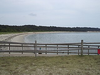
Kiptopeke State Park is a state park located in the southern end of the Eastern Shore of Virginia and the Delmarva Peninsula in Northampton County, near Cape Charles. From 1949, the site was owned by the Virginia Ferry Corporation and used through 1964 as the northern terminus for the Little Creek-Cape Charles Ferry service which crossed the lower Chesapeake Bay from the Eastern Shore / Delmarva to Norfolk and Hampton Roads harbor on the Western Shore. In 1964, the ferry service was replaced by the Chesapeake Bay Bridge-Tunnel which opened up giving automobile traffic convenient access to the park, the Cape, Delmarva and "The Shore" to the urban centers to the west in North Carolina, Virginia, Maryland and the District of Columbia.
Historically, the harbor was the key to the Hampton Roads area's growth, both on land and in water-related activities and events. Ironically, the harbor and its tributary waterways were both important transportation conduits and obstacles to other land-based commerce and travel. For hundreds of years, state and community leaders have worked to develop solutions to accommodate both.
The New York, Philadelphia and Norfolk Railroad was a railroad line that ran down the spine of the Delmarva Peninsula from Delmar, Maryland to Cape Charles, Virginia and then by ferry to Norfolk, Virginia. It became part of the Pennsylvania Railroad system.
SS Princess Anne was a Virginia Ferry Company (VFC) steamship that plied the route across Chesapeake Bay between Little Creek, near Norfolk, and Kiptopeke Beach, at the southern end of the Eastern Shore of Virginia. She was known for her streamlined superstructure, designed by Raymond Loewy, which attracted the attention of the newsreels and the nautical press.
References
↑ "Pennsylvania Railroad, Tables 78, 79". Official Guide of the Railways. 78 (12). National Railway Publication Company. May 1946.
↑ "Pennsylvania Railroad, Table 78a". Official Guide of the Railways. 74 (1). National Railway Publication Company. June 1941.
↑ 1. Steamship Historical Society of America publication, PowerShips No. 279 Fall 2011 article "Vessel of the Virginia Ferry Corporation 1930-1933", Author William L. Baxter, 2. Steamship Historical Society of America publication, PowerShips No.296, Winter 2016, article Vessels of the Virginia Ferry Corporation: 1956 to present, Author William L. Baxter
↑ Steamship Historical Society of America publication PowerShips No. 296, Winter 2016 article Vessels of the Virginia Ferry corporation: 1956 to Present, author William L. Baxter
↑ 1. Steamship Historical Society of America publication PowerShips No. 279 Fall 2011, article Vessels of the Virginia Ferry Corporation 1930-1956, Author William L. Baxter (I am the one rewriting above, it is my article), 2. Steamship Historical Society of America publication PowerShips No. 296, Winter 2016, article Vessels of the Virginia Ferry Corporation: 1956 to Present, author William L. Baxter
This page is based on this Wikipedia article Text is available under the CC BY-SA 4.0 license; additional terms may apply. Images, videos and audio are available under their respective licenses.