
The Au Sable River in Michigan, United States runs approximately 138 miles (222 km) through the northern Lower Peninsula, through the towns of Grayling and Mio, and enters Lake Huron at Au Sable. It is considered one of the best brown trout fisheries east of the Rockies and has been designated a blue ribbon trout stream by the Michigan Department of Natural Resources. In French, au sable literally means "at the sand." A 1795 map calls it the Beauais River.

Wexford County is a county located in the U.S. state of Michigan. As of the 2010 census, the population was 32,735. The county seat is Cadillac.

Newaygo County is a county in the U.S. state of Michigan. As of the 2010 United States Census, the population was 48,460. The county seat is White Cloud. The county was created in 1840, and was organized in 1851. It was either named for an Ojibwe leader who signed the Treaty of Saginaw in 1819 or for an Algonquian word meaning "much water".

Manistee County is a county located in the U.S. state of Michigan. As of the 2010 census, the population was 24,733. The county seat is Manistee. The name "Manistee" is from an Ojibwe word first applied to the principal river of the county. The derivation is not certain, but it may be from ministigweyaa, "river with islands at its mouth". See also, List of Michigan county name etymologies and Kaministiquia River.

Kalkaska County is a county located in the U.S. state of Michigan. As of the 2010 United States Census, the population was 17,153. The county seat is Kalkaska.

Benzie County is a county in the U.S. state of Michigan. As of the 2010 census, the population was 17,525. The county seat is Beulah. The county was initially set off in 1863 and organized in 1869.

Manistee is a city in the U.S. state of Michigan. The population was 6,226 at the 2010 census. It is the county seat of Manistee County. The name "Manistee" is from an Ojibwe word first applied to the principal river of the county. The derivation is not certain, but it may be from ministigweyaa, "river with islands at its mouth". Other sources claim that it was an Ojibwe term meaning "spirit of the woods".

The Huron-Manistee National Forests are two separate national forests, the Huron National Forest and the Manistee National Forest, combined in 1945 for administration purposes and which comprise 978,906 acres (3,960 km2) of public lands, including 5,786 acres (23 km2) of wetlands, extending across the northern lower peninsula of Michigan. The Huron-Manistee National Forests provide recreation opportunities for visitors, habitat for fish and wildlife, and resources for local industry. The headquarters for the forests is in Cadillac, Michigan.

The Manistee National Forest is a national forest located in the Lower Peninsula of Michigan. It has a total area of 540,187 acres (2,190 km2). It was established in 1938, and combined with the Huron National Forest in 1945 for administrative purposes, creating the Huron-Manistee National Forests. However, they are two separate forest units, as they are not connected. The area is popular for hiking, fishing, camping, boating, snowmobiling, cross-country skiing and hunting. The North Country Trail passes through it, and connects with the 11-mile Manistee River Trail to form a 23-mile loop. The highest point in the lower peninsula, Briar Hill, is located here. The Manistee National Forest is not one continuous mass, but is a "mosaic" broken by private property and towns. The headquarters for the forest is in Cadillac, Michigan.
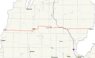
M-55 is a state trunkline highway in the northern part of the US state of Michigan. M-55 is one of only three state highways that extend across the Lower Peninsula from Lake Huron to Lake Michigan; the others are M-46 and M-72. The highway crosses through rural forest and farmlands to connect Manistee with Tawas City. M-55 crosses two of the major rivers in the state. Two sections of the highway follow along freeways near Cadillac and West Branch. Running for 150.944 miles (242.921 km) through the state, M-55 is maintained by the Michigan Department of Transportation (MDOT).

The White River is a 23.6-mile-long (38.0 km) river located on the western side of the Lower Peninsula of the U.S. state of Michigan. The White River rises from the extensive Oxford Swamp in north central Newaygo County and flows out into an upland area. The rural town of Hesperia borders the river here.
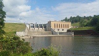
Tippy Dam or Tippy Hydro was built 1918 and is a hydroelectric dam operated by Consumers Energy. The original name of the dam was Junction Hydro, but it was renamed to honor a Consumers board of directors member, Charles W. Tippy. The dam spans the Manistee River about 170 miles from its headwaters which include Manistee Lake, on the river's way to Lake Michigan.

The Manistee Pierhead lights are a pair of active aids to navigation located on the north and south pier in the harbor of Manistee, Michigan, "Lake Michigan’s Victorian Port City."

Parkdale is an unincorporated community and census-designated place in Manistee Township, Manistee County, Michigan, United States. Its population was 704 as of the 2010 census. The community is in the southwest corner of the township, on the northern edge of Manistee Lake where the Manistee River enters the lake. It is on US 31 near the junction with M-55 on the northern boundary of the Manistee city limits.

Manistee Lake is a water body adjacent to the city of Manistee, Michigan. Its primary inlet, as well as its outlet, is the Manistee River, flowing to Lake Michigan. The tributary Little Manistee River enters the southeast end of the lake before the outlet.
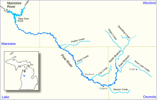
The Pine River, formerly known as the South Branch Manistee River, is a 53.6-mile-long (86.3 km) tributary of the Manistee River in the U.S. state of Michigan. It forms at the confluence of the North Branch and East Branch of the Pine River in northwest Osceola County, flows southwest, then west and north through the northeast corner of Lake County and into southwest Wexford County, emptying into the Tippy Dam Pond on the Manistee River in Manistee County. The Pine River watershed drains an area of 265 square miles (690 km2).

