Related Research Articles

Hueco Tanks is an area of low mountains and historic site in El Paso County, Texas, in the United States. It is located in a high-altitude desert basin between the Franklin Mountains to the west and the Hueco Mountains to the east. Hueco is a Spanish word meaning hollows and refers to the many water-holding depressions in the boulders and rock faces throughout the region. Due to the unique concentration of historic artifacts, plants and wildlife, the site is under protection of Texas law; it is a crime to remove, alter, or destroy them.

Pictograph Cave is an area of three caves located 5 miles (8.0 km) south of Billings, Montana, United States, preserved and protected in the 23-acre (9.3 ha) Pictograph Cave State Park.

This is a list of the buildings, sites, districts, and objects listed on the National Register of Historic Places in Guam. There are currently 134 listed sites spread across 17 of the 19 villages of Guam. The villages of Agana Heights and Mongmong-Toto-Maite do not have any listings. Listed historic sites include Spanish colonial ruins, a few surviving pre-World War II ifil houses, Japanese fortifications, two massacre sites, and a historic district. Two other locations that were previously listed have been removed from the Register.

The Kolomoki Mounds is one of the largest and earliest Woodland period earthwork mound complexes in the Southeastern United States and is the largest in Georgia. Constructed from 350CE to 600CE, the mound complex is located in southwest Georgia, in present-day Early County near the Chattahoochee River.

Sky Meadows State Park is a 1,862-acre (754 ha) park in the Virginia state park system. It is located in extreme northwest Fauquier County, Virginia in the Blue Ridge Mountains, near Paris, Virginia. It is about an hour outside of the Washington, D.C. metro region.

The Palatki Heritage Site is an archaeological site and park located in the Coconino National Forest, near Sedona, in Arizona, United States at approximately 34 55' 4"N, 111 53' 59"W. In the Hopi language Palatki means 'red house'.
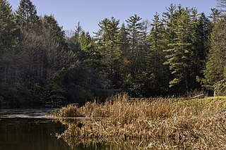
Little Beaver State Park is state park in Raleigh County, West Virginia. It is located near Beckley, West Virginia, about 2 miles (3.2 km) south of I-64 at Grandview Road, exit 129A. The park sits on the shores of 18-acre (0.07 km²) Little Beaver Lake.
Water glyphs are a recurring type of petroglyph found across the American southwest, but primarily in southern Utah, northern Arizona, and Nevada. The symbols are thought to be of ancient origin and have been dated using x-ray fluorescence to around 2000 years. Classification as a water glyph requires the presence of certain distinctive characteristics including both visual elements and location. Although the glyphs have likely been previously noted by local ranchers and farmers, the recurring pattern was first documented in 1997.

Coso Rock Art District is a rock art site containing over 100,000 Petroglyphs by Paleo-Indians and/or Native Americans. The district is located near the towns of China Lake and Ridgecrest, California. Big and Little Petroglyph Canyons were declared a National Historic Landmark in 1964. In 2001, they were incorporated into this larger National Historic Landmark District. There are several other distinct canyons in the Coso Rock Art District besides the Big and Little Petroglyph Canyons. Also known as Little Petroglyph Canyon and Sand Tanks, Renegade Canyon is but one of several major canyons in the Coso Range, each hosting thousands of petroglyphs. The majority of the Coso Range images fall into one of six categories: bighorn sheep, entopic images, anthropomorphic or human-like figures, other animals, weapons & tools, and "medicine bag" images. Scholars have proposed a few potential interpretations of this rock art. The most prevalent of these interpretations is that they could have been used for rituals associated with hunting.

Chumash rock art is a genre of paintings on caves, mountains, cliffs, or other living rock surfaces, created by the Chumash people of Southern California. Pictographs and petroglyphs are common through interior California, the rock painting tradition thrived until the 19th century. Chumash rock art is considered to be some of the most elaborate and plentiful rock art tradition in the region.

The Burro Flats site is a painted cave site located near Burro Flats, in the Simi Hills of eastern Ventura County, California, United States. The Chumash-style "main panel" and the surrounding 25-acres were listed on the National Register of Historic Places in 1976, with a boundary decrease in 2020. The main panel includes dozens of pictographs in a variety of colors. The cave is in the mountains, near the bi-lingual Chumash/Fernandeno village of Huwam/Jucjauynga. The Burro Flats painted cave and the rest of the former Santa Susana Field Laboratory are not accessible to the public.

Cañon Pintado, meaning painted canyon, is an archaeological site of Native American rock art located in the East Four Mile Draw, 10.5 miles (16.9 km) south of Rangely in Rio Blanco County, Colorado. Led by Ute guides, the Domínguez–Escalante expedition, Spanish missionaries in search of a route to California in 1776, passed through this region as they moved north and then west into Utah. The first Europeans to the area, they named it Cañon Pintado, meaning "painted canyon".

Seminole Canyon State Park and Historic Site is a state park in the U.S. state of Texas. It is located off U.S. Route 90, east of the Pecos River High Bridge, 9 miles (14 km) west of Comstock in Val Verde County. The park is conducive to camping, biking, bird watching, back packing and archeological study. Cave art and archeological artifacts date back to the earliest human habitation in the area. The park is part of the larger Seminole Canyon Archeological District on the National Register of Historic Places.

Gwin Dudley Home Site, also known as Twin Chimneys, is a historic home site located at Smith Mountain Lake, Wirtz, Franklin County, Virginia. The site consists of two extant stone chimneys that are situated 31 feet, 8 inches apart, indicating the length of the house, which was lost to fire in the early 20th century. They were part of a house erected about 1795.
Indian Paintings is a historic archaeological site located near Maiden Spring, Tazewell County, Virginia. These pictographs are on a rock face high on Paint Lick Mountain. Stretched in a horizontal line along the irregular exposure is a series of simple images representing thunderbirds, human figures, deer, arrows, trees, and the sun, all painted in a red medium using iron oxide.
The Talagi Pictograph Cave is a rock art site on the island of Guam. It is located on property owned by the government of Guam within the bounds of Andersen Air Force Base on the northern part of the island near Tarague Beach. The cave contains thirteen pictographs representing human figures, and a places where limestone mortar was used that is of prehistoric origin. Based on the characteristics of the figures, it is believed that they were probably the work of a single individual. It is one of a small number known rock art sites on the island.
The Mahlac Pictograph Cave is a rock art site on the island of Guam. It is located high in the southern mountains of the island, and contains more than 40 images, rendered in paints that are white, red, brown, and black. The art was carefully analyzed in 2011, and a radiocarbon date of c. 600 CE was obtained from a paint sample. The meaning of the art is a subject of debate.

Petit Jean State Park is the oldest state park in Arkansas. It is located in the central northern part of the state, in western Conway County, atop Petit Jean Mountain, a ridge between the Ozark and Ouachita Mountains. One of the features the park is noted for is prehistoric rock art, some of which is accessible to park visitors via its hiking trails. A total of twelve such sites have been listed on the National Register of Historic Places for their importance. Most of the rock art has been dated to about 1500 CE, and is not obviously associated with habitation sites or other sites bearing evidence of other Native American activities.
Big Gyp Cave Pictograph site (14CM305) in Comanche County, Kansas, is an archeological site with pictographs in a cave. It was listed on the National Register of Historic Places in 1978.
Cueva La Mora is the name of a cave and archaeological site located in or near Comerío, Puerto Rico. The cave was added to the United States National Register of Historic Places on March 10, 1983, due to its importance in yielding information about the Pre-Columbian history of Puerto Rico and the Caribbean.
References
- 1 2 "National Register Information System". National Register of Historic Places . National Park Service. July 9, 2010.
- ↑ "Virginia Landmarks Register". Virginia Department of Historic Resources. Retrieved June 5, 2013.
- ↑ William Hranicky (February 1990). Material Culture from Prehistoric Virginia, Volume 1: Little Mountain Pictograph Site (44NT13), p. 443. Virginia Department of Historic Resources. ISBN 9781438966618.
