Montgomery County is a county located in the central portion of the U.S. state of Georgia. As of the 2010 census, the population was 9,123. The county seat is Mount Vernon.

Montgomery County is a county located in the Valley and Ridge area of the U.S. state of Virginia. As population in the area increased, Montgomery County was formed in 1777 from Fincastle County, which in turn had been taken from Botetourt County. As of the 2020 census, the population was 99,721. Its county seat is Christiansburg. Montgomery County is part of the Blacksburg–Christiansburg, VA Metropolitan Statistical Area. It is dominated economically by the presence of Virginia Tech, Virginia's third largest public university, which is the county's largest employer.

Radford is an independent city in the U.S. state of Virginia. As of 2020, the population was 16,070 by the United States Census Bureau. For statistical purposes, the Bureau of Economic Analysis combines the city of Radford with neighboring Montgomery County.

Pulaski County is a county located in the southwestern part of the U.S. state of Virginia. As of the 2020 census, the population was 33,800. Its county seat is Pulaski. Pulaski County is part of the Blacksburg–Christiansburg, VA Metropolitan Statistical Area.

Floyd County is a county located in the Commonwealth of Virginia. As of the 2020 census, the population was 15,476. Its county seat is the town of Floyd. Floyd County is included in the Blacksburg-Christiansburg, VA Metropolitan Statistical Area. Named after Virginia politician John Floyd, the county was established in 1831. The county is located on the high plateau of the Blue Ridge Mountains and surrounded by the Little River. In the 1960s and 1970s, Floyd proved popular with people in the era's counterculture, particularly those who wanted to live in closer contact with nature.

Christiansburg is a town in Montgomery County, Virginia, United States. The population was 21,041 at the 2010 census. It is the county seat of Montgomery County. Christiansburg, Blacksburg and the city of Radford are the three principal municipalities of the Blacksburg–Christiansburg Metropolitan Statistical Area, which encompasses those municipalities, all of Montgomery County, and three other counties.
The New River Valley is a region along the New River in Southwest Virginia in the United States.

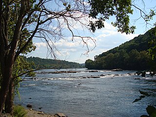
The New River is a river which flows through the U.S. states of North Carolina, Virginia, and West Virginia before joining with the Gauley River to form the Kanawha River at the town of Gauley Bridge, West Virginia. Part of the Ohio River watershed, it is about 360 miles (580 km) long.

The Rappahannock River is a river in eastern Virginia, in the United States, approximately 195 miles (314 km) in length. It traverses the entire northern part of the state, from the Blue Ridge Mountains in the west where it rises, across the Piedmont to the Fall Line, and onward through the coastal plain to flow into the Chesapeake Bay, south of the Potomac River.

The Roanoke River runs 410 miles (660 km) long through southern Virginia and northeastern North Carolina in the United States. A major river of the southeastern United States, it drains a largely rural area of the coastal plain from the eastern edge of the Appalachian Mountains southeast across the Piedmont to Albemarle Sound. An important river throughout the history of the United States, it was the site of early settlement in the Virginia Colony and the Carolina Colony. An 81-mile (130 km) section of its lower course in Virginia between the Leesville Lake and Kerr Lake is known as the Staunton River, pronounced, as is the Shenandoah Valley city of that name. It is impounded along much of its middle course to form a chain of reservoirs.

Kentucky Route 80 (KY 80) is a 483.55-mile-long (778.20 km) state highway in the southern part of the U.S. state of Kentucky. The route originates on the state's western border at Columbus in Hickman County, and stretches across the southern portion of the state, terminating southeast of Elkhorn City on the Virginia state line. It is the longest Kentucky State Highway, though the official distance as listed in route logs is much less due to multiple concurrencies with U.S. Route 68 (US 68) and U.S. Route 23.

Area codes 540 and 826 are telephone area codes in the North American Numbering Plan (NANP) for the north-western region of the U.S. State of Virginia, including the Shenandoah Valley, the Roanoke metropolitan area, the northern and eastern parts in Virginia of the New River Valley, and the outermost parts of the Washington metropolitan area. The Virginia State Corporation Commission authorized the addition of 826 to the numbering plan area for implementation in May 2022.

State Route 114 is a primary state highway in the U.S. state of Virginia. Known as Peppers Ferry Road, the state highway runs 10.32 miles (16.61 km) from U.S. Route 11 in Fairlawn east to US 460 in Christiansburg. SR 114 is the northernmost of three east–west highways between Radford and Christiansburg and the most direct highway between Radford and Blacksburg. The state highway also connects those cities with the Radford Army Ammunition Plant.
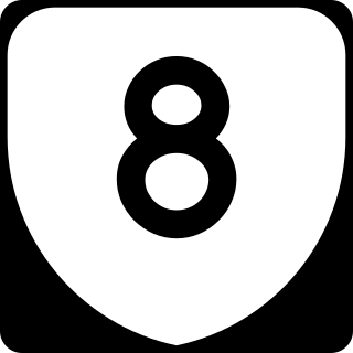
State Route 8 is a primary state highway in the U.S. state of Virginia. The state highway runs 55.88 miles (89.93 km) from the North Carolina state line near Palmetto, where the highway continues south as North Carolina Highway 8, north to U.S. Route 11 in Christiansburg. SR 8 is part of a 151-mile (243 km) two-state highway 8 system and is the main north–south highway of Patrick County, Floyd County, and southern Montgomery County, connecting their respective county seats of Stuart, Floyd, and Christiansburg with each other and with the Blue Ridge Parkway. The state highway also links the New River Valley region of Virginia with Southside Virginia via US 58 and the Piedmont Triad of North Carolina via NC 8.

Difficult Run is a 15.9-mile-long (25.6 km) tributary stream of the Potomac River in Northern Virginia in the United States. The area has had many historical uses dating back to the early 1800s. Today, the area is used recreationally by visitors interested in the watershed's variety of options including hiking, biking, fishing, boating, climbing, and bird watching. The wildlife at Difficult Run is vast as 163 different species can be seen depending on the season. There are 41 different soil types found on the trail and alongside the stream. The stream is part of the greater 57.7- square-mile Drainage basin, or watershed, located in the north-central portion of Fairfax County and drains directly to the Potomac River.

State Route 100 is a primary state highway in the U.S. state of Virginia. The state highway runs 53.31 miles (85.79 km) from U.S. Route 221 in Hillsville north to SR 61 in Narrows. SR 100 is one of the major highways of the New River Valley, connecting Narrows and Pearisburg in Giles County with Dublin, Pulaski, and Interstate 81 (I-81) in Pulaski County.

The Blue Ridge Mountains Council is a Boy Scouts of America council located in Roanoke, Virginia, that serves Scouts in southwest and south central Virginia. The Blue Ridge Mountains Council owns and operates the Blue Ridge Scout Reservation in Pulaski County, Virginia, the largest Council-owned Scout reservation in the United States. The council's Tutelo Lodge is part of the Order of the Arrow.

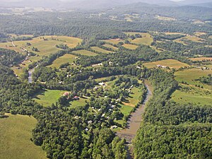
Snowville is a census-designated place (CDP) located in southeastern Pulaski County in the Commonwealth of Virginia. The population, as of the 2010 Census, was 149. It is part of the Blacksburg–Christiansburg Metropolitan Statistical Area.
Virginia's 7th House of Delegates district is one of 100 seats in the Virginia House of Delegates, the lower house of the state's bicameral legislature. District 7 covers all of Floyd County and portions of Montgomery County and Pulaski County. The district is represented by Republican Nick Rush.