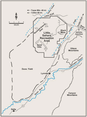
The recreation area is managed by the Bureau of Land Management of the United States Department of the Interior.[4] A 9,000-acre (36km2) portion of the northwest corner of the facility has been designated as The Rockwell Natural Area and is off limits to vehicles to preserve and shelter desert plants and animals.[2][5] Although the entire recreation area is located within Juab County, the dune field (which covers an area of 220 square miles [570km2]), extends southwest into Millard County, nearly as far as the city of Delta.[6]
Geology
Little Sahara Sand Dunes from 20,000 feet (6,100m), August 2009
The Little Sahara sand dunes are remnants of a large river delta formed by the Sevier River from about 12,500 to 20,000 years ago. The river emptied into ancient Lake Bonneville near the present day mouth of Leamington Canyon. After Lake Bonneville receded, winds transported the sand from the river delta to the current location. The dunes are still moving 5 to 9 feet (1.5 to 2.7m) per year.[6] One of the primary barriers to the sand movement are the Sand Hills, which are located entirely within the recreation area and substantially slow the movement of the blowing sand.[6]
Spring Break 2004 at the Sand Mountain camping area
Little Sahara is one of the most popular locations in the state for all-terrain vehicle (ATV) riding. Riders can enjoy riding on 60,000 acres (240km2) of sand dunes, trails and sage brush flats. Within the Sand Hills is Sand Mountain, a 700-foot (210m) wall of sand that challenges experienced riders and the most capable machines. Visitors also enjoy camping, hiking, mountain biking, photography, horseback riding, snowmobiling, stargazing, trail running, sand surfing, sand skiing/snowboarding, paragliding, and sand sledding. There are 255 improved campsites spread across four campgrounds with access to 40 toilets and two sources for potable water. Dispersed camping is common outside of the campground areas. A visitor center is open Thursday - Monday, and closed Tuesday and Wednesday from spring - fall. The recreation area sees the highest number of visitors over holiday weekends from spring to fall.
Wildlife
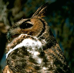
Great Horned Owl
The area is home to typical Great Basin Desert wildlife including mule deer, pronghorn antelope, snakes, lizards and birds of prey. Great horned owls make their home among juniper trees in the Rockwell Natural Area.[5]
Climate
Little Sahara Recreation Area has a cold semi-arid climate (Köppen: BSk) with cold winters and hot summers.
Climate data for Little Sahara Recreation Area, Utah, 1991–2020 normals, extremes 1979–present
This page is based on this Wikipedia article Text is available under the CC BY-SA 4.0 license; additional terms may apply. Images, videos and audio are available under their respective licenses.


