
Oxford is a city and non-metropolitan district in Oxfordshire, England, of which it is the county town. Founded in the 8th century, it was granted city status in 1542. The city is located at the confluence of the rivers Thames and Cherwell. It had a population of 163,257 in 2022. It is 56 miles (90 km) north-west of London, 64 miles (103 km) south-east of Birmingham and 61 miles (98 km) north-east of Bristol. The city is home to the University of Oxford, the oldest university in the English-speaking world; it has buildings in every style of English architecture since late Anglo-Saxon. Oxford's industries include motor manufacturing, education, publishing, science, and information technologies.

Oxfordshire is a ceremonial county in South East England. The county is bordered by Northamptonshire and Warwickshire to the north, Buckinghamshire to the east, Berkshire to the south, and Wiltshire and Gloucestershire to the west. The city of Oxford is the largest settlement and county town.

Oxford East is a constituency represented in the House of Commons of the UK Parliament by Anneliese Dodds of the Labour Party, who also serves as party chair.

Littlemore is a district and civil parish in Oxford, England. The civil parish includes part of Rose Hill. It is about 2+1⁄2 miles (4 km) southeast of the city centre of Oxford, between Rose Hill, Blackbird Leys, Cowley, and Sandford-on-Thames. The 2011 Census recorded the parish's population as 5,646, with the electoral ward having a total population of 6,441.

The River Evenlode is a tributary of the Thames in Oxfordshire. It rises near Moreton-in-Marsh, Gloucestershire, in the Cotswold Hills and flows south-east to the Thames, its valley providing the route of the southern part of the Cotswold Line. The river flows for 45 miles (72 km) from source to the River Thames.

Sandford-on-Thames, also referred to as simply Sandford, is a village and Parish Council beside the River Thames in Oxfordshire just south of Oxford. The village is just west of the A4074 road between Oxford and Henley.

The A4074 is a British A road from the Reading suburb of Caversham to the Heyford Hill roundabout on the Oxford Ring Road.

The Oxford Science Park (OSP) is a science and technology park located on the southern edge of the city of Oxford, England. It was officially opened in 1991 and is owned by Magdalen College, Oxford. The park maintains strong links with the nearby University of Oxford and currently contains just over 60 companies.

Kennington Railway Bridge is a railway bridge over the River Thames near Kennington, Oxfordshire between Sandford Lock and Iffley Lock. It carries the freight railway branch line that serves the BMW Mini factory at Cowley. The freight railway is part of the former Wycombe Railway that linked Maidenhead and Oxford via High Wycombe and Princes Risborough.
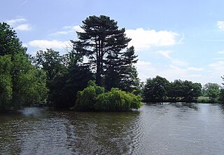
Rose Isle is an island in the River Thames in England just downstream of Kennington Railway Bridge on the reach above Sandford Lock, near Kennington, Oxfordshire.

Castle Mill Stream is a backwater of the River Thames in the west of Oxford, England. It is 5.5 km long.
Sandford St Martin is a village and civil parish in West Oxfordshire about 7 miles (11 km) east of Chipping Norton and about 12 miles (19 km) south of Banbury. The 2011 Census recorded the parish's population as 209.
Deans Brook is a two-kilometre-long stream which runs between Mill Hill and Edgware in the London Borough of Barnet. It is a tributary of the Silk Stream, which is a tributary of the River Brent, which is a tributary of the River Thames.

Letcombe Brook is a 7.5-mile (12 km) stream in the Vale of White Horse in Oxfordshire, England. It rises at the foot of the Berkshire Downs in Letcombe Bassett and flows through Letcombe Regis, Wantage, Grove and East Hanney to join Childrey Brook, which is a tributary of the River Ock, which is a tributary of the River Thames.

Edgwarebury Brook is a small stream in Edgware in the London Borough of Barnet. It is a tributary of Deans Brook, which is a tributary of the Silk Stream, which is a tributary of the River Brent, which is a tributary of the River Thames.

Littlemore Hospital was a mental health facility on Sandford Road in Littlemore, Oxfordshire.

Dry Sandford Pit is a 4.2-hectare (10-acre) biological and geological Site of Special Scientific Interest north-west of Abingdon-on-Thames in Oxfordshire. It is a Geological Conservation Review site and it is managed as a nature reserve by the Berkshire, Buckinghamshire and Oxfordshire Wildlife Trust.
