
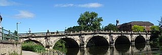
Llandeilo Bridge (Welsh: Pont Llandeilo) is a Grade II* listed road bridge crossing the River Towy in Llandeilo, Carmarthenshire, Wales. It carries the main A483 road towards Ffairfach. [1]
Llandeilo Bridge (Welsh: Pont Llandeilo) is a Grade II* listed road bridge crossing the River Towy in Llandeilo, Carmarthenshire, Wales. It carries the main A483 road towards Ffairfach. [1]
The single-arch bridge was designed by Llandeilo's [1] William Williams, the county bridge surveyor, and built between 1843 and 1848. [2] It replaced a previous three-arched bridge over the river than had, in turn, replaced the medieval seven-arch bridge which had collapsed in 1795. [2] The construction logistics defeated Williams' builder, Morgan Morgan, who was sacked after the entire budget of £6000 was spent building the difficult foundations. [2] Williams died before the bridge was completed and, in 1846, Edward Haycock took over the project. It eventually cost a massive £23,000. [2]

The earlier bridge had been criticised as not even wide enough for a horse and cart, [2] therefore the new bridge was wide enough for a double carriageway. A single arch spanned 143 ft (43m) across the river, [1] rising 35 ft (10.5m) above it [3] (at the time it was the third longest single arch in Britain). The height of the bridge essentially reduced the gradient of the road towards the town. [2] The bridge, arch soffits, parapets and buttresses are faced with chisel- or hammer-dressed masonry, while the voussoirs of the arch are lengthy and finished with ashlar. [3] Large stone buttresses marked each end of the arch, and similar buttresses continued in either direction from the bridge supporting the long causeways towards Llandeilo and Ffairfach. [1]

Carmarthenshire is a county in the south-west of Wales. The three largest towns are Llanelli, Carmarthen and Ammanford. Carmarthen is the county town and administrative centre. The county is known as the "Garden of Wales" and is also home to the National Botanic Garden of Wales.

Carmarthen is the county town of Carmarthenshire and a community in Wales, lying on the River Towy 8 miles (13 km) north of its estuary in Carmarthen Bay. The population was 14,185 in 2011, down from 15,854 in 2001, but gauged at 16,285 in 2019. It has a claim to be the oldest town in Wales – Old Carmarthen and New Carmarthen became one borough in 1546. It was the most populous borough in Wales in the 16th–18th centuries, described by William Camden as "chief citie of the country". Growth stagnated by the mid-19th century as new settlements developed in the South Wales Coalfield.

Llandeilo is a town and community in Carmarthenshire, Wales, situated at the crossing of the River Towy by the A483 on a 19th-century stone bridge. Its population was 1,795 at the 2011 Census. It is adjacent to the westernmost point of the Brecon Beacons National Park. The town is served by Llandeilo railway station on the Heart of Wales Line.

Llandovery is a market town and community in Carmarthenshire, Wales. It lies on the River Tywi and at the junction of the A40 and A483 roads, about 25 miles (40 km) north-east of Carmarthen, 27 miles (43 km) north of Swansea and 21 miles (34 km) west of Brecon.
The English Bridge is a masonry arch viaduct, crossing the River Severn in Shrewsbury, Shropshire. The present bridge is a 1926 rebuilding and widening of John Gwynn's design, completed in 1774. A bridge is known to have stood at this spot since at least Norman times. Historically, it was known as the "Stone Bridge". It is a Grade II* listed building.

Dinefwr Castle is a ruined castle overlooking the River Towy near the town of Llandeilo, Carmarthenshire, Wales. It lies on a ridge on the northern bank of the Towy, with a steep drop of one hundred feet to the river. Dinefwr was the chief seat of the Dinefwr dynasty of the Kingdom of Deheubarth. The castle is a Grade I listed building.

The Afon Cennen is a river in the county of Carmarthenshire, south Wales. It rises on the northern slopes of the Black Mountain to the east of the summit of Tair Carn Uchaf and flows north to Blaencennen Farm, then westwards past Carreg Cennen Castle, continuing through the village of Trap where it exits the Brecon Beacons National Park. Near the hamlet of Derwydd it turns northwest for a mile then northeast to run through the village of Ffairfach to its confluence with the River Towy opposite Llandeilo.
Trap is a hamlet in the county of Carmarthenshire in southwest Wales, located on the western border of the Brecon Beacons National Park, around four miles southeast of the town of Llandeilo. It is unclear whether the name – which often appears as Trapp on maps, although the spelling with a single p is generally preferred locally – refers to a fish-trap, a water-trap (mill-leat), or, given that the village is in Cwm Lladron, an ambush point.

The Old Bridge, which is now also known as the William Edwards Bridge or Pontypridd Bridge, was originally known as the New Bridge or Newbridge, is an arched single-span footbridge that spans the River Taff at Pontypridd in Wales. The bridge was built by William Edwards and was completed in 1756. The bridge now has statutory protection as a scheduled ancient monument and is grade I listed.
Ffairfach is a village one-half mile (0.80 km) south of the market town of Llandeilo in the eastern part of Carmarthenshire, Wales. It is close to the confluence of the Afon Cennen and the River Towy. Population is 516 according to 2017 census.
Horkstow Bridge is a suspension bridge that spans the New River Ancholme near the village of Horkstow in North Lincolnshire. It was designed by Sir John Rennie as part of the River Ancholme Drainage Scheme, completed in 1836, and is a Grade II* listed building.

The Westgate area of Gloucester is centred on Westgate Street, one of the four main streets of Gloucester and one of the oldest parts of the city. The population of the Westgate ward in Gloucester was 6,687 at the time of the 2011 Census.

Dolauhirion Bridge is a single arch stone bridge which carries road traffic from Llandovery to Cilycwm over the River Towy in Carmarthenshire, Wales. It is a grade I listed structure. At the time the bridge was built the road was the main coach road from Llandovery to Lampeter.

Crickhowell Bridge is an 18th-century bridge that spans the River Usk in Crickhowell, Powys, Wales. The main A4077 road to Gilwern crosses it. The bridge is claimed to be the longest stone bridge in Wales at over 128 metres (420 ft).

Llangynidr Bridge, also known as "Coed-yr-Ynys Bridge", is an early 18th-century bridge that crosses the River Usk to the north of Llangynidr, Powys, Wales. It carries the B4560 road towards Bwlch.

Carmarthen Bridge is the modern 1930s road bridge crossing the River Tywi in Carmarthen, Wales, carrying the A484 road.
Cenarth Bridge, also spelt Kenarth Bridge, is a three arch bridge which spans the River Teifi at Cenarth, Carmarthenshire in Wales. The bridge was built between 1785 and 1787 and designed by David Edwards, the son of William Edwards who built the Old Bridge at Pontypridd. The bridge straddles the border between Carmarthenshire and Ceredigion. It is both a Grade II* listed structure and a scheduled monument.

Thomas Thomas was a Welsh church minister and chapel architect, also known as Thomas Glandŵr. He is described as "the first national architect of Wales" and the "unchallenged master of chapel architecture in Wales in the 1860s".

Llawhaden Bridge is a Grade II* listed medieval stone arch bridge spanning the Eastern Cleddau river near Llawhaden village in Pembrokeshire, Wales, in the community of Llawhaden and about 1 mile (1.6 km) upstream of the river's tidal limit at Canaston Bridge. It is a scheduled ancient monument.