
Llanfyrnach Rural District was an administrative division of Pembrokeshire, Wales.
Llanfyrnach Rural District was an administrative division of Pembrokeshire, Wales.
Llanfyrnach Rural District Council was created in 1894 from the part of Newcastle in Emlyn Poor Law Union situated in Pembrokeshire and consisted of six civil parishes: Capel Colman, Castellan, Clydau, Llanfyrnach, Penrydd, and West Cilrhedyn. It continued to be administered by Newcastle Emlyn. [1]
The Council comprised councillors and a chairman, and its responsibilities included sanitary services, sewerage, refuse collection, maintaining local roads, cemeteries, and parks, licensing of public entertainments, water supply, and housing. It became a rating authority in 1925. Rural District Councils were administered by a number of committees and by appointed officers, including a clerk, treasurer, public health inspector, housing officer, surveyor and rating officer. [1]
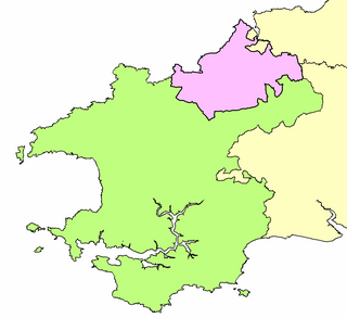
The Council was abolished in 1934, when it was amalgamated with St Dogmells RD to form Cemaes RD (which itself was abolished in 1974 following local government reorganisation and its functions were assumed by Preseli Pembrokeshire District Council). [1]
The records of the Council are held by Pembrokeshire Record Office in Haverfordwest. [1]

Carmarthenshire is a county in the south-west of Wales. The three largest towns are Llanelli, Carmarthen and Ammanford. Carmarthen is the county town and administrative centre. The county is known as the "Garden of Wales" and is also home to the National Botanic Garden of Wales.
Eton Rural District was a rural district in the administrative county of Buckinghamshire, England, covering an area in the south-east of the county. It was named after but did not contain Eton, which was an urban district.

Carmarthen District Council was one of six local government districts of the county of Dyfed, west Wales, from 1974 to 1996.
Gloucester was, from 1894 to 1974, a rural district in the administrative county of Gloucestershire, England. The district did not include the City of Gloucester, which was a separate county borough. In 1935, Gloucester RD was more than doubled in size.
Long Crendon was a rural district in the administrative county of Buckinghamshire, England from 1894 to 1934.

Goathurst is a small village and civil parish in the English county of Somerset, around 3 miles from the town of Bridgwater. The parish includes the hamlets of Andersfield and Huntstile. The village is on the route of the Samaritans Way South West.

The Newport district is a principal area of Wales, it was one of the five local government districts of Gwent from 1974 to 1996. The district comprised the county borough of Newport and several surrounding parishes. It inherited the borough status of the former authority and was therefore styled as the Borough of Newport.

Preseli Pembrokeshire was one of six local government districts of Dyfed in West Wales from 1974 to 1996. Until 1987 the name of the district was Preseli. The district took its name from the Preseli Hills.
Magor and St Mellons Rural District was created on 1 April 1935 from Magor Rural District and St Mellons Rural District in the administrative county of Monmouthshire. The district was a mixture of suburban and semi-rural parishes around Newport and had its headquarters in Baneswell, Newport.
St Mellons Rural District is a defunct district council. It was established under the provisions of the Local Government Act 1894 from part of the existing Newport Rural Sanitary District. It comprised the parishes of Bedwas, Bettws, Coedkernew, Duffryn, Graig, Henllys, Machen Lower, Machen Upper, Malpas, Marshfield, Michaelstone-y-Fedw, Peterstone Wentloog, Rogerstone, Rumney, St Brides Wentloog, St Mellons and St Woolos in the administrative county of Monmouthshire. Initially, the St Mellons Rural District Council also administered two parishes in Glamorgan: Llanvedw and Rhydygwern, which had also formed part of the sanitary district. The Glamorgan parishes were annexed to Llandaff and Dinas Powis Rural District in 1895.

Gelligaer is a community in the County Borough of Caerphilly, Wales, in the Rhymney River valley. As well as the village of Gelligaer, the community also includes the small towns of Hengoed and Ystrad Mynach. The population of the community at the 2011 census was 18,408.

Cemaes Rural District was an administrative subdivision of Pembrokeshire, Wales from 1934 to 1974.
St Dogmells was a rural district in the administrative county of Pembrokeshire, Wales from 1894 to 1934.
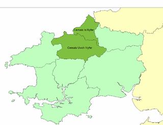
Cemais Uwch Nyfer was a mediaeval Welsh commote in the Dyfed cantref of Cemais, in what is now Pembrokeshire. It consisted of the territory between the Afon Nyfer and Fishguard, and its civil headquarters were at Newport.
Chepstow Rural District was a rural district in the administrative county of Monmouthshire, Wales. It was established under the Local Government Act 1894, and was abolished in 1974 when its functions were assumed by the new Monmouth District Council.
Ceredigion District Council was one of six district-level authorities in the county of Dyfed, Wales, from 1974 until 1996. The district had an identical area to the pre-1974 administrative county of Cardiganshire. From its creation in 1974 the district used the name "Ceredigion" rather than "Cardiganshire", which had been used for the former county council. Further local government reorganisation in 1996 saw Dyfed County Council abolished and Ceredigion become a unitary authority, with the district council taking over county-level services to become Ceredigion County Council.

Cemaes Head is a headland and nature reserve in north Pembrokeshire. It lies in the community of St Dogmaels, within the Pembrokeshire Coast National Park. To the west and north it overlooks Cardigan Bay, and to the east Cardigan Island and the estuary of the River Teifi.
Haverfordwest Rural District was a rural district in the administrative county of Pembrokeshire, Wales from 1894 to 1974, covering an area in the west of the county. It surrounded, but did not include, the town of Haverfordwest after which it was named.
Pembroke Rural District was a rural district in the administrative county of Pembrokeshire, Wales from 1894 to 1974, covering an area in the south of the county. It surrounded, but did not include, the town of Pembroke after which it was named.
Narberth Rural District was a rural district in the administrative county of Pembrokeshire, Wales from 1894 to 1974, covering an area in the east of the county.