Gloucester is a cathedral city and the county town of Gloucestershire in the South West of England. Gloucester lies on the River Severn, between the Cotswolds to the east and the Forest of Dean to the west; it is sited 19 miles (31 km) from Monmouth, 33 miles (53 km) from Bristol, and 17 miles (27 km) east of the border with Wales. Gloucester has a population of around 132,000, including suburban areas. It is a port, linked via the Gloucester and Sharpness Canal to the Severn Estuary.

The Herefordshire and Gloucestershire Canal is a canal in the west of England, which ran from Hereford to Gloucester, where it linked to the River Severn. It was opened in two phases in 1798 and 1845, and closed in 1881, when the southern section was used for the course of the Ledbury and Gloucester Railway. It is the subject of an active restoration scheme.
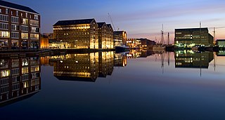
The Gloucester and Sharpness Canal is a ship canal in the west of England, between Gloucester and Sharpness, completed in 1827. For much of its length the canal runs close to the tidal River Severn, but it cuts off a significant loop in the river, at a once-dangerous bend near Arlingham. It was once the broadest and deepest canal in the world. The canal is 26.5 km long.

Brockworth is a village and parish in the Borough of Tewkesbury, Gloucestershire, England, situated on the old Roman road that connects the City of Gloucester with Barnwood. It is located 4 miles (6.4 km) southeast of central Gloucester, 6 miles (9.7 km) southwest of Cheltenham and 11.5 miles (18.5 km) north of Stroud. The population taken at the 2011 census was 7,387. The population increased to 9,422 at the 2021 Census.

The A419 road is a primary route between Chiseldon near Swindon at junction 15 of the M4 with the A346 road, and Whitminster in Gloucestershire, England near the M5 motorway. The A419 is managed and maintained by a private company, Road Management Group, on behalf of the UK Department for Transport.

The A417 is a main road in England, running from Streatley, Berkshire to Hope under Dinmore, Herefordshire. It is best known for its section between Cirencester and Gloucester where it has primary status and forms part of the link between the major settlements of Swindon and Gloucester.
Monks Park is a northern suburb of the city of Bristol, England, and is the highest point within the city. Monks Park stretches westward, towards Southmead, from the A38 trunk road. Filton Park lies directly north, on the South Gloucestershire side of the city boundary. Horfield lies to the east of the A38 and also to the south.

Llanthony Secunda Priory was a house of Augustinian canons in the parish of Hempsted, Gloucestershire, England, situated about 1/2 a mile south-west of Gloucester Castle in the City of Gloucester. It was founded in 1136 by Miles de Gloucester, 1st Earl of Hereford, a great magnate based in the west of England and the Welsh Marches, hereditary Constable of England and Sheriff of Gloucestershire, as a secondary house and refuge for the canons of Llanthony Priory in the Vale of Ewyas, within his Lordship of Brecknock in what is now Monmouthshire, Wales. The surviving remains of the Priory were designated as Grade I listed in 1952 and the wider site is a scheduled ancient monument. In 2013 the Llanthony Secunda Priory Trust received funds for restoration work which was completed in August 2018 when it re-opened to the public.

Purton is a village on the east bank of the River Severn, 3 miles north of Berkeley, in Gloucestershire, England. The village is in the civil parish of Hinton. It lies opposite the hamlet of Purton on the west bank of the river.
Kilpeck Priory was a Benedictine priory in Kilpeck, Herefordshire, England, at grid reference SO448303.

The Westgate area of Gloucester is centred on Westgate Street, one of the four main streets of Gloucester and one of the oldest parts of the city. The population of the Westgate ward in Gloucester was 6,687 at the time of the 2011 Census.
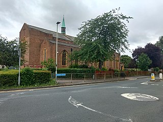
Holy Trinity Church is a Grade II listed Church of England parish church in Longlevens, Gloucester. It was designed by Harold Stratton Davis and built in 1933–1934 in a fifteenth-century perpendicular Gothic style. It includes German and Dutch stained glass that was transferred from the Church of St Luke, High Orchard, Gloucester, after that church was demolished in 1934.

The Church of St Luke, High Orchard, Gloucester, was a Church of England church built and endowed by the Reverend Samuel Lysons, rector of Rodmarton, who was also the first minister.

High Orchard was an industrial area of the city of Gloucester in England that was developed in the 19th century on the former orchard of the Priory of Llanthony Secunda (1136). The area was closely associated with Gloucester Docks immediately to the north, and served by the Gloucester and Sharpness Canal and railway transport. It was the site of Fielding & Platt's Atlas Works and a number of other significant local employers.
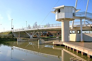
High Orchard Bridge is a bascule bridge over the Gloucester and Sharpness Canal in High Orchard in the city of Gloucester, England. It was opened in 2008 to carry the newly constructed St Ann Way over the canal. In 2012, Marstons pub company opened a brand new pub on the land next to the bridge and named it after the bridge “The High Orchard” which has since gone on to be one of Gloucester’s busiest pubs.

Bristol Road in the City of Gloucester dates from the medieval period. It runs between Southgate Street in the north and Quedgeley in the south where it joins the Bath Road and the A38. It contains a number of listed buildings and other notable structures.

Southgate Street is one of the ancient streets in the City of Gloucester, so named because its southern end was originally the location of the south gate in the city's walls. The part beyond the gate as far as Severn Street was sometimes known as Lower Southgate Street. It runs from the crossroads of Northgate, Eastgate, Southgate, and Westgate Streets in the north to Bristol Road in the south.
St Kyneburgh's Chapel was established in early times near the City of Gloucester. It was dedicated to St Kyneburgh and was transferred with all its lands to Llanthony Secunda Priory by Roger Earl of Hereford between 1143 and 1155. It was situated inside Gloucester's city wall at the south gate. It was formerly a possession of St Owen's Church, Gloucester.

Spa Road in the City of Gloucester runs between the junction of Southgate Street and Llanthony Road in the north and Montpellier in the South. It is joined by Brunswick Road on its north side. It contains a number of listed buildings.

 Llanthony Road Bridge looking east along Llanthony Road
 Llanthony Road Bridge looking north
