Lluta River

Last updated
Lluta River
Arica022.jpg
Lluta Valley as seen from Chile Route 11
Location
Country Chile
Physical characteristics
Source 
  elevation3,900 m (12,800 ft)
Mouth  
  location
Pacific Ocean
Length147 km (91 mi)
Basin size3,400 km2 (1,300 sq mi)
Discharge 
  average2.3 m3/s (81 cu ft/s)

The Lluta River is a river located in the northern portion of the Arica y Parinacota Region of Chile. Its headwaters are on the western flanks of the Andes of the Parinacota Province, just a few kilometers south of the border with Peru, and empties into the Pacific Ocean at the village of Villa Frontera, about 4 km north of the city of Arica.

Contents

Course

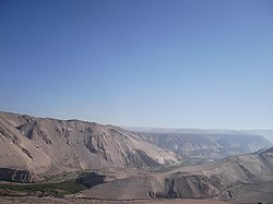
The Lluta originates at the confluence of the Quebrada Caracarani (which rises from the slopes of the Tacora volcano) and the Azufre River, at an elevation about 3,900 m asl. Along its first 36 km, the river flows southeast and then slowly begins to turn towards the west. In its descent to the lower elevations of the valley, the river starts to run through a canyon carved by the same river in rhyolite tuffs and other sediments scarcely joined.

In the vicinity of Socoroma, the river turns directly west and just past the canyon terminus, the river begins to widen. In Chironta, about 70 km from the sea, appear the first farms, whose foods are of a great importance for the consume of local people. Finally, the river empties into Pacific Ocean at an extensive beach, just a few kilometers north of Arica.

The hydrologic regime of the river basin is rain-dominated. The increase of its water volume occurs mainly in January and February, as a consequence of the phenomenon known as Bolivian Winter.

Under the Chilean proposal of 1975 to resolve the Atacama border dispute, the Lluta River would have become the northern border of Chile, and Bolivia would control the narrow strip between the river and the southern border of Peru.

Water quality

Apart from its problems of salinity and acidity, the river has very elevated levels of boron, arsenic, and sulfate, among other pollutants, which restricts the agricultural activities that can be developed along the river banks. [1] The river water is used only for irrigation of pastureland and crops which tolerate poor water quality, such as onions and potatoes. [1]

Related Research Articles

Tacna Place in Peru

Tacna is a city in southern Peru and the regional capital of the Tacna Region. A very commercially active city, it is located only 35 km (22 mi) north of the border with Arica y Parinacota Region from Chile, inland from the Pacific Ocean and in the valley of the Caplina River. It is Peru's tenth most populous city.

Atacama border dispute Border dispute between Bolivia and Chile

The Atacama border dispute is a dispute between Chile and Bolivia that stems from the transfer of the Bolivian Coast and the southern tip of Peru to Chile in the 19th century through the Treaty of Ancón with Peru and the Treaty of Peace and Friendship of 1904 between Chile and Bolivia after the War of the Pacific (1879–1883). The dispute is considered to be ongoing because Bolivia still claims a sovereign access to the Pacific Ocean. The conflict takes its name from the Atacama Desert on which lies the disputed territory. Due to a transfer of land to both Argentina and Chile during the Chilean annexation of the Bolivian coast in 1879, the Puna de Atacama dispute—this spin-off dispute was settled in 1899.

Department of Tacna Departments of Peru

Tacna is the southernmost department and region in Peru. The Chilean Army occupied the present-day Tacna Department during the War of the Pacific from 1885 to 1929 when it was reincorporated into Peruvian soil.

Arica Province Province in Arica y Parinacota, Chile

Arica Province is one of two provinces of Chile's northernmost region, Arica y Parinacota. The province is bordered on the north by the Tacna Province of Peru, on the south by the Tamarugal Province in the Tarapacá Region, on the east the Parinacota Province and on the west by the Pacific Ocean. Its capital is the port city of Arica.

Arica City and Commune in Arica y Parinacota, Chile

Arica is a commune and a port city with a population of 222,619 in the Arica Province of northern Chile's Arica y Parinacota Region. It is Chile's northernmost city, being located only 18 km (11 mi) south of the border with Peru. The city is the capital of both the Arica Province and the Arica and Parinacota Region. Arica has a mild, temperate climate with some of the lowest annual rainfall rates anywhere in the world. Arica is located at the bend of South America's western coast known as the Arica Bend or Arica Elbow. At the location of the city are two lush valleys that dissect the Atacama Desert converge: Azapa and Lluta. These valleys provide fruit for export.

Tarapacá Region Region of Chile

The Tarapacá Region is one of Chile's 16 first-order administrative divisions. It comprises two provinces, Iquique and Tamarugal. It borders the Chilean Arica and Parinacota Region to the north, Bolivia's Oruro Department and Potosí Department on the east, Chile's Antofagasta Region to the south and the Pacific Ocean to the west. The port city of Iquique is the region's capital.

Arica y Parinacota Region Region of Chile

The Arica y Parinacota Region is one of Chile's 16 first order administrative divisions. It comprises two provinces, Arica and Parinacota. It borders Peru's Department of Tacna to the north, Bolivia's La Paz and Oruro departments to the east and Chile's Tarapacá Region to the south. Arica y Parinacota is the 5th smallest, the 3rd least populous and the 6th least densely populated of the regions of Chile. Arica is the region's capital and largest city.

Tacora Stratovolcano in Parinacota Province, Chile

Tacora is a stratovolcano located in the Andes of the Arica y Parinacota Region of Chile. Near the border with Peru, it is one of the northernmost volcanoes of Chile. It is part of the Central Volcanic Zone in Chile, one of the four volcanic belts of the Andes. The Central Volcanic Zone has several of the highest volcanoes in the world. Tacora itself is a stratovolcano with a caldera and a crater. The youngest radiometric age is 50,000 years ago and it is heavily eroded by glacial activity.

Lauca River River in Bolivia and Chile

The Lauca River is a binational river. It originates in the Chilean Altiplano of the Arica and Parinacota Region, crosses the Andes and empties into Coipasa Lake in Bolivia.

Cotacotani Lake

Laguna de Cotacotani or Quta Qutani is a lake located in the Andean Altiplano of the Parinacota Province, Arica-Parinacota Region, Chile. It lies 4 km northwest of Chungará Lake, which is one of the highest lakes in the world and is surrounded by several volcanoes, such as the Payachata volcanic group, Sajama volcano and Wallatiri.

Arica Province (Peru)

The Province of Arica was a historical territorial division of Peru, which existed between 1823 and 1883. It was populated by pre-Hispanic peoples for a long period of time before Spanish colonisation in the early 16th century saw the transformation of a small town into a thriving port. Trade in both gold and silver was facilitated through Arica after the precious metals were first extracted from the Potosí silver mines of Bolivia. Following the War of the Pacific, the province was transferred to Chile and became an official Chilean territory in 1929.

Tarapacá Department (Peru)

The Tarapacá Department was an old territorial division of Peru, which existed between 1878 and 1884, when it was unconditionally ceded to Chile after the War of the Pacific under the Treaty of Ancón.

Treaty of Peace and Friendship (1904) 1904 border demarcation treaty between Chile and Bolivia

The Treaty of Peace and Friendship of 1904 between Chile and Bolivia was signed in Santiago de Chile on October 20, 1904, to delineate the boundary through 96 specified points between Cerro Zapaleri and Cerro Chipe and to regulate the relations between the two countries 20 years after the end of the War of the Pacific.

Cosapilla River

The Cosapilla River is a river of Chile and Bolivia and is part of the boundary. It is also called Caquena and, in Bolivia, Cosapa. From its source in the Parinacota Province, the river flows north, is part of the Chile-Bolivia boundary and then flows in the Bolivian Department of Oruro.

Villa Frontera, also identified as Chacalluta, is a village within the Arica Province of the Arica and Parinacota Region, Chile.

The 1877 Iquique earthquake occurred at 21:16 local time on 9 May. It had a magnitude of 8.5 on the surface wave magnitude scale. Other estimates of its magnitude have been as high as 8.9 Mw and 9.0 Mt. It had a maximum intensity of XI (Extreme) on the Mercalli intensity scale and triggered a devastating tsunami. A total of 2,385 people died, mainly in Fiji.

Kunturiri (Bolivia-Chile)

Kunturiri is a volcano in the Andes on the border of Bolivia and Chile which rises up to 5,762 metres (18,904 ft). On the Chilean side it is located in the Arica and Parinacota Region and on the Bolivian side in the Oruro Department, Sajama Province, Curahuara de Carangas Municipality, Sajama Canton as well as in the La Paz Department, Pacajes Province, Calacoto Municipality, Ulloma Canton.

Lauca is a 5,140 metres (16,860 ft) high andesitic stratovolcano in the Central Volcanic Zone of the Andes on the Altiplano in northern Chile. Administratively it is located in Putre, Arica y Parinacota Region. The volcano was active during the Late Miocene from 10.5 million years ago onwards. A major ignimbrite collapsed the volcano in the Late Pliocene.

Chapiquiña Power Plant Hydroelectric power station in Chile

Chapiquiña power plant is a hydroelectric power plant in northern Chile. It takes water from the Canal Lauca and produces electrical power through a Pelton turbine.

References

  1. 1 2 "Lluta River, Chile". NASA Earth Observatory. 2 November 2013. Retrieved February 6, 2014.

Coordinates: 18°24′55″S70°19′35″W / 18.41528°S 70.32639°W / -18.41528; -70.32639