The Gambia is divided into eight local government areas. They are:
The Gambia is divided into eight local government areas. They are:
| Local Government Areas | |||||||||||||
|---|---|---|---|---|---|---|---|---|---|---|---|---|---|
| National capital, Divisions and Districts |
| ||||||||||||
| | This Gambian location article is a stub. You can help Wikipedia by expanding it. |

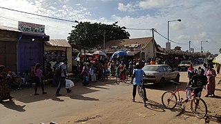
The Gambia, officially the Republic of The Gambia, is a country in West Africa. It is the smallest country within mainland Africa and is surrounded by Senegal, except for its western coast on the Atlantic Ocean. The Gambia is situated on both sides of the lower reaches of the Gambia River, the nation's namesake, which flows through the centre of the Gambia and empties into the Atlantic Ocean, thus the long shape of the country. It has an area of 10,689 square kilometres (4,127 sq mi) with a population of 1,857,181 as of the April 2013 census. Banjul is the Gambian capital and the country's largest metropolitan area, while the largest cities are Serekunda and Brikama.
The first written records of the region come from Arab traders in the 9th and 10th centuries. In medieval times, the region was dominated by the Trans-Saharan trade and was ruled by the Mali Empire. In the 16th century, the region came to be ruled by the Songhai Empire. The first Europeans to visit the Gambia River were the Portuguese in the 15th century, in 1445, who attempted to settle on the river banks, but no settlement of significant size was established. Descendants of the Portuguese settlers remained until the 18th century. In the late 16th century, English merchants attempted to begin a trade with the Gambia, reporting that it was "a river of secret trade and riches concealed by the Portuguese."

Senegambia, officially the Senegambia Confederation or Confederation of Senegambia, was a loose confederation in the late 20th century between the West African countries of Senegal and its neighbour the Gambia, which is almost completely surrounded by Senegal. The confederation was founded on 1 February 1982 following an agreement between the two countries signed on 12 December 1981. It was intended to promote cooperation between the two countries, but was dissolved by Senegal on 30 September 1989 after the Gambia refused to move closer toward union. The Senegambia Confederation should not be confused with the historic Senegambia region, generally shortened to the Senegambia.

Basse Santa Su, usually known as Basse, is a town in the Gambia, lying on the south bank of the River Gambia. The easternmost major town in the nation, it known for its important market. Basse is the capital of the Upper River Division, which is coterminous with the Basse Local Government Area. As of 2009, the town has an estimated population of 18,414. According to the 2013 census, the Basse LGA has 243,791 residents.

Janjanbureh or Jangjangbureh is a town, founded in 1832, on Janjanbureh Island, also known as MacCarthy Island, in the Gambia River in eastern Gambia. Until 1995, it was known as Georgetown and was the second largest town in the country. It is the capital of Janjanbureh Local Government Area, and the Janjanbureh district. The population of the Janjanbureh LGA was 127,333 at the 2013 population census.
Brikama is one of the largest cities in the Gambia. It is also called 'Satey Ba' by the locals, meaning "big town". It lies southwest of the country's capital, Banjul. Brikama is the headquarters of the Brikama Local Government Area, and is the largest city in the region containing over twenty five wards with a population of over 100,000. As per the 2013 census, the population of Brikama LGA is 730,895.
Kanifing is a town in the Gambia, and lies immediately west of the capital city of Banjul.

Lower River Division is one of the five administrative divisions of the Gambia. Its capital is Mansa Konko. The city and area council elections were held during April 2002, when Wally S.M. Sanneh, an APRC candidate became the Mayor, winning unopposed. The council was led by Alliance for Patriotic Reorientation and Construction (APRC), which won all the 12 seats.

Central River is the largest of the five administrative divisions of the Gambia. Its capital is Janjanbureh, on MacCarthy Island. The largest settlement is Bansang, with an estimated population in 2008 of 8,381.

North Bank was one of the five administrative divisions of the Gambia. Its capital was Kerewan. It was subsequently reorganised as the Kerewan Local Government Area (LGA), without any change in the area covered.

Upper River was one of the five Divisions of the Gambia. Its capital was Basse Santa Su. It was subsequently reorganised as the Basse Local Government Area, without any change in the area covered.

West Coast Region, originally the Western Division, also known as Foni or Fonyi, was one of the five administrative divisions of the Gambia. Its capital was Brikama. It was subsequently reorganised as the Brikama Local Government Area (LGA), without any change in the area covered.
Kuntaur is a town located in central part of the Gambia.
The Gambia is subdivided into 43 districts. They are listed below by Local Government Area, each with its population at the 15 April 2013 census.

The Gambia is divided into five administrative Regions and one City. The divisions of the Gambia are created by the Independent Electoral Commission in accordance to Article 192 of the National Constitution.
A local government area (LGA) is an administrative division of a country that a local government is responsible for. The size of an LGA varies by country but it is generally a subdivision of a state, province, division, or territory.
Kombo North/Saint Mary is one of the nine districts of the Gambia's Brikama Local Government Area, which is located to the south of the Gambia River in the southwest of the country. Kombo North/Saint Mary is in the northwest of the LGA, between Kombo South and Kanifing LGA. It is the only district in the LGA with coasts on both the Atlantic Ocean and the Gambia River, and is the most populated district in the LGA, with 344,756 inhabitants at the 2013 Census.

Fulladu East was one of the four districts of the Upper River Division of the Gambia. The Upper River Division is now the Basse Local Government Area, and the former Fulladu East District is now divided into a Basse Fulladu East District, a Jimara District and a Tumana District.

The Gambia Colony and Protectorate was the British colonial administration of the Gambia from 1821 to 1965, part of the British Empire in the New Imperialism era. The colony was the immediate area surrounding Bathurst, and the protectorate was the inland territory situated around the Gambia River, which was declared in 1894.