
The Global Positioning System (GPS), originally Navstar GPS, is a satellite-based radio navigation system owned by the United States government and operated by the United States Space Force. It is one of the global navigation satellite systems (GNSS) that provides geolocation and time information to a GPS receiver anywhere on or near the Earth where there is an unobstructed line of sight to four or more GPS satellites. It does not require the user to transmit any data, and operates independently of any telephonic or Internet reception, though these technologies can enhance the usefulness of the GPS positioning information. It provides critical positioning capabilities to military, civil, and commercial users around the world. Although the United States government created, controls and maintains the GPS system, it is freely accessible to anyone with a GPS receiver.

Galileo is a global navigation satellite system (GNSS) that went live in 2016, created by the European Union through the European Space Agency (ESA), operated by the European Union Agency for the Space Programme (EUSPA), headquartered in Prague, Czechia, with two ground operations centres in Fucino, Italy, and Oberpfaffenhofen, Germany. The €10 billion project is named after the Italian astronomer Galileo Galilei. One of the aims of Galileo is to provide an independent high-precision positioning system so European political and military authorities do not have to rely on the US GPS, or the Russian GLONASS systems, which could be disabled or degraded by their operators at any time. The use of basic (lower-precision) Galileo services is free and open to everyone. A fully encrypted higher-precision service is available for free to government-authorized users. Galileo is intended to provide horizontal and vertical position measurements within 1 m precision. Galileo is also to provide a new global search and rescue (SAR) function as part of the MEOSAR system.

Loran-C is a hyperbolic radio navigation system that allows a receiver to determine its position by listening to low frequency radio signals that are transmitted by fixed land-based radio beacons. Loran-C combined two different techniques to provide a signal that was both long-range and highly accurate, features that had been incompatible. Its disadvantage was the expense of the equipment needed to interpret the signals, which meant that Loran-C was used primarily by militaries after it was introduced in 1957.

The BeiDou Navigation Satellite System is a Chinese satellite navigation system. It consists of two separate satellite constellations. The first BeiDou system, officially called the BeiDou Satellite Navigation Experimental System and also known as BeiDou-1, consisted of three satellites which, beginning in 2000, offered limited coverage and navigation services, mainly for users in China and neighboring regions. BeiDou-1 was decommissioned at the end of 2012. The second generation of the system, officially called the BeiDou Navigation Satellite System (BDS) and also known as COMPASS or BeiDou-2, became operational in China in December 2011 with a partial constellation of 10 satellites in orbit. Since December 2012, it has been offering services to customers in the Asia-Pacific region. Within the region, BeiDou is more accurate than GPS.
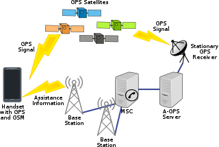
Assisted GNSS (A-GNSS) is a GNSS augmentation system that often significantly improves the startup performance—i.e., time-to-first-fix (TTFF)—of a global navigation satellite system (GNSS). A-GNSS works by providing the necessary data to the device via a radio network instead of the slow satellite link, essentially "warming up" the receiver for a fix. When applied to GPS, it is known as assisted GPS or augmented GPS. Other local names include A-GANSS for Galileo and A-Beidou for BeiDou.

A satellite navigation or satnav system is a system that uses satellites to provide autonomous geopositioning. A satellite navigation system with global coverage is termed global navigation satellite system (GNSS). As of 2023, four global systems are operational: the United States’s Global Positioning System (GPS), Russia's Global Navigation Satellite System (GLONASS), China's BeiDou Navigation Satellite System, and the European Union's Galileo.
GIOVE, or Galileo In-Orbit Validation Element, is the name for two satellites built for the European Space Agency (ESA) to test technology in orbit for the Galileo positioning system.
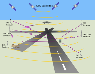
The local-area augmentation system (LAAS) is an all-weather aircraft landing system based on real-time differential correction of the GPS signal. Local reference receivers located around the airport send data to a central location at the airport. This data is used to formulate a correction message, which is then transmitted to users via a VHF Data Link. A receiver on an aircraft uses this information to correct GPS signals, which then provides a standard instrument landing system (ILS)-style display to use while flying a precision approach. The FAA has stopped using the term LAAS and has transitioned to the International Civil Aviation Organization (ICAO) terminology of ground-based augmentation system (GBAS). While the FAA has indefinitely delayed plans for federal GBAS acquisition, the system can be purchased by airports and installed as a Non-Federal navigation aid.

The Quasi-Zenith Satellite System (QZSS), also known as Michibiki (みちびき), is a four-satellite regional satellite navigation system and a satellite-based augmentation system developed by the Japanese government to enhance the United States-operated Global Positioning System (GPS) in the Asia-Oceania regions, with a focus on Japan. The goal of QZSS is to provide highly precise and stable positioning services in the Asia-Oceania region, compatible with GPS. Four-satellite QZSS services were available on a trial basis as of 12 January 2018, and officially started on 1 November 2018. A satellite navigation system independent of GPS is planned for 2023 with seven satellites. In May 2023 it was announced that the system would expand to eleven satellites.
A positioning system is a system for determining the position of an object in space. One of the most well-known and commonly used positioning systems is the Global Positioning System (GPS).
Augmentation of a global navigation satellite system (GNSS) is a method of improving the navigation system's attributes, such as precision, reliability, and availability, through the integration of external information into the calculation process. There are many such systems in place, and they are generally named or described based on how the GNSS sensor receives the external information. Some systems transmit additional information about sources of error, others provide direct measurements of how much the signal was off in the past, while a third group provides additional vehicle information to be integrated in the calculation process.
GPS Block III consists of the first ten GPS III satellites, which will be used to keep the Navstar Global Positioning System operational. Lockheed Martin designed, developed and manufactured the GPS III Non-Flight Satellite Testbed (GNST) and all ten Block III satellites. The first satellite in the series was launched in December 2018.
Global Navigation Satellite System (GNSS) receivers, using the GPS, GLONASS, Galileo or BeiDou system, are used in many applications. The first systems were developed in the 20th century, mainly to help military personnel find their way, but location awareness soon found many civilian applications.

Septentrio N.V. is a designer and manufacturer of high-end multi-frequency GNSS receivers. Its main target is to provide GNSS receiver boards and modules for further system integration by Original Equipment Manufacturers (OEMs). Septentrio's core technology is used in various professional fields such as land and airborne surveying, mobile mapping, machine control, precision agriculture, mining, transport, offshore applications, construction, timing and geodesy etc.

A satellite navigation device, satnav device or satellite navigation receiver is a user equipment that uses one or more of several global navigation satellite systems (GNSS) to calculate the device's geographical position and provide navigational advice. Depending on the software used, the satnav device may display the position on a map, as geographic coordinates, or may offer routing directions.

The UNSW School of Surveying and Geospatial Engineering (SAGE), part of the UNSW Faculty of Engineering, was founded in 1970 and disestablished in 2013.
A software GNSS receiver is a Global Navigation Satellite System (GNSS) receiver that has been designed and implemented using software-defined radio.
Inside GNSS (IG) is an international controlled circulation trade magazine and website owned by Gibbons Media and Research LLC. It covers space-based positioning, navigation and timing (PNT) technology for engineers, designers, and policy-makers of global navigation satellite systems (GNSS). In the United States, GNSS is identified mainly with the government-operated Navstar Global Positioning System (GPS). InsideGNSS.com is the complimentary website of online news, events, digital newsletters, and webinars, and archived magazine articles.
NextNav, Inc. is the developer of a 3D geolocation service known as Metropolitan Beacon System (MBS), a wide area location and timing technology designed to provide services in areas where GPS or other satellite location signals cannot be reliably received. MBS consumes significantly less power than GPS and includes high-precision altitude. In the United States, NextNav operates its MBS network over its spectrum licenses in the 920-928 MHz band. The company went public on Nasdaq in October 2021 with a merger with special-purpose acquisition company Spartacus Acquisition Corporation.
Washington Yotto Ochieng is a Kenyan academic who is Head of the Department of Civil and Environmental Engineering at Imperial College London. Previously, he was Head of the Centre for Transport Studies and Co-Director of the Institute for Security Science and Technology(ISST) together with Deeph Chana. Ochieng is a Senior Security Science Fellow in ISST. He also serves as Director of the Engineering Geomatics Group and Chair of Positioning and Navigation Systems.