
Argyll and Bute is one of 32 unitary authority council areas in Scotland and a lieutenancy area. The current Lord-Lieutenant for Argyll and Bute is Jane Margaret MacLeod. The administrative centre for the council area is in Lochgilphead at Kilmory Castle, a 19th-century Gothic Revival building and estate. The current Council leader is Councillor Robin Currie, a councillor for Kintyre and the Islands.

Dunoon is the main town on the Cowal peninsula in the south of Argyll and Bute, Scotland. It is located on the western shore of the upper Firth of Clyde, to the south of the Holy Loch and to the north of Innellan. As well as forming part of the council area of Argyll and Bute, Dunoon also has its own community council. Dunoon was a burgh until 1976.

Lochgilphead is a town and former burgh in Argyll and Bute, Scotland, United Kingdom, with a population of around 2,300 people. It is the administrative centre of Argyll and Bute. The village lies at the end of Loch Gilp and lies on the banks of the Crinan Canal. Lochgilphead sits on the A83, with Ardrishaig 2 miles (3 km) to the south and Inveraray 24 miles (39 km) to the north-east; Oban lies 37 miles (60 km) north on the A816.

The County of Bute, also known as Buteshire, is a historic county and registration county of Scotland.

Argyll, sometimes called Argyllshire, is a historic county and registration county of western Scotland.
The Isle of Bute, known as Bute, is an island in the Firth of Clyde in Scotland, United Kingdom. It is divided into highland and lowland areas by the Highland Boundary Fault.

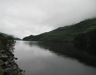
Loch Long is a body of water in Argyll and Bute, Scotland. The Sea Loch extends from the Firth of Clyde at its southwestern end. It measures approximately 20 miles (32 km) in length, with a width of between 1 and 2 miles. The loch also has an arm, Loch Goil, on its western side.

Ardrishaig is a coastal village on Loch Gilp, at the southern (eastern) entrance to the Crinan Canal in Argyll and Bute in the west of Scotland. It lies immediately to the south of Lochgilphead, with the nearest larger town being Oban.

Tarbert is a village in the west of Scotland, in the Argyll and Bute council area. It is built around East Loch Tarbert, an inlet of Loch Fyne, and extends over the isthmus which links the peninsula of Kintyre to Knapdale and West Loch Tarbert. Tarbert had a recorded population of 1,338 in the 2001 Census.

Ascog is a small village on the Isle of Bute, within Argyll and Bute council area, Scotland. The village is within the parish of Kingarth, and is situated on the A844. It is located on the east coast of the island, about 2 km to the south east of Rothesay. It is largely residential.
Loch Eck is a freshwater loch located on the Cowal peninsula, north of Dunoon, Argyll and Bute, Scotland. It is seven miles long. Along with Loch Lomond, it is the only naturally occurring habitat of the Powan (fish). The loch also has salmon, sea trout, brown trout and arctic charr.

Loch Creran is a sea loch in Argyll, on the west coast of Scotland. It is about 10 kilometres (6.2 mi) long from its head at Invercreran to its mouth on the Lynn of Lorne, part of Loch Linnhe. The loch separates the areas of Benderloch to the south and Appin to the north. The island of Eriska lies at the mouth of the loch. The loch is bridged at its narrowest point at Creagan, by the A828 road. The village of Barcaldine lies on the south shore of the loch.
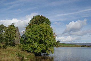
Asgog Loch; is a natural freshwater loch, situated about 4 kilometres (2.5 mi) southwest of Tighnabruaich, on the Cowal peninsula within Argyll and Bute, Scotland, which was dammed to create an impounding reservoir for the supply of freshwater to the Low Mills of the nearby gunpowder mills at Millhouse.
Bishop's Glen Reservoir also known as Dunoon Reservoir used to be the source for drinking water for the town of Dunoon on the Cowal peninsula, Argyll and Bute, Scotland, a function now satisfied via Loch Eck. Records show that this impounding reservoir was created before 1880. The Balgaidh Burn is the main inflow and outflow.

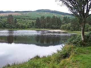
Blackmill Loch is an impounding reservoir, in Argyll and Bute, Scotland. The loch was constructed in 1964 and is one source of freshwater for the Lochgair Hydroelectric Scheme. The loch feeds the River Add, when not diverted for hydroelectric purposes. It is one of the two significant forest lochs to the north of Loch Glashan, the other being Loch Bealach Ghearran.

Cam Loch is one of a number of water supply sources for the Crinan Canal. The impounding reservoir lies to the south of the canal and about 3 kilometres west of Lochgilphead. It has an earthwork dam 8.5 metres high, with records showing that construction was before 1860.
National grid reference NR64128867

Loch Tarsan; is a freshwater loch and impounding reservoir located 13 kilometres Northwest of Dunoon, on the Cowal peninsula in Argyll and Bute, Scotland. This three-armed Reservoir extends into both Glen Tarsan and Glen Lean. It supplies water to the Striven Hydro-Electric Scheme. The larger of the two dams is 17.6 metres high and was completed in 1953. The water that is collected in the loch, are piped to the hydro-electric generating station, located at Ardtaraig, at the head of Loch Striven.
Knockruan Loch is a reservoir of the impounding variety, located 2.5 kilometres north of Campbeltown, Scotland, and is one of three lochs supplying water to the town. The earthfill dam is 1.82 metres high and was completed in 1931.
