
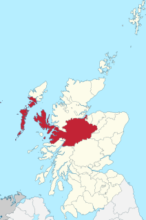
Sutherland is a historic county, registration county and lieutenancy area in the Highlands of Scotland. Its county town is Dornoch. Sutherland borders Caithness and Moray Firth to the east, Ross-shire and Cromartyshire to the south and the Atlantic to the north and west. Like its southern neighbour Ross-shire, Sutherland has some of the most dramatic scenery in Europe, especially on its western fringe where the mountains meet the sea. These include high sea cliffs, and very old mountains composed of Precambrian and Cambrian rocks.

Achanalt is a railway halt in Strath Bran, Ross and Cromarty, in the Scottish council area of Highland. It is served by a railway station on the Kyle of Lochalsh Line from Inverness to Kyle of Lochalsh.

Chno Dearg is a mountain in the Lochaber area of the Scottish Highlands. It overlooks Glen Spean to the north and Loch Treig to the west. With a height of 1,046 metres (3,432 ft), it is classed as a Munro.

Achentoul is a hamlet in the Kinbrace area of Sutherland, in the Scottish council area of Highland. Consisting of a few farmhouses and barns, Achentoul lies around 1.5 miles (2.4 km) north of Kinbrace along the A897 road and south of Loch An Ruathair. Although the Achentoul Forest is located in this area, the landscape is said to be dominated by moist Atlantic heather moor.
Inverness-shire is a historic county, registration county and lieutenancy area of Scotland. Covering much of the Highlands and Outer Hebrides, it is Scotland's largest county, though one of the smallest in population, with 67,733 people or 1.34% of the Scottish population.
Badcall comprises two remote hamlets, called Lower Badcall and Upper Badcall. Upper Badcall, a crofting township, is the larger of the two and is situated on the western shore of Badcall Bay. Lower Badcall is located less than 1 mile to the east on the eastern shore of Badcall Bay. Badcall is on the west coast of Sutherland, Scottish Highlands and is in the Scottish council area of Highland.
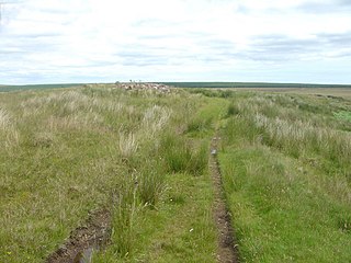
Ca na Catanach is a road and footpath between Sutherland and Caithness through the moorland in the northeastern Scottish Highlands. Noted as a post-medieval drovers' road in the Highland Historic Environment Record, it is also a 22-mile (35 km) Heritage Path. Its start point is at Dorrery Lodge and it ends just north of Achentoul. The nine-mile (14 km) section from Thurso to Kinbrace is a rough walking path. A 19th-century estate road overlies Ca na Catanach. In the 1870s Ordnance Survey recorded that point the drove road crosses the historic county border is atop of an eminence known as Cnoc nan Goile, and the name Ca-na-Catanach only applies to the section between Dorrery and Cnoc nan Goile.

The River Helmsdale is one of the major east-flowing rivers of Sutherland in the Highlands of Scotland. It flows broadly southeastwards from Loch Badanloch down the Strath of Kildonan, gathering the waters of the Bannock Burn on its left and the Abhainn na Frithe on its right before discharging into the Moray Firth on the North Sea at the town of Helmsdale. Other significant tributaries of the Helmsdale include the left-bank Suisgill Burn and the right-bank Craggie Water. Loch Achnamoine which is just over 1 km in length, lies on the line of the river 1 mi / 1.5 km downstream of Loch Badanloch. Loch Badanloch is one of a complex of three interconnecting lochs - the other two being Loch nan Clàr and Loch Rimsdale which gather waters from the moors on the southern edge of the Flow Country via the Allt an Lòin Tharsuinn, Allt Lòn a' Chùil and Rimsdale Burn.
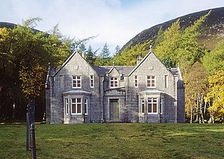
Glas-allt-Shiel is a lodge on the Balmoral Estate by the shore of Loch Muick in Aberdeenshire, Scotland. In its present form it was built in 1868 by Queen Victoria, who called it Glassalt, to be what she called her "widow's house" where she could escape from the world following the death of her husband Albert. It is now a category B listed building owned personally by Charles III. Adam Watson considers that "Glas-allt-Shiel has undoubtedly one of the most spectacular situations of any lodge in the Highlands."
Loch Dionard is a medium-sized loch in the Durness Parish, in Sutherland, Highland Council Area, Northern Scotland. It is in the North-Western Highlands about four miles south of Polla.
Loch Merkland is a large long inland loch in Sutherland, Northern Scotland. It is located adjacent to the A838 main road which provides almost all access to the Loch and the Merkland Lodge to the south of it. There are many trails and hiking paths in the area, as per usual in the highlands of Scotland. On the Banks just above the Lodge there's also Merkland Cottage meaning there are residents around the Loch.

Loch Borralan is a freshwater loch in the Assynt District of Sutherland in the Highland Council Area, northern Scotland.
Loch Nan Clar is a loch in Sutherland in the Highland Council Area of northern Scotland. It is located near the B871 main road, and there is no settlement directly on the lake although the hamlets of Gearnsary and Garvault are very nearby. The loch is used as both a reservoir and as one of few salmon fishery areas in Highland.
Loch Rimsdale is a loch in the Farr parish in Sutherland in the Highland Council Area of northern Scotland. It is located near the B871 main road. There are no settlements directly on the loch however the hamlet of Gearnsary and the Farmstead of Rimsdale are very nearby. The loch is used as both a reservoir and as one of few salmon fishery areas in Highland.
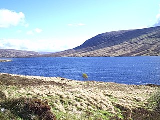
Loch Hope is a loch in the Durness parish in Sutherland in the Highland Council Area of northern Scotland. It is located on the A838 main road. The settlements of Hope, Lochside, and Muiseal directly on the loch in addition nearby there's Inverhope, Heilam, Moine House, Alltnacaillich, Strathmore, ect.. The Loch is a large tourist destination for the area around it.
Loch Naver is a loch in the Farr parish in Sutherland in the Highland council area of northern Scotland. It is situated upon the B873 main road. Upon the loch are also the settlements of Kilbreck, Redhackaistelll and Dailmallhart. Additionally Alltnaharra and Achanaes are nearby. Fishing is very popular on Loch Naver and the River Naver.
Loch Choire is a loch in Sutherland in the Highland council area of northern Scotland. It is located at the end of a rural street which links the loch and the lodges around it with Badanloch Lodge and the B871 main road.

