Loch Chon

Last updated

Loch Chon
Loch Chon - geograph.org.uk - 1355394.jpg
View of Loch Chon looking over the north end of the loch towards the country house of Frenich and Loch Ard Forest.
Stirling UK relief location map.jpg
Red pog.svg
Loch Chon
Location Stirlingshire, Scotland
Coordinates 56°12′52″N4°32′53″W / 56.2145°N 4.548°W / 56.2145; -4.548 Coordinates: 56°12′52″N4°32′53″W / 56.2145°N 4.548°W / 56.2145; -4.548
Type freshwater loch
Primary inflows various streams
Primary outflows Water of Chon – Loch ArdRiver ForthFirth of Forth
Max. length2.57 km (1.60 mi) [1]
Max. width0.38 km (0.24 mi) [1]
Surface area105.7 ha (261 acres) [2]
Average depth8.8 m (29 ft) [1]
Max. depth23 m (75 ft) [1]
Shore length17.2 km (4.5 mi) [2]
Surface elevation92 m (302 ft) [2]
Islands Heron Island
1 Shore length is not a well-defined measure.

Loch Chon is a freshwater loch situated west of the village of Aberfoyle, near the small village of Kinlochard, Stirling, Scotland, UK. Loch Chon lies upstream of Loch Ard and to the south of Loch Katrine.

Contents

In the past, Loch Chon was known as Loch-a-Choin [3] - loch of the dog/dogs. Choin is the Scots Gaelic word for dog in its genitive case (coin), lenited because loch is a masculine noun, causing an 'h' to be placed after the 'c'. [4]

It releases its water into the 4.5-kilometre (2.8 mi) long Water of Chon, which not far from the outlet passes Loch Dhu, and is the main affluent of Loch Ard. Loch Chon itself is fed by several small streams which can be considered to be the true sources of the River Forth. [1] [2]

There are three islands in the loch. Two are unnamed, including the largest, which is roughly 315 feet/96 metres long. The medium sized island is called Heron Island [5] and is roughly 230 feet/70 metres long.

Geology

Bathymetrical survey of Loch Chon Bathymetrical survey of the lochs of Scotland, vol.III, plate VIII (Loch Chon).jpg
Bathymetrical survey of Loch Chon

According to Ben Peach and John Horne, published in the 1910 Bathymetrical survey of the Scottish fresh-water lochs, Loch Chon is a striking example of a rock basin. The upper portion of the lake is floored by mica-schists, and the lower portion by Ben Ledi grits and schistose epidotic grits ("Green Beds"), the members of the two latter groups being repeated by sharp folds. The trend of the loch — N.N.W. and S.S.E. — is oblique to the strike of the strata. At the head of the lake there is a broad alluvial flat, where it has been silted up for a distance of one-third mile (0.54 km) by the detritus laid down by the adjacent streams. In the northern part of the basin the deepest soundings vary from 33 to 67 feet (10 to 20 m); but at a point about one-half mile (0.80 km) below the present head of the lake the depth increases from 40 to 60 feet (12 to 18 m) and upwards.

This feature coincides with a line of fault that crosses the loch in a north-east and south-west direction, its downthrow being to the south-east. From this point southwards for one-half mile (0.80 km) there is a narrow basin enclosed within the 50 feet (15 m) contour-line, and within this basin there is a narrow trough, about 100 yards (91 m) long and upwards of 75 feet (23 m) deep, near the west margin of the lake. There is ground for the belief that nearly the whole of the basin bounded by the 50 feet (15 m) contour-line is floored by mica-schist. [6]

About 1 mile (1.6 km) below the head of the lake the soundings prove a remarkable decrease in the depth, the 25 feet (7.6 m) contour-line near the Heron islands being deflected towards the centre of the loch. The shallowing of the basin here takes place along the outcrop of very massive epidotic grits ("Green Beds") several glaciated rocky islands appearing along this line. Southwards to the mouth of the lake there are alternations of Ben Ledi grits and schistose epidotic grits, the narrowest parts of the lake coinciding with the exposures of the latter group. [6]

About 100 yards (91 m) below the outlet of the lake a prominent band of schistose epidotic grits occurs, formed a rocky barrier during the glaciation of that region. Beyond this outcrop there is a small shallow basin, about 41 feet (12 m) deep (Loch Dhu), floored by schistose grits, which is traversed by a fault trending north-east and south-west, with a downthrow to the east. Across the mouth of this basin a band of massive, pebbly grits of the Ben Ledi type has been traced. [6]

The direction of the ice-flow during the great glaciation coincides generally with the trend of the loch, striae being found on the rocky islands as well as round the margin of the lake. The evidence supplied by soundings tends to support the theory that the basin-shaped hollow has been eroded by ice-action. The dislocations referred to above have doubtless produced local modifications of the floor of Loch Chon and Loch Dhu, but they do not account for the excavation of the basin. [6]

Camping

The north and east sides of Loch Chon fall within one of Loch Lomond and the Trossachs National Park's camping management zones, [7] established by the introduction of byelaws in 2017. [8] This means that, between March and September of each year, wild camping is not allowed within 200 metres of the shore line.

However, the west shore of Loch Chon and its islands are not within the camping management zone. Therefore, wild camping is allowed there, provided the other byelaws, such as that prohibiting gathering dead wood, and the Scottish Outdoor Access Code, are followed.

There is a campsite [9] run by the Loch Lomond and the Trossachs National Park on the east side of the loch, open from March through to September. This was established in 2017, as part of the provisions in the byelaws that they provide affordable camping opportunities.

Related Research Articles

Loch Lomond Lake In Scotland

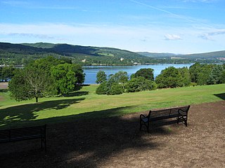
Loch Lomond is a freshwater Scottish loch which crosses the Highland Boundary Fault, often considered the boundary between the lowlands of Central Scotland and the Highlands. Traditionally forming part of the boundary between the counties of Stirlingshire and Dunbartonshire, Loch Lomond is split between the council areas of Stirling, Argyll and Bute and West Dunbartonshire. Its southern shores are about 23 kilometres (14 mi) northwest of the centre of Glasgow, Scotland's largest city. The Loch forms part of the Loch Lomond and The Trossachs National Park which was established in 2002.

Luss Human settlement in Scotland

Luss is a village in Argyll and Bute, Scotland, on the west bank of Loch Lomond. The village is within the Loch Lomond and The Trossachs National Park.

Loch Long Sea-loch in Argyll and Bute, Scotland, UK

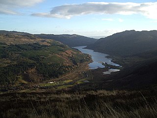
Loch Long is a body of water in Argyll and Bute, Scotland. The Sea Loch extends from the Firth of Clyde at its southwestern end. It measures approximately 20 miles (32 km) in length, with a width of between 1 and 2 miles. The loch also has an arm, Loch Goil, on its western side.

Loch Katrine Body of water

Loch Katrine is a freshwater loch in the Trossachs area of the Scottish Highlands, east of Loch Lomond, within the historic county and registration county of Perthshire and the contemporary district of Stirling. The loch is about 8 miles (13 km) long and 1 mile (1.6 km) wide at its widest point, and runs the length of Strath Gartney. It is within the drainage basins of the River Teith and River Forth.

Loch Lomond and The Trossachs National Park National park in Scotland

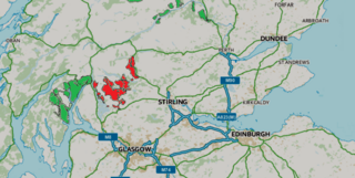
Loch Lomond and The Trossachs National Park is a national park in Scotland centred on Loch Lomond and the hills and glens of the Trossachs, along with several other ranges of hills. It was the first of the two national parks established by the Scottish Parliament in 2002, the second being the Cairngorms National Park. The park extends to cover much of the western part of the southern highlands, lying to the north of the Glasgow conurbation, and contains many mountains and lochs. It is the fourth-largest national park in the British Isles, with a total area of 1,865 km2 (720 sq mi) and a boundary of some 350 km (220 mi) in length. It features 21 Munros and 20 Corbetts.

Loch Lubnaig Loch in Stirling, Scotland, UK

Loch Lubnaig is a small freshwater loch near Callander in the Stirling council area, Scottish Highlands. It lies in the former county of Perthshire. It is part of the Loch Lomond and The Trossachs National Park.

Trossachs Area of wooded hills and lochs in the southern part of the Scottish Highlands

The Trossachs generally refers to an area of wooded glens, braes, and lochs lying to the east of Ben Lomond in the Stirling council area of Scotland. The name is taken from that of a small woodland glen that lies at the centre of the area, but is now generally applied to the wider region.

Drymen Human settlement in Scotland

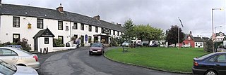
Drymen is a village in the Stirling district of central Scotland. Once a popular stopping place for cattle drovers, it is now popular with visiting tourists given its location near Loch Lomond. The village is centred around a village green which is an unusual feature in Scottish villages but more common in other parts of the United Kingdom.

Loch Ard Body of water

Loch Ard is a loch, located in Loch Lomond and the Trossachs National Park, Stirling council area, Scotland.

Ben Ledi

Ben Ledi is a mountain in Stirling, Scotland. It is 879 metres high, and is therefore classified as a Corbett. It lies about six kilometres northwest of Callander, near the village of Kilmahog. It is situated in the Trossachs, an area often regarded as having some of the most romantic scenery in the Highlands.

Kilmun Human settlement in Scotland

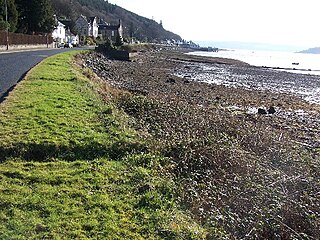
Kilmun is a linear settlement on the north shore of the Holy Loch, on the Cowal peninsula in Argyll and Bute, Scottish Highlands.It takes its name from the 7th century monastic community founded by an Irish monk, St Munn. The ruin of a 12th-century church still stands beside the Kilmun Parish Church and Argyll Mausoleum.

Loch Venachar A lake in Stirlingshire, Scotland

Loch Venachar is a freshwater loch in Stirling district, Scotland.

Balloch Country Park

Balloch Country Park is a 200-acre (0.81 km2) country park on the southern tip of Loch Lomond in West Dunbartonshire, Scotland. It was recognised as a country park in 1980, and it is the only country park in the Loch Lomond and the Trossachs National Park, Scotland's first national park. Balloch Country Park features nature trails, guided walks, a walled garden, and picnic lawns with views of the Loch. It was originally developed in the early 19th century by John Buchanan, a partner in the Glasgow and Ship Bank, and the gardens were significantly improved by the Dennistoun-Browns, who bought the estate in 1851. Buchanan also built Balloch Castle, which now serves as the park's visitors' center.

Carrick Castle Castle in Argyll and Bute, Scotland

Carrick Castle is a 14th-century tower house on the west shore of Loch Goil on the Cowal peninsula in Argyll and Bute, Scotland. It is located between Cuilmuich and Carrick, 4 miles (6.4 km) south of Lochgoilhead.

Benvane

Benvane is a mountain in the Trossachs, in Stirling council area, Scotland. It lies within Loch Lomond and The Trossachs National Park and the Queen Elizabeth Forest Park, and the summit is on the western boundary of the Trossachs National Nature Reserve. It is 821 metres (2,694 ft) high, and is classified as a Corbett, being joined by a ridge to the neighbouring Corbett of Ben Ledi.

Queen Elizabeth Forest Park

Queen Elizabeth Forest Park is a 19,665-hectare (48,590-acre) forest park in the Scottish Highlands which extends from the eastern shores of Loch Lomond to the mountains of Strathyre. The forest park is one of six such parks in Scotland, and was established in 1953, the year of the coronation of Elizabeth II. It is owned and managed by Forestry and Land Scotland.

Loch Iubhair Body of water

Loch Iubhair pronounced yoo-ar meaning yew loch, is a freshwater loch, located in Glen Dochart, and six kilometres east of the village of Crianlarich. Loch Dochart is located immediately southeast, and the outflow of Loch Dochart, as the River Dochart flows into Loch Iubhair.

Stob a Choin

Stob a'Choin is a mountain in the Grampian Mountains, Scotland, north of Loch Katrine in the Loch Lomond and The Trossachs National Park.

The geology of Loch Lomond and The Trossachs National Park in the southwestern part of the Scottish Highlands consists largely of Neoproterozoic and Palaeozoic bedrock faulted and folded and subjected to low grade metamorphism during the Caledonian orogeny. These older rocks, assigned to the Dalradian Supergroup, lie to the northwest of the northeast – southwest aligned Highland Boundary Fault which defines the southern edge of the Highlands. A part of this mountainous park extends south of this major geological divide into an area characterised by younger Devonian rocks which are assigned to the Old Red Sandstone.

References

  1. 1 2 3 4 5 John, Murray; Lawrence, Pullar (1910). Bathymetrical Survey of the Fresh-Water Lochs of Scotland, 1897-1909 Lochs of the Forth Basin Volume II - Loch Chon. Edinburgh: Challenger Office. p. 13. Retrieved 12 May 2018.PD-icon.svgThis article incorporates text from this source, which is in the public domain .
  2. 1 2 3 4 "Loch Chon". British Lakes. Retrieved 12 May 2018.
  3. Robertson, R MacDonald (1961). Selected Highland folktales (1998 ed.). Isle of Colonsay, Argyll [Scotland]: House of Lochar. p. 127. ISBN   1-899863-06-0. OCLC   34118204.
  4. "The Gaelic origins of place names in Britain". OS GetOutside. Retrieved 5 July 2021.
  5. "#GetOutside: do more in the British Outdoors". OS GetOutside. Retrieved 5 July 2021.{{cite web}}: CS1 maint: url-status (link)
  6. 1 2 3 4 Peach, Ben; Horne, John (1910). "Notes on the Geology of the Loch Katrine District". Bathymetrical Survey of the Fresh-Water Lochs of Scotland, 1897-1909 Lochs of the Forth Basin Volume II. Edinburgh: Challenger Office. pp. 50–51.PD-icon.svgThis article incorporates text from this source, which is in the public domain .
  7. Lomond, Loch; G83 8EG, The Trossachs National Park Authority Carrochan Carrochan Road Balloch. "Camping Management Byelaws | Respect Protect Enjoy". Loch Lomond & The Trossachs National Park. Retrieved 5 July 2021.
  8. Lomond, Loch; G83 8EG, The Trossachs National Park Authority Carrochan Carrochan Road Balloch. "Camping in the Park: Feedback & Publications | Respect Protect Enjoy". Loch Lomond & The Trossachs National Park. Retrieved 5 July 2021.
  9. Lomond, Loch; G83 8EG, The Trossachs National Park Authority Carrochan Carrochan Road Balloch. "Loch Chon Campsite | Respect Protect Enjoy". Loch Lomond & The Trossachs National Park. Retrieved 5 July 2021.